Flood and severe threat pushes into mid-Atlantic, Southeast
A front stretched from the Carolinas through Texas will keep afternoon thunderstorms firing into midweek. The focus of the flooding shifts to the mid-Atlantic while a strengthening low puts the risk of thunderstorms, wind and hail over the Tennessee Valley and Carolinas.
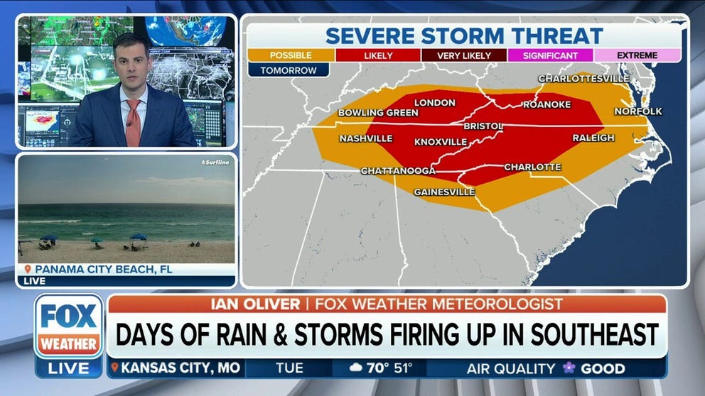
Severe storm threat shifts to TN and OH valleys, mid-Atlantic Tuesday
Severe storms will threaten the Tennessee and Ohio Valleys and parts of the mid-Atlantic on Tuesday. Gusty winds, hail and isolated tornadoes are possible.
Days of relentless rain have led to flash flooding across South Texas, including the San Antonio area, where first responders conducted several swift-water rescues over Mother's Day weekend. River flooding remains a concern in Texas while the threat of widespread flooding and severe weather shifts to the Heartland and Southeast.
RELENTLESS RAIN PROMPTS FLASH FLOODING THREAT IN SOUTH, MID-MISSISSIPPI VALLEY

St. Louis experiences serious flash flooding after storms move through
St. Louis experienced serious flash flooding Sunday night after storms moved through dumping heavy rain across the city.
Heavy rain led to flooding issues across the St. Louis metro on Sunday night, prompting Flash Flood Warnings for the area. Video from the area showed cars stuck under an overpass when heavy rain resulted in flash flooding.
Texas high water rescues continued Tuesday. The Texas A&M Task Force 1 alone rescued five people, three horses, two cows, three doves and 68 goats.
![]() Image 1 of 4
Image 1 of 4Trapped goats on a rescue boat. (Texas A&M Task Force 1)
![]() Image 2 of 4
Image 2 of 4A driver drove around a barrier and his car overturned in the floodwater. (Texas A&M Task Force 1)
![]() Image 3 of 4
Image 3 of 4Several homeowners and pets were evacuated. (Texas A&M Task Force 1)
![]() Image 4 of 4
Image 4 of 4Flooding trapped livestock. (Texas A&M Task Force 1)


Several River Flood Warnings are in effect across southeastern and eastern Texas as rivers run high after the recent heavy rain.
EXPLAINING FLOOD ALERTS ISSUED BY THE NATIONAL WEATHER SERVICE

(FOX Weather)
HERE'S WHAT TO DO IF YOUR CAR IS FLOODED
Overnight and Tuesday threat
The FOX Forecast Center said flash flooding is likely across portions of the central and southern Plains and the mid-Mississippi Valley..
A west-to-east oriented cold front will drop south into southern Missouri and northern Arkansas. As it does, the steady influx of moisture and increasing instability in the atmosphere should raise the risk of heavy rain that could lead to flooding.
(FOX Weather)
Based on the latest data from computer forecast models, the FOX Forecast Center believes the greatest risk will be centered across eastern Oklahoma and the Ozarks in Missouri.
A low pressure system organizing along the front in the Tennessee Valley creates a likely threat across Kentucky, Tennessee, North Carolina and Virginia.

(FOX Weather)
"The strongest storms will be capable of hail and damaging wind gusts, as well as frequent lighting," said the FOX Forecast Center. "The tornado threat will be very low with these storms."
Flood risk continues through midweek
PLAN, PREPARE, PROTECT: HOW TO BEST COVER YOUR PROPERTY AGAINST FLOODS

(FOX Weather)
Jackson and southern Mississippi could also see some flooding if heavy rain develops. The risk will extend north and east into Birmingham and Montgomery, Alabama, into Wednesday.

(FOX Weather)