Forecast intensifies for sprawling winter storm, foot of snow possible in Carolina, Tennessee mountains
As the fast-moving clipper continues to head south, the cold front behind the system will become the primary driver for the rain and snow throughout the Great Lakes and Appalachians region.

More heavy snow for Great Lakes as winter storm could bring foot of snow to southern Appalachians
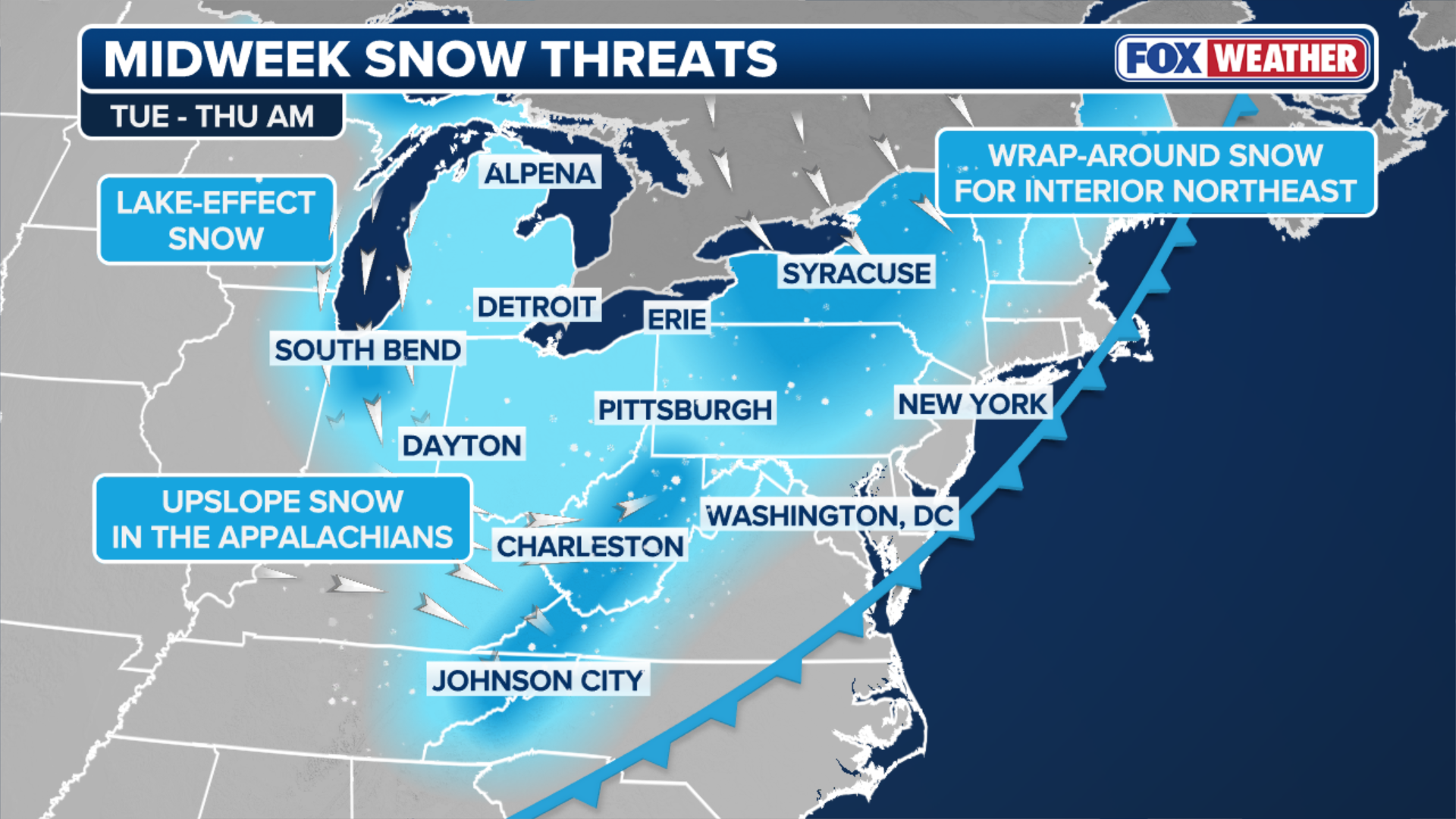
Cold rain is falling from parts of the Gulf Coast to the Ohio Valley on Wednesday morning, ahead of the next winter storm, which is expected to impact at least 25 states and bringing snow showers as far south as North Carolina and Tennessee. Higher elevations in the southern Appalachians are expected to receive up to a foot of snow. Meanwhile, lake-effect snowbelts in the Midwest and interior Northeast are once again in the bull's eye for the highest accumulations.
Cold rain is falling from parts of the Gulf Coast to the Ohio Valley on Wednesday morning, ahead of the next winter storm, which is expected to impact at least 25 states and bring snow showers as far south as North Carolina and Tennessee. Higher elevations in the southern Appalachians are expected to receive up to a foot of snow.
Meanwhile, lake-effect snowbelts in the Midwest and interior Northeast are once again in the bull's eye for the highest accumulations.
Winter Weather Alerts have been posted for downwind of both Great Lakes.

People walking through heavy snow in Chicago on Saturday.
(Robert Ray / FOX Weather)
As the fast-moving clipper continues to head south, the cold front behind the system will become the primary driver for the rain and snow.
WHAT ARE WINTER WEATHER ALERTS?
According to the FOX Forecast Center, light snow may develop across parts of the Ohio Valley on Wednesday, with little to no accumulations expected, but brief bursts of snow could still create sudden travel issues if visibility drops quickly.
Locations along the I-95 corridor are expected to see minimal impacts.
(FOX Weather)
The cold air moving in behind the system will support lake-effect and lake-enhanced snow near the Great Lakes, along with upslope snow across the Appalachians.
The most intense snowfall is expected to begin Wednesday night from much of the Lake Michigan shoreline in Michigan westward toward the Indiana–Illinois border.
Within this corridor, snow totals could exceed 8 inches and potentially approach a foot in the most persistent band, the FOX Forecast Center said Wednesday.

Heavy snow impacting Doylestown, Pennsylvania.
(WXVision / FOX Weather)
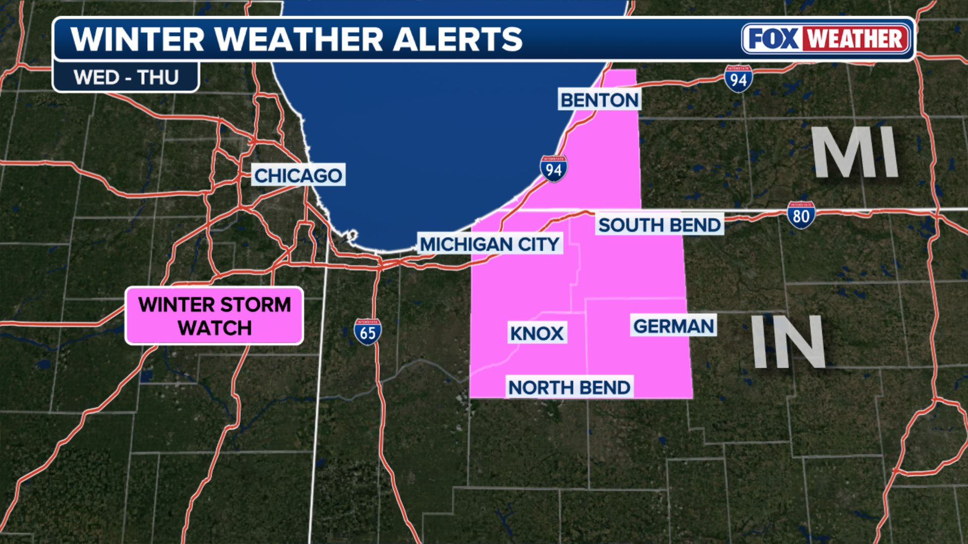
The National Weather Service has issued a Winter Storm Watch for the southern shore of Lake Michigan, including South Bend, Indiana, from Wednesday through Thursday.
(FOX Weather)
Places like South Bend, IN and Michigan City, IN are already at a major snow surplus with close to a foot above average for this time of the year.
WINTER STORM WATCH EXPLAINED: WHAT DOES IT MEAN AND WHEN IS IT ISSUED?
Lake Superior near Marquette, as well as Lake Erie, Lake Ontario, parts of northern Pennsylvania and Upstate New York will experience lake-effect and lake-enhanced snowfall as well.

Dangerous snow blankets Michigan during post-holiday winter storm
(Brandon Copic / FOX Weather)
Meanwhile, the storm will start to make its way through the Appalachians starting late on Wednesday, mostly affecting the mountain region.
HOW TO SURVIVE IN YOUR CAR IF YOU'RE STUCK IN A WINTER STORM
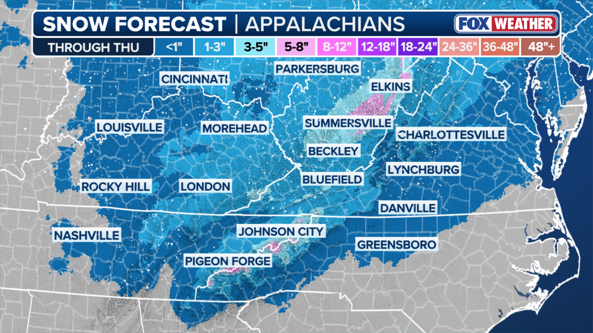
As the winds move northwest, snow showers will increase into early Thursday. The upslope snow will occur in the high terrain from the Tennessee and North Carolina border, northward into West Virginia and along the highest peaks of the Appalachians.
More snow is now expected at these higher elevations, with up to a foot possible, according to recent computer forecasts.
(FOX Weather)
While, even some of the lower elevations could see 3-5 inches of snow.
The snow is expected to taper by Thursday afternoon.