Back-to-back winter storms to bring accumulating snow to Upper Midwest, Great Lakes
Cold air remains locked in place, and that’s setting the stage for a one-two punch of winter weather, including the possibility of accumulating snow for cities like Minneapolis, Chicago and Green Bay in Wisconsin.
Quick-moving storm systems to produce spring snow
Minneapolis and Green Bay are expected to see several inches of snowfall through the workweek.
MINNEAPOLIS – Despite the calendar showing its spring, winter is refusing to release its grip on the Midwest and Great Lakes region as the FOX Forecast Center tracks back-to-back winter storms expected to bring accumulating snow to cities like Minneapolis and Green Bay over the next several days.
WHEN IS THE LAST FREEZE IN MY AREA?

(FOX Weather)
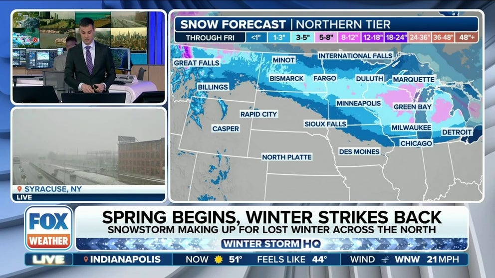
Fast-moving storm bringing snow to northern tier
The pattern change includes a large dip in the jet stream, which is allowing for cold temperatures to remain across the region.
A weather disturbance originating in the Northwest off the Pacific Ocean will zip across the northern tier from the Rockies to the Great Lakes and then eventually into the Northeast.
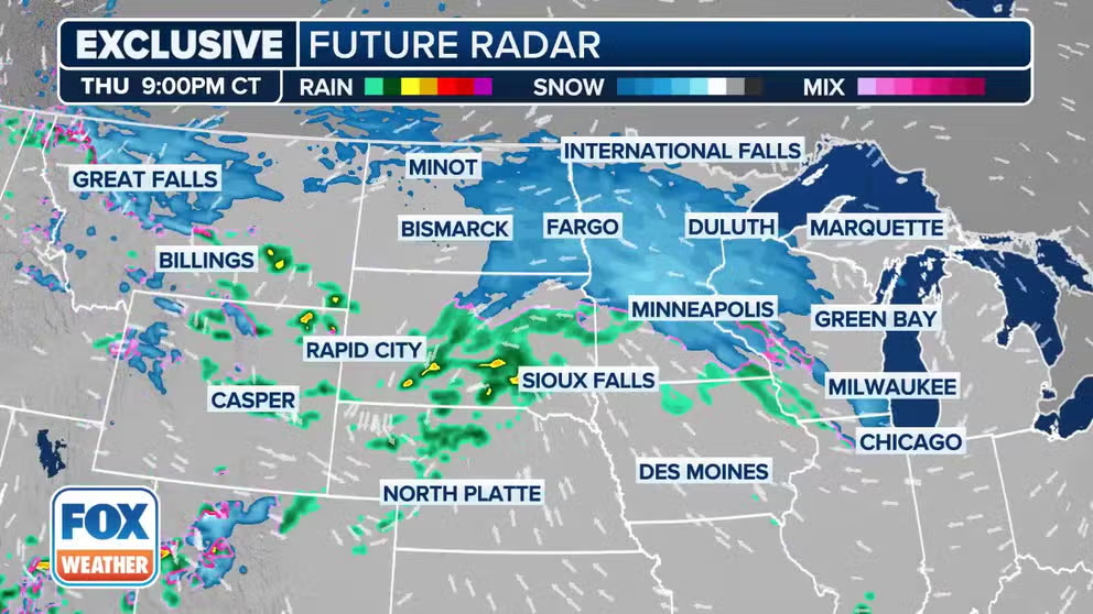
Watch: Exclusive FOX Model Futuretrack shows winter storm bringing snow to Midwest, Great Lakes
The exclusive FOX Model Futuretrack shows a winter storm that is expected to bring snow to the Upper Midwest and Great Lakes region over the next few days.
Cold air will be in place, but it will be slightly warmer to the south. That change in temperature will provide the lift needed to tap into the Pacific moisture as the system moves across the northern tier.
WHEN CAN YOU EXPECT THE LAST SNOW OF THE SEASON?

(FOX Weather)
The anticipated heavy snow has prompted Winter Storm Warnings for portions of western Montana that will remain in effect through Saturday. The National Weather Service said total snow accumulations between 5 and 15 inches are expected across lower elevations, while up to 22 inches could fall in the higher terrain.
Winter Weather Advisories have been issued across northern Montana, including cities such as Glasgow, Havre and Sidney.
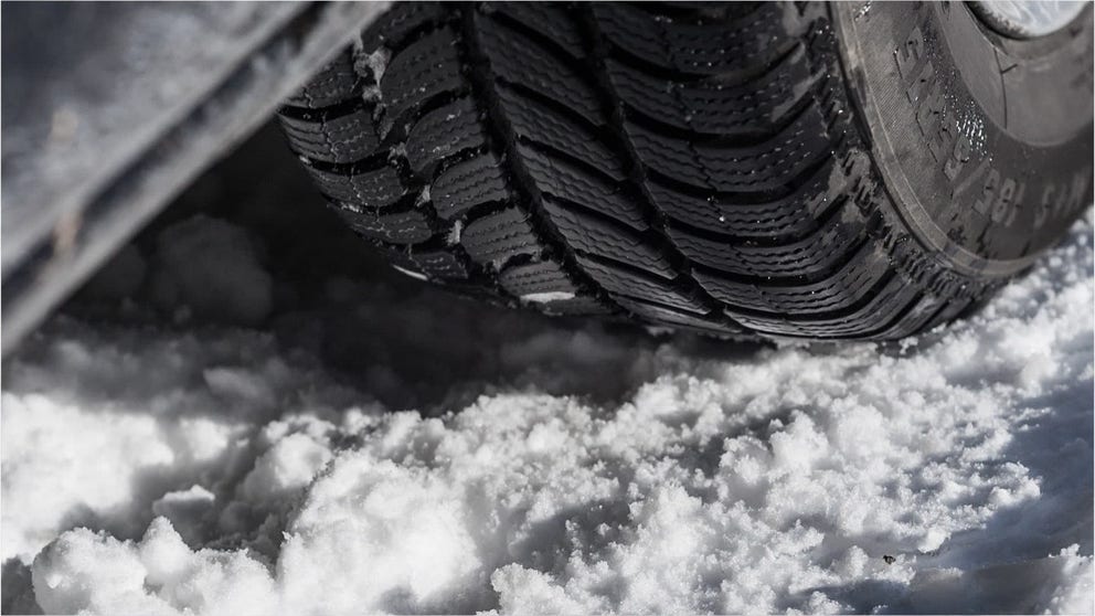
DRIVING ON THE ICE AND DRIVING IN THE SNOW: WEATHER DRIVING TIPS FOR DRIVING IN INCLEMENT WEATHER

(FOX Weather)
The Midwest, including cities like Minneapolis, Milwaukee and Green Bay in Wisconsin, will start to see snowflakes fly later in the day on Thursday and into Thursday night.
Chicago will be at risk of seeing snow, but significant accumulations aren’t expected at this time.
By Friday, more major cities will start to see snowfall, including Detroit and Buffalo and Syracuse in New York.
TRAVELING THIS WINTER? HERE'S WHAT TO KEEP IN YOUR CAR IN CASE YOU GET STUCK
How much snow is expected from this week's storm?
This by no means will be a blockbuster winter storm in terms of snow accumulations, but it could lead to some tricky travel.

(FOX Weather)
Most areas from the Plains to the Midwest can expect a few inches of snow, with some pockets picking up 5-8 inches, including central Minnesota and eastern Wisconsin. Central Michigan and the Upper Peninsula could also pick up 5-8 inches from the first blast of winter weather this week, with some locally higher amounts.
There is enough snowfall in the forecast that this week could end up the snowiest week since last winter in Minneapolis, as the city is amid its third-least-snowy winter on record. Only 14.3 inches have fallen since October. The last time Minneapolis recorded an inch of snow was back in February before a stretch of record-high temperatures in its wake.
And Duluth, Minnesota, farther to the north, has had its least-snowy winter on record, recording only 19 inches since October – nearly 57 inches below average.
Second storm system set to be more impactful

(FOX Weather)
The second storm forecast to move across the region early next week will likely bring a more significant impact.
A blocking pattern to the north in Alaska and Canada is expected to develop and will allow for an extended dip in the jet stream across the Rockies, adding another significant blast of cold air into the central U.S.
But farther to the south, strengthening southerly winds will allow for moisture to be brought farther north.
YOU WERE JUST INVOLVED IN A WEATHER-RELATED CRASH - NOW WHAT?
7 things you need to know about winter driving
Winter driving season is here and knowing the science may keep you safer on the snow and ice.
That collision between the warm, moisture-rich air from the south and the arctic blast from the north will help spawn what could be a high-impact storm by the end of the weekend and into the first part of the new workweek.
It's too early to peg specific forecasts for where and how much snow could fall, but the FOX Forecast Center said a significant snowstorm could be in the works. Heavy snow amounts could fall in much of the Dakotas, Minnesota, northern Wisconsin and Michigan's Upper Peninsula.
Ice is also a concern for portions of southern South Dakota and northern Nebraska in the Plains, as well as northern Iowa, southern Minnesota and western Wisconsin.
"A combination of heavy snow and gusty winds, as well as freezing rain south of the heavy snow, could result in hazardous travel and impacts to infrastructure," the National Weather Service warned.
Be sure to download the free FOX Weather app and enable notifications to not only be alerted to important weather alerts but to also be among the first to know of any changes to the forecast.