Bomb cyclone expected as parade of winter storms continues to slam West
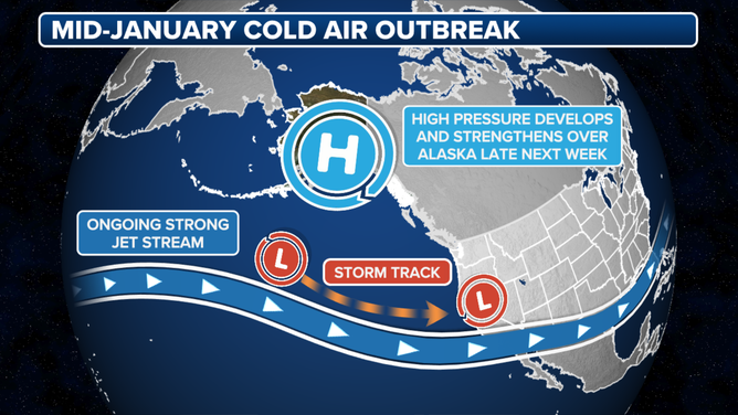
The jet stream is sending storm after storm into the West Coast and the pattern continues through next week. The early week storm will rapidly strengthen to a bomb cyclone and create a travel nightmare for the Pacific Northwest.
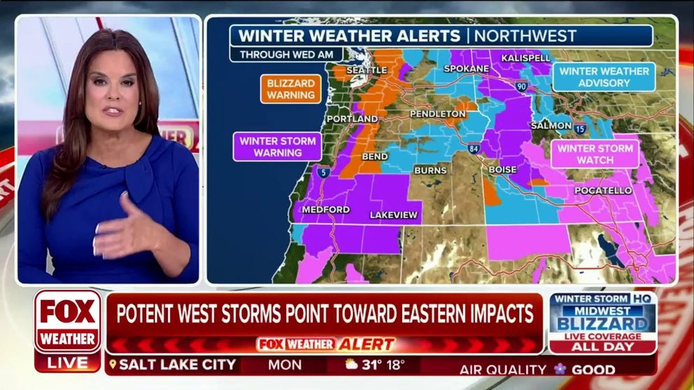
Rare blizzard Warnings issued for Pacific Northwest
As the series of western storms continue to march on the Northwest, the NWS has issued some rare warnings. Seattle's NWS hadn't issued a Blizzard Waring in 11 years. Meteorologist Amy Freeze explains who else will be clobbered by the most recent winter storm.
The West has become a winter storm superhighway, and the next storm to slam the coast is expected to "bomb out" or rapidly intensify before moving ashore.
"The floodgates, or should it be snowgates, have opened across the West with an incredibly active period for the next 7 days," said the FOX Forecast Center. "Multiple storms will swing through the region, dropping feet of snow, leading to dangerous road conditions throughout the region."

(FOX Weather)
The jet stream is sending storms into the Pacific Northwest. The storms regroup on the eastern side of the Rockies and wallop the southern and eastern parts of the nation.
NEW POWERFUL WINTER SYSTEM TO SLAM CENTRAL, EASTERN US WITH BLIZZARD, FLOODING, SEVERE WEATHER
(FOX Weather)
The weekend storm turned the mountains into a winter wonderland. The cold front ushered in cold air, dropping Napa, California, to freezing Sunday morning. And Tucson, Arizona, even saw flurries on palm trees Sunday morning.
HOW COLD DOES IT HAVE TO BE TO SNOW
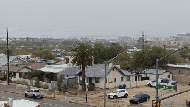
Snow even fell on palm trees in Tucson, Arizona Sunday.
(FOX Weather)
The next two storms arrive this week. They will follow a similar storm path to the nor'easter that clobbered New England over the weekend.
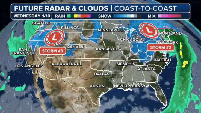
Two more storms will ride the jet stream from the West into the Southern Plains, then into the Northeast after storm 2.
(FOX Weather)
WHAT'S THE DIFFERENCE BETWEEN A FROST, A FREEZE AND A HARD FREEZE?
The Seattle office issued the first Blizzard Warnings in over 11 years from early Tuesday morning through Wednesday in mountain areas above 3,000 feet. The NWS office in Portland, Oregon, also issued a rare Blizzard Warning above 3,500 feet. Winter Storm Warnings go into effect for those states on Monday morning.
"Travel Tuesday through early Wednesday should be restricted to emergencies only," read the NWS Blizzard Warning. "If you must travel, make sure your cell phone is charged, make sure someone knows where you`re going, and be sure to have a winter survival kit with you."

(FOX Weather)
Monday
A front ushered in relatively warm air and light precipitation early on Monday, but rain and snow will pick up later in the day as the system is fed by an atmospheric river, according to the Weather Prediction Center. The precipitation stays a rain-snow mix in the mild and tropical air until the cold front sweeps through early Tuesday.
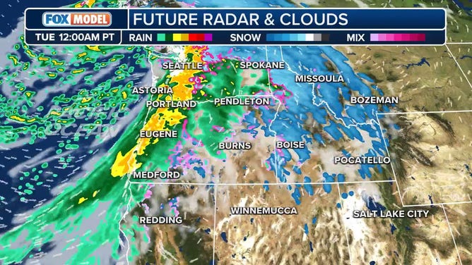
Rain and snow pick up Monday night.
"Meanwhile, a new surface low will quickly intensify into a 970-975 mb (strong storm) behemoth as it undergoes rapid cyclogenesis ahead of a strengthening upper-level shortwave trough digging southeast out of the Gulf of Alaska," wrote Seattle's NWS office. This is the storm that is expected to become a bomb cyclone.
Heavy snow starts very late Monday into Tuesday morning at rates of half to one inch an hour.
Tuesday
The NWS warned in their forecast discussion that Tuesday will be the heaviest snow day for the Pacific Northwest. Snow levels will start very high but drop through the day below pass levels. Tropical storm-force winds will blow the snow around, creating dangerous to near-impossible travel.
Winds could gust 30 to 60 mph. The NWS warns of downed tree limbs and power lines.
OROGRAPHIC LIFTING: HOW MOUNTAINS CAN HOG THE RAIN
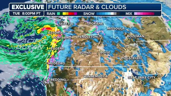
The bomb cyclone approaches late Tuesday.
(FOX Weather)
The lowlands are in for moderate to heavy rain and strong winds. Don't be surprised to see a thunderstorm with small hail along the coast. The storm could churn 25 to 28-foot waves, resulting in 15 to 30-foot breaking waves. Watch for up to 2 to 3 feet of coastal flooding during the high king tide for the Pacific Northwest, according to the NWS.
Snowfall across the Cascades and Olympics above 2,000 would see 2 to 5 feet of snow, according to the NWS.
California will get off relatively light in terms of rain and snow, under an inch of rain for Northern California. The cold will sink well into the Central Coast, though.

(FOX Weather)
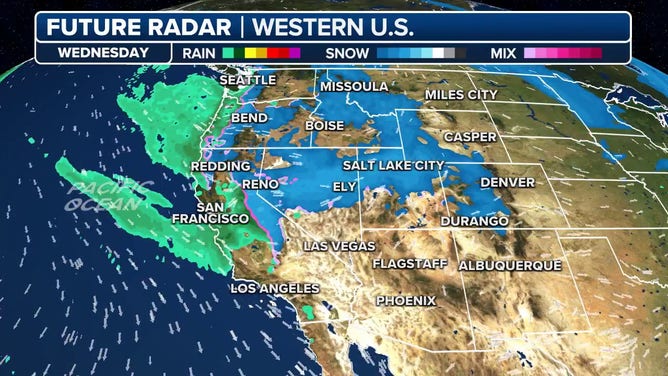
Wednesday into the weekend
The storm departs the Pacific Northwest Wednesday, leaving some lingering rain and snow. California will see the wind, rain and snow. Tahoe's peaks could see up to a foot of new snow. The NWS warns that lower elevations will see wind gusts to 45 mph, 60 mph in wind-prone areas and near 100 mph for the Sierra ridges.
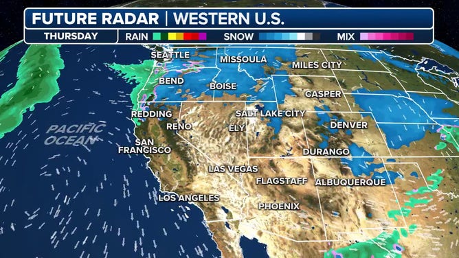
Chunks of energy slide through the coast, translating to unsettled weather continuing through Thursday and Friday as the coldest air of the season sinks south with a secondary cold front.
![]() Image 1 of 3
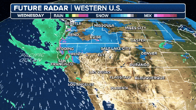
Image 1 of 3Wednesday the storm is clearing out. ( )
![]() Image 2 of 3
Image 2 of 3Thursday should be the "driest day" in the unsettled week. ( )
![]() Image 3 of 3
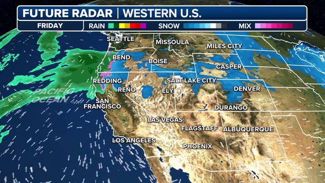
Image 3 of 3The next storm approaches late Friday and Saturday. ( )
"A period of below normal temperatures is increasingly likely, but it is hard to say just how cold at this point," wrote the NWS. "Best chances for lows well below freezing will be north of Seattle into western Snohomish, Skagit, and Whatcom Counties."
Higher elevations could see up to a foot of new snow through the workweek.
The next rain and snow maker comes Saturday.
(FOX Weather)
The next impressive storm approaches Friday through the weekend.