Severe Thunderstorm Watches issued from Kentucky to Vermont, days after deadly flooding
More than 5 million people are currently under a Severe Thunderstorm Watch until 8 p.m. EDT across parts of northwestern Connecticut, western Massachusetts, central and eastern New York and all of Vermont.

Northeast bracing for downpours on Thursday
More than 5 million people are currently under a Severe Thunderstorm Watch until 8 p.m. EDT across parts of northwestern Connecticut, western Massachusetts, central and eastern New York and all of Vermont.
RUTLAND, Vt. – While New England recovers from the worst flooding it has seen in 96 years, the next round of rain is already developing.
A Severe Thunderstorm Watch until 9 p.m. EDT across parts of extreme southeast Indiana, eastern Kentucky, southern Ohio, extreme southwest Pennsylvania and western and central West Virginia. And a Severe Thunderstorm Watch is also in effect until 8 p.m. EDT for much of New York, all of Vermont and parts of Massachusetts and Connecticut.

(FOX Weather)
A series of disturbances will help produce scattered showers and thunderstorms across the Northeast starting again Thursday and continuing into the weekend.
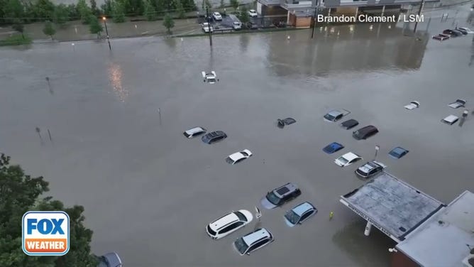
Cities and towns across the Northeast and New England have picked up more than a half-foot of rain since Sunday, with some areas receiving more than 9 inches.
At least two people were killed in the flooding in New York and Vermont, which left the region reeling after its worst flooding event since 1927.
![Flooding in downtown Montpelier, Ver]() Image 1 of 8
Image 1 of 8Flooding in downtown Montpelier, Vermont on Tuesday, July 11, 2023. (John Tully for The Washington Post)
![MONTPELIER, VT - JULY, 11: Flooding in downtown Montpelier, Vermont on Tuesday, July 11, 2023. Vermont has been under a State of Emergency since Sunday evening as heavy rains continued through Tuesday morning causing flooding across the state.]() Image 2 of 8
Image 2 of 8Flooding in downtown Montpelier, Vermont on Tuesday, July 11, 2023. Vermont has been under a State of Emergency since Sunday evening as heavy rains continued through Tuesday morning causing flooding across the state. ( John Tully for The Washington Post)
![MONTPELIER, VT - JULY, 11: Members of the Colchester Technical Rescue team respond to a call to evacuate two adults and an infant from their downtown Montpelier, Vermont apartment on Tuesday afternoon, July 11, 2023. Vermont has been under a State of Emergency since Sunday evening as heavy rains continued through Tuesday morning causing flooding across the state.]() Image 3 of 8
Image 3 of 8Members of the Colchester Technical Rescue team respond to a call to evacuate two adults and an infant from their downtown Montpelier, Vermont apartment on Tuesday afternoon, July 11, 2023. (John Tully for The Washington Post)
![Heavy Rains Cause Catastrophic Flooding In Vermont]() Image 4 of 8
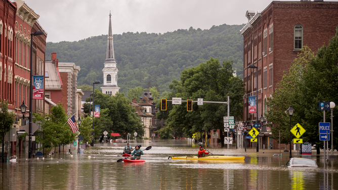
Image 4 of 8Main Street is flooded on July 11, 2023 in Montpelier, Vermont. Up to eight inches of rain fell over 48 hours and residents were warned that Wrightsville Dam could reach capacity, forcing it to release more water that could impact the downtown area. (Kylie Cooper)
![People kayak up and down the flooded waters of Elm Street on July 11, 2023 in Montpelier, Vermont.]() Image 5 of 8
Image 5 of 8People kayak up and down the flooded waters of Elm Street on July 11, 2023 in Montpelier, Vermont. (Kylie Cooper)
![Daylight drone video shows catastrophic flooding submerging downtown Montpelier, Vermont]() Image 6 of 8
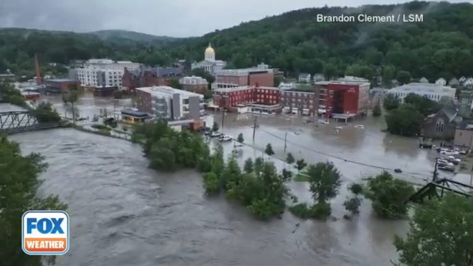
Image 6 of 8Vermont’s capital, Montpelier, was underwater Tuesday morning. Storm chaser Brandon Clement with Live Storms Media captured daylight video answering questions for anyone wondering the scale of the flooding in the historic downtown district. The area is closed until at least noon EDT. (Brandon Clement / LSM)
![Daylight drone video shows catastrophic flooding submerging downtown Montpelier, Vermont]() Image 7 of 8
Image 7 of 8Vermont’s capital, Montpelier, was underwater Tuesday morning. Storm chaser Brandon Clement with Live Storms Media captured daylight video answering questions for anyone wondering the scale of the flooding in the historic downtown district. The area is closed until at least noon EDT. (Brandon Clement / LSM)
![Daylight drone video shows catastrophic flooding submerging downtown Montpelier, Vermont]() Image 8 of 8
Image 8 of 8Vermont’s capital, Montpelier, was underwater Tuesday morning. Storm chaser Brandon Clement with Live Storms Media captured daylight video answering questions for anyone wondering the scale of the flooding in the historic downtown district. The area is closed until at least noon EDT. (Brandon Clement / LSM)


These areas that were hit hard by catastrophic flooding earlier this week, including Vermont, will be especially susceptible to additional flash flooding. An additional 3 to 5 inches of rain is expected throughout the Northeast through Saturday.
"We're just days off of a Flash Flood Emergency in the lower Hudson Valley and Vermont," FOX Weather meteorologist Britta Merwin said. "And we're going to pull in these storms that could bring back some heavy rain, but also destructive weather when you are trying to move forward after a Flash Flood Emergency."

(FOX Weather)
An upper-level trough of low pressure and a weak cold front will gradually slide eastward Thursday toward the East Coast, renewing chances for thunderstorms and heavy rain from the Ohio Valley to the Northeast as southerly flow ahead of the system draws moisture northward, the FOX Forecast Center said.
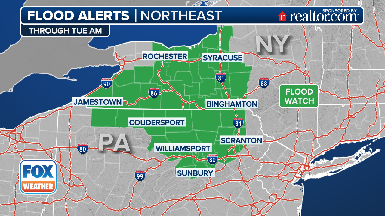
Upstate New York, interior New England and the upper Ohio Valley are at risk for additional flash flooding through Friday.
"We do have a Flood Watch that remains up for parts of New York and Vermont," Merwin said. "This is in response to what's happened, but also for what is still to happen."
(FOX Weather)
The more significant flash flood threat shifts farther east to near the Atlantic coast on Friday, with more of New England and parts of the mid-Atlantic facing an increased risk of flooding, according to the FOX Forecast Center.
The flash flood threat will then lower on Saturday but could still be possible with any of the heavier rain and thunderstorms that develop.
Large hail, damaging winds expected across Northeast, Ohio Valley on Thursday
Numerous severe thunderstorms are likely across eastern New York and western Vermont, producing damaging winds, large hail and even a couple of tornadoes Thursday afternoon and evening.
NOAA's Storm Prediction Center (SPC) has highlighted Schenectady, Utica, Rome, Saratoga Springs and Rotterdam in New York as some of the larger cities in the Northeast in a level 3 out of 5 risk zone for severe weather.
The level 2 out of 5 risk for severe storms covers an even larger area in the Northeast and westward into the Ohio Valley.

(FOX Weather)
"So if you hear that Tornado Warning in Pennsylvania, it's not a joke. It's reality," Merwin said. "You need to make sure that you're taking it seriously and seeking shelter."
The SPC's outlook includes a 5% tornado risk area over eastern New York state, with a much larger 2% tornado risk area stretching from the Ohio Valley to Vermont.

(FOX Weather)