Typhoon Mawar lashes Guam: Direct hit with winds up to 140 mph leads to destruction across US territory
The National Weather Service in Guam said Typhoon Mawar's winds have brought down wind sensors and its Doppler radar, and a wind gust of 105 mph was reported at Guam International Airport.
Mawar restrengthens into a super typhoon west of Guam
Super Typhoon Mawar is headed westbound away from Guma and in the direction of Taiwan and the northern Philippines.
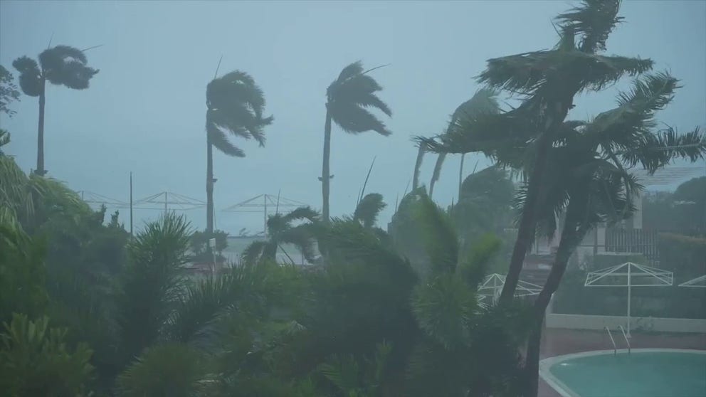
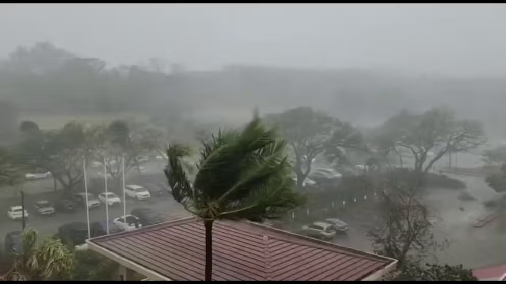
Powerful Typhoon Mawar lashed the U.S. island territory of Guam in the Western Pacific Ocean on Wednesday with winds possibly reaching 140 mph that knocked out power, brought down trees and caused major structural damage to buildings.
Destructive winds and torrential rain were reported across the island, and the typhoon's effects have been widespread.
According to the Guam Power Authority, about 51,000 power outages were reported as of Wednesday evening, local time, meaning 98% of the island is without power.
WHAT'S THE DIFFERENCE BETWEEN A TYPHOON AND SUPER TYPHOON
Watch: Typhoon Mawar lashes US territory of Guam with destructive winds
The U.S. island territory of Guam was lashed by Typhoon Mawar on Wednesday, May 24, 2023. Destructive winds and torrential rain was reported across the island. Nearly 98% of Guam was without power and a 108 mph wind gusts was reported at Guam International Airport.
As Typhoon Mawar’s ferocious winds howled in the background, Guam Gov. Lou Leon Guerrero posted a video message to Facebook during the height of the storm to provide important updates on the unfolding situation.
Guerrero explained that at the time the video was posted, the worst of Typhoon Mawar’s effects were being felt across the island.
"I will be making an assessment of the devastation of our island as soon as it’s safe for me to go outside," she said in the video message. "I ask you to please stay home until I declare Condition of Readiness 4."
WHAT IS AN ‘EXTREME WIND WARNING’?
Readiness 4 means, she added, that the island of Guam is safe for residents to travel.
"Please, I ask you to follow these instructions for your safety and for your protection," Guerrero pleaded.
A defense official confirmed to FOX Weather that USS Nimitz Carrier Strike group is heading towards to the western Pacific and is prepared to assist.
NWS receives 'quite a bit of loss' due to Typhoon Mawar
Exhausted staff with the National Weather Service in Guam provided an update on the latest with what was happening with Typhoon Mawar on the island and said widespread damage has been reported.
"Our staff are taking turns, getting naps," the NWS said in a video update. "We’ve been here for two nights now and over one full day, at least, during the duration of this storm."
The NWS said morale was high and their emotions were "in a good space" as the powerful storm, equivalent to a Category 4 hurricane, began to finally pull away from Guam.
Watch: Ferocious winds from Typhoon Mawar whip across US island territory of Guam
United States Coast Guard Lt. Eric Juback recorded video from a hotel on the U.S. island territory of Guam as powerful Typhoon Mawar lashed the region with destructive winds and torrential rain.
"We have some damage outside, mainly from structures that have taken the wind damage apart from our facility," the NWS continued. "We did lose all of our trees on our property. So, we’ve taken quite a bit of loss of our trees on our property."
Otherwise, the NWS said, its staff is safe and the facility "is in good shape," although it has been running on generator power since Typhoon Mawar knocked out power across the island.
During an earlier update, the NWS was urging people to take cover and continue to shelter in interior rooms of reinforced, concrete buildings while the Mawar slammed Guam.
The winds were so strong at the NWS office that the building was vibrating.
"We have a constant low rumbling," the NWS said. "Our doors and windows are shaking."
5 DIFFERENT NAMES FOR HURRICANES AROUND THE WORLD
The NWS in Guam said Typhoon Mawar's winds have brought down wind sensors and its Doppler radar, and a wind gust of 105 mph was reported at Guam International Airport.
"Considerable wind damage to buildings of light material is occurring along with localized flash flooding and the possibility of landslides," the NWS said. "Significant coastal erosion is likely, particularly along western shorelines."
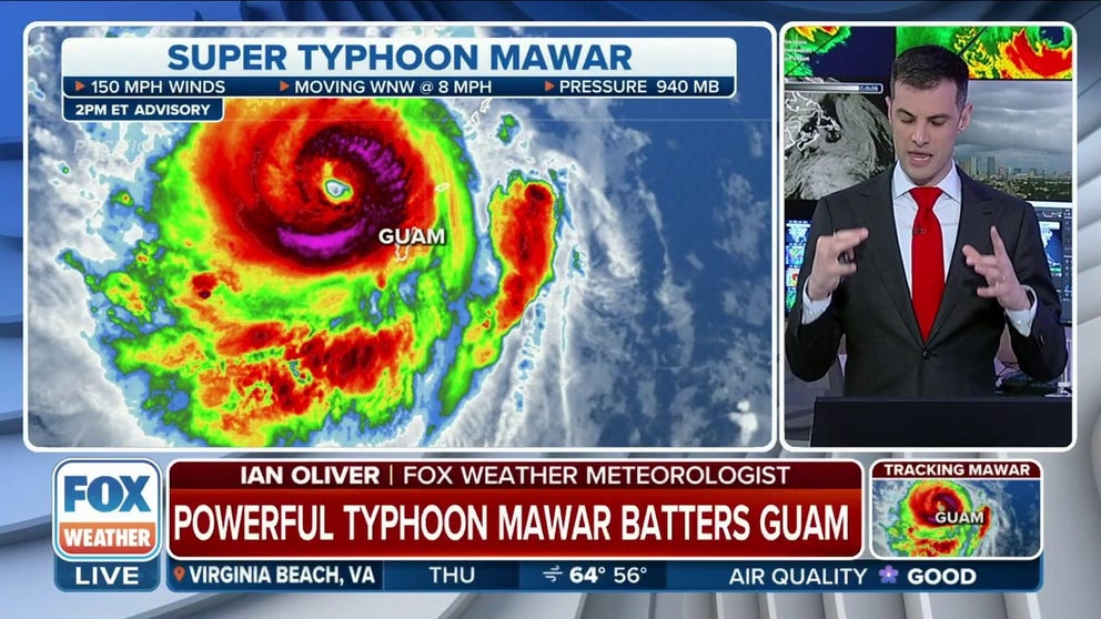
Where is Super Typhoon Mawar right now?

(FOX Weather)
As of 6 a.m. Thursday, local time, Super Typhoon Mawar had maximum sustained winds of 150 mph and was moving to the west-northwest at 8 mph. Guam is 14 hours ahead of U.S. Eastern daylight time.
The NWS said the southern eyewall of Typhoon Mawar pivoted over northern portions of Guam, which brought typhoon-force winds and torrential rain and flooding to the area.
The NWS said that it appeared as though Typhoon Mawar was in the process of forming a new eye, and more intensification of the storm is likely over the warm water of the western Pacific.
HOW ARE HURRICANES RATED? THE SAFFIR-SIMPSON HURRICANE WIND SCALE EXPLAINED
Where is Super Typhoon Mawar headed next?
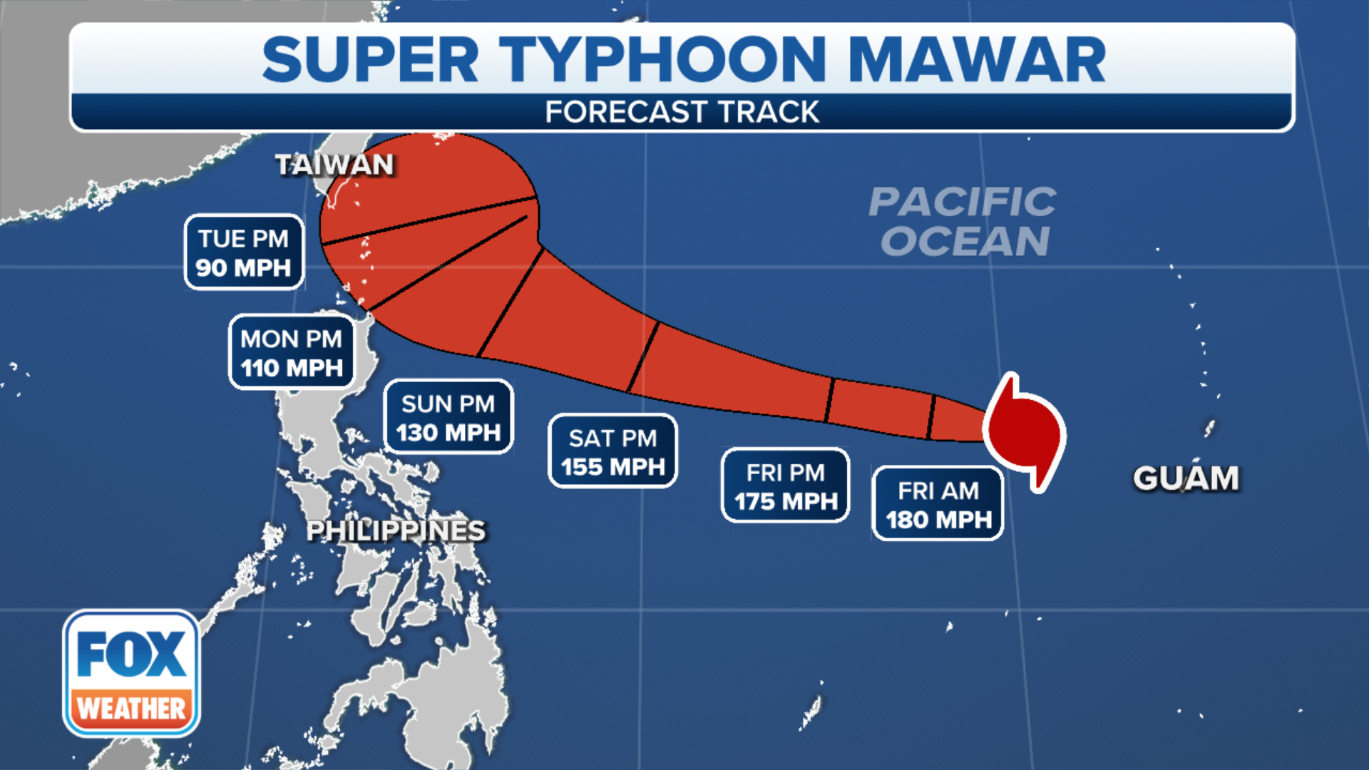
(FOX Weather)
The cyclone is expected to continue on a west-northwest heading through the weekend and could reach the equivalent of a Category 5 on the Saffir-Simpson Hurricane Wind Scale.
The FOX Forecast Center said on the projected path Mawar could approach the northern Philippines or Taiwan by early next week.
It is too early tell which islands could be impacted, and the forecast track will continue to be updated by the Joint Typhoon Warning Center.