Lorena becomes post-tropical cyclone, flood risk remains for Baja California as moisture impacts Southwest US
According to the FOX Forecast Center, some of the tropical moisture from Lorena is now enhancing the seasonal monsoon weather pattern across the Southwest U.S.

Lorena becomes post-tropical but fuels flood threat across US Southwest
Lorena continues to weaken in the Eastern Pacific, its related tropical moisture is being thrown into the Southwestern United States. A flash flood risk increases in coverage by Friday and Saturday. The heaviest rain is expected in Arizona, New Mexico, as well as west and central Texas. This rain would be just southwest of Texas Hill Country, which is still recovering from devastating flooding this past summer. People in Hill Country should remain weather aware this weekend.
Lorena became a post-tropical cyclone Friday morning but is still bringing heavy rain and the risk of life-threatening flash flooding to the Baja California Sur region of Mexico through Friday, according to the National Hurricane Center (NHC).
Heavy rain from then-Hurricane Lorena flooded the Los Cabos community of Mexico and washed away cars and parts of roads beginning on Wednesday. Lorena was downgraded back to a tropical storm Thursday morning and is expected to continue to weaken and dissipate this weekend.
According to the FOX Forecast Center, some of the tropical moisture from Lorena is now enhancing the seasonal monsoon weather pattern across the Southwest U.S., with places in Arizona, New Mexico, Colorado and West Texas expected to receive an additional inch of rain through the weekend.
HOW HURRICANE LORENA WILL HELP BRING INCREASED RAINFALL TO SOUTHWEST US

Rain from Hurricane Lorena floods Los Cabos, Mexico
Heavy rain from Hurricane Lorena flooded Los Cabos, Mexico Wednesday and washed away cars and parts of roads. The Mexican National Guard helped remove debris from streets and even hospitals as the community in Los Cabos, which includes the popular resort city of Cabo San Lucas began to clean up after the heaviest rain from Lorena had passed.
The Mexican National Guard helped remove debris from streets and even hospitals in Los Cabos on Wednesday, which includes the popular resort city of Cabo San Lucas, as people there began to clean up after the heaviest rain from Lorena had passed.
Urban flooding was seen on verified social media accounts from Cabo San Lucas Wednesday morning. The government of Baja California Sur opened shelters and suspended schools and work in five municipalities.

(FOX Weather)
All Tropical Storm Watches and Warnings for Mexico were dropped Thursday evening.
Lorena is currently 170 miles west of Cabo San Lazaro, Mexico. What is left of the storm is expected to now move west, away from land before continuing to weaken.
The NHC expects that 4-8 inches of additional rain could fall across parts of Baja California Sur and far southeastern Baja California through Friday.
Lorena became a hurricane in the Eastern Pacific Ocean Wednesday morning.
WHAT'S THE DIFFERENCE BETWEEN A TROPICAL DEPRESSION, TROPICAL STORM AND HURRICANE?

(FOX Weather)
Moisture from Hurricane Lorena to surge into US Southwest
According to the FOX Forecast Center, abundant atmospheric moisture from Lorena is now surging into the Southwest U.S.
While the heaviest rain is expected across Mexico, parts of Arizona and New Mexico could receive a widespread 1-2 inches of rain, with locally higher amounts possible.

Watch: Waves crash onto Mexican beaches as Tropical Storm Lorena forms in Eastern Pacific
A compilation of videos from Mexican Beaches show gloomy skies after the National Hurricane Center announced the development of Tropical Storm Lorena on Tuesday.
This is a somewhat similar pattern to the heavy rain that fell across parts of Southern California and Nevada last week, which was somewhat enhanced by the moisture from the remnants of Tropical Storm Juliette.
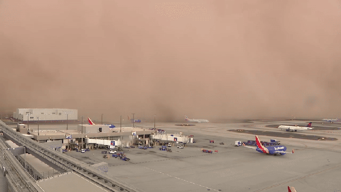
Phoenix also saw a massive dust storm last week, known as a haboob, which is caused by the monsoon weather pattern.
![This animated image shows a dust storm, known as a haboob, sweeping across Phoenix Sky Harbor International Airport on Monday, Aug. 25, 2025.]() Image 1 of 3
Image 1 of 3This animated image shows a dust storm, known as a haboob, sweeping across Phoenix Sky Harbor International Airport on Monday, Aug. 25, 2025. (FOX 10 Phoenix)
![This photo shows a massive dust storm, known as a haboob, sweeping across Phoenix on Aug. 25, 2025.]() Image 2 of 3
Image 2 of 3This photo shows a massive dust storm, known as a haboob, sweeping across Phoenix on Aug. 25, 2025. (@GOPNateJackson/X)
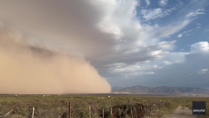
![Arizona Haboob]() Image 3 of 3
Image 3 of 3A massive haboob dwarfed a mountain range in Arizona on Sunday, July 13, amid severe thunderstorm warnings and strong winds. (Lori Grace Bailey via Storyful)

The Eastern Pacific Basin has already had an active start to the season, producing 10 named storms so far, five of them hurricanes, including three that reached Category 3 strength or higher.
BRYAN NORCROSS: COMPUTER FORECASTS SHOW THE ATLANTIC DISTURBANCE DEVELOPING THIS WEEK
Elsewhere in the Pacific Basin, Hurricane Kiko, which reached major status earlier this week, is moving into the Central Pacific Ocean in the general direction of Hawaii.
The Eastern Pacific hurricane season runs from May 15 to Nov. 30.