How Hurricane Lorena will help bring increased rainfall to Southwest
The moisture plume from the storm’s future remnants is expected to stream northward, meaning that communities in southern Arizona, New Mexico and West Texas could be subject to enhanced rainfall chances.

Rounds of tropical moisture expected to spread through the southwest
Hurricane Lorena continues to cause a flash flood threat, as heavy rain rates are expected in upcoming monsoon storms for the southwest.
PHOENIX – A surge of tropical moisture could bring higher humidity values and waves of rainfall late in the week through the weekend to portions of the Desert Southwest as Hurricane Lorena falls apart over northwestern Mexico.
The hurricane, currently off the west coast of central Mexico, is expected to make landfall along the California Baja Peninsula sometime Thursday night into Friday morning.
The moisture plume from the storm’s future remnants is expected to stream northward, meaning that communities in southern Arizona, New Mexico and West Texas could be subject to enhanced rainfall chances.
Computer models vary on the amount of expected precipitation, but the heaviest totals are most likely to fall along and south of the Interstate 10 corridor.
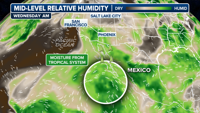
Humidity forecast map.
(FOX Weather)
SOUTHWEST MONSOON SEASON: WHAT YOU NEED TO KNOW
Preliminary forecasts suggest some locations could pick up 1-2 inches of rain through the weekend. Meanwhile, cities that have seen less monsoon activity this year, including Phoenix and Las Vegas, may receive only minimal rainfall directly tied to Lorena.
With the potential of heavy rainfall comes a heightened threat of flash flooding, which is common during the region’s monsoon season.
In addition to the threat of heavy rainfall, the increase in cloud coverage should be substantial enough to hold temperatures down below their norms for the second half of the week.

(FOX Weather)
Forecast models suggest that by the weekend, the prevailing pattern should turn more westerly or northwesterly and cut off the flow of tropical moisture.
This will allow drier weather to return and temperatures to reach near 100 degrees again as the first full week of September gets underway.
So far this year, parts of New Mexico have been on the wetter side of the monsoon pattern, which has failed to propagate westward into Arizona and Nevada.
As a result, many desert communities in the western portion of the region remain well below average in terms of seasonal rainfall.
While there remains time for additional influxes of moisture before the monsoon season officially concludes, most activity typically diminishes by mid-September.
After the monsoon season, a shift towards a drier fall and winter pattern typically begins, with the focus turning to mountain snowfall.
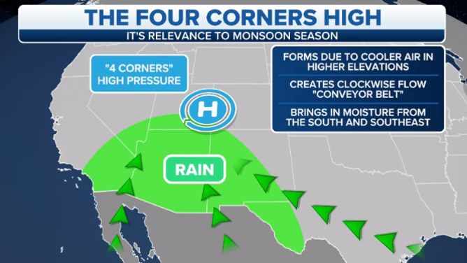
Shown on the map is the typical weather pattern that dominates during much of the North American monsoon season.
(FOX Weather)