Major Hurricane Kiko heads toward Hawaii but expected to weaken in days ahead
Forecast models suggest that Hurricane Kiko will make its closest approach to Hawaii during the early to middle part of next week, but the exact impacts, whether it is an increase in shower activity or heightened waves, remain to be determined.

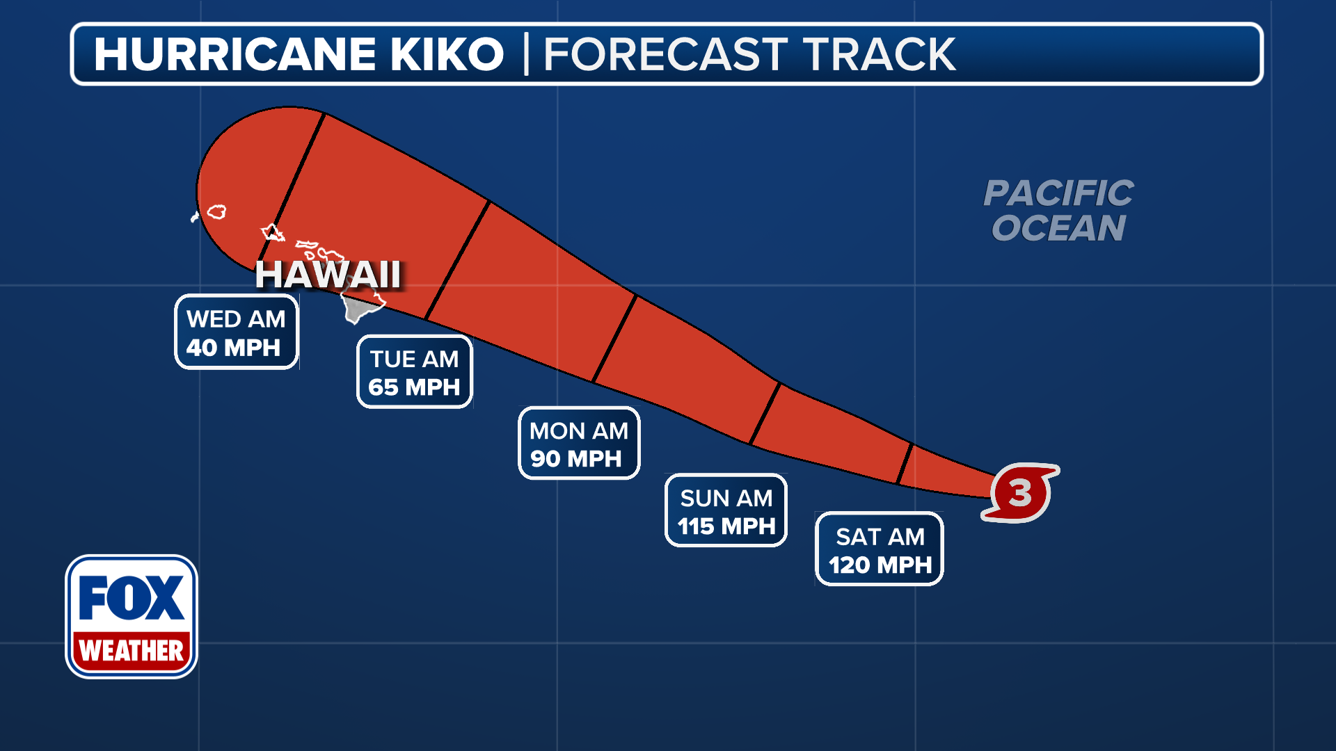
Hawaii eyes Hurricane Kiko which remains a major Category 3 storm
While Hurricane Kiko remains small, it’s a quiet powerful storm. Kiko remains over warmer waters for a short time and further strengthening may occur. Some forecast models have Kiko reaching Category 5 before a very quick weakening trend. Current forecast has Kiko traversing over cooler water temperatures and it would be a tropical storm by the time it reaches the vicinity of the Big Island early next week. Because Kiko has a small footprint, even a slight shift in its track could greatly affect how it impacts the islands.
HONOLULU – Hurricane Kiko weakened slightly Friday morning and is now a Category 3 storm in the central Pacific Ocean as it treks toward the west in the general direction of Hawaii, with the risk of direct rain and wind impacts increasing.
The National Hurricane Center reported that the major hurricane was more than 1,300 miles east of Hilo, but dry air and cooler water temperatures were expected to act as a significant barrier between the cyclone and the islands.
The NHC said that Kiko could strengthen again later Friday before beginning to weaken as it encounters colder water.
The Hurricane Center did note Friday that swells generated by Hurricane Kiko could begin reaching Hawaii toward the end of this weekend, which could cause life-threatening surf and rip currents.

Hurricane Kiko in the Pacific about 1,400 miles away from Hawaii.
(NOAA)
NWS forecasters in Honolulu noted that cyclones often weaken as they approach the islands due to cooler waters and wind shear.
Forecast models suggest that the cyclone will make its closest approach to Hawaii during the early to middle part of next week, but the exact impacts, still remain to be determined.
"The risk of direct impacts from wind and rainfall is increasing. However, it is too soon to determine the exact location or magnitude of these impacts," the NHC said.
NWS Honolulu forecasters said rain will potentially increase this weekend over parts of the state ahead of Kiko's passage.
"While a large amount of uncertainty exists, there may be a possible threat for high rainfall that could lead to flooding in association with Kiko," the NWS said.
(FOX Weather)
HURRICANE INIKI 30 YEARS LATER: HOW A MONSTER STORM IN HAWAII IMPACTED FILMING OF JURASSIC PARK
Satellites estimate that sea surface temperatures between the hurricane and the Big Island of Hawaii are in the mid-70s, which is considered to be cooler than what a cyclone typically needs for strengthening.
Hurricane experts widely consider water temperatures of at least 79 degrees to be warm enough for storm systems to organize and strengthen.
Hawaii tropical landfalls are rare
Officials in Hawaii are accustomed to closely monitoring tropical systems, but direct landfalls are rare, primarily because of the sea surface temperatures.
Data from NOAA shows only four major hurricanes with winds of at least 115 mph passing within 50 miles of the 137 Hawaiian Islands.
In August 2021, the remnants of Hurricane Linda passed directly over parts of the state after the system weakened into a non-trackable entity.

(FOX Weather)
The remnants produced heavy rainfall on some islands, with elevated waves on north and east-facing beaches.
In 2020, Hurricane Douglas came even closer, and triggered the issuance of watches and warnings, but still did not make a direct landfall.
7 FACTS TO KNOW ABOUT HURRICANES
On average, Hawaii experiences outer fringe impacts from a tropical cyclone every year or two, but the amount of activity is usually dependent on the status of the El Niño Southern Oscillation, or what is commonly referred to as the ENSO.

Hawaii tropical setup.
(FOX Weather)
According to NOAA’s hurricane database, the impact rate of hurricanes on the islands is lower during La Niña events and substantially higher during what are considered to be either neutral or El Niño years.
Similar to the Atlantic basin hurricane season, cyclone activity in the central Pacific tends to peak during the August-October timeframe, before coming to an end in November and December.