Dangerous severe weather targets millions across the Plains, Midwest with damaging winds, hail
Over 74 million Americans are in the threat zone Saturday, with a dangerous mix of damaging winds, large hail, a few tornadoes and flash flooding all possible.
Damaging winds target Plains, Midwest as millions face dangerous severe weather threat
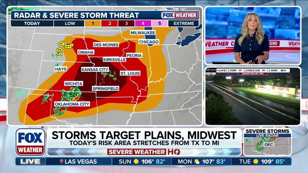
Dangerous storms target the Plains Saturday, stretching from Missouri to Texas. Damaging winds and large hail will be the main threats, but a few tornadoes will be possible, with a Level 3/5 severe threat issued for parts of the region. Full Forecast:
A surge of tropical moisture is triggering an active weather pattern across the central and southern U.S. this weekend.
The multi-hazard threat kicks off Saturday, bringing a significant risk of severe storms and heavy rainfall capable of producing widespread flash flooding.
(FOX Weather)
This threat comes on the heels of a severe weather outbreak that tore across the Plains and Midwest, leaving widespread damage and power outages in more than ten states. The storm system unleashed destructive winds and spawned numerous confirmed tornadoes across the region.
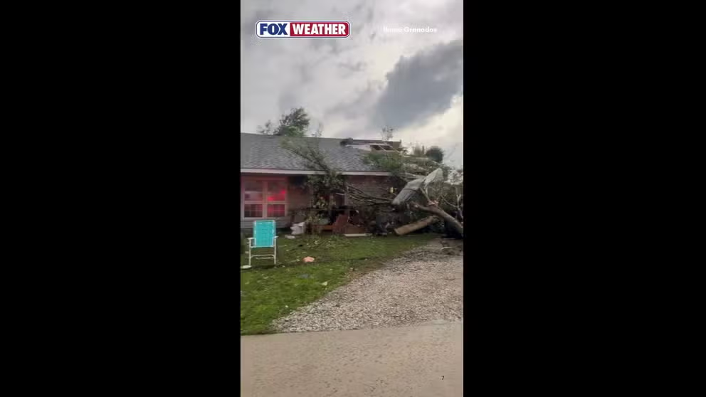
Tornado causes path of devastation in Illinois community
A tornado ripped through Streator, Illinois, on Thursday night, leaving behind a path of destruction.
WIDESPREAD DESTRUCTION: TORNADOES CAUSE CATASTROPHIC DAMAGE IN ILLINOIS AND INDIANA COMMUNITIES
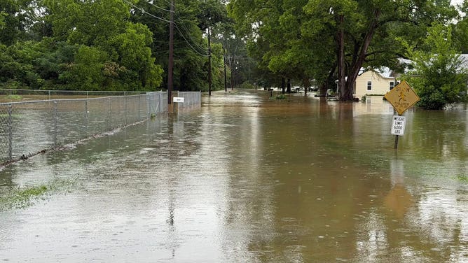
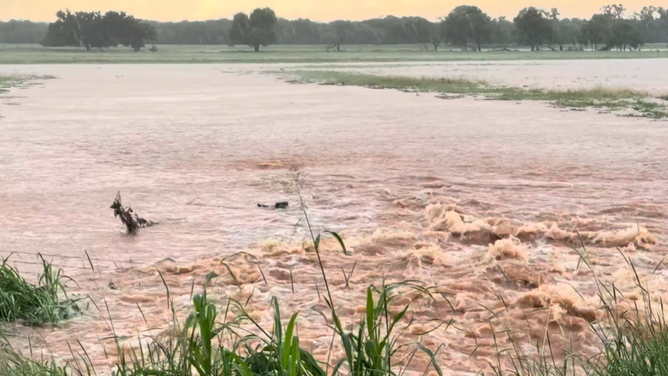
Compounding the threat, the system also follows life-threatening flash flooding that recently targeted the central and southern U.S., inundating homes and structures, and triggering multiple water rescues.
![First responders in and around Huntsville also conducted multiple water rescues of drivers trapped on flooded local roads.]() Image 1 of 4
Image 1 of 4First responders in and around Huntsville also conducted multiple water rescues of drivers trapped on flooded local roads on Sunday, June 7, 2026. (Moores Mill Vol. Fire Rescue/Facebook)
![Heavy downpours prompt emergency rescues across parts of Central Texas Saturday.]() Image 2 of 4
Image 2 of 4Heavy downpours prompt emergency rescues across parts of Central Texas Saturday, June 6. (@TexasGameWarden / X)
![Floodwaters inundate neighborhood in Hollywood, Alabama, on Sunday, June 7, 2026.]() Image 3 of 4
Image 3 of 4Floodwaters inundate neighborhood in Hollywood, Alabama, on Sunday, June 7, 2026. (Hollywood Fire & Rescue)
![Thunderstorms cause flooding in Fairview, Oklahoma on Friday, June 5, 2026.]() Image 4 of 4
Image 4 of 4Thunderstorms cause flooding in Fairview, Oklahoma on Friday, June 5, 2026. (Phillip McGee via Storyful)


Over 74 million Americans are in the threat zone Saturday, with a dangerous mix of damaging winds, large hail, a few tornadoes and flash flooding all possible.
Renewed severe weather threats loom for the Central U.S.
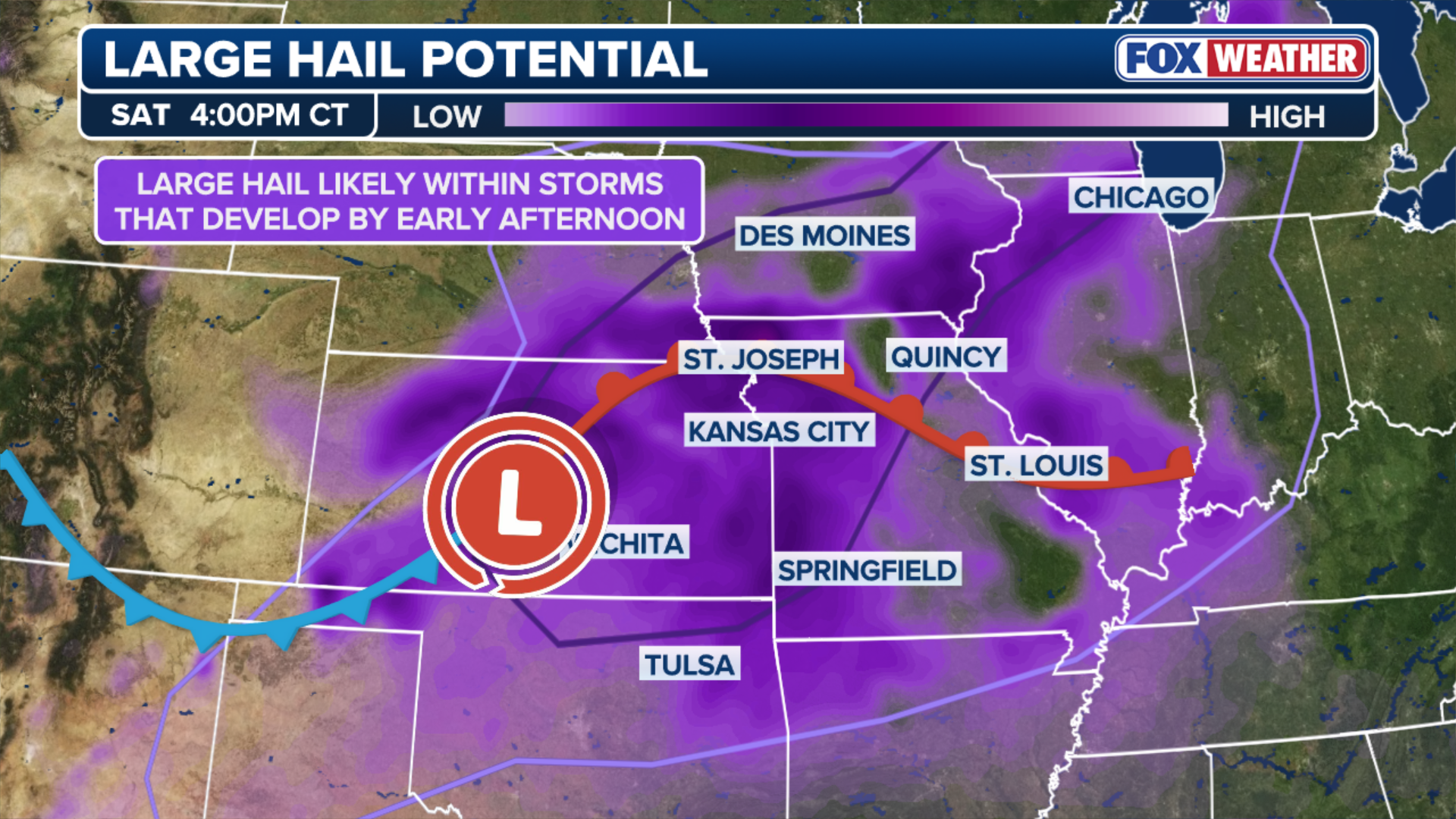
Thunderstorms will bring renewed potential for damaging winds and large hail on Saturday, prompting the Storm Prediction Center to outline a Level 3 out of 5 risk of severe weather.
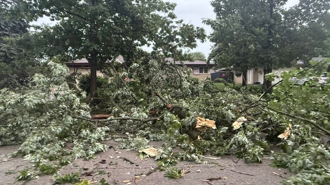
Multiple downed power lines and trees across Joliet, IL, as severe weather impacts the city.
(@JolietWeather/X / FOX Weather)
Additionally, heavy rain is expected, particularly over the Kansas City metropolitan area and its surroundings.
Rainfall will have the potential to produce numerous instances of flash and urban flooding. Consequently, a Level 3 out of 4 risk of flash flooding has been introduced.

Severe weather risk for the Plains Saturday night.
(FOX Weather)
As afternoon temperatures climb, daytime heating will interact with a moisture-rich air mass over Kansas and Missouri. Leftover outflow boundaries from morning showers will serve as the primary trigger for a fresh round of intensifying storms.
"Expect organized storm clusters and potentially a few supercells to fire up, bringing a renewed threat of large hail and damaging winds," the FOX Forecast Center said.
However, the more intense action will likely initiate a bit further west, stretching from the Central Plains down into the Lower Missouri Valley.
Strong daytime heating ahead of the low-pressure system will combine with rich low-level moisture and steep lapse rates aloft to create a highly unstable, "powder keg" environment.
With roughly 40 knots of effective shear available, this environment is prime for scattered, semi-discrete supercells to erupt. These initial standalone storms will carry a significant threat for large hail and localized severe wind gusts.
(FOX Weather)
As the cold front begins to sweep southeastward later in the day, it will force even more storm development.
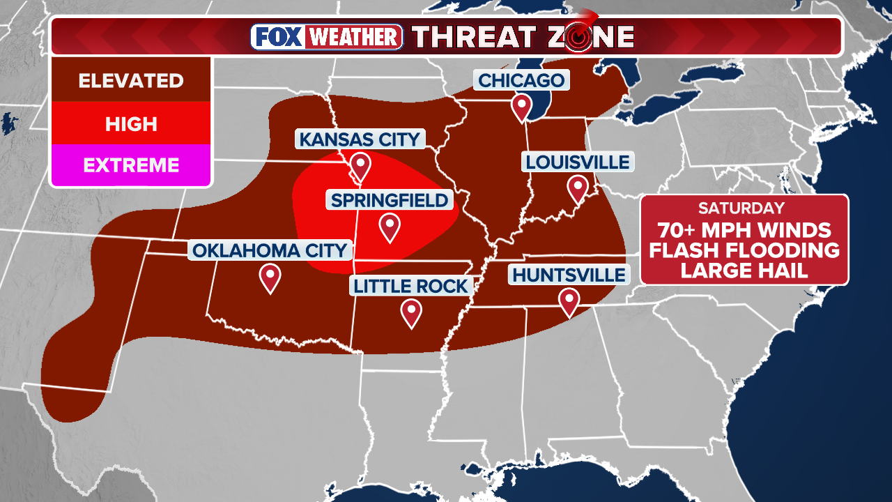
Those scattered supercells are expected to merge and grow upscale into intense, organized clusters or a squall line. As this massive complex surges east-southeastward through a corridor of extreme instability, the primary severe threat will transition to widespread, damaging wind gusts—some potentially exceeding 75 mph.
Attached to the severe threat will be the risk of flash flooding.

(FOX Weather)
Any storm that develops will have rain rates between 2 and 3 inches per hour, with higher intra-hour rates likely exceeding 4 inches at times, especially as you get further south into southeastern Kansas and southern Missouri where instability will be maximized.
The worst of the rain will occur Saturday night. Over 3 inches of rain is likely to fall, and localized amounts could easily exceed 8 inches, the FOX Forecast Center said.
Tropical moisture fuels widespread storm threats across the South
By Saturday afternoon, an area of low pressure will begin to move out of the Rockies and intensify as it moves into the Central Plains.
Extending from this area of low pressure will be a cold front draped from Kansas through Texas, along with a warm front stretching north into the Great Lakes.
In the warm sector, south of the warm front, hot temperatures accompanied by high humidity, will increase instability, with steep mid-level lapse rates overspreading the region.
As a result, storms will begin to develop during the afternoon and persist into the overnight hours.
OVER 400K RESIDENTS WITHOUT POWER IN THE MIDWEST AFTER DESTRUCTIVE DERECHO SLAMMED THE REGION
As this area of low pressure moves toward the Northeast, the trailing cold front will slow down, extending from the Great Lakes into northern Texas by Sunday and Monday.

Texas Game Wardens, along with the SAR team, carry residents out of rising floodwaters in Central Texas Saturday, June 6.
(@TexasGameWarden / X)
SUMMER HEAT, APPROACHING COLD FRONT FUEL INCREASED MULTIDAY SEVERE STORM THREAT IN THE NORTHEAST
South of this front, strong southerly flow will pull Gulf moisture into the Deep South that was previously associated with the area of interest in the Bay of Campeche.
Due to the increased tropical moisture and instability, periods of heavy rain and thunderstorms are likely through the end of the weekend and into next week.
14 SAVED FROM FLOODED ALABAMA CAVES DURING FLASH FLOOD EMERGENCY
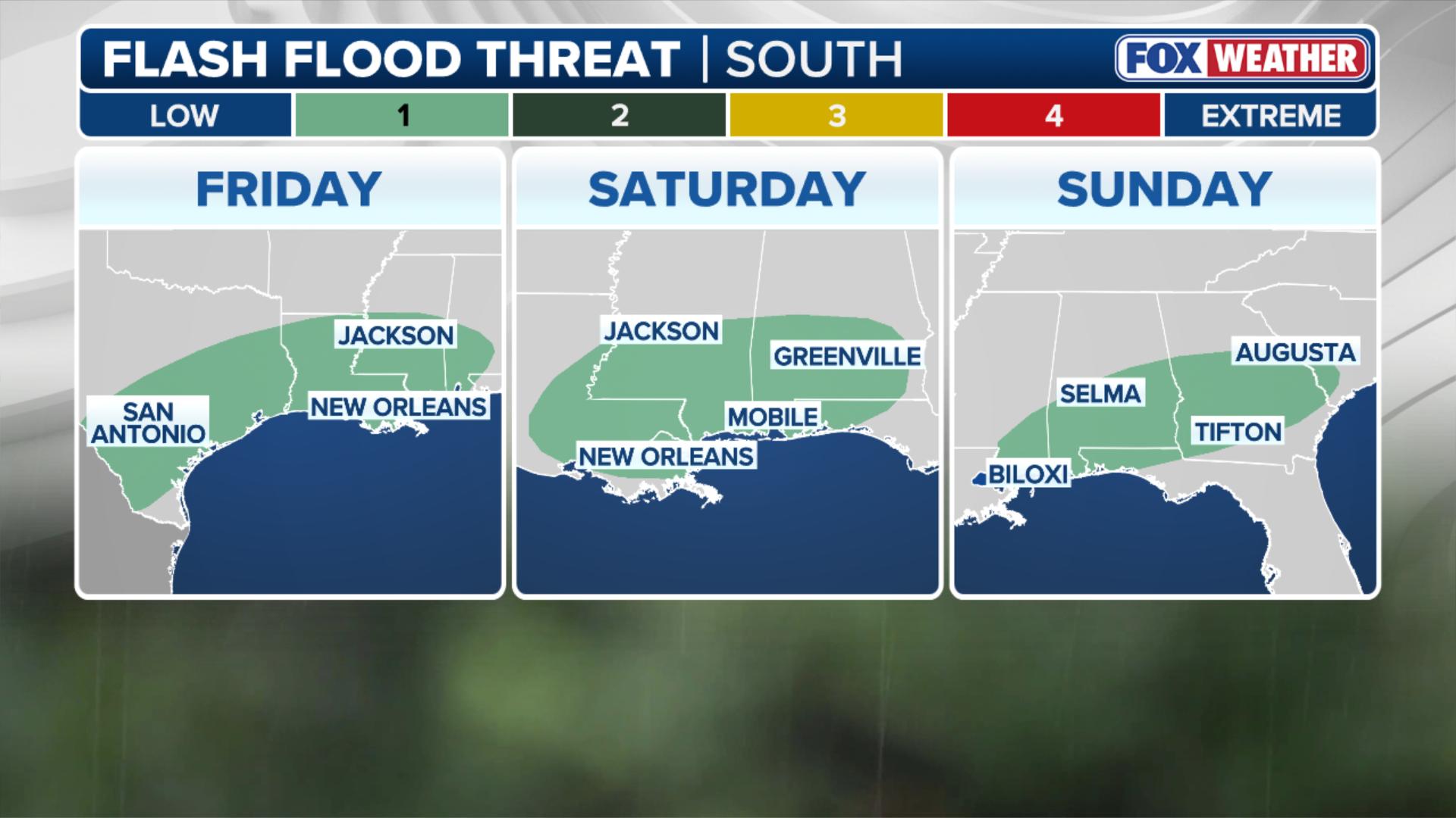
This has prompted a Level 2 out 4 flash flood risk is in place for both Saturday and Sunday across Oklahoma, Texas, Missouri, Louisiana, and Mississippi.

(FOX Weather)
Through early next week, widespread rainfall totals of 2 to 3 inches are possible from Texas through Tennessee, with localized amounts of about 5 inches or more.
(FOX Weather)
With outlooks showing this front stalling, producing multiple rounds of rain continuing into the middle of next week, the risk of flash flooding will likely persist and may expand, the FOX Forecast Center said.