See it: Days of torrential rain drench Central, Southern US, triggering flash floods and water rescues
Rainfall rates dropped anywhere from 2 to to even 6 inches per hour at times, flooding homes and leaving people stranded on the tops of cars.

Watch: Torrential rain inundates southern Indiana, turns Lanesville street into river
Heavy downpours swell Little Indian Creek, leaving this street in Lanesville flowing like a river and forcing floodwaters into structures Tuesday as 8 inches of rain inundated the area.
Nearly a week of downpours has dumped inches of rain across portions of the Central and Southern U.S., triggering life-threatening flash flooding and multiple water rescues.
14 SAVED FROM FLOODED ALABAMA CAVES DURING FLASH FLOOD EMERGENCY
Millions were under some type of flood alert as many were placed in the Level 2 out of 4 flood threat.
Firefighters work on multiple water rescues in Columbus, Kansas Monday.
(COLUMBUS, KS FIRE RESCUE/FACEBOOK)
Over the course of six days, several areas recorded over 5 inches of rain, while parts of Texas surpassed 9 inches.

Heavy downpours prompt emergency rescues across parts of Central Texas Saturday.
(@TexasGameWarden / X)
Rainfall rates dropped anywhere from 2 to even 6 inches per hour at times, flooding homes and streets, with some people stranded on the tops of cars.
KNOW YOUR FLOOD TERMINOLOGY: WHAT FLOOD WATCHES, WARNINGS AND EMERGENCIES REALLY MEAN
On Tuesday, over 2 inches of rain drenched Jordan-Hare Stadium in Auburn, Alabama, just hours before a pre-World Cup "friendly fixture' between Argentina and Iceland.
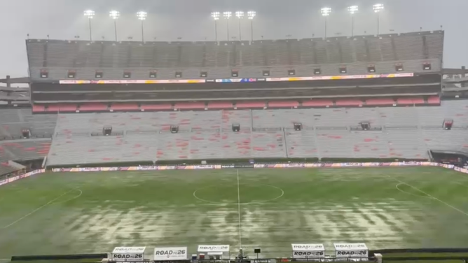
Heavy rain floods Jordan-Hare Stadium in Auburn Alabama Tuesday.
(Albert Mendiola via Storyful)
Fortunately, the field dried out in time for the match to be played.
On Monday, water rescues were reported near Joplin, Missouri, as rain fell at an extreme rate of 4 inches per hour amid active life-threatening flash flooding.
According to Missouri Flash Flooding and Stranded Motorists Rescues, rescue calls came in reporting two people stranded on top of their vehicle due to rising waters, alongside reports of at least two flooded homes.
KNOW YOUR FLOOD TERMINOLOGY: WHAT FLOOD WATCHES, WARNINGS AND EMERGENCIES REALLY MEAN
Additionally, heavy rain began pounding the region Thursday, leaving roads swamped and prompting emergency rescues over the weekend.

Watch: Drone video shows parts of Jackson County, Alabama, inundated during Flash Flood Emergency
Drone video shows parts of Jackson County, Alabama, inundated during Flash Flood Emergency
A Flash Flood Emergency was in effect Sunday after 5 to 9 inches of rain fell across parts of Jackson and Madison counties in Alabama.
The National Weather Service (NWS) received reports of water rescues, flooded streets and homes in and around Huntsville, Alabama.
Images from Hollywood, Alabama, 45 miles east of Huntsville, showed an inundated neighborhood Sunday afternoon.
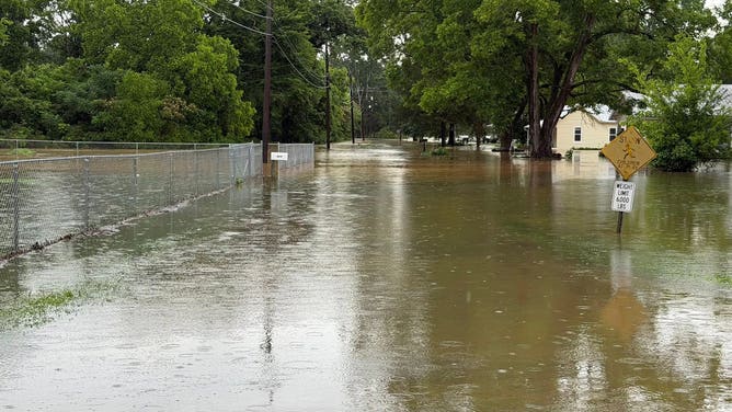
Floodwaters inundate neighborhood in Hollywood, Alabama, on Sunday, June 7, 2026.
(Hollywood Fire & Rescue / FOX Weather)
Along with that, rescuers saved 14 people from flooded caves during two separate incidents in northern Alabama during the Flash Flood Emergency in Jackson County.

Rescuers saved 14 people from flooded caves during two separate incidents in northern Alabama during a Flash Flood Emergency in Jackson County Sunday afternoon.
(Huntsville Cave Rescue Unit, Inc./Facebook)
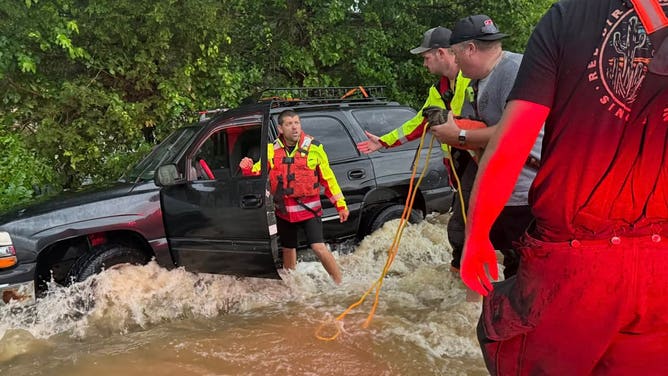
Over the weekend, torrential rain pounded parts of Central Texas.
7 FACTS YOU SHOULD KNOW ABOUT FLASH FLOODS
Texas Game Wardens said they responded to flood calls across Bell, Falls, McLennan and Milam counties, rescuing at least nine people between Friday and Saturday.
![Texas Game Wardens, along with the SAR team, carry residents out of rising floodwaters in Central Texas Saturday.]() Image 1 of 3
Image 1 of 3Texas Game Wardens, along with the SAR team, carry residents out of rising floodwaters in Central Texas Saturday. (@TexasGameWarden / X)
![Texas Game Wardens, along with the SAR team, carry residents out of rising floodwaters in Central Texas Saturday.]() Image 2 of 3
Image 2 of 3Texas Game Wardens, along with the SAR team, carry residents out of rising floodwaters in Central Texas Saturday. (@TexasGameWarden / X)
![Heavy downpours prompt emergency rescues across parts of Central Texas Saturday.]() Image 3 of 3
Image 3 of 3Heavy downpours prompt emergency rescues across parts of Central Texas Saturday. (@TexasGameWarden / X)


Slow-moving storms amplified the downpours, repeatedly drenching the same locations at times.
The flash flood threat in this region should finally diminish on Wednesday and Thursday.