Weekend flash flood threat lingers in Florida as tropical moisture streams over Sunshine State
Florida is experiencing a tale of two states this year, with some of the driest conditions on the Gulf Coast and the wettest on the east coast. Part of the Atlantic coast could see up to 8 inches of rain through Tuesday as a stalled cold front and weak area of low pressure create heavy rain and breezy conditions.

Flood watches continue for Florida after days of rain
Hurricane Imelda left behind tropical moisture, creating flood dangers for much of Florida’s east coast. FOX Weather Correspondent Brandy Campbell reports from Daytona Beach, where high tides, rip currents and big waves are creating dangerous beach conditions.
MIAMI – After being spared from back-to-back hurricanes, Florida will continue to see the potential for flooding rain through the weekend and to start the workweek as tropical moisture streams toward the Sunshine State.
According to the FOX Forecast Center, former hurricanes Imelda and Humberto have left conditions in the Atlantic ripe for a persistent rainy and windy pattern throughout the Southeast. Tropical moisture and a stalled cold front across Florida will create widespread rainfall and an increased risk of flash flooding.
The National Hurricane Center (NHC) is tracking Invest 95L in the Atlantic, which is likely to become the next tropical depression this season. The NHC is also watching an area of disturbed weather in the Gulf that has a near-zero chance of tropical development but is bringing much-needed rain to cities along Florida's Gulf Coast.
![Sunrise in Daytona Beach on Sunday, October 5, 2025.]() Image 1 of 3
Image 1 of 3Sunrise in Daytona Beach on Sunday, October 5, 2025. (Brandy Campbell)
![Sunrise in Daytona Beach on Sunday, October 5, 2025.]() Image 2 of 3
Image 2 of 3Sunrise in Daytona Beach on Sunday, October 5, 2025. (Brandy Campbell)
![Sunrise in Daytona Beach on Sunday, October 5, 2025.]() Image 3 of 3
Image 3 of 3Sunrise in Daytona Beach on Sunday, October 5, 2025. (Brandy Campbell)


Persistent rain will build the flooding threat through the weekend, peaking on Monday.
NOAA's Weather Prediction Center has issued a Level 1 out of 4 flash flood threat through Monday for parts of Florida’s Atlantic coast.

(FOX Weather)
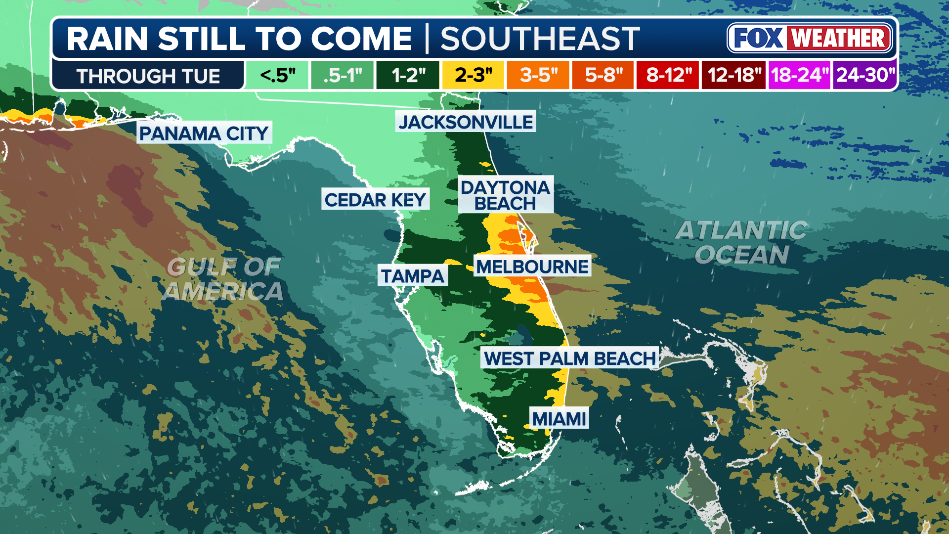
Widespread rain totals could reach between 3 and 5 inches on the state's east coast, with isolated totals reaching 5 inches through Tuesday along the Atlantic coastline. Florida's Treasure, Space and First coasts will see some of the highest rain totals for the state, according to current models.
(FOX Weather)
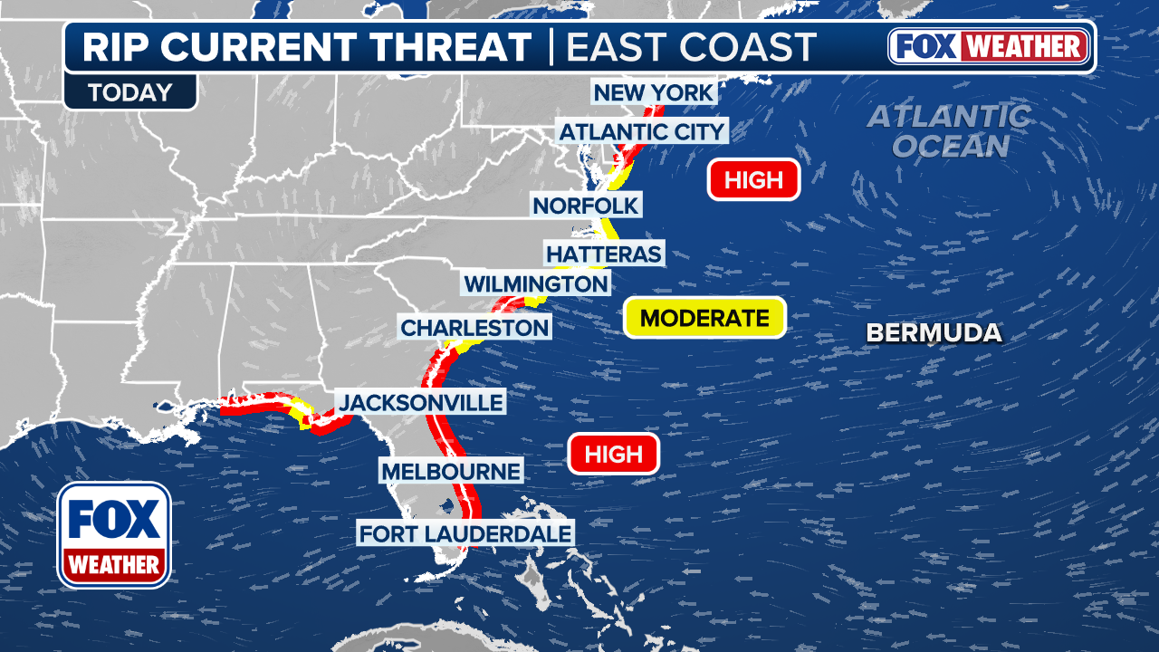
Additionally, persistent onshore flow may also elevate the risk of coastal flooding in low-lying areas and enhance the danger of rip currents.
The rip current threat remains high for much of the U.S. East Coast, ending the weekend after back-to-back storms in the Atlantic.
(FOX Weather)
All this talk of rain makes it a good time to mention that not all the Sunshine State has been turned into the rainy state this fall. Florida is experiencing a tale of two states this year, with some of the driest conditions on the Gulf Coast and the wettest on the east coast.
With a slower start to the Atlantic hurricane season, Florida's west coast is having a dry run.
"The only thing you could hypothesize, if something does develop, moves over the Florida Peninsula, then it gets into the Gulf, then you might get some moisture, but there's a very low chance that that happens," FOX Weather Meteorologist Stephen Morgan said.
The area the NHC is watching in the Gulf could help with some rain for Florida's west coast. The current forecast shows the majority of the rain will be in the Panhandle region.
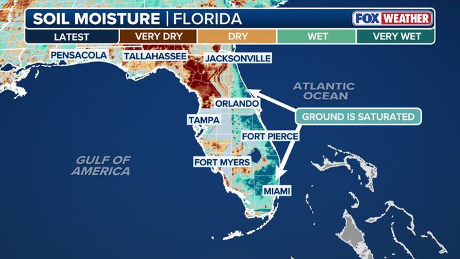
A graphic showing Florida's current soil moisture differences on the east and west coasts.
(FOX Weather)
Tampa saw its driest September on record with under an inch of rain throughout the month. Tallahassee experienced its third-driest September with just over a half-inch of rain. Meanwhile, on the opposite side of the state, Miami saw 16.52 inches, its third-wettest September on record, and Daytona Beach received more than a foot of rain, marking its 10th-wettest September.