Invest 91L odds of development drop as peak of hurricane season approaches
The Hurricane Center said 91L is now in an area where environmental conditions will likely cap its development over the next 48 hours.
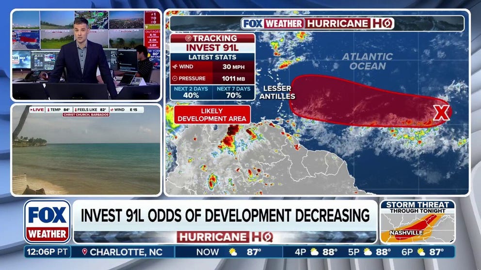
Invest 91L development odds dropping
Dry air around Invest 91L is creating an environment that is not conducive for tropical development over the next two days.
MIAMI – Odds are now dropping that a Tropical Depression Seven or even Tropical Storm Gabrielle will develop sometime this weekend from Invest 91L, which is slowly making its way west across the Main Development Region of the Atlantic Ocean.
Invest 91L is currently located in the eastern tropical Atlantic, according to the National Hurricane Center (NHC).
The NHC said in its early Friday afternoon update that 91L is now in an area where environmental conditions will likely cap its development over the next 48 hours.
However, they noted that 91L could still develop into a tropical depression early next week as the system moves westward at around 10 mph.

(FOX Weather)
"A tropical depression is a low bar. It just means that the system has developed an organized circulation," says FOX Weather Hurricane Specialist Bryan Norcross. "As it moves slowly west, it will be plowing through patches of dusty air, which will likely keep it from intensifying quickly, and the dry air could do it in."
WHAT’S THE DIFFERENCE BETWEEN A TROPICAL DEPRESSION VS. TROPICAL STORM VS. HURRICANE?
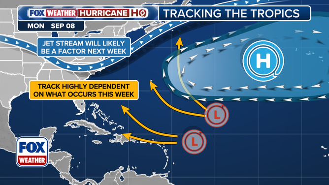
The FOX Forecast Center said that the steering currents are weak across the tropical belt, so it may take about a week until the system is in the vicinity of the Caribbean islands.
While confidence is still high that a tropical system will eventually form over the next week, its track and strength remains an open question.
"The upper winds are forecast to be conducive to development, but the persistent dry, dusty air and the disturbance’s slow forward movement are deterrents to strengthening. How those factors balance accounts for the uncertainty," Norcross said.
In the long range, the FOX Forecast Center said that computer forecast models remain split.
This graphic shows the potential setup for a tropical disturbance in the Atlantic.
(FOX Weather)
Some of them are showing a weak disturbance continuing to the west, and others predict the system will develop into Hurricane Gabrielle and then make a turn to the north.
"Because there are so many moving parts, the long-range forecast is extra murky," Norcross said. "This is not surprising given the forecasting rule that forecasts for systems that are disorganized, just developing, and/or moving slowly are subject to large errors and are likely to change."
At this time, it appears as though a strong dip in the jet stream will be reinforced across the eastern U.S., which should continue to deflect any strong storms to the north.
However, the FOX Forecast Center said that the jet stream has much less steering effect on weaker systems.
"Our exclusive Tropical Threat analysis of the European, U.S. GFS, and Google DeepMind models shows that the system is likely to track in the direction of the northeast Caribbean, but notice that the odds of at least a tropical depression existing at that point are significantly lower, Norcross said. "That's because the possible tracks for the storm spread out, but also because many of the models weaken the system or dissipate it."
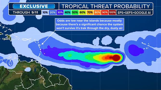
(FOX Weather / FOX Weather)
"The takeaway from that graphic (above) is that the most likely path for the system and possibly Tropical Storm Gabrielle is toward the northeast Caribbean," Norcross added. "But there is high uncertainty in the exact track and the intensity of the system, and it might not survive."
Be sure to download the free FOX Weather app to keep up with developments of this tropical disturbance.