Bryan Norcross: Tropical disturbance showing some signs of development on a track toward the Caribbean
The computer forecast models are all over the place as to what's going to happen over the next week. A number of models dissipate the system before the islands. Others say the system could turn into a significant hurricane next week.
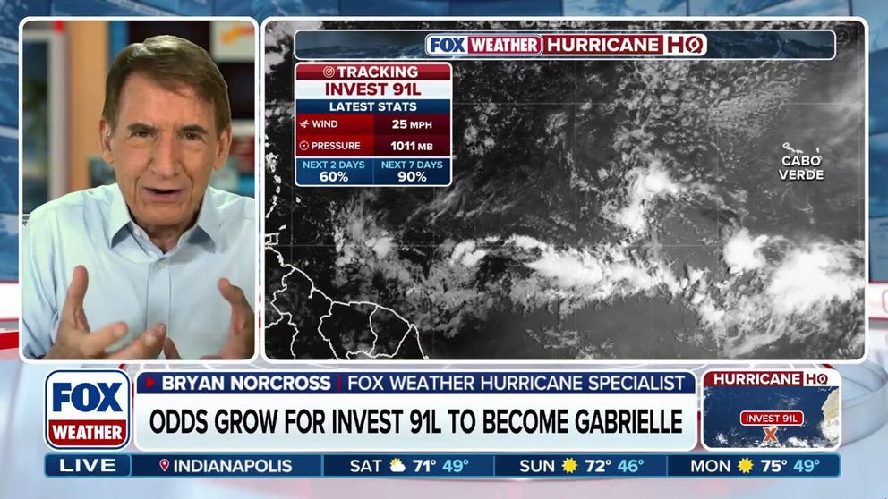
Bryan Norcross: More questions surround Invest 91L in the Atlantic Ocean
FOX Weather Hurricane Specialist Bryan Norcross says the computer forecast models are all over the place as to what's going to happen over the next week with regard to Invest 91L in the Atlantic Ocean. A number of models dissipate the system before the islands. Others say the system could turn into a significant hurricane next week.
The disturbance in the tropical Atlantic, designated Invest 91L by the National Hurricane Center, is showing signs of organization. The NHC is still painting a large potential development area, however, because exactly when the system will become a tropical depression is still quite uncertain. If that ever happens.
The NHC's odds of development are very high, but that's become less certain as the system has lollygagged in the dry air.
A tropical depression is a low bar. It just means that the system has developed an organized circulation. As it moves slowly west, it will be plowing through patches of dusty air, which will likely keep it from intensifying quickly, and the dry air could do it in. If it does organize and the winds reach 40 mph, it will be named Tropical Storm Gabrielle.
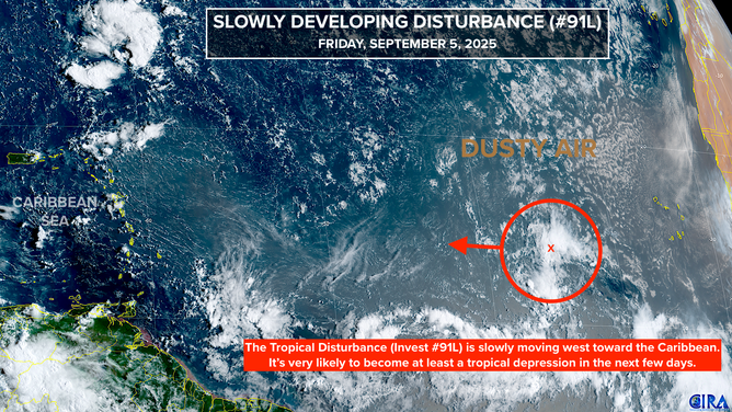
This is satellite imagery of Invest 91L.
(CIRA)
The computer forecast models are all over the place as to what's going to happen over the next week. A number of models dissipate the system before the islands. Others say the system could turn into a significant hurricane next week.
The upper winds are forecast to be conducive to development, but the persistent dry, dusty air and the disturbance’s slow forward movement are deterrents to strengthening. How those factors balance accounts for the uncertainty.
Because there are so many moving parts, the long-range forecast is extra murky. This is not surprising given the forecasting rule that forecasts for systems that are disorganized, just developing, and/or moving slowly are subject to large errors and are likely to change.
That rule is playing out in reality with this system. If you've been watching the long-range computer forecasts, you've seen them switch from out to sea to dissipating to threatening Florida or the Southeast. No long-range forecast for a system that has not yet developed is worth looking at.
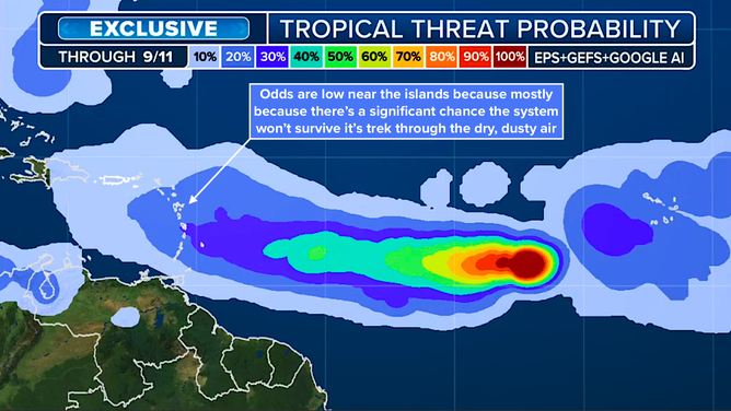
(FOX Weather)
Our exclusive Tropical Threat analysis of the European, U.S. GFS, and Google DeepMind models shows that the system is likely to track in the direction of the northeast Caribbean, but notice that the odds of at least a tropical depression existing at that point are significantly lower. That's because the possible tracks for the storm spread out, but also because many of the models weaken the system or dissipate it.
It's the density of the possible storm tracks that creates the odds. So if there are many tracks from multiple models, the odds are high. But if the tracks spread out or disappear, the odds decrease.
The takeaway from that graphic is that the most likely path for the system and possibly Tropical Storm Gabrielle is toward the northeast Caribbean, but there is high uncertainty in the exact track and the intensity of the system, and it might not survive.
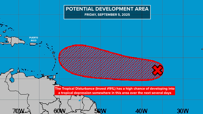
This graphic shows an overview of the tropical Atlantic Basin.
(Bryan Norcross)
How about in Florida?
Everybody in Florida and all along the East Coast that has seen a threatening-looking hurricane model obviously wants to know if that possibility is real. Yes, it's imaginable. But the odds are much much higher of something else happening. It's just too far in the future—more than 10 days—to say anything more.
For now, especially in the islands, this is a time to stay informed. Forecasts should improve when and if the system develops an organized circulation. That looks reasonably likely to happen over the weekend.
GULF COULD CREEP BACK TO LIFE AS PEAK OF HURRICANE SEASON FAST APPROACHES
In the Pacific
The system that was Tropical Storm Lorena is spreading moisture across northern Mexico and into the southwest U.S. Pay attention to local alerts. Flooding is possible.
Hurricane Kiko is still charging in the general direction of Hawaii. The storm is likely to peak in intensity today. Over the weekend it will be transiting much cooler water, and is forecast to begin weakening.
HAWAII TURNS WATCHFUL EYE TO HURRICANE KIKO AS STORM TRACKS TOWARD ISLANDS
On the current schedule, the system will be in the vicinity of the Big Island about Tuesday. It will likely be a tropical storm at that time.
Because the circulation is small, and even the Big Island is a relative speck in the vastness of the ocean, a slight deviation in Kiko's track will make a dramatic difference in the weather that impacts Hawaii. We won't really have a good idea about that until the storm gets closer, but right now, the consensus if that Kiko’s center will pass just north of the islands with most of the moisture and wind offshore.
For now, just stay up-to-date on the latest forecasts.