Hawaii turns watchful eye to Hurricane Kiko as storm returns to Category 4 strength
While the islands are in the five-day forecast cone, meteorologists said that Kiko will be a completely different storm by the time it approaches Hawaii early next week.

Hurricane Kiko regains Category 4 strength in the Pacific
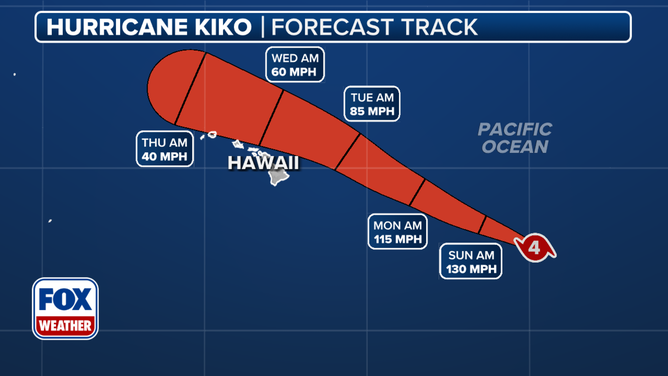
Hurricane Kiko zoomed back up to 130 mph peak wind speeds Friday afternoon as it sat some 1,200 miles east of Hawaii, but the storm is expected to weaken considerably before it reaches close to the state.
HONOLULU - Hurricane Kiko found a second wind Friday afternoon and reintensified into a major Category 4 storm as the storm swirled about 1,200 miles east of Hawaii – though its long-range prospects are still for it to weaken considerably before the cyclone would get close to land.
Still, forecasters and residents are keeping a keen eye on how the storm will play out for Hawaii.

Hurricane Kiko latest stats
(FOX Weather)
Kiko's peak winds jumped back to 130 mph Friday afternoon after dipping to a 115 mph, Category 3 storm Friday morning. But while the islands are in the five-day forecast cone, meteorologists said that Kiko will be a completely different storm by the time it approaches Hawaii early next week as the storm will commence a significant weakening process over the weekend.
Several factors, including cool sea surface temperatures, hostile upper-level winds and dry air, will in essence act as a barrier between the hurricane and the islands. This will likely mean limited impacts for Hawaii.
The current forecast track of Kiko.
(FOX Weather)
HURRICANE INIKI 30 YEARS LATER: HOW A MONSTER STORM IN HAWAII IMPACTED FILMING OF JURASSIC PARK
Satellites estimate that sea surface temperatures between the hurricane and the Big Island of Hawaii are in the mid-70s, which is considered cooler than what a cyclone typically needs for strengthening.
Hurricane experts widely consider water temperatures of at least 79 degrees to be warm enough for storm systems to organize and strengthen.
Based on the forecast cone, rough seas and occasional showers look to be nearly a guarantee, with the possibility of increasing impacts if the cyclone were to take a more southern route.

Sea surface temperatures along the forecast track of Kiko.
Forecasters and computer models should get a better handle on the synoptic scenario after Hurricane Hunters sample the storm on Sunday.
Kiko is a rather small cyclone, with hurricane-force winds only extending outward 25 miles and tropical-storm-force winds extending outward up to 70 miles, meaning that chances are fairly low that Hawaii will see damaging impacts.
"Because the circulation is small, and even the Big Island is a relative speck in the vastness of the ocean, a slight deviation in Kiko's track will make a dramatic difference in the weather that impacts Hawaii," said FOX Weather Hurricane Specialist Bryan Norcross. "We won't really have a good idea about that until the storm gets closer, but right now, the consensus if that Kiko’s center will pass just north of the islands with most of the moisture and wind offshore."
As a precaution, acting Governor Sylvia Luke declared a state of emergency across the entire state of Hawaii due to the possible inclement weather.
"To ensure the safety and preparedness of our communities, the state and counties will stand ready to mobilize resources to clear debris, secure infrastructure, and respond quickly to any possible damage caused by the storm," Luke stated. "We urge residents and visitors to monitor updates, follow official guidance and prepare accordingly."
Hawaii's hurricane history
Officials in Hawaii are accustomed to closely monitoring tropical systems, but direct landfalls are rare, primarily because of the sea surface temperatures.
Data from NOAA shows only four major hurricanes with winds of at least 115 mph passing within 50 miles of the 137 Hawaiian Islands.
7 FACTS TO KNOW ABOUT HURRICANES

Historical tracks of hurricanes, tropical storms and tropical depressions that have tracked near Hawaii.
(FOX Weather)
In August 2021, the remnants of Hurricane Linda passed directly over parts of the state after the system weakened into a non-trackable entity.
The remnants produced heavy rainfall on some islands, with elevated waves on north- and east-facing beaches.
And in 2020, Hurricane Douglas came even closer and triggered the issuance of watches and warnings but still did not make a direct landfall.
It remains to be seen how close Kiko will get to the islands, so for now the National Hurricane Center is just reminding residents to keep a close eye on the forecast.