Philippe becomes post-tropical storm posing New England flash flooding risk this weekend
As Philippe churns toward New England, much of Maine is now in the storm's forecast cone as it moves northward through the western Atlantic Ocean. New York has already implemented their Flash Flood Emergency Plan as the flood risk increases for vulnerable areas.
Philippe now post-tropical but still poses flood threat for New England this weekend
Philippe has become a post-tropical storm but still poses a risk of flash flooding across New England this weekend, the National Hurricane Center said in its final advisory on the storm.
As of Friday at 11 a.m., Philippe has become a post-tropical storm. Continuing coverage of Philippe and its impacts on the Northeast this weekend has moved here.
What was Tropical Storm Philippe has become a post-tropical cyclone Friday, but naming convention aside, the storm still poses a risk of flash flooding across New England this weekend.
WHAT IS A POST TROPICAL CYCLONE?
The storm is lashing Bermuda with heavy rain and 40 mph wind gusts on Friday as it continues its northward journey on a path that will eventually bring stormy weather to portions of the Northeast and Atlantic Canada this weekend.
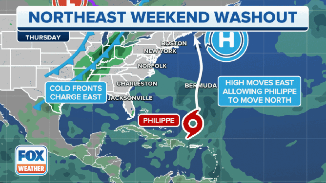
Philippe's next 48 hours will be a complex meteorological journey as the storm transforms from tropical in nature to drawing energy from more traditional sources. Meanwhile, as Philippe makes its approach to New England, it will interact with another storm system sweeping across the U.S. that’s expected to arrive in the Northeast about the same time, sending widespread rain through the region when the two systems interact.
"The front will bring its own moisture and wind energy with it," says FOX Weather Hurricane Specialist Bryan Norcross. "The net result will be rain from the front along the I-95 corridor in the Mid-Atlantic and Northeast today into tomorrow, with heavier rain and stronger wind in New England (Saturday) into Sunday as the combo coastal storm and front meet."
New York has already implemented their Flash Flood Emergency Plan as the flood risk increases for vulnerable areas. Cities like New York City, which flooded last week amid record rains, could be spared from serious water issues, but it’s not a guarantee.
Despite conditions that will be similar to a tropical storm, the NHC has opted not to issue Tropical Storm Watches or Warnings for the U.S. coastline, leaving warnings up to individual NWS offices.
WHAT TO EXPECT IN TROPICS AS HURRICANE SEASON ENTERS OCTOBER
Where is Post-Tropical Storm Philippe?

(FOX Weather)
Philippe is about 110 miles south of Bermuda and heavy rainfall is expected to continue through Friday for the island nation. On the forecast track, the system will continue passing Bermuda Friday and will reach the coast of Atlantic Canada or eastern New England Saturday night or Sunday.
Rainfall totals of 3-5 inches are expected through Friday in Bermuda, according to the NHC. They noted that these rainfall amounts may result in scattered flash flooding.
Where is Post-Tropical Storm Philippe going?

(FOX Weather)
Tropical Storm Philippe is moving north at about 15 mph, and the NHC said that general motion is expected to continue with an increase in its forward speed expected through the weekend.
Based on the forecast track, the weather will start to deteriorate in Atlantic Canada and coastal New England on Saturday with the center of the storm reaching the coast Sunday.

Watch: Hurricane Hunters get epic light show inside Tropical Storm Philippe
The Hurricane Hunters shared an amazing video of a lightning show inside Tropical Storm Philippe when the crew flew into the storm on Tuesday morning.
What are the expected impacts from Post-Tropical Storm Philippe in New England?
Those in Philippe's path should prepare for multiple weather-related threats, including flash flooding, power outages and dangerous surf along the coast.
New England can expect another weekend washout thanks to Tropical Storm Philippe and a storm system sweeping across the U.S.
(FOX Weather)
Because of Philippe's transformation into a post-tropical cyclone and its combination with the second approaching storm, impacts are expected well outside the forecast cone.

(FOX Weather)
As Philippe continues moving north, a storm system in the middle of the country will continue its journey to the east.
Heavy rain will be ongoing ahead of Philippe’s center by Friday, and the cold front charging across the U.S. will be getting stronger as it approaches the East Coast.

(FOX Weather)
As Philippe gets closer to New England and the Northeast by the weekend, the front will also be sweeping off the coast. This will lead to heavy rain across the Northeast and New England this weekend as the region feels the effects of both systems.
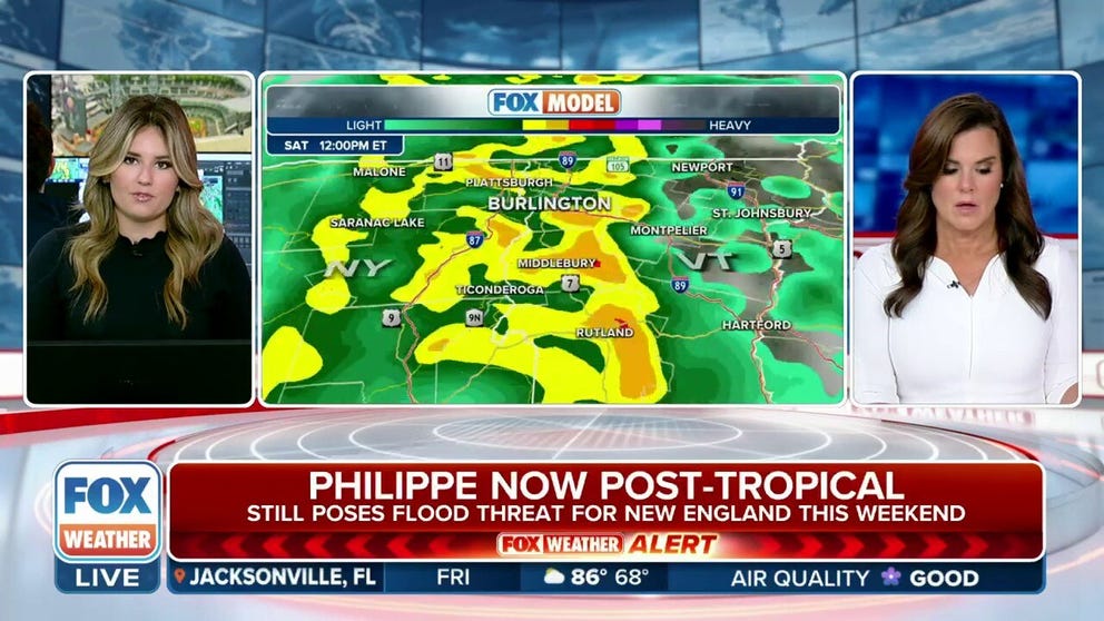
The flash flood risk has increased in the Northeast and New England as the ground is already heavily saturated from an extremely wet summer. The highest risk lies from eastern New York State to Maine.

(FOX Weather)
Most of the Northeast and northern New England can expect to see about 1-2 inches of rain through the weekend. However, portions of northern New York State, as well as Maine, could see 2-3 inches of rain, with some areas picking up 3-5 inches.
Meanwhile, wind gusts could reach 30-40 mph along coastal Maine and even stronger along Nova Scotia.
Due to the threat winds could down power lines, Nova Scotia Power is planning to activate its Emergency Operations Centre ahead of the storm. The utility performed similar preparations before Hurricane Lee threatened the region less than a month ago.
Possible tropical disturbance to emerge off Africa

(FOX Weather)
Things remain quiet elsewhere across the tropical Atlantic Ocean for now, but the NHC said there is a chance that a potential tropical disturbance expected to move off Africa could develop into a tropical system.
The NHC said the tropical wave will move off the west coast of Africa by Friday.
After that, some slow development is possible as it moves westward to west-northwest across the eastern Atlantic.
The NHC is giving the system a medium chance of developing over the next week as it remains harmlessly over the open Atlantic.