Three major cities along the I-95 corridor could get pounded with 20+ inches of snow from historic nor'easter
New York City, Boston, and Philadelphia are directly in the storm’s bull’s-eye, bracing for crippling snowfall, near-whiteout conditions, life-threatening travel and potentially widespread power outages.

New York City issues full travel ban ahead of major historic nor'easter threat
Beginning at 9 p.m. Sunday, New York City will be under a full travel ban. All public schools will also be closed tomorrow, including remote learning, as the major storm threatens to bring feet of snow and dangerous blizzard conditions.
A historic blizzard is charging along the I-95 corridor, threatening to dump more than 20 inches of snow on three major cities as the nor’easter is expected to bomb out off the East Coast.
LIVE UPDATES: NYC, BOSTON, PHILLY BRACE FOR HISTORIC BLIZZARD 'BOMB,' 2+ FEET OF SNOW EXPECTED
New York City, Boston, and Philadelphia are directly in the storm’s bull’s-eye, bracing for crippling snowfall, near-whiteout conditions, life-threatening travel and likely widespread power outages.
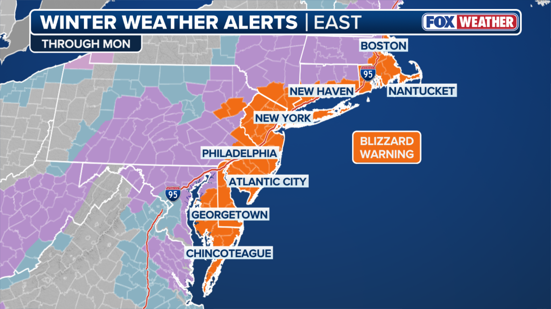
All three of these cities are not only under Blizzard Warnings, but the Winter Storm Severity Index has also placed them in the Extreme impact category.
(FOX Weather)
Both New York City and Philadelphia haven’t been under a Blizzard Warning in nearly a decade and Boston since Jan. 29, 2022, just highlighting the intensity of the storm's impacts.
(Getty Images)
The last time New York City saw snow to this measure was in January 2016, with a whopping 27.3 inches, and Philadelphia saw 22.4 inches.
On the other hand, Boston had just recovered from nearly 2 feet of snow in January when a massive cross-country storm tore through the area.
The FOX Forecast Center said that this could be one of the top 10 biggest storms for cities along the I-95 corridor and has the potential to shut down these major cities, with winds possibly reaching 70 mph in Boston and up to 50 mph and 60 mph in Philadelphia and New York, respectively.

Blizzard Warning for NYC as nearly 2 feet of snow could slam the city
FOX Weather Meteorologist Haley Meier is live from Times Square, where rain is going to quickly give way to snow this afternoon—and by tonight, full blizzard conditions are expected. New York is under a State of Emergency as this marks the first blizzard in nearly a decade barreling in, threatening up to 2 feet of snow.
As the sun sets, extremely heavy snow is expected, falling at 1–2 inches per hour, with some spots in Philadelphia and New York seeing 3–4 inches per hour.
(FOX Weather)
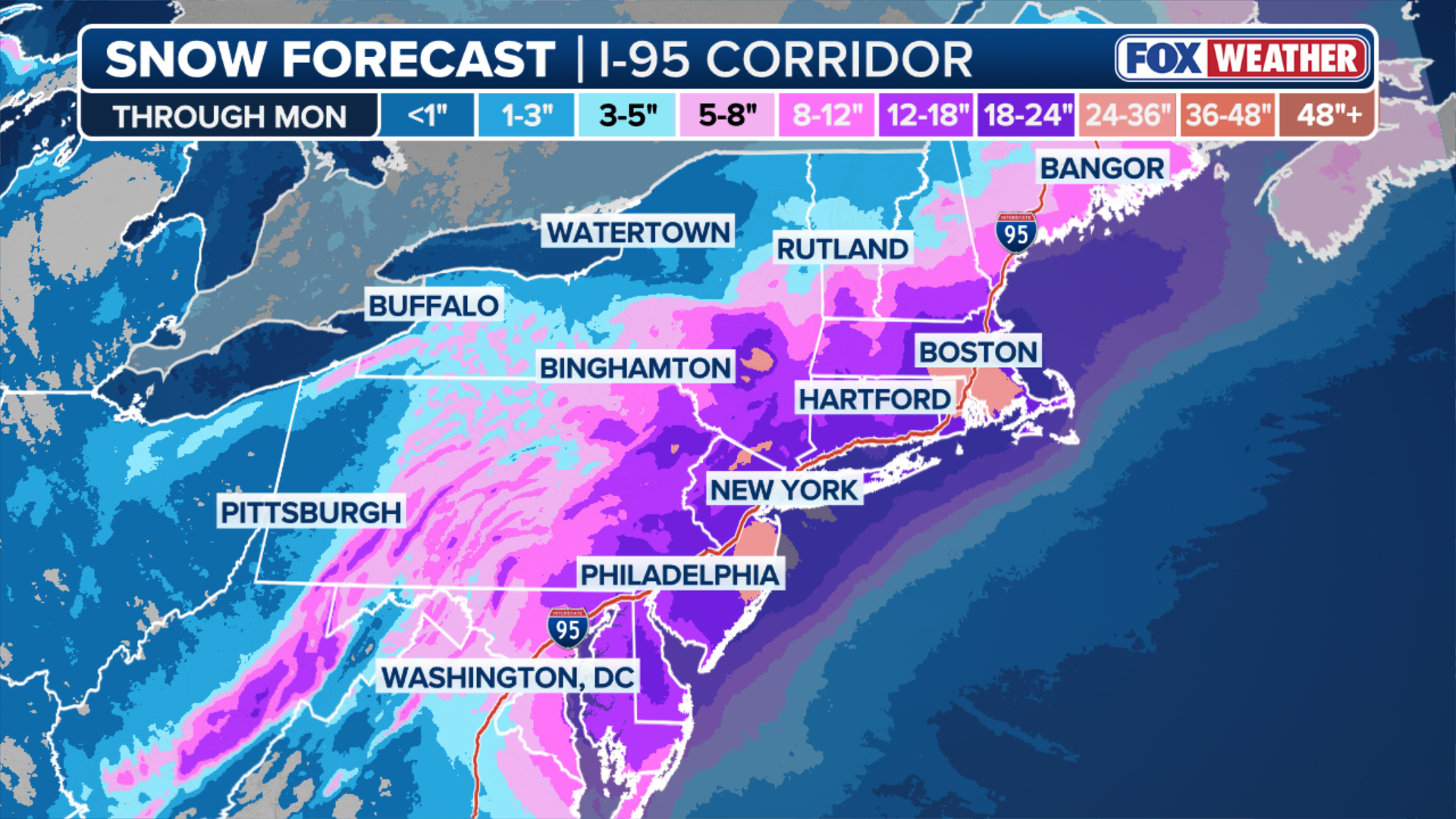
Boston could see 1–3 inches per hour by Monday morning, with total snowfall for these cities forecast between 18 and 24 inches.
New York City Mayor Zohran Mamdani joined FOX Weather this morning stating, "Staying home means you are staying safe," as the city is under a State of Emergency, with NYC Emergency Management issuing a Hazardous Travel Advisory for Sunday and Monday.
All New York City public schools are canceled for Monday, including remote learning. The city has also announced a travel ban starting Sunday night at 9 p.m.

New York City Mayor Zohran Mamdani joins FOX Weather ahead of historic nor'easter
The Big Apple is poised to get slammed by a historic blizzard Sunday, with the city expected to receive between 18-24 inches of snow. New York City Mayor Zohran Mamdani joined FOX Weather to discuss how the city is preparing for some historic winter weather:
New York Governor Kathy Hochul is warning people to take this storm seriously and Pennsylvania Governor Josh Shapiro is urging everyone to stay off the roads.

Historic nor'easter targets Boston with 2 feet of snow possible
A historic nor’easter is barreling across the I-95 corridor, bringing crippling winter conditions. FOX Weather Meteorologist Melanie Black is reporting live from Boston, where 2 feet of snow is expected to fall. Stay tuned to FOX Weather for the latest updates on this paralyzing storm.
Boston Mayor Michelle Wu has put a snow emergency and parking ban on the city starting at 2 p.m. on Sunday and once the snow emergency goes into effect, vehicles parked on major roads and main arteries will be towed, also urging everyone to stay off the roads, keep warm and stay safe.
![]() Image 1 of 3
Image 1 of 3BOSTON, MA - JANUARY 29: People protect themselves from blowing wind and snow during white-out conditions as a winter storm bears down on January 29, 2022 in Boston, Massachusetts. A powerful nor’easter brought blinding blizzard conditions with high winds, causing widespread power outages to much of the Mid-Atlantic and New England coast. The storm is predicted to drop over 2 feet of snow in some areas. (Photo by Scott Eisen/Getty Images) ( )
![FILE - People protect themselves from blowing wind and snow during white-out conditions as a winter storm bears down on January 29, 2022, in Boston, Massachusetts. A powerful nor’easter brought blinding blizzard conditions with high winds causing widespread power outages to much of the Mid-Atlantic and New England coast. The storm is predicted to drop over 2 feet of snow in some areas.]() Image 2 of 3
Image 2 of 3FILE - People protect themselves from blowing wind and snow during white-out conditions as a winter storm bears down on January 29, 2022, in Boston, Massachusetts. A powerful nor’easter brought blinding blizzard conditions with high winds, causing widespread power outages to much of the Mid-Atlantic and New England coast. The storm is predicted to drop over 2 feet of snow in some areas. (Scott Eisen)
![]() Image 3 of 3
Image 3 of 3A snowplow works to keep up with a winter storm as it bears down on January 29, 2022, in Boston, Massachusetts. A powerful nor’easter brought blinding blizzard conditions with high winds causing widespread power outages to much of the Mid-Atlantic and New England coast. The storm is predicted to drop over 2 feet of snow in some areas. (Scott Eisen)


All Boston public schools have been canceled for Monday ahead of the storm threat.
The storm is expected to peak overnight into Monday and, when it's all said and done, multiple cities could be looking at a top 10 or top 5 snowstorm.