Live updates: Historic blizzard shuts down major I-95 corridor cities as paralyzing 'bomb' begins
Live updates: Historic blizzard shuts down major I-95 corridor cities as paralyzing 'bomb' begins
Download the AppLIVE Blizzard '26 coverage continues
View postCoverage for this event has ended.
FOX Weather is your Winter Storm HQ, providing around-the-clock live coverage to help keep your family safe.
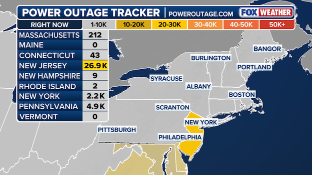
More than 250,000 customers are without power right now as blizzard conditions blast the Northeast and Mid-Atlantic.
New Jersey is seeing the greatest number of outages with more than 100,000 customers without electricity.
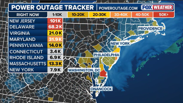
Power outage tracker
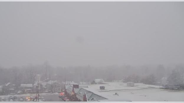
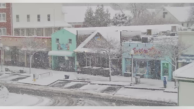
The snow is piling up through the overnight hours on New York's Long Island.
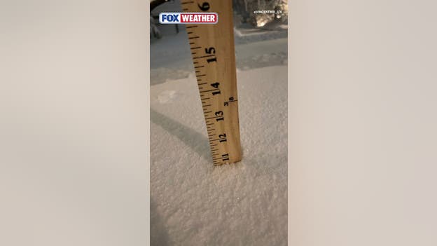
Credit: @VINCENTWX_1/X
Although heavy snow did not begin until the evening, daily snowfall records were shattered across the New York City tri-state area Sunday.
Intense snow is expected across the region through mid-morning Monday.
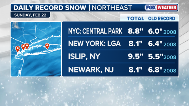
Daily snowfall records
While millions across the Northeast hunker down for the historic nor'easter slamming the region, the Hurricane Hunters are flying directly into the heart of the storm.
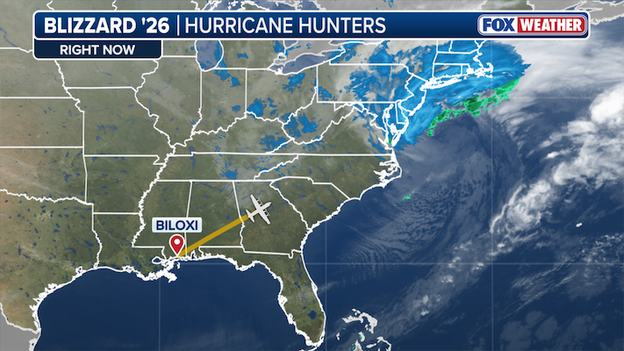
Hurricane Hunters depart for bombing nor'easter hammering the East Coast.
The 53rd Weather Reconnaissance Squadron 71 Hurricane Hunters have departed from Keesler Air Force Base in Biloxi, Mississippi to survey and collect data from the monster storm bombing off the East Coast.
These daring missions collect critical data that give meteorologists the insight they need to accurately forecast the strong nor'easter.
While they are known for hurricanes, the squadron also flies winter storm missions off both U.S. coasts. These flights provide real-time atmospheric data that satellites and ground stations simply cannot capture.
This information is fed directly into weather models to help forecasters predict exactly where the heaviest snow bands and strongest winds will hit.
FOX Weather Storm Specialist Mike Seidel reports live from Montauk, New York, as heavy snow and high winds continue to slam the Northeast.
The powerful nor'easter currently slamming the Northeast has officially met the meteorological criteria to be classified as a bomb cyclone.
With a central pressure of 988mb the storm has officially “Bombed out."
This rapid intensification, known as bombogenesis, occurs when a storm's central pressure plummets by at least 24 millibars within a 24-hour period.
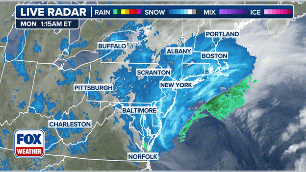
FOX Forecast Center Live Radar
While the exact required pressure drop can vary slightly based on latitude, the process remains a clear signal of an exceptionally violent storm. The standard is a 24-millibar drop in 24 hours.
For cities like New York, the required drop to be considered a "bomb" is approximately 17.8 millibars over a single day.
And the FOX Forecast Center confirms this storm is deepening rapidly offshore, and will trigger hurricane-force wind gusts and massive instability within heavy snow bands overnight.
A nor'easter becoming a bomb cyclone is more than just a dramatic headline—it signals a dangerous escalation in storm impacts.
As the pressure bottomed out today, it caused winds to accelerate and snowfall rates to intensify to a staggering 2 to 3 inches per hour in some areas. This rapid strengthening is precisely why Blizzard Warnings in effect for over 40 million people.
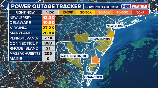
Power outages across the Northeast continue to climb as the paralyzing impacts of the monster nor'easter overwhelm utilities from Virginia through New Jersey.
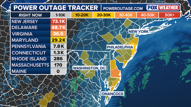
Power Outage Map
As of early Monday morning, the number of customers in the dark has skyrocketed, officially crossing the 200,000 mark across the region, according to poweroutage.com.
New Jersey: The hardest-hit state, now reporting a staggering 73.1K outages, nearly doubling in just a few hours.
Delaware: Still reeling with 48.7K customers without power.
Virginia: Seeing a sharp rise to 36.6K outages as the wind continues to howl.
Maryland: Currently sitting at 29.2K outages.
Pennsylvania: Climbing to 7.8K outages.
The New Jersey Turnpike Authority is battling a nightmare on the state's most critical travel arteries as the bombing nor'easter brings travel to a grinding halt.
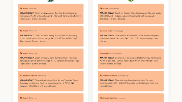
New Jersey Turnpike Authority's Major Delays
The New Jersey Turnpike Authority is reporting several major delays on both the New Jersey Turnpike and the Garden State Parkway as the monster nor'easter spawns dangerous travel conditions.
Several crashes, downed trees and disabled vehicles have been reported throughout the night as crews rush to combat major delays on the two essential highways.
New Bedford is disappearing under a thick white blanket as a monster nor'easter takes hold in southeastern Massachusetts.
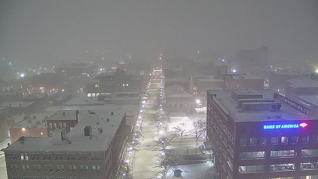
WxVision New Bedford Camera
This monster winter storm has New Bedford directly in its crosshairs, packing high winds and dumping heavy snow across the region.
In Westchester County, a car slid off a road in Mamaroneck, New York, as heavy snow and high winds continue to pummel the region.
The dangerous reality of this monster nor'easter is on full display here as increasing snow rates and high winds have locked in treacherous travel conditions.
New York registered a major milestone as heavy snow continues to fall.
As this high-impact storm hammers the Northeast, we have officially recorded the first foot of snow of the historic nor'easter.
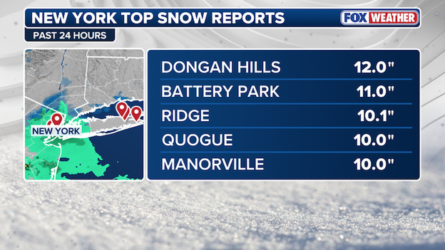
New York Snow Totals
Dongan Hills (Staten Island): 12.0 inches.
Battery Park (Manhattan): 11.0 inches.
Ridge (Suffolk): 10.1 inches.
Quogue: 10.0 inches.
Manorville: 10.0 inches.
FOX Weather's live radar as of 11:30 p.m. showcases the sheer size of the monster nor'easter that is locked in over much of the Mid-Atlantic.
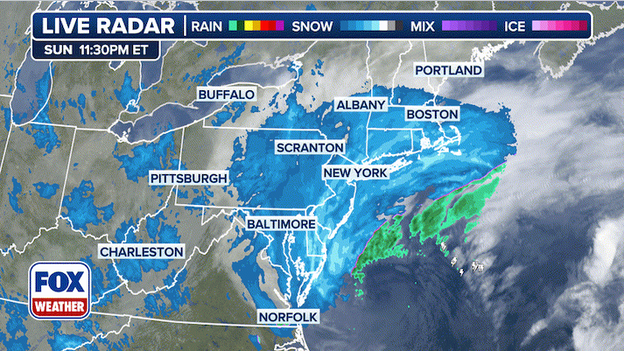
FOX Weather Live Radar
Casting a massive swath stretching from Delaware through Boston, this historic nor'easter will continue to slam areas along the East Coast with dangerous winds and heavy snow through Monday.
Power outages have skyrocketed across the Northeast and Mid-Atlantic region as over 150,000 customers are without power, according to date from poweroutage.com.
Power Outage Tracker powered by poweroutage.com
The blockbuster nor'easter continues to slam the East Coast with hurricane-force gusts and heavy, wet snow, the power outage tracker is lighting up across the Mid-Atlantic.
Right now, tens of thousands are already in the dark, and with the storm still intensifying, these numbers are expected to continue to climb as the night wears on.
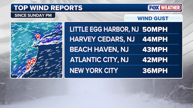
While the snow totals are climbing into the double digits, it's the wind that is turning this nor'easter into a true monster.
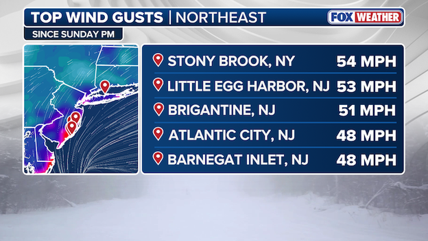
Top Wind Gusts in the Northeast
Stony Brook, NY tops the list with a massive 54 mph gust as the storm intensifies over Long Island.
The FOX Forecast Center's top wind gusts detail where the dangerous winds are fueling blizzard conditions across the Northeast, creating life-threatening whiteouts that have state officials urging people to stay off the roads throughout the region.

A powerful, bombing nor'easter is currently slamming the Northeast with life-threatening blizzard conditions.
FOX Weather Storm Specialist Mike Seidel is in Montauk, New York tracking the blizzard as high winds and heavy snow create treacherous conditions that have millions across the region under threat.
The monster nor’easter slamming the East Coast has officially crossed a major milestone.
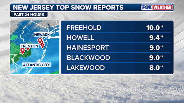
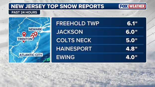
New Jersey top snow reports
As the storm pummels the I-95 corridor with blinding snow and treacherous winds, we finally have our first double-digit snow report of this blockbuster event.
The first 10" snow report of the nor'easter has been recorded in Freehold, New Jersey.
According to data from poweroutage.com, over 110,000 power outages have been reported across the Mid-Atlantic and Northeast as the crippling impact of the historic nor'easter slams areas along the East Coast.
With Blizzard Warnings are widespread across the Mid-Atlantic and Northeast as the monster storm continues to pummel the region with heavy, wet snow and high wind gusts.
Power Outage Tracker
In New Jersey, more than 28,000 customers are in the dark. The hardest-hit areas are coastal Monmouth and Ocean counties, where blizzard conditions and dangerous wind gusts are already taking a toll.
Over 29,000 are without power in Delaware, and outages in Virginia surpass 24,000.
In Maryland over 20,000 customers are without power, as outages are rapidly rising across the Northeast and Mid-Atlantic as the impacts of the monster nor'easter begin to mount.
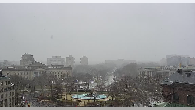
The Birthplace of Liberty is currently being swallowed by the monster, high-impact nor'easter. Snow has started piled up at Independence Hall in Philadelphia as the city braces for the historic storm.
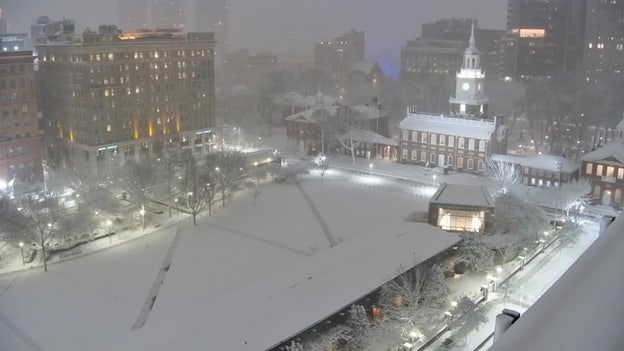
WxVision live shot of Independence Hall in Philadelphia
According to the FOX Forecast Center, Philadelphia is forecast to see an additional of 18-24" through Monday, as the initial round of snowfall settles down in the City of Brotherly love.
Philadelphia Mayor Cherelle Parker has already declared a Disaster Emergency, with over 800 pieces of equipment and 1,000 personnel working around the clock to combat the crippling effects of the monster storm.
FOX Weather Field Correspondent Katie Byrne is live from Long Branch, New Jersey, as the ferocious impacts of the nor'easter grasp the popular Jersey Shore town.
A nor'easter "bomb cyclone" is now blasting of Americans in the Northeast with life-threatening blizzard conditions.
- Blizzard Warnings in effect: Blizzard Warnings are in effect for major hubs including New York City, Philadelphia, and Boston, affecting more than 40 million people. This is the first blizzard warning for NYC since 2017.
- Snow amounts: Widespread accumulations of 12 to 24 inches are expected across the I-95 corridor. The heaviest snow is forecast for Sunday night into Monday morning, with rates occasionally reaching 2 to 3 inches per hour.
- Dangerous winds & visibility: Wind gusts of 50 to 70 mph will create life-threatening whiteout conditions and near-zero visibility.
- States of Emergency: Governors across 7 states have declared States of Emergency. State leaders are telling everyone to stay at home until conditions improve.
- Major transit disruptions: NYC and other communities have announced mandatory travel bans starting Sunday evening. Over 9,000 flights have already been canceled through Tuesday. Amtrak has modified its Northeast Corridor schedule, and NJ Transit has announced service suspensions starting this evening.
- Power outage risk: The combination of heavy, wet snow and high wind load is likely to cause numerous to widespread power outages and tree damage throughout the region.
- Coastal flooding: A storm surge of 2 to 4 feet could cause moderate coastal flooding and beach erosion from Delaware Bay to Cape Cod during high tide cycles.
- Classes canceled: New York City and Boston Public Schools have called off all classes for Monday. Numerous other school districts are closing down and telling students to stay home due to the storm.
Delaware Governor Matthew Meyer has issued a Level 3 Driving Ban for Kent and Sussex Counties effective at 10:00 p.m. until further notice as the ferocious nor'easter continues to lash the Northeastern coast.
Under whiteout conditions, the declaration essentially bans travel in the two coastal counties as high wind gusts and heavy snow rates have set the stage for extremely dangerous and rugged driving conditions.
The declaration of the driving ban comes after Gov. Meyer issued a Level 2 driving restriction.
Under a Level 2 notice, no person may operate a motor vehicle on Delaware roadways, except for essential personnel including first responders, operators of snow removal equipment and other drivers deemed essential by the state.
Level 2 Driving Restriction is now in place in New Castle County for the time being.
The state-mandated driving restrictions aim to minimizing nonessential travel during severe weather events like the historic nor'easter threatening dangerous blizzard conditions in the two coastal Delaware counties.
While the Level 2 restriction is currently limited to Kent and Sussex counties, a Level 1 Driving Warning remains in effect for New Castle County, where motorists are encouraged to exercise extreme caution.
New York City is now officially under a total travel ban as the historic blizzard enters its most dangerous phase.
As of 9:00 p.m., all city streets, highways, and bridges are closed to non-essential vehicular traffic, a restriction that remains in effect until noon on Monday.
Mayor Zohran Mamdani and Governor Kathy Hochul have warned that the ban will be strictly enforced to allow emergency responders and plow crews to manage the expected 1 to 2 inches of snow falling per hour.
I’m urging every New Yorker to please stay home. Check in on your neighbors, especially seniors and those who may need extra support.
State police are pre-staged to ensure all non-exempt vehicles—including cars, trucks, e-bikes, and scooters—stay off the roads.
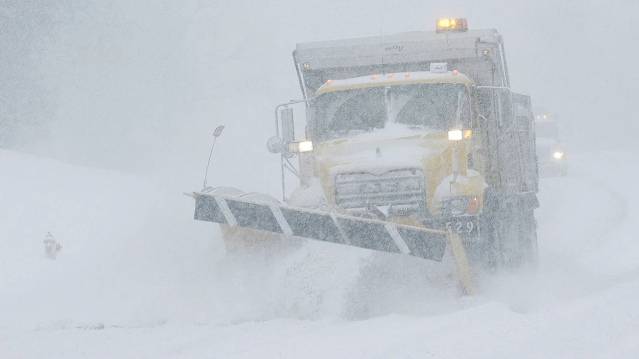
As the nor'easter slams into high gear, New York State Department of Transportation (NYSDOT) crews are hard at work on Long Island.
While residents are urged to stay off the roads, plow operators are combating the emerging impacts of the historic nor'easter as high winds and heavy snow kick into gear, producing extremely dangerous travel conditions tonight and into tomorrow.
On Long Island, as of 8 p.m., Deer Park has already measured 4.1 inches of snow, according to the FOX Forecast Center.
Thankfully New York City's well-attended Broadway shows have been suspended tonight, because phones in the audience would have caused quite the interruption at 8 p.m.
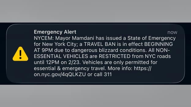
NYCEM Emergency Alert sent to a New Yorker's phone
A buzzing alert from New York City Emergency Management reminded New Yorkers of the travel ban that takes effect beginning at 9 p.m. EST.
With NYC under a State of Emergency, the Big Apple's first travel ban in over a decade restricts all non-essential vehicles from NYC roads until noon tomorrow as the crippling impact of the intense nor'easter takes hold across the Northeast.
The first reports of more than 6 inches of snow has been reported in Freehold, New Jersey.
New Jersey Top Snow Reports
According to the FOX Forecast Center, these heavy accumulations in New Jersey are a direct result of the rapid strengthening of the nor'easter. Unlike the earlier snowfall seen in the Virginias, which was largely elevation-enhanced by the Appalachian terrain.
The impact of the powerful nor'easter is beginning to take hold through the Northeast, as thousands of residents are finding themselves in the dark as we approach the evening hours.
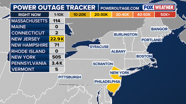
Power Outage Tracker using data from poweroutage.com
The Garden State is currently the epicenter of utility disruptions in the Northeast. According to data from poweroutage.com, New Jersey is reporting over 22,900 customers without power.
Governor Wes Moore has declared a State of Emergency in Maryland, becoming the seventh state to do so as the impacts of the historic nor'easter take hold in the Northeast.
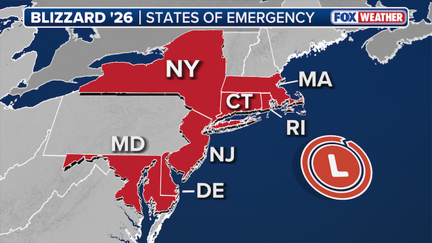
Maryland becomes the 7th state to declare a State of Emergency
Governors in Delaware, New Jersey, New York, Connecticut, Rhode Island and Massachusetts have already declared States of Emergency.
“The safety of Marylanders comes first and this storm has the potential to produce life-threatening conditions across large parts of the state,” Gov. Moore said in a press release. “Stay off the roads, check on your neighbors, and listen to local authorities. Please be vigilant and take this storm seriously to protect yourself and your loved ones.”
In addition to increasing Maryland State Police staffing, the governor has activated approximately 45 Maryland Army National Guard soldiers with 18 high-clearance vehicles on Maryland's Eastern Shore to ensure rapid response capabilities for communities that may require assistance.
Snow totals are officially beginning to climb as the nor'easter moves into the New York City metro area.
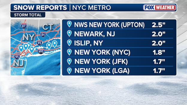
New York City snow accumulation reports as of around 7 p.m. ET Sunday.
- NWS New York office: 2.5 inches
- Newark (EWR) Airport: 2.0 inches
- Islip (ISP): 2.0 inches
- Central Park: 1.8 inches
- LaGuardia (LGA) Airport: 1.7 inches
- JFK Airport: 1.7 inches
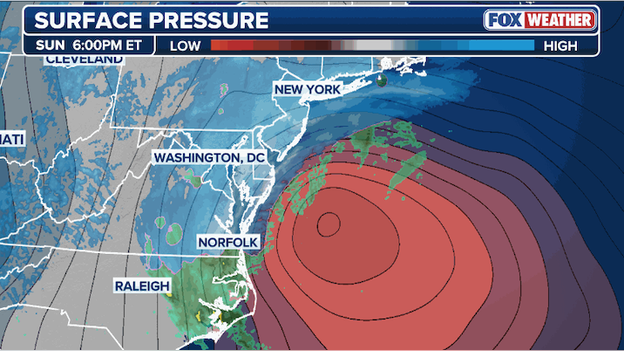
Surface analysis shows the nor'easter is now 'bombing out' just off the U.S. East Coast.
New analysis of the coastal nor'easter shows a dramatic drop in central pressure, confirming that the storm is undergoing rapid bombogenesis.
As of the most recent reading, the pressure has fallen to 994mb, down from 998mb just three hours ago.
This 4mb drop in only three hours is a significant indicator of the storm's power; at this current rate, the system would drop 32mb over a 24-hour period, well exceeding the standard 24mb in 24 hours required to officially be classified as a bomb cyclone.
To accommodate winter weather operations and ensure safety as the blizzard intensifies, the MTA has suspended service on the C line.
Most other subway lines have been shifted to run local service as crews now work around the clock to clear snow from platforms and station entrances.
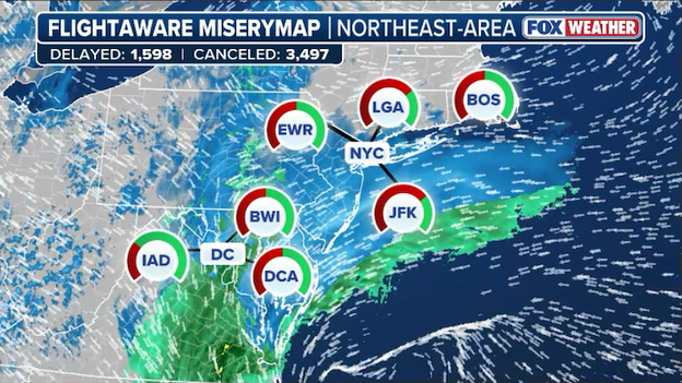
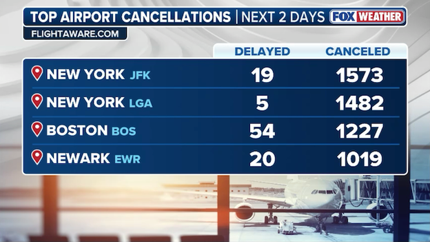
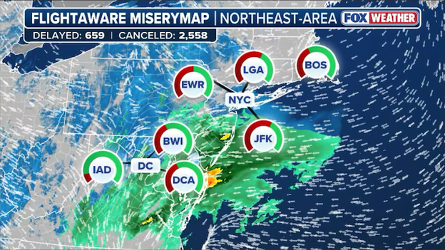
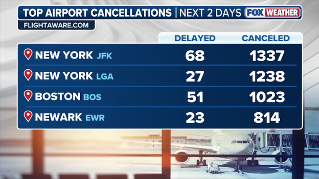
FlightAware MiseryMap showing flight disruptions throughout the Northeast.
Air travel has ground to a virtual standstill in the Northeast as the historic blizzard begins its relentless assault.
FlightAware data now confirms that more than 15,000 U.S. flights have been disrupted through Tuesday, a staggering number that reflects the sheer scale of the blizzard's impact on major aviation hubs.
The grounding is near-total at critical hubs including JFK, LaGuardia, Newark, and Boston Logan.
At LaGuardia alone, over 90% of Monday flights were canceled preemptively as airlines scrambled to keep aircraft and crews from being stranded.
While more than 9,240 flights have been completely canceled, another nearly 6,000 have faced significant delays, with these numbers expected to climb further as the storm reaches its peak tonight.
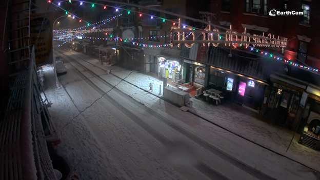
EarthCam showing the snow-covered Mulberry Street in Lower Manhattan.
Road conditions across New York City are deteriorating at a dangerous pace as heavy snow bands finally begin to coat even the most heavily trafficked corridors.
EarthCam's view from Mulberry Street shows the iconic neighborhood quickly disappearing under a white blanket, with visibility dropping and surfaces becoming treacherous just as the citywide travel ban takes effect.
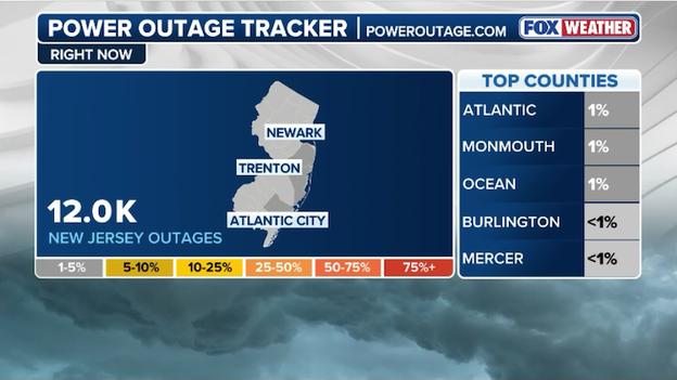
Latest power outage tracker showing more than 12,000 customers without power in New Jersey.
Power outages are beginning to surge along the Jersey Shore as the bomb cyclone brings its most violent conditions to the coastline.
According to PowerOutage.com , Ocean County is currently the hardest-hit area in New Jersey, with 3,765 customers already in the dark. Monmouth County is following closely behind with 3,753 outages, while Atlantic County reports over 2,500 homes and businesses without power.
Rhode Island Governor Dan McKee has declared a State of Emergency and issued a mandatory statewide travel ban as the region prepares for a high-impact blizzard.
The FOX Forecast Center warns that the state could be buried under 18 to 24 inches of heavy, wet snow, with wind gusts reaching up to 60 mph.
As of 5 p.m. ET, all commercial vehicle travel is prohibited on all roads statewide. At 7:00 p.m., a total restriction on all motor vehicle travel goes into effect for all roads statewide until further notice.
We're asking Rhode Islanders to take this storm seriously and stay home.
Rhode Island State Police have deployed extra troopers to monitor highways, and the Governor has authorized the activation of the Rhode Island National Guard to support the state's emergency response.
All non-essential state government offices will be closed on Monday. The University of Rhode Island is closing all offices and canceling all classes for Monday. Major school districts, including Newport Public Schools, have also announced closures for Monday.
"We're asking Rhode Islanders to take this storm seriously and stay home," Governor McKee said during the announcement, emphasizing that the most dangerous whiteout conditions are expected between 1:00 AM and noon on Monday.
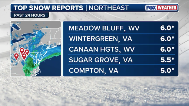
Latest top snow reports from around the Northeast as of 6 p.m. ET Sunday.
Meadow Bluff, West Virginia, has just reported a significant 6.0 inches of snow as the storm's initial wave continues to pile up across the Mid-Atlantic.
This total matches the highest reported accumulation so far today, putting Meadow Bluff on par with Wintergreen, Virginia, as the Northeast prepares for even heavier bands tonight.
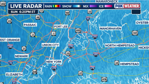
Radar image showing heavy snow now hammering the New York City metro area.
Snow intensity is ramping up significantly across the Tri-State area as the historic blizzard enters its most dangerous phase.
The National Weather Service in Upton indicates that Newark (EWR), JFK, and Islip (ISP) all recorded snow rates of 1 inch per hour during the window between 5:00 p.m. and 6:00 p.m. ET.
Due to the historic blizzard and significant snow accumulations expected across the state, NJ Transit is implementing a series of major service suspensions beginning this evening.
Transit officials are prioritizing the safety of both passengers and employees as blizzard conditions intensify.
- Bus, Light Rail, and Access Link: All services are now suspended.
- Rail Service: Service will be suspended systemwide by 9 p.m. tonight.
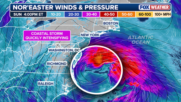
Wind speeds are steadily increasing this evening as the storm strengthens off the Northeast coast.
Winds are accelerating across the Northeast as the coastal low-pressure system begins its explosive "bomb out" phase.
The central pressure is forecast to plummet to near 970 MB by dawn, a rapid deepening that acts like an atmospheric vacuum, pulling in ferocious wind gusts that could soon reach hurricane force.
Wind gusts could reach 75 mph near Boston and out on the Cape as the storm blasts the coastline.
The rare and dramatic phenomenon of thundersnow is now a distinct possibility as the historic blizzard undergoes explosive intensification off the coast.
Thundersnow typically occurs in the most intense parts of a winter storm, where powerful rising air or extreme lift creates the same atmospheric instability seen in summer thunderstorms—just with snow instead of rain.
The FOX Forecast Center has identified several high-risk zones for thundersnow during the overnight and early Monday morning hours:
- The "jackpot" snow bands: Thundersnow will likely occur where the radar shows the highest intensities, specifically in areas where snow rates reach a staggering 2 to 4 inches per hour.
- New York City and Long Island: Forecasters are closely monitoring the potential for thundersnow overnight in the Tri-State area as the core of the bomb cyclone passes just offshore.
- Coastal New England: The National Weather Service in Boston has noted "exceptionally strong lift" early Monday morning, particularly for Rhode Island and Southeastern Massachusetts, which could trigger lightning and thunder within heavy snow bands.
- The Jersey Shore: Coastal areas from Atlantic City to Sandy Hook are in the direct path of the most violent frontogenetic forcing, clashing air masses that will create enough atmospheric energy, making them prime candidates for thundersnow.
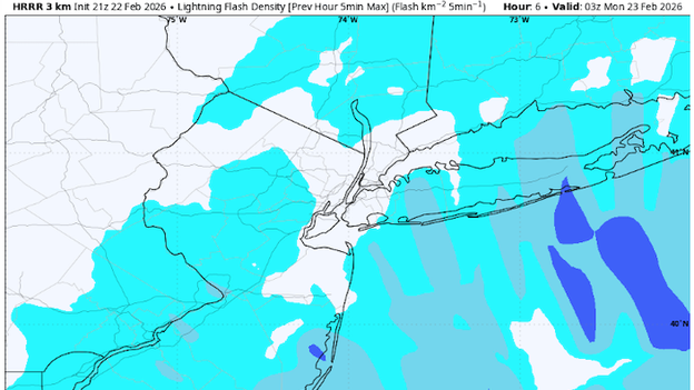
High Resolution Rapid Refresh model indicating where lightning may strike tonight near New York City. (Source: WeatherBELL)
Because heavy snow effectively muffles sound, you may not hear a distant roll of thunder; instead, it often sounds like a sudden, sharp thunderclap that can only be heard within about three to five miles of the lightning strike.
If you see a flash of light followed by a dull rumble, it is a sign that you are in the heart of the storm's most extreme snow, where rates are at their highest and visibility is at its lowest.
Air travel has ground to a virtual standstill across the country as the historic "bomb cyclone" begins its relentless assault on the Northeast.
FlightAware now reports confirms that more than 14,000 U.S. flights have been disrupted through Tuesday, a staggering number that reflects the sheer scale of the blizzard's impact on the nation's aviation hubs.
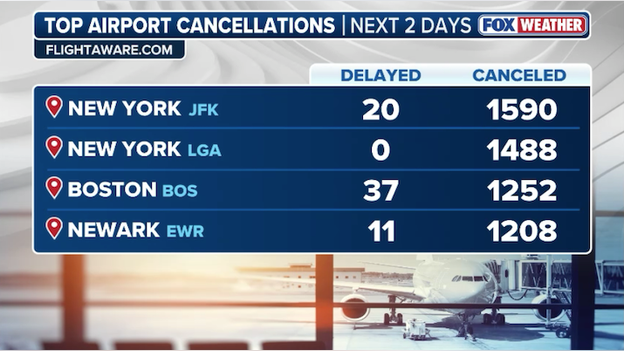
Thousands of flights across the U.S. have been canceled as the blizzard 'bombs' the Northeast. (FlightAware)
The scale of the grounding is staggering, with over 8,858 U.S. flights canceled so far and thousands more delayed.
Major hubs including JFK, LaGuardia, Newark, and Boston Logan are seeing near-total shutdowns.
At LaGuardia alone, more than 90% of Monday flights were canceled preemptively as airlines scrambled to keep aircraft and crews from being stranded in the storm's path.
With the once-in-a-generation blizzard now bombing millions along the East Coast, we know everyone is itching to grab a yardstick and see how their town stacks up against the forecast.
However, as 70 mph winds whip through the I-95 corridor, getting a true reading is about more than just poking a ruler into the nearest drift.
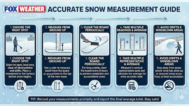
Use this handy guide to accurately measure snow during and after the blizzard.
To help you report the most accurate ground truth to the National Weather Service (NWS) and FOX Weather, follow this official guide to snow measurement.
- Choose the right spot: Location is everything. Avoid measuring in the grass, as individual blades can prop up the snow and artificially inflate your totals by an inch or more. You also want to stay away from buildings, trees, or fences, which can cause shadowing or unnatural accumulation. The gold standard is a snowboard—a flat, white-painted wooden board (ideally 16" x 16") placed in an open area away from your house. If you don't have one, a level picnic table or a deck far from the siding will work in a pinch.
- Measure from the ground up: Use a ruler or yardstick and push it straight down until it hits your measuring surface. Always record your measurements to the nearest tenth of an inch (e.g., 8.3") rather than rounding to the nearest whole number.
- The 6-hour rule: clear the board periodically: For a long-duration event like this blizzard, the NWS recommends measuring and clearing your board every 6 hours. This prevents the snow from compacting under its own weight, which can happen quickly with heavy, wet accumulation. Pro Tip: Never clear your board more than four times in a 24-hour period, as doing so too often will grossly inflate your final storm total.
- Take an average: In high-wind events, snow is never distributed evenly. To get an accurate reading, take multiple measurements in different representative spots around your yard—avoiding the massive drifts—and average them together. If you have three readings of 10", 12", and 11", your average report is 11 inches.
- Avoid drifts and windblown areas: During a blizzard, undercatch and drifting are your biggest enemies. If your snowboard is scoured bare by the wind or buried under a four-foot drift, move to a more sheltered, level area. Official snow depth (the total amount currently on the ground) is different from snowfall (the new accumulation) and should be reported to the nearest whole inch.
Camera showing snow starting to stick in Baltimore, Maryland as the nor'easter kicks into high gear.
Snow is officially beginning to stack up across the Baltimore region as the historic nor'easter intensifies off the East Coast.
After a day of chilly rain, temperatures have begun to plummet toward the freezing mark, allowing the precipitation to change over to a heavy, wet snow that is now accumulating on all surfaces.
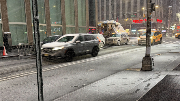
Photo from FOX Forecast Center meteorologist Mathieu Blue showing snow sticking along 6th Avenue in New York City.
Heavy snow bands are rolling into Midtown Manhattan, where plunging temperatures are finally allowing the snow to stick to the streets and sidewalks of Times Square.
This rapid accumulation marks the beginning of the storm's peak intensity, with the FOX Forecast Center warning that visibility will vanish as snow rates climb toward 2 inches per hour tonight.
The latest mesoscale analysis from the FOX Forecast Center shows the nor'easter reaching a dangerous new phase as it moves up the coast.
A large corridor stretching from Washington through Philadelphia and into New Jersey is now experiencing consistent snow rates of 1 to 2 inches per hour.
Meteorologists are highlighting a specific "red zone" along the Delmarva Peninsula and the Jersey Shore, including Chincoteague, Lewes, and Atlantic City, as the area with the best chance for full blizzard conditions over the next few hours.
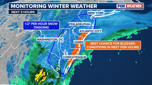
Radar analysis showing where blizzard conditions are likely in the next few hours.
In these locations, powerful wind gusts are combining with heavy snow to reduce visibility to near zero.
This intense activity is expected to continue tracking north toward the New York City metro area as the evening progresses.
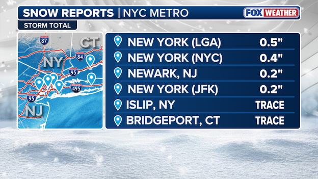
New York City snow accumulation reports as of 4 p.m. ET Sunday.
Snow totals are officially beginning to climb as the nor'easter moves into the New York City metro area.
The FOX Forecast Center has received the first batch of official 4:00 p.m. ET snow reports, marking the transition from a cold rain to accumulating snow across the region.
While these initial totals are modest, they represent just the first phase of what is expected to be a historic event. Meteorologists expect these numbers to surge over the next few hours as temperatures continue to fall and the storm's most intense snow bands arrive. The next official update for these primary recording sites is scheduled for just after 7 p.m. ET.
Official snow accumulation as of 4:00 p.m.:
- LaGuardia (LGA) Airport: 0.5 inches
- Central Park: 0.4 inches
- Newark (EWR) Airport: 0.2 inches
- JFK Airport: 0.2 inches
- Islip (ISP): Trace
- Bridgeport (BDR): Trace
Intense snow bands are now pushing into the New York City metro area and Long Island, signaling a dangerous phase of this historic blizzard.
As temperatures fall below 32°F, the snow is beginning to stick to all surfaces, including roads that were previously just wet.
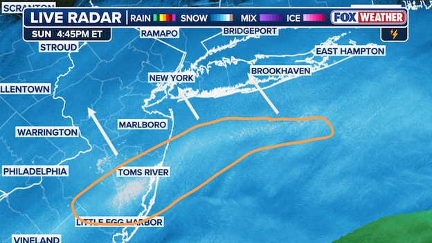
Radar shows moderate to heavy snow bands approaching New York City and Long Island.
Snow rates will increase to .50-1.0 inch per hour through 8 p.m. ET, but these numbers are expected to climb significantly after sunset.
Forecasters in the FOX Forecast Center warn that the combination of plunging temperatures and heavy snow will make travel life-threatening within the next hour or two.
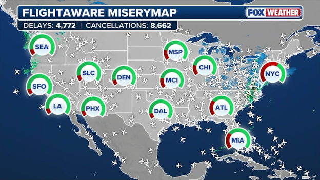
FlightAware MiseryMap showing nationwide disruptions due to the blizzard.
The massive bomb cyclone slamming the Northeast has effectively paralyzed air travel across the United States.
As of 4:15 p.m. ET today, FlightAware reports more than 13,400 U.S. flights have already been disrupted through Tuesday.
However, total disruptions are expected to continue to surge as the storm begins its assault.
The scale of the grounding is staggering, with over 8,662 U.S. flights canceled so far and thousands more delayed.
Major hubs including JFK, LaGuardia, Newark, and Boston Logan are seeing near-total shutdowns, with JFK reporting 82% of Monday flights canceled and LaGuardia canceling 91%.
Even international travel has been hit, with carriers grounding services to New York and Newark, while disruptions in the Northeast corridor are causing ripple effects as far away as Costa Rica.
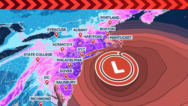
Analysis from FOX Weather shows the blizzard taking shape as low pressure intensifies off the East Coast.
The "generational" tag on this blizzard is rapidly moving from hyperbole to reality as the storm begins explosive bombogenesis off the East Coast, with more than 40 million people now under Blizzard Warnings.
The FOX Forecast Center warns that while the afternoon began with a deceptive calm, conditions are set to deteriorate violently tonight as snow rates jump to a staggering 2 to 3 inches per hour.
Combined with hurricane-force wind gusts of up to 75 mph, this "bomb cyclone" will create a total whiteout along the I-95 corridor that has already triggered mandatory travel bans in New York City, Connecticut, and Philadelphia.
With up to two feet of snow "locked in" for major hubs like Boston and NYC, the sheer intensity of the overnight window—especially between 2:00 a.m. and 6:00 a.m.—is expected to paralyze the region and potentially lead to widespread, long-duration power outages.
The FOX Forecast Center has finalized its snow forecast for the Interstate 95 corridor, confirming that a historic and life-threatening event is now in its early stages.
As the nor'easter undergoes rapid intensification off the coast, a massive swath of the Northeast is "locked in" for debilitating snow totals through Monday.
The latest data shows a significant jackpot zone where totals will likely exceed two feet:
- 2-3 feet: Boston, Hartford, and much of Rhode Island and Eastern Massachusetts, and the Jersey Shore are expected to see the most intense snow.
- 18–24 inches: A wide corridor including New York City and Philadelphia is expected to see up to two feet of accumulation.
- 12–18 inches: Significant totals will extend farther south toward Maryland and north toward Portland and Bangor, Maine.
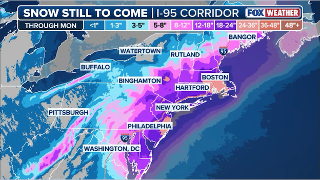
Final snow forecast from FOX Weather as the historic blizzard bears down on the Northeast.
The FOX Forecast Center says some spots could even see more than 3 feet of snow if a mesoscale snow band develops and parks itself over localized areas.
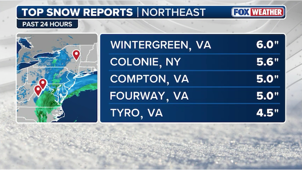
Latest top snow reports from the historic blizzard ramping up across the East.
The latest reports from the FOX Forecast Center show that snow is already piling up across the Mid-Atlantic and parts of New York as the historic blizzard intensifies.
Wintergreen, Virginia, currently holds the top spot with 6.0 inches of accumulation recorded over the past 24 hours.
Close behind is Colonie, New York, which has already seen 5.6 inches as the storm's northern edge begins to take hold.
Other notable totals include Compton and Fourway, Virginia, both reporting 5.0 inches, while Tyro, Virginia, has recorded 4.5 inches.
These totals are expected to be eclipsed rapidly overnight as the storm "bombs out" and moves into the I-95 corridor, where snow rates of 1 to 3 inches per hour are forecast.
The FOX Forecast Center has released a critical power outage forecast as the historic bomb cyclone begins its rapid intensification off the East Coast.
With near-hurricane-force wind gusts and heavy, wet snow expected to lash the region through Monday, residents in the I-95 corridor should prepare for significant and potentially long-lasting service disruptions.
According to the latest data from FOX Weather, the threat levels are tiered as follows:
- Widespread outages: The highest risk areas include Long Island, Southeastern Massachusetts (including Cape Cod and the Islands), and the Jersey Shore. These coastal zones will face the most violent winds and the heaviest snow accumulation.
- Likely outages: Power failures are highly probable for major metropolitan areas including New York City, Boston, Hartford, and Philadelphia.
- Possible outages: Service interruptions may extend further inland to cities like Washington, D.C., Harrisburg, Scranton, Albany, and Portland.
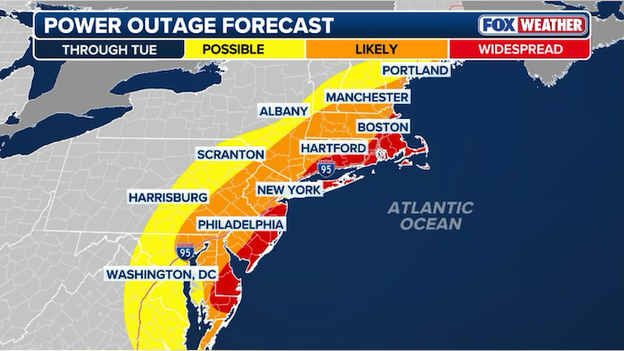
Power outage forecast from FOX Weather showing widespread outages expected along the Northeast coastline.
The combination of the wet, heavy snow and snow rates of 1 to 3 inches per hour will place immense stress on the power grid.
Utility crews are on standby across the region, but travel bans and whiteout conditions may prevent them from reaching damaged lines until the storm subsides on Monday afternoon.
Camera showing heavy, wet snow now falling in Rehoboth Beach, Delaware as the storm ramps up.
The transition has officially hit the coast, and Rehoboth Beach, Delaware is now seeing a steady, heavy coating of wet snow as the nor'easter kicks into high gear.
While the day started with light rain, the rapidly strengthening nor'easter is now pulling in colder air, turning precipitation into thick, heavy flakes that are quickly sticking to the boardwalk and streets.
Forecasters warn that this heavy, wet consistency poses a double threat: it makes the roads exceptionally slick and places immense weight on power lines and tree branches.
Residents should prepare for conditions to worsen dramatically tonight as snow rates could exceed 2 inches per hour, accompanied by wind gusts reaching up to 50 mph.
Camera showing snow flying and visibility dropping in and around Philadelphia.
The FOX Forecast Center says conditions will deteriorate in Philadelphia over the next few hours as snow begins to add up.
Cameras show snow flying in the city and temperatures are now dropping, so the snow will begin to stick as we approach sunset.
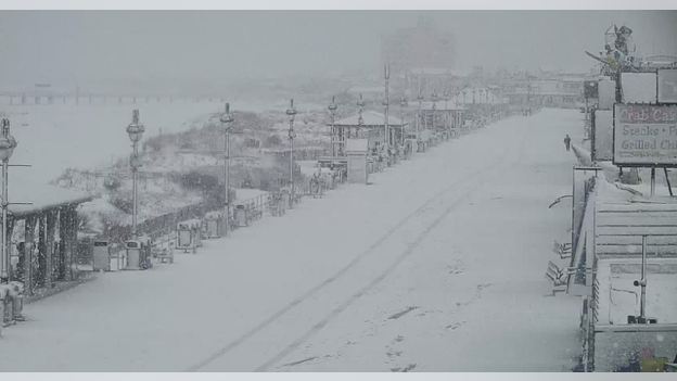
Ocean City, New Jersey Boardwalk covered in snow.
The iconic Ocean City, New Jersey Boardwalk is now completely blanketed in snow as the nor'easter intensifies along the Jersey Shore.
This rapid accumulation comes as the FOX Forecast Center warns of snow rates exceeding 2 inches per hour and wind gusts up to 60 mph through Monday.
The massive bomb cyclone slamming the Northeast has effectively paralyzed air travel across the United States.
As of 3:15 p.m. ET today, FlightAware reports more than 12,400 U.S. flights have already been disrupted through Tuesday.
FlightAware reports more than 8,300 U.S. flights have been canceled through Tuesday.
The scale of the cancellations is staggering, with 8,353 U.S. flights wiped off the boards so far and an additional 4,064 flights facing significant delays.
Major hubs including JFK, LaGuardia, Newark, and Boston Logan are seeing near-total shutdowns as blizzard conditions make safe takeoffs and landings impossible.
Travelers are strongly urged to check their flight status from home rather than heading to the airport, as many terminals are dealing with massive crowds and limited services.
As New York City prepares for its first historic blizzard in nearly a decade, DoorDash has announced the activation of its Severe Weather Protocol.
To ensure the safety of its workers and the community, DoorDash will temporarily suspend all operations across the five boroughs starting at 8:30 p.m. ET tonight.
We're suspending operations early to keep Dashers safe and off the streets before the travel ban takes effect. We're closely monitoring conditions and will resume as soon as it's safe to do so.
The company is deliberately shutting down 30 minutes before the citywide travel ban begins to ensure all active deliveries are completed and Dashers are safely off the roads before the 9:00 p.m. ET street closures.
Operations are currently scheduled to remain suspended until at least 12:00 p.m. ET on Monday.
As the 2026 Nor’easter intensifies, Governor Kathy Hochul and the MTA have officially announced that all Long Island Rail Road (LIRR) service will be suspended system-wide starting at 1:00 AM on Monday, February 23.
While Metro-North is currently attempting to maintain hourly service, the severity of the blizzard conditions on Long Island—where snow totals are projected to hit 18–24 inches—has made it unsafe to continue rail operations.
The latest analysis from the FOX Forecast Center shows the nor'easter rapidly intensifying as it moves off the Mid-Atlantic coast.
Radar imagery highlights a critical zone of intense rising air stretching from Washington through Philadelphia and toward New Jersey.
This atmospheric "lift" is a primary signal that a rapid changeover from rain to heavy, accumulating snow is imminent for the I-95 corridor.
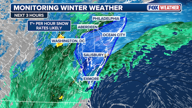
The FOX Forecast Center is monitoring a heavy snow band developing that will produce 1"/hour snow rates.
Meteorologists are currently monitoring a high-impact mesoscale band where snow rates are expected to explode. The most intense activity is currently focused within a triangular corridor encompassing Salisbury, Ocean City, Aberdeen, and Philadelphia.
Locations as far south as Exmore, Virginia and as far north as Philadelphia are seeing this transition now, which will lead to rapidly deteriorating visibility and slick roads.
As the center of the low-pressure system continues to strengthen, these heavy snow bands will march northward, setting the stage for the life-threatening blizzard conditions expected across New York City and New England tonight.
The Ocean State is officially under a State of Emergency.
With a major nor’easter bearing down on New England, Governor Dan McKee has issued an emergency declaration ahead of what is expected to be a significant blizzard event.
The National Weather Service has issued a Blizzard Warning for all of Rhode Island, effective from 4:00 p.m. today, Sunday, February 22, through tomorrow.
Some communities could get crushed by more than 2 feet of snow and here's how it'll happen. The FOX Forecast Center has identified specific "jackpot zones" where localized mesoscale banding will turn a major storm into a generational event.
While the entire I-95 corridor is in the crosshairs, the highest confidence for record-shattering totals is now concentrated along the coast.
- The Jersey Shore: This region is currently the prime target for the storm’s highest totals, with forecasts now painting nearly 3 feet of snow. Intense snow bands are expected to set up here, dumping 2 to 4 inches of snow per hour during the storm's peak Sunday night.
- Long Island & Coastal New England: Central and eastern Long Island, along with the immediate Massachusetts coast, are also bracing for more than 24 inches as the storm bombs out over the Atlantic benchmark.
- Major metro hubs: New York City, Philadelphia, and Boston have all been upgraded to the 18–24 inch range as model confidence surges for a historic burial. If a mesoscale band parks itself over one of these cities, more than 2 feet of snow could bury millions.
Exclusive FOX Weather Model showing intense bands of snow setting up from Boston to Philadelphia on Sunday night.
The difference between a foot of snow and a jackpot 24-inch-plus total often comes down to mesoscale banding.
These narrow ribbons of extreme snow are notoriously difficult to predict; they can stall over a single county, leading to local maxima that far exceed surrounding areas.
However, with Blizzard Warnings now covering nearly 35 million people, the margin for error is shrinking: even the low end of this forecast qualifies as a major, life-threatening event.
As the blizzard begins to impact the region with heavy snow, Metro-North Railroad has announced significant service adjustments for tomorrow.
On Monday, the railroad will operate on an hourly service schedule across its main lines. Additionally, all branch lines will operate on a weekend schedule to accommodate the challenging conditions and lower ridership expected during the blizzard.
While these changes are slated for Monday, Metro-North warns that service may also be impacted today as the snow intensifies.
Commuters are strongly encouraged to check the MTA website or the TrainTime app before heading to the station and to allow for significant extra travel time due to the hazardous weather.
Despite the intensifying blizzard conditions across the city, the Staten Island Ferry will continue to operate, albeit on a modified schedule to ensure the safety of all passengers and crew.
Starting at midnight tonight, the ferry will switch from its standard weekend frequency to an hourly schedule.
Service is expected to ramp up slightly in the morning, with half-hour service currently planned to resume at 6:00 a.m. Monday.
Travelers are reminded that a citywide travel ban remains in effect until noon tomorrow, and New York City Emergency Management has issued a Hazardous Travel Advisory for the duration of the storm.
Please allow significant extra travel time and exercise extreme caution when navigating terminals and boarding vessels.
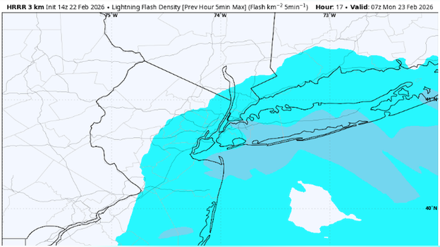
Lightning has been detected in the rapidly strengthening storm off the Delmarva.
Meteorologists have detected lightning strikes off the Delmarva coast this afternoon, a powerful signal that the developing nor'easter is undergoing rapid intensification.
This lightning is a "signature" of extreme atmospheric instability and strong upward motion, often indicating that the storm is bombing out and preparing to unleash intense mesoscale snow bands.
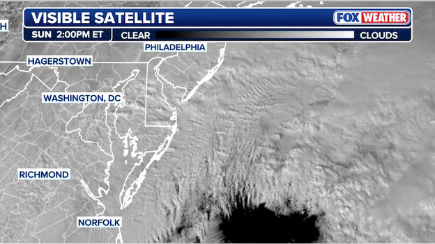
Visible satellite shows gravity waves rippling through the atmosphere over the Atlantic Ocean.
Visible satellite imagery today has captured a rare and striking meteorological phenomenon: atmospheric gravity waves rippling away from the center of our intensifying nor'easter.
Often compared to the ripples created by throwing a stone into a pond, these waves form when stable air is violently displaced—in this case, by the explosive intensification of the storm's core.
The FOX Forecast Center is closely monitoring these "ripples in the sky," as they are a clear physical signature of a storm undergoing rapid bombogenesis.
While gravity waves are often invisible to the naked eye, they become visible on satellite when moisture condenses into thin, parallel cloud bands at the wave's crests.
Their presence today signals extreme turbulence in the upper atmosphere and serves as a precursor to the intense snowfall rates and hurricane-force wind gusts expected to lash the coast tonight.
FOX Forecast Center meteorologists say we've reached a critical turning point in the storm's development.
As the low-pressure system (marked with a red "L") moves off the coast, it is beginning to tap into powerful atmospheric dynamics.
The orange-dashed region highlighted by the FOX Forecast Center identifies an area of intense rising air stretching from Washington through Philadelphia and toward New York City.
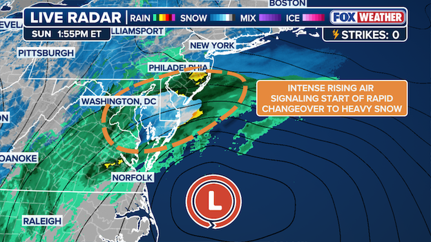
Radar analysis from FOX Weather shows the storm is beginning to transition into a full-blown nor'easter.
This rapid upward motion is a "signature" signal for meteorologists, indicating that the atmosphere is priming itself for an immediate and rapid changeover to heavy snow.
While some coastal areas are currently seeing rain or a mix, this intense lift will soon cause temperatures to crash, turning the precipitation entirely to snow.
Once this transition occurs, residents in the I-95 corridor should prepare for snow rates of 1 to 3 inches per hour, which will lead to near-zero visibility and life-threatening blizzard conditions by this evening.
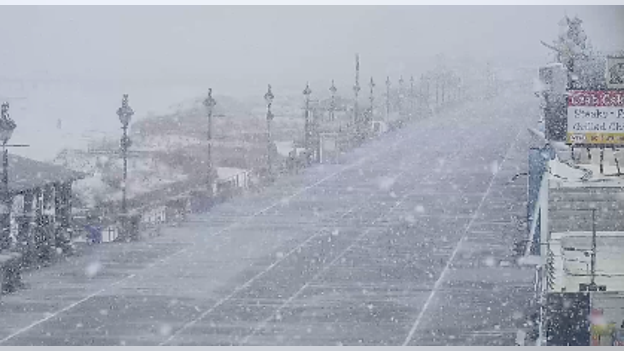
Camera showing huge snowflakes flying on the Ocean City, New Jersey Boardwalk.
While much of the region is still waiting for the first real flakes to stick, the signature of this monster nor'easter is already being spotted along the coast.
Huge, silver-dollar-sized snowflakes have been reported falling along the Ocean City, New Jersey Boardwalk, signaling a rapid transition as cold air begins to wrap into the strengthening bomb cyclone.
Though the ground is still relatively warm from recent mild temperatures, these massive flakes are a precursor to the intense snow rates expected tonight.
As of 1:00 p.m. ET, LaGuardia Airport is the only official reporting site in the region to record measurable snow, clocking in at 0.3 inches while other major hubs like Central Park and JFK report only a trace.
Meteorologists at NWS Upton say they expect these accumulations to ramp up rapidly after sunset as surfaces cool, setting the stage for the storm’s most dangerous impacts tonight.
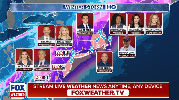
FOX Weather is deploying a team of meteorologists and correspondents across the Northeast ahead of the blizzard.
FOX Weather is providing LIVE, around-the-clock coverage of Blizzard '26. With more than a dozen crews deploying into the storm, this is the place for the most comprehensive storm coverage.
Our team of meteorologists and correspondents will be Weathering It Together with you, reporting on the latest LIVE developments as the storm unfolds.
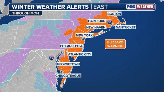
Blizzard Warnings are now in effect for more than 38 million Americans in the Northeast.
The threat level for the Northeast has jumped significantly as Blizzard Warnings were just expanded across Connecticut and Massachusetts.
As of this afternoon, more than 38 million Americans now find themselves under a Blizzard Warning, stretching from the Mid-Atlantic all the way through New England. 4 whole states: New Jersey, Connecticut, Rhode Island, and Delaware are now under the extreme warning.
Forecasters warn that this massive expansion reflects increasing confidence in the storm’s "bombogenesis," which will trigger whiteout conditions and near-hurricane-force wind gusts through Monday.
In these areas, residents are being urged to prepare for snow rates of up to 3 inches per hour, which could result in more than 2 feet of total accumulation in the hardest-hit coastal areas.
As a massive nor'easter rapidly develops into a bomb cyclone off the East Coast, the governors of New York, New Jersey, Connecticut, Rhode Island, and Massachusetts have all declared states of emergency.
These declarations come as meteorologists warn of a "signature storm" that could rank among the top ten snow events in the region's history, with more than 38 million people now under blizzard warnings.
The state of emergency status allows these states to mobilize National Guard units, activate emergency operations centers, and implement strict travel bans to keep motorists off life-threatening roads.
Mayor Cherelle Parker has declared a Disaster Emergency for Philadelphia, effective immediately, as the city braces for a major winter storm predicted to dump between 18 and 24 inches of snow.
The declaration, made in coordination with Governor Josh Shapiro, grants the city enhanced powers to mobilize all available resources—including over 1,000 workers and 800 pieces of equipment—to protect residents and clear critical routes.
In addition to the Disaster Emergency, a formal Snow Emergency and parking ban will go into effect at 4:00 PM today. Residents must move their vehicles from the city's 110 miles of designated Snow Emergency routes to avoid being ticketed and towed.
With the heaviest snow expected overnight and into Monday morning, all Philadelphia public schools will operate on a fully virtual schedule tomorrow to keep students and staff off the dangerous roads.
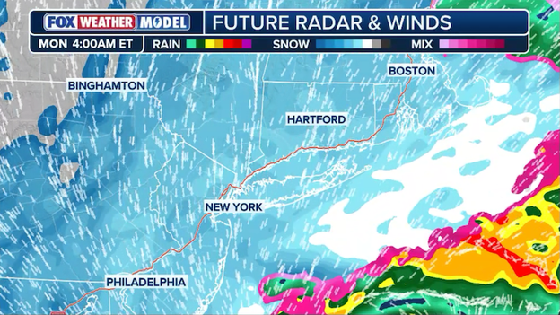
The FOX Forecast Center is warning New Yorkers that while the snow may currently seem manageable, the most dangerous part of the storm comes overnight.
Intense atmospheric lift just north of the storm's center is expected to trigger incredible snow rates across the New York Metro area overnight.
Forecasters say snow rates of over 1 inch per hour are a certainty, with the storm likely hitting its peak intensity between 2:00 a.m. and 6:00 a.m.
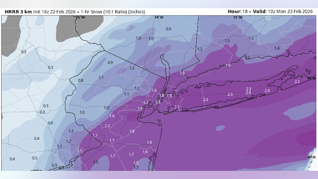
High Resolution Rapid Refresh (HRRR) model showing 1-3" per hour snow rates overnight in and around New York City.
During this early morning window, snow rates could reach a staggering 3 inches per hour, creating a wall of snow that will quickly bury city streets.
The FOX Forecast Center notes that by the time people wake up on Monday morning, there may already be a full foot of snow on the ground. With visibility dropping to near zero and winds gusting over 50 mph, travel will be impossible during this peak period.
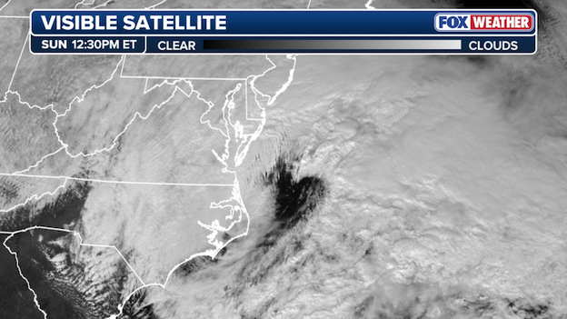
Visible satellite image showing the center of low pressure beginning to spin up off the U.S. East Coast.
Visible satellite imagery captured minutes ago shows the nor'easter rapidly organizing and off the East Coast as it prepares to slam the Northeast with historic snow.
The FOX Forecast Center is tracking the storm's explosive development in real-time as all the atmospheric ingredients align for a life-threatening blizzard tonight.
NJ Transit says it is suspending service ahead of the storm to prioritize safety as New Jersey braces for the blizzard.
To ensure the safety of both customers and employees, the agency is urging residents to travel only if absolutely necessary. Those who must travel should expect slippery conditions at all stations and build extra time into their schedules to account for potential delays.
NJ Transit has announced the following major service changes beginning tonight:
- Buses: All NJ Transit bus service will be suspended effective 6:00 p.m.
- Light Rail: All light rail lines (Newark, Hudson-Bergen, and River LINE) will also be suspended starting at 6:00 p.m.
- Access Link: Service will be suspended at 6:00 p.m.
- Rail service: The Princeton Dinky is currently suspended due to engineer availability issues related to the ongoing Portal Bridge project; substitute bus service is being provided. Other rail lines are currently operating but may face additional suspensions as the storm intensifies.
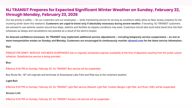
NJ Transit website showing the latest service changes and suspensions.
Conditions are changing rapidly, and additional service adjustments or total suspensions are possible on Monday. Commuters are encouraged to continuously monitor njtransit.com or use the NJ Transit mobile app for real-time "My Transit" alerts.
It may look like a typical, quiet winter afternoon right now with snow barely beginning to stick, but meteorologists warn that this is the "calm before the storm".
Conditions are expected to deteriorate rapidly with terrifying speed as the bomb cyclone intensifies off the coast this evening.
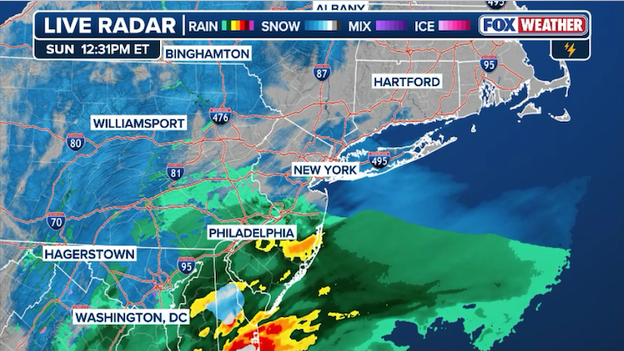
Latest radar image showing where rain is mixing with snow during the initial stages of the storm.
What starts as light rain or flurries will rapidly transform into a life-threatening blizzard tonight, with snow rates reaching 2 to 3 inches per hour and wind gusts screaming up to 70 mph.
By the time the sun goes down, visibility will drop to near zero, creating a total whiteout that makes travel not just difficult, but impossible.
Northeast state leaders say if you are not already at your final destination, you are running out of time to get there safely.
Tonight isn't just about shoveling; it's about survival as the combination of heavy, wet snow and hurricane-force gusts threatens to snap trees and trigger widespread power outages while the mercury plunges.
Governor Ned Lamont has officially declared a state of emergency for Connecticut as a major nor'easter bears down on the state with blizzard conditions.
As part of this emergency declaration, all commercial vehicles—including tractor-trailers, tankers, and RVs—are prohibited from traveling on limited-access highways statewide starting at 5:00 p.m. today.
The Governor is strongly urging all residents to finish essential errands early and stay off the roads for the duration of the storm to allow plow crews to work safely.
FlightAware MiseryMap showing the total flight disruptions throughout the Northeast today.
The number of U.S. flight disruptions has officially crossed the 10,000 mark as a historic bomb cyclone brings major travel hubs to a standstill.
Data from FlightAware confirms that as of midday, the U.S. aviation system has logged over 7,640 cancellations and more than 2,780 delays through Tuesday.
Major carriers—including JetBlue, Delta, and American Airlines—have preemptively scrubbed thousands of flights through Tuesday to prevent crews and aircraft from being trapped in the storm's path.
The most severe impacts are concentrated at Northeast gateways like JFK, Newark, and Boston Logan, where blizzard conditions will make runway operations impossible.
Most airlines have issued extensive travel waivers, and travelers are strongly urged to confirm their flight status online rather than heading to the airport.
The U.S. House of Representatives has officially postponed critical votes to end the current partial government shutdown from Monday to Tuesday.
As a historic bomb cyclone slams the Northeast, travel conditions across the D.C. area will become increasingly hazardous, leading leadership to adjust the legislative schedule for the safety of members and staff.
This delay comes as the shutdown, which began on February 14, enters its ninth day.
The Department of Homeland Security remains the primary agency affected by the impasse as lawmakers continue to debate controversial reforms to immigration enforcement.
In a rare and historic move, New York City Mayor Zohran Mamdani has officially declared a State of Emergency and instituted a citywide travel ban as the blizzard begins to paralyze the region.
The Mayor announced that all city streets, highways, and bridges will be closed to non-emergency traffic starting at 9:00 p.m. tonight and remaining in effect until 12:00 p.m. Monday.
This blanket restriction applies to all vehicles, including cars, trucks, scooters, and e-bikes, with narrow exemptions granted only for essential emergency movements and critical service workers.
With forecast models predicting up to 24 inches of snow and wind gusts reaching 60 mph, officials are taking these extreme steps to prevent motorists from becoming stranded and to allow the city's fleet of 2,600 sanitation workers to clear life-saving routes without obstruction.
Suffolk County Executive Ed Romaine has issued a 24-hour travel ban as Long Island prepares for potentially historic snow totals.
The mandatory ban takes effect at 9:00 p.m. tonight and will remain in place until 9:00 p.m. Monday.
While most residents are required to stay off the roads, the ban does not apply to essential workers and plow operators.
Executive Romaine stated this decisive action is necessary to ensure visibility for road crews and to protect lives as the storm transitions quickly from rain to heavy snow bands and damaging winds.
The New Jersey Department of Transportation (NJDOT) has issued mandatory commercial vehicle travel restrictions on several major interstate highways, effective at 3:00 p.m. today.
The restrictions, coordinated with neighboring states, apply to all tractor-trailers, empty straight CDL-weighted trucks, passenger vehicles pulling trailers, recreational vehicles, and motorcycles in both directions until further notice.
Mayor Michelle Wu has declared a snow emergency for the City of Boston as a major nor'easter, expected to bring historic snow and blizzard conditions, begins to hammer the region.
During a recent press conference, the Mayor warned that the city is facing dangerous travel conditions through Monday, characterized by heavy snow and powerful winds. To prioritize public safety, all Boston Public Schools and central offices will be closed on Monday.
Mayor Wu emphasized that city teams are already pre-treating roads, but the intensity of the storm makes staying off the roads essential. Residents are encouraged to stay inside, check on vulnerable neighbors, and visit boston.gov/snow-parking for a full list of restricted streets and available garage space.
Nearly 10,000 flights have been disrupted as a massive blizzard bears down on the Northeast, paralyzing travel from Philadelphia to Boston.
According to FlightAware, at least 7,200 U.S. flights have been canceled, with 2,200 more delayed as the bomb cyclone creates life-threatening conditions.
FlightAware reports thousands of flights have been canceled at NYC's major airports.
Major hubs—including JFK, Newark, and Boston Logan—have become ghost towns as airlines proactively scrubbed schedules to keep planes and crews out of the storm's path.
With snow rates of up to 3 inches per hour and 60 mph wind gusts expected to continue through Monday, travelers are being urged to check their status before leaving home.
Most major carriers have already issued travel waivers, allowing passengers to rebook without penalty as the aviation network prepares for a ripple effect of delays that could last well into the week.
The Broadway League has issued a critical weather update on behalf of its members, announcing the cancellation of shows for Sunday night.
Broadway matinee performances scheduled for 3 p.m. or earlier today will proceed as originally planned.
However, due to anticipated travel impacts and evening travel bans already announced for surrounding areas, Broadway theatre owners and producers have reached a consensus to cancel all evening performances with curtain times at 6 p.m. or later tonight.
For all other shows, theatergoers should contact their original point of purchase directly with any questions regarding exchange or refund policies.
Notably, as of 10:30 a.m., the production of Operation Mincemeat has not yet canceled its evening performance.
Governor Josh Shapiro announced that state teams are working around the clock to prepare for the intensifying storm as blizzard warnings expand into Southeastern and Northeastern Pennsylvania.
With heavy snow expected to continue through Monday, the Governor urged residents to stay off the roads, prioritize safety, and follow local officials for real-time updates.
Governor Kathy Hochul has deployed a specialized all-terrain rescue vehicle to Long Island to bolster the state's blizzard response efforts.
This powerhouse of a vehicle can transport more than 20 people and is set to assist local emergency crews with vital search and rescue operations during the height of the storm.
Governor Ned Lamont has scheduled an emergency press briefing for 3 p.m. today as Connecticut prepares for a historic blizzard that could dump up to two feet of snow across the state.
The Governor is expected to provide critical updates on the state's emergency response and safety protocols as wind gusts exceeding 50 mph begin to sweep through the region.
Westchester County, New York has announced a mandatory road ban as the bomb cyclone prepares to deliver its heaviest blow tonight.
Following guidance from the New York State Division of Homeland Security and Emergency Services, the ban will take effect at 9:00 p.m. tonight, and remain in place until 10:00 a.m. Monday.
During this window, all roads are closed to everyone except essential emergency travel, including police, fire, and ambulance services.
Officials are implementing this drastic measure because travel conditions are expected to be treacherous to impossible due to the combination of heavy snow and high winds.
By staying off the roads, residents ensure that emergency crews and plows can operate safely and effectively during the peak of the storm.
NOAA's Winter Storm Severity Index showing "extreme" impacts for Boston through Monday.
Meteorologists at the National Weather Service in Boston are raising the alarm for a potentially historic and destructive period for communities southeast of the Boston-Providence corridor.
As the bomb cyclone intensifies, the primary threat in these areas is the dangerous combination of heavy, wet snow and ferocious northeast wind gusts reaching 60 to 70 mph.
This specific region is at high risk for widespread power outages and significant tree damage as the weight of the water-logged snow puts immense strain on infrastructure already battered by near-hurricane-force gusts.
Forecasters warn that the most life-threatening conditions will occur from 4:00 a.m. to noon on Monday, making any travel during the morning commute nearly impossible and highly discouraged.
Even the animals are hunkering down for this one.
The Wildlife Conservation Society (WCS) has announced that all five of its New York City parks—the Bronx Zoo, Central Park Zoo, Prospect Park Zoo, Queens Zoo, and the New York Aquarium—will be closing early at 2:00 p.m. today.
Due to the forecasted heavy snow and blizzard conditions, the parks will also remain completely closed on Monday.
While the gates will be locked to the public, WCS says essential animal care and operations staff will stay on-site to ensure all residents are safe, warm, and fed during the bomb cyclone.
This proactive closure aligns with Mayor Mamdani’s urge for New Yorkers to stay home and off the roads as the storm intensifies this afternoon.
If you were planning a snowy stroll through the penguin exhibit, you'll have to wait until the jackpot snow bands pass and crews can safely clear the pathways.
You've seen the insane snow totals and the bone-rattling winds, but let's chat about one of winter's most dramatic (and surprisingly common) phenomena in a bomb cyclone: thundersnow!
If you hear a rumble of thunder during this blizzard, you're not imagining things—and it's a sure sign you're right in the heart of the storm's nastiest snow bands.
Simply put, thundersnow is exactly what it sounds like: thunder and lightning happening during a snowstorm. But it's not your typical summer thunderstorm. Instead of warm, humid air creating big, booming updrafts, thundersnow occurs when there's an unusually steep temperature drop with height in the atmosphere, creating instability.
Imagine warm, moist air trying to rise very quickly through much colder air above it—it's like a mini-supercell, but with snow. This creates the charge separation needed for lightning and the subsequent thunder. Because snow dampens sound, thundersnow often sounds more like a muffled rumble than a sharp crack.
The most intense thundersnow events are often found in the "deformation zone" or the wrap-around precipitation shield of a rapidly intensifying low-pressure system—which is exactly what we have with this bomb cyclone.
- Coastal New Jersey & Long Island: These areas, already in the jackpot zone for 24+ inches of snow, are prime candidates. The storm will be at its most powerful and rapidly deepening directly offshore, creating the perfect conditions for instability within those heavy snow bands.
- Southern New England (especially near the coast): As the storm tracks up the coast, the sharp temperature gradients and strong lift will make thundersnow a real possibility for places like Boston and coastal Massachusetts.
- Heavy mesoscale bands: Anytime you have those narrow, incredibly intense snow bands dumping 2-4 inches per hour, keep an ear out. These are the sweet spots for localized thundersnow.
High Resolution Rapid Refresh (HRRR) model showing where lightning may strike overnight near New York City. (Source: WeatherBELL)
So, if you're hunkered down tonight and you hear a distant rumble, don't be alarmed (unless it's the sound of your roof groaning under the snow). It just means you're experiencing one of winter's coolest, and most intense, meteorological marvels.
Mayor Zohran Mamdani joined FOX Weather on Sunday morning to issue a stark warning to New Yorkers, emphasizing that "staying home means you are staying safe" as the historic bomb cyclone intensifies.
With blizzard conditions threatening the city with up to 20 inches of snow and life-threatening whiteouts, the Mayor told FOX Weather meteorologist Nick Kosir that all residents should hunker down and avoid the roads entirely until the storm passes on Monday.
Mayor Zohran Mamdani tells FOX Weather that a final decision on whether New York City Public Schools will pivot to remote learning on Monday will be made by noon today.
While traditional snow days are a thing of the past due to state instructional requirements, families are being urged to monitor official channels for the definitive call on in-person versus virtual classes.
New York City Mayor Zohran Mamdani recently joined FOX Weather meteorologist Nick Kosir to discuss the city's mobilization efforts as a historic blizzard brings up to 24 inches of snow to the five boroughs.
During the interview, Mayor Mamdani emphasized that while travel will become extremely hazardous, there is currently no plan to shut down the public transit system as the MTA works around the clock to keep subways and buses moving.
Thousands of flights have been canceled ahead of the blizzard bomb set to blast the Northeast today.
The nation’s aviation network is grinding to a standstill as a generational bomb cyclone slams into the Northeast, with more than 8,000 flights disrupted across the country.
As of Sunday morning, FlightAware reports the total number of scrapped trips includes 6,800+ full cancellations and hundreds of delays through Tuesday.
Major hubs like New York (JFK and LaGuardia), Newark, Philadelphia, and Boston are bearing the brunt of the impact, with carriers like JetBlue canceling 40% of their Sunday schedule to avoid stranding aircraft and crews in the storm’s jackpot zones.
The disruptions aren't limited to domestic travel; international giants have taken the rare step of canceling all Monday flights to and from New York and Newark.
With blizzard conditions bringing near-zero visibility and 70 mph wind gusts, airports will struggle to maintain safe runway operations.
If you are one of the thousands affected, most major airlines—including Delta, American, United, and Southwest—have waived change and cancellation fees, allowing you to rebook your travel through the middle of next week without penalty.
If you’re looking out your window right now at puddles and grey skies, it might be hard to believe that a historic, two-foot snow event is just hours away.
For many in the Mid-Atlantic and Northeast, Sunday morning has brought a deceptive period of light rain or a slushy mix, fueled by daytime temperatures hovering just above freezing.
But don't let the wet pavement fool you—this is the calm before the bomb cyclone truly explodes.
Exclusive FOX Weather Model showing heavy snow developing along I-95 by nightfall.
FOX Weather meteorologists warn that as the storm bombs out and rapidly intensifies offshore later today, it will begin to drag a wall of arctic air into the region, flipping that rain to heavy snow from north to south.
For major cities like New York City, Philadelphia, and coastal New Jersey, the rain is expected to transition to all snow through the afternoon and early evening.
By nightfall, the transition will be complete for nearly the entire I-95 corridor. This is when the storm's most dangerous phase begins, with snow rates potentially hitting 1 to 3 inches per hour.
This initial period of rain is actually a major concern for the jackpot zones. The moisture is soaking the ground and any early accumulation, making the eventual snowpack incredibly heavy and wet.
When the 60–70 mph wind gusts arrive later tonight, that water-logged snow will act like a lead weight on tree limbs and power lines, significantly increasing the risk of widespread, prolonged outages.
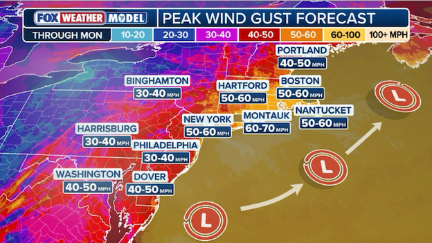
Exclusive FOX Weather Model showing 60-70 mph peak wind gusts from the nor'easter.
The bomb cyclone isn't just a snow-maker; it’s a high-octane wind machine.
As the storm’s central pressure plummets today, the FOX Forecast Center is warning of damaging wind gusts that will create life-threatening whiteout conditions and likely trigger widespread power outages across the Northeast.
While the snow totals are grabbing the headlines, the wind is what will make this storm truly dangerous for anyone caught outdoors.
Peak wind gust forecast through Monday:
- Montauk: 60–70 mph (gusts to 75 mph possible)
- New York City: 50–60 mph
- Boston: 50–60 mph
- Hartford: 50–60 mph
- Philadelphia: 30–40 mph
- Washington: 40–50 mph
The most extreme winds are expected along the immediate coast, where gusts could top 70 mph as the "L" (low pressure) center tracks just offshore.
When these ferocious winds hit the expected 2-foot snow totals, visibility will drop to near zero in seconds.
Residents are urged to secure loose outdoor items and prepare for the possibility of being without power for several days as the combination of heavy, wet snow and tropical-storm-force gusts puts immense strain on the grid.
While Philadelphia, New York City, and Boston brace for a historic two-foot burial, Washington, D.C., and Baltimore appear to be dodging the bomb cyclone's lethal punch.
The National Weather Service (NWS) Baltimore/Washington has notably opted against issuing Blizzard Warnings for the immediate metro areas, instead keeping Winter Storm Warnings and Advisories in place.
The primary reason for the miss is the storm's projected track, which is expected to bomb out just a bit too far east to pull the heaviest snow bands directly over the District.
Additionally, marginal surface temperatures in the mid-30s during the day on Sunday will cause much of the initial precipitation to fall as rain or a slushy mix, effectively "wasting" several hours of potential accumulation.
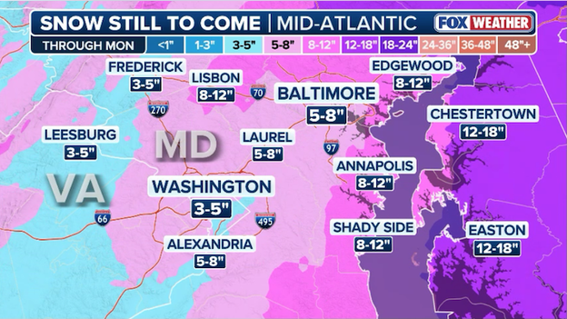
Latest snow forecast from FOX Weather showing where the heaviest snow will fall around Washington and Baltimore.
Despite missing the jackpot totals, the region isn't entirely off the hook. Baltimore is still expecting a respectable 5 to 8 inches of snow, with some areas north and east of the city potentially seeing up to 12 inches as the storm intensifies late Sunday night.
Meanwhile, D.C. residents should plan for a more modest 3 to 5 inches (maybe even less), mostly accumulating on the grass as temperatures struggle to hit the freezing mark before the steadiest moisture pulls away.
While D.C. won't be shoveling two feet of snow tomorrow morning, the combination of gusty 35 mph winds and rapidly dropping temperatures this evening will still make for a treacherous Monday morning commute.
Amtrak has initiated massive service adjustments across its busiest corridor as the nor'easter brings life-threatening conditions to the Northeast.
In consultation with meteorologists and local officials, the carrier says it is proactively canceling trains on Sunday and Monday to protect passengers and equipment from 60 mph wind gusts and localized snow totals of up to two feet.
While Amtrak has not released a final tally of individual train numbers, the modifications are widespread, impacting the Northeast Regional, Acela, and various Keystone Service routes.
The rail agency emphasized that these "proactive measures" are designed to limit exposure to hazardous conditions and support state-issued travel bans currently in effect across New York and New Jersey.
Impacted customers are being notified directly via email or text; however, all travelers are urged to check their train status on the Amtrak mobile app before heading to the station.
Philadelphia is officially in the crosshairs of a historic nor'easter as the National Weather Service has issued a Blizzard Warning for the city, the first of its kind in 10 years.
Not since the record-shattering "Snowzilla" of January 2016 has the city faced a winter alert of this magnitude, which signals a dangerous combination of heavy snow and sustained wind gusts of 50 to 60 mph, creating life-threatening whiteout conditions.
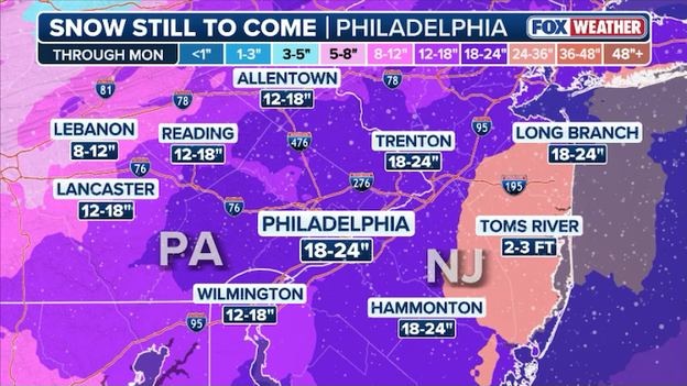
Latest snow forecast from FOX Weather showing up to 2 feet for Philadelphia.
Mayor Cherelle Parker has already declared a snow emergency, warning residents that near-blizzard conditions will make travel extremely difficult to impossible through Monday.
The storm is expected to "bomb out" off the coast, potentially dumping 18 to 24 inches of snow on the city.
While the day begins with a slushy mix, a sharp drop in temperature this evening will flip the precipitation to all snow, leading to intense rates of 1 to 2 inches per hour overnight.
With visibility expected to drop below a quarter-mile and power outages a high probability, officials are urging all Philadelphians to be home by sunset and stay off the roads to allow crews to manage this generational event.
There is no "off-season" for the fearless crews of the 53rd Weather Reconnaissance Squadron. Known as the Hurricane Hunters, these Air Force Reserve and NOAA pilots have swapped tropical heat for arctic air, flying their specialized WC-130J Super Hercules and Gulfstream IV aircraft directly into the developing nor'easter to gather critical, real-time data.
By dropping GPS instruments called dropsondes from altitudes as high as 45,000 feet, they are sampling the atmosphere's temperature, pressure, humidity, and wind speed in regions where satellites and ground stations simply can't reach.
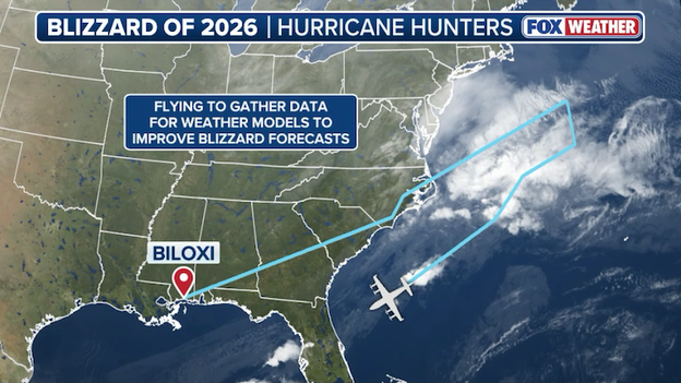
Hurricane Hunters' flight path into the developing nor'easter along the East Coast.
This mission is the secret weapon for forecasters trying to nail down the impossible track of this historic blizzard. The high-resolution data retrieved by the planes is fed directly into the American (GFS) and European (ECMWF) weather models, helping to resolve the "model mayhem" that saw snow predictions jump from a few inches to over two feet in mere hours.
By capturing the exact moisture levels and wind fields offshore, these flights are providing the linchpin data needed to issue more accurate Blizzard Warnings and potentially save lives across the Northeast.
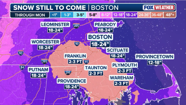
Latest snow forecast from FOX Weather showing more than 2 feet of snow near the Boston metro area through Monday.
Boston is currently under a Blizzard Warning as it prepares for a historic bomb cyclone that could dump between 18 and 24 inches of snow across the metro area.
With the storm intensifying later tonight, the city is bracing for life-threatening travel conditions, 60 mph wind gusts, and significant coastal flooding.
Mayor Wu has declared a snow emergency and implemented a parking ban to assist road crews, while officials urge residents to hunker down and prepare for potential widespread power outages caused by the heavy snowfall and extreme winds.
There is a spooky numerical trend that has New York City meteorologists scratching their heads: nearly every all-time record-breaking blizzard in the city has occurred in a year ending in the number 6.
This 10-year interval has turned the mid-winter months of 1996, 2006, and 2016 into legendary milestones for weather enthusiasts and a nightmare for city transit.
As we find ourselves in 2026, the pattern seems to be holding firm as yet another historic bomb cyclone takes aim at the I-95 corridor.
To understand the scale of what is currently brewing, we have to look back at the big three storms that defined the last three decades:
- January 1996 (The Blizzard of '96): This massive nor'easter paralyzed the Eastern Seaboard for nearly a week. Central Park recorded 20.2 inches of snow, while other boroughs saw up to 30 inches. The storm was so intense it forced the New York Stock Exchange to close early and left thousands across the region without electricity or heat for days.
- February 2006: Just 10 years later, a minor affair turned into a record-shattering event. It dumped 26.9 inches on Central Park in a single 16-hour period—the highest total recorded since 1869 at that time. Snow fell at staggering rates of 3 to 4 inches per hour, causing subway delays and cutting bus service in half.
- January 2016 (Snowzilla): Keeping the "sixes" streak alive, the storm became the most significant storm in NYC history. It dropped an all-time record 27.5 inches of snow in Central Park. The storm prompted a total travel ban for all NYC and Long Island roads, proving that even with modern preparation, a 10-year monster storm can still bring the "city that never sleeps" to a complete standstill.
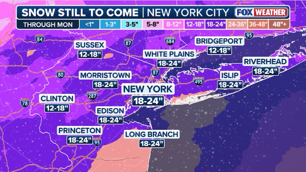
Latest snow forecast from FOX Weather showing up to 2 feet of snow for New York City through Monday.
With Blizzard Warnings once again hoisted for the five boroughs this weekend, it appears the "10-year curse" is right on schedule. Whether it's a quirk of atmospheric cycles or just meteorological coincidence, the Northeast is once again bracing for a generational event that could join the ranks of '96, '06, and '16 in the record books.
History is unfolding in the Garden State as the National Weather Service (NWS) has placed the entire state of New Jersey under a Blizzard Warning.
According to NWS Mount Holly, this marks the first time in exactly 30 years—stretching back to the legendary Blizzard of 1996—that such a widespread, top-tier winter alert has covered all 21 counties simultaneously.
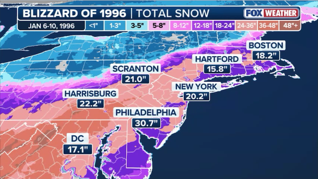
The Blizzard of 1996 buried the Northeast in more than 2 feet of snow.
While coastal regions have seen more recent warnings, this universal declaration underscores the extreme nature of the bomb cyclone currently bearing down on the region.
The NWS transition from Winter Storm Warnings to a blanket Blizzard Warning follows a surge in confidence that sustained winds or frequent gusts of 60 mph will combine with snow rates of 2 to 3 inches per hour to create life-threatening conditions.
During the 1996 event, the state was similarly paralyzed by over two feet of snow and record-shattering drifts that shut down the New Jersey Turnpike for the first time in its history.
With current forecasts predicting up to 24 inches for some jackpot zones, Governor Sherrill has echoed the gravity of the moment, urging all residents to treat this as a potentially historic threat to life and property.
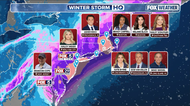
FOX Weather is deploying a team of meteorologists and correspondents across the Northeast ahead of the blizzard.
FOX Weather is providing LIVE, around-the-clock coverage of Blizzard '26. With more than a dozen crews deploying into the storm, this is the place for the most comprehensive storm coverage. Our team of meteorologists and correspondents will be Weathering It Together with you, reporting on the latest LIVE developments as the storm unfolds.
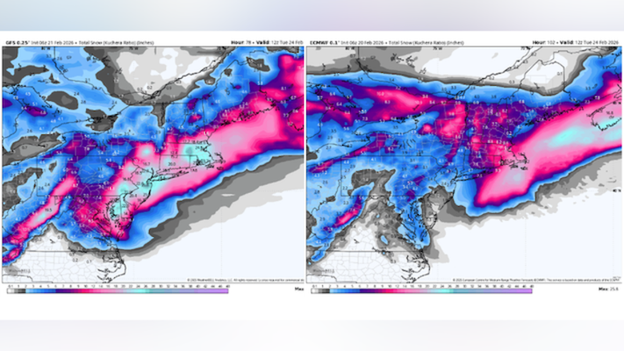
Global computer models (GFS and ECMWF) disagreed on the storm's track and expected snow amounts.
Leading up to this weekend's historic blizzard, even the world's most sophisticated computer models found themselves in a state of model mayhem as they struggled to pin down the storm's volatile track.
Just days before the first flakes fell, major global systems like the European (ECMWF) and the American (GFS) were locked in a stark disagreement that left meteorologists baffled.
While the GFS was sounding the alarm for a record-shattering "biggest storm of all time" with potential three-foot totals, the European model—historically considered the most accurate global predictor—was calling for a much weaker system that would largely head out to sea.
The primary challenge for these digital guides was capturing the rare and explosive phasing of two separate energy systems from the Great Lakes and the Southeast and the final track of the storm's center.
Most reliable models initially failed to realize these systems would merge at full speed, creating an atmospheric energy blast that redefined the storm's magnitude in mere hours.
Additionally, because models are only as good as the data they receive, small miscalculations in the initial temperature and moisture levels can lead to wildly different answers.
This high-stakes uncertainty meant that even a minor shift of 50-100 miles in the projected track was the difference between a "nothing" event and a crippled I-95 corridor.
If you went to bed on Friday thinking this was just a nuisance storm and woke up to a 24-inch nightmare, you aren't alone—and neither are the computers.
This wasn't just a forecast miss; it was a masterclass in atmospheric chaos.
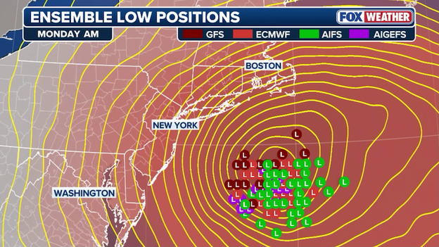
Numerous reliable computer forecast models initially struggled to accurately capture the track and magnitude of the storm.
Here is the breakdown of how the Blizzard of '26 went from a disorganized mess to a generational monster in under 48 hours.
The perfect (or worst) track: Earlier in the week, most weather models took the storm's center far away from the U.S. coast. That lead to initial predictions of a light-snow event for the I-95. When the storm's individual pieces got closer and computers were able to accurately model it's eventual path, snow amounts took a serious turn. Now, the center of the storm is projected to track directly over or just southeast of the 40°N/70°W benchmark. This specific set of coordinates is considered the sweet spot for classic New England nor'easters, as it allows the storm to pull in maximum moisture from the Atlantic while keeping the I-95 corridor on the cold, snow-heavy side of the system.
Bombogenesis: With the right ingredients in play, storm will undergo bombogenesis—the "bomb" in bomb cyclone. To be a bomb, a storm’s central pressure must drop 24 millibars in 24 hours. This one won't just meet the criteria; it will demolish it, dropping pressure like a rock. As the pressure plummets, the storm begins to spin more violently, pulling in massive amounts of moisture from the warm Gulf Stream and slamming it into a wall of arctic air.
The "mesoscale" headache: The real reason your local total might have jumped from 6 inches to 24 is a phenomenon called mesoscale banding. These are narrow, high-intensity ribbons of snow—often just 10 to 20 miles wide—that can dump 3 to 4 inches of snow per hour while a town just a few miles away sees significantly less. Models struggle to pinpoint exactly where these bands will set up until the storm is literally on top of us.
Factor in a high snow-to-water ratio (where cold air turns a little moisture into a lot of fluffy snow), and you have the perfect recipe for a forecast that "busts" toward the extreme.
The blizzard has brought the nation's aviation network to its knees, with 7,300 U.S. flights already disrupted as of Sunday morning.
Mass cancellations are piling up across the Northeast, with over 6,630 flights scrapped through Tuesday as airports in New York, Boston, and Philadelphia prepare for a total whiteout.
Airlines have effectively surrendered to the blizzard’s 70 mph gusts, grounding fleets to prevent planes and crews from being stranded in the jackpot zones of the I-95 corridor.
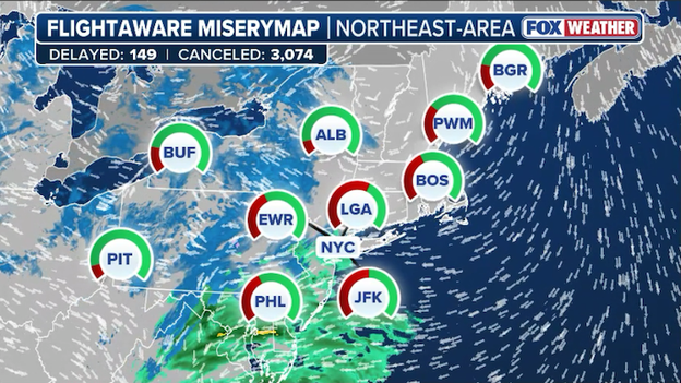
FlightAware MiseryMap showing the widespread flight disruptions across the Northeast today.
Major carriers including American, Delta, United, Southwest, and JetBlue have proactively issued travel waivers for the Northeast ahead of the storm.
These alerts cover a broad range of airports from D.C. to Boston, allowing passengers scheduled to fly on Sunday, February 22, and Monday, February 23, to rebook their flights without paying change fees or fare differences.
If you have travel plans through the middle of the week, the message is clear: check your app, stay home, and prepare for a long road to recovery once the snow finally stops.
Governors Kathy Hochul (NY) and Mikie Sherrill (NJ) have officially declared States of Emergency as the Northeast braces for the full fury of a historic bomb cyclone.
In New York, the National Guard has been activated to stand watch over 22 counties while a strict commercial travel ban takes hold of I-84 and all southern routes starting at 4:00 p.m. ET.
Governor Hochul is urging residents to hunker down before the storm's 60 mph gusts turn the landscape into a blinding whiteout that could make even a short trip life-threatening.
Across the Hudson, Governor Sherrill has placed all 21 New Jersey counties under high alert, warning that the Garden State is in the crosshairs of a generational event.
With coastal communities staring down the barrel of a potential two-foot snow burial, the state is prepping for the inevitable snap of power lines and falling trees as 60 mph winds lash the region through Monday morning.
Both leaders are emphasizing a single, urgent message: finish your preparations now and stay off the roads to give emergency crews the space they need to battle this monster storm.
The FOX Forecast Center has significantly increased its snow predictions as a powerful "bomb cyclone" prepares to blast the East Coast.
Widespread accumulations of 12 to 24 inches are now expected along the I-95 corridor from Philadelphia to Boston through Monday.
Forecast confidence is surging for a historic event, with models now painting more than two feet of snow for parts of the Jersey Shore and Long Island.
FOX Forecast Center snow totals through Monday
- Jersey Shore: 2 feet+
- Boston: 18–24"
- New York City: 18–24"
- Philadelphia: 18–24"
- Baltimore: 5-8"
- Washington: 3-5"
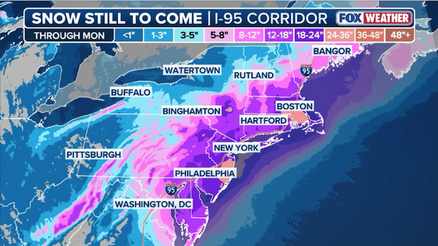
Latest snow forecast from FOX Weather showing more than 2 feet of snow for the Jersey Shore along the coast to Boston.
The heaviest snow is set to arrive Sunday night into Monday morning, with intense mesoscale bands potentially dumping 2 to 4 inches of snow per hour in localized "jackpot" zones.
Combined with wind gusts between 50 and 70 mph, these totals will lead to total whiteout conditions and life-threatening travel.
Residents are urged to complete all preparations immediately, as the weight of this heavy snow combined with extreme winds is likely to trigger widespread power outages throughout the region.
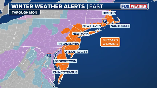
Blizzard Warnings are in effect from Boston to New York to Philadelphia to Maryland, covering much of the I-95 corridor.
The Northeast is bracing for a historic atmospheric assault this morning as nearly 30 million Americans find themselves under rare Blizzard Warnings.
From the mid-Atlantic coast up through New England, the National Weather Service is warning of a "potentially life-threatening" event as a rapidly intensifying bomb cyclone prepares to dump 12 to 24 inches of snow along the I-95 corridor.
In New York City, this marks the first Blizzard Warning issued in nine years, underscoring the severity of a system that could bring snow rates of 2 to 3 inches per hour and wind gusts up to 60 mph.
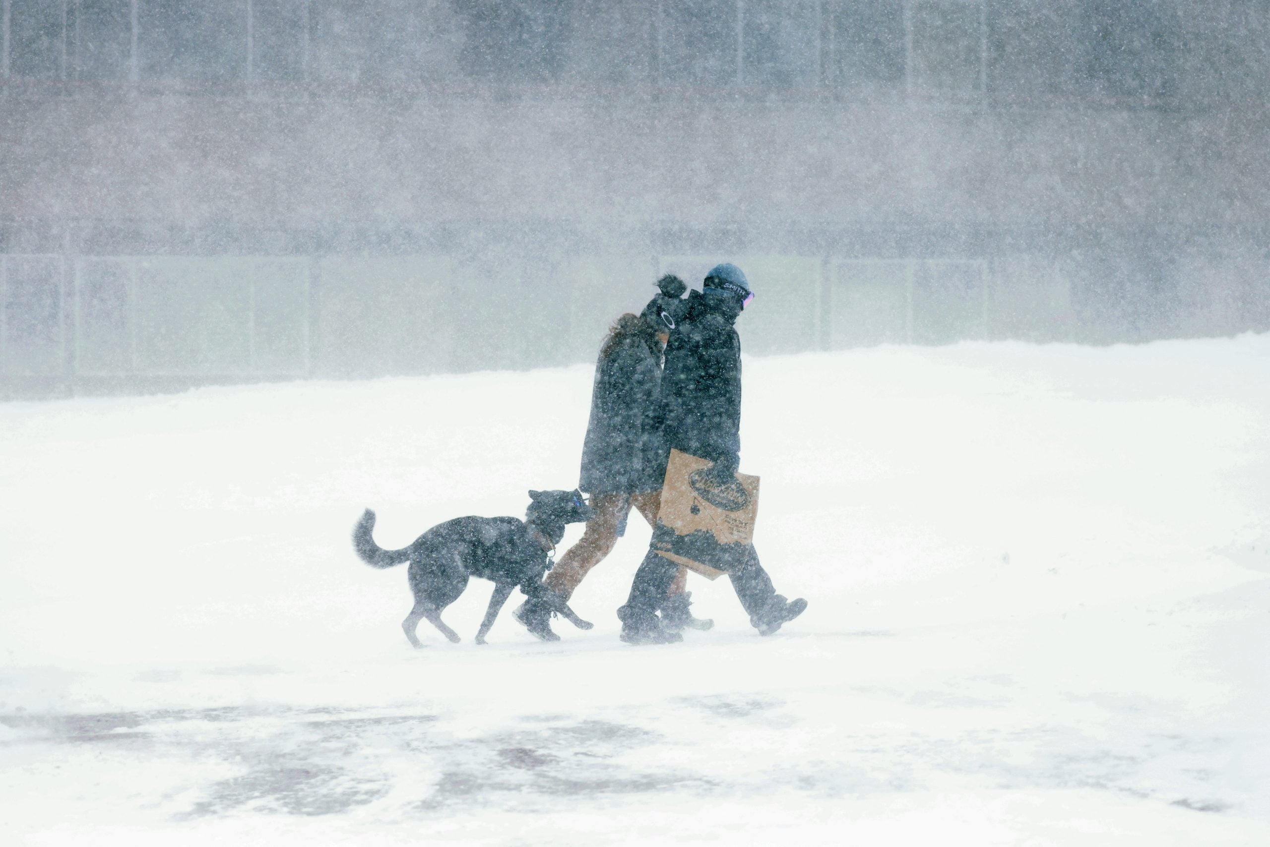
As the storm "bombs out" over the Atlantic tonight, visibility is expected to drop to near zero, making travel dangerous, if not impossible through Monday afternoon.
Governors in New York and New Jersey have already declared States of Emergency, with major transit hubs like Philadelphia and Boston preparing for total whiteout conditions and widespread power outages.
With the heaviest snow set to arrive Sunday night, officials are urging the millions in the storm's path to finish all preparations immediately and stay off the roads to allow emergency crews room to work.
Don't miss out: you can go back and see LIVE updates from Saturday's coverage of this historic blizzard.
Click here to see the minute-by-minute updates from FOX Weather.
You’ve reached the beginning of this live coverage.