Live updates: Deadly blizzard 'bomb' paralyzes Northeast in extreme snow, power outages
Live updates: Deadly blizzard 'bomb' paralyzes Northeast in extreme snow, power outages
Download the AppLIVE Winter Storm HQ coverage continues from FOX Weather
View postCoverage for this event has ended.
FOX Weather is your Winter Storm HQ, providing around-the-clock live coverage to help keep your family safe.
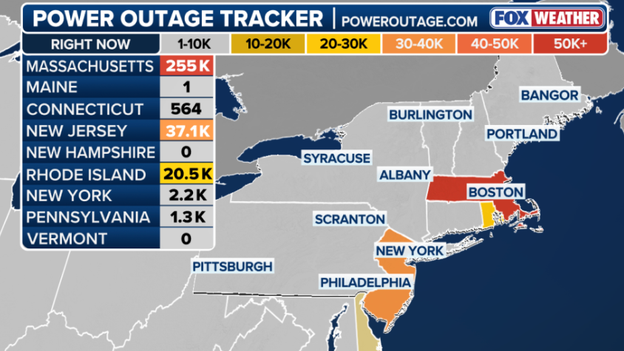
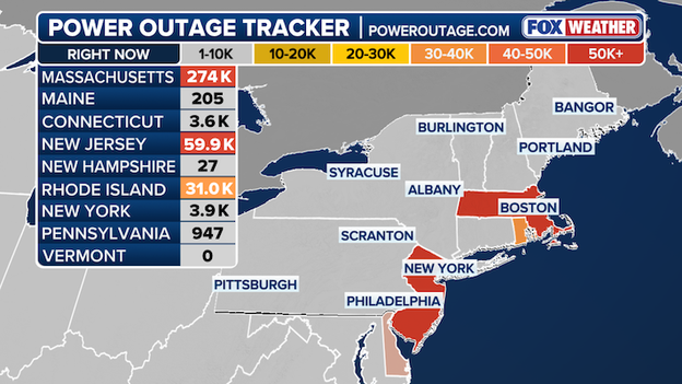
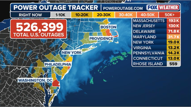
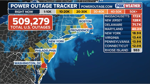
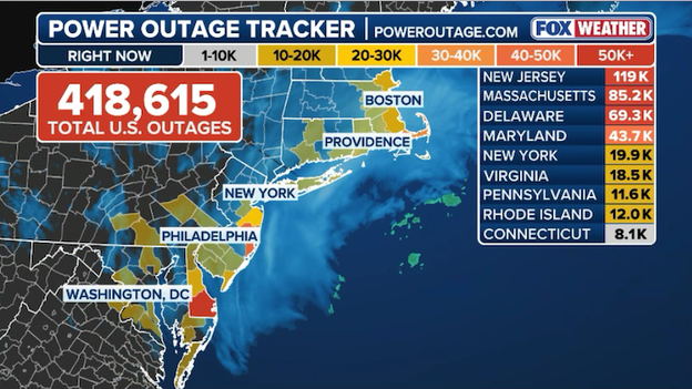
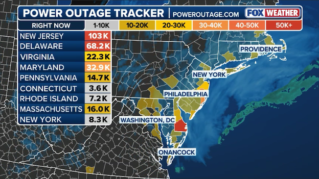
Live look at power outages across the Northeast as of Tuesday morning
The power crisis across the Northeast is entering day two, with outages impacting over 350,000 customers following the worst of the historic blizzard yesterday.
Data from PowerOutage.com shows the states most impacted from the storm's hurricane-force wind gusts and heavy, wet snow.
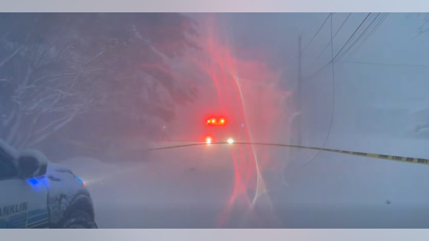
Courtesy: Franklin (MA) Fire Department
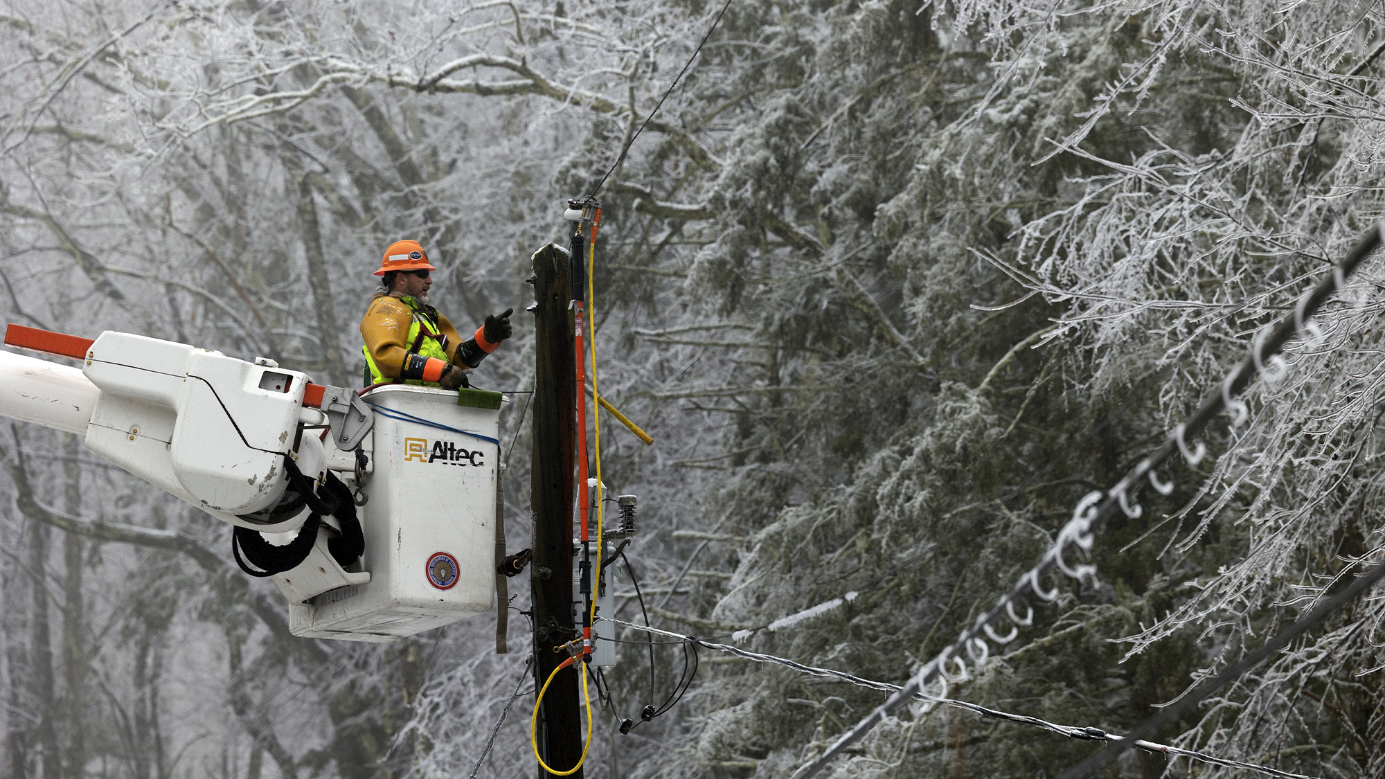
After the deadly blizzard tore through the Northeast knocking out power to hundreds of thousands Americans, scenes like this were left in its wake of the dangerous threat of dangling live power lines. Watch the full video here.
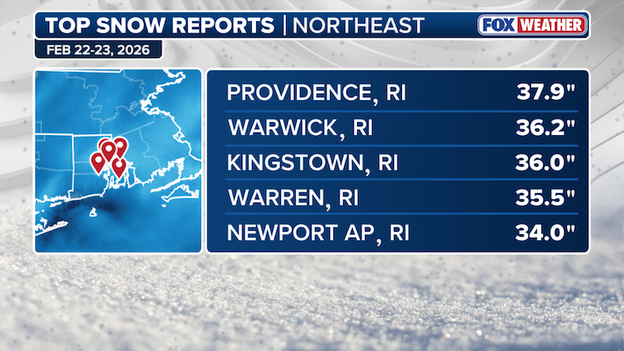
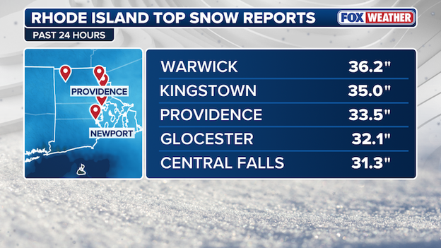
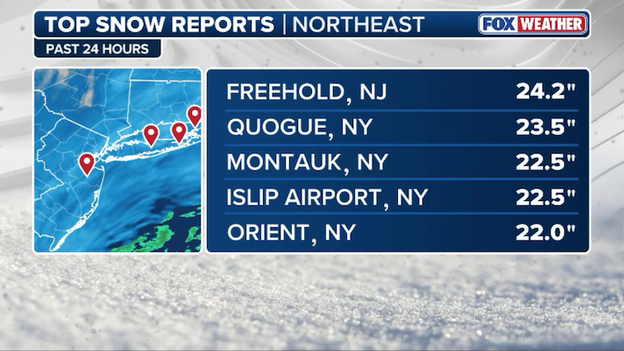
Map shows the highest snow totals for the Northeast, notably all in Rhode Island
The rankings are in. See how some major East Coast cities stacked up after the Blizzard of 2026:
Providence, RI 37.9" (state record)
Newark, NJ 27.2"
Central Park 19.7” (9th biggest storm on record)
Boston 17.1”
Philadelphia 14.0"
Hartford, CT 9.0”
Baltimore 2.1"
The National Weather Service has issued a special weather statement warning of black ice across the Northeast.Black ice is a thin, transparent layer of ice that forms on road surfaces, sidewalks or bridges that can turn a simple drive or walk into a dangerous situation in seconds.
It is extremely dangerous because it provides little to no traction, and it is nearly impossible for drivers or pedestrians to see until they are already on it.Drivers and pedestrians should be on the lookout for black ice through the evening and into the Tuesday morning commute, especially on any untreated surfaces.
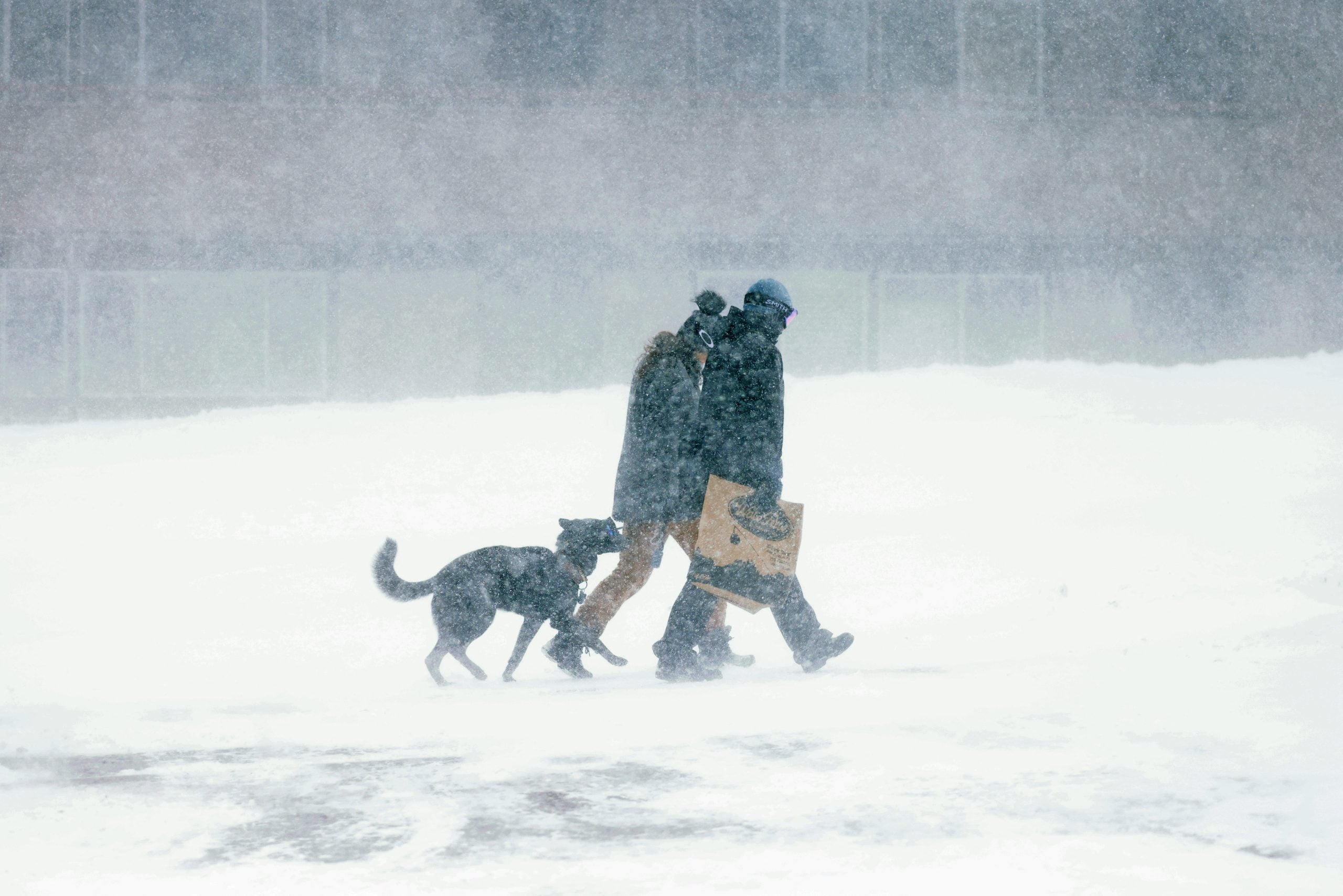
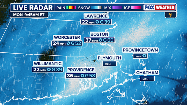
Parts of the Northeast were battered by hurricane-force wind gusts as the historic nor’easter roared up the coastline, turning heavy snow into blinding whiteout conditions and triggering widespread damage concerns.
The strongest gust recorded so far was in Newport, where winds screamed to 89 mph — well into hurricane-force territory.
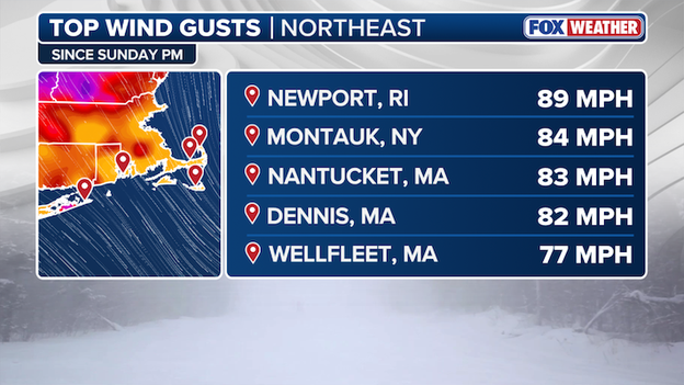
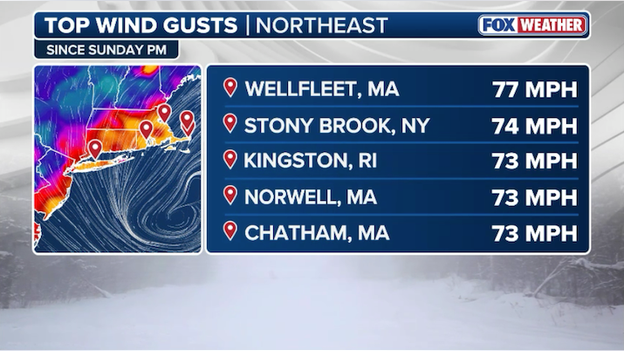
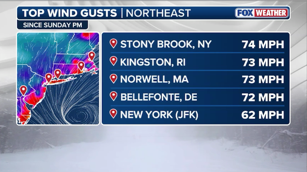
Top wind gusts in the Northeast
Farther west on Long Island, Montauk clocked an 84 mph gust as the powerful coastal storm intensified.
In Massachusetts, Nantucket reported an 83 mph wind gust, while Dennis saw winds peak at 82 mph. Wellfleet also endured punishing conditions, with gusts reaching 77 mph. These dangerous wind gusts, combined with heavy snow, have paralyzed much of Massachusetts where there are over 200,000 power outages statewide.
The extreme wind speeds registered along the Northeastern coast underscore the ferocious nature of this historic nor’easter, which combined intense snowfall with damaging coastal winds to created blizzard conditions and dangerous travel across the region.
As the worst of the historic Blizzard of 2026 is in the rearview, lets take a look at the top snow totals in the Northeast.
Rhode Island is digging out after the historic nor’easter unleashed the biggest snowfall totals seen anywhere in the Northeast from the monster storm, with several communities buried under more than three feet of snow.
Top Snow Reports in the Northeast from the historic nor'easter
Leading the way is Providence, where a record-demolishing eye 37.9 inches of snow, smashing the previous record of 28.6" set during the Blizzard of 1978.
Two other Rhode Island towns also snuck in the the 3-foot snow total. Warwick picked up 36.2 inches, while South Kingstown also measured an even 36.0 inches.
Heavy bands continued to hammer coastal communities in Rhode Island, with Warren tallying 35.5 inches and Newport reporting 34.0 inches at the airport.
These staggering totals underscore the crippling impact the powerful nor’easter had across Rhode Island, where prolonged snowfall rates and strong winds combined to create blizzard conditions and bring travel to a standstill.
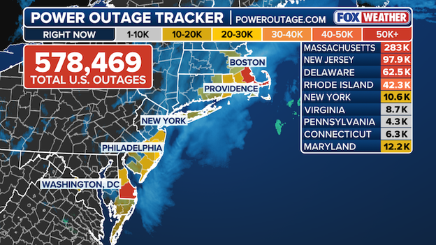
According to data from poweroutage.com, power outages have stalled in Massachusetts as more than 270,000 across the state remain without power.
Power Outage Tracker sponsored at poweroutage.com.
In Barnstable County on Cape Cod, 85.92% of customers tracked in the county are without power, as outages are total over 150,000 in the coastal county alone.
86.24% of customers on Nantucket Island remain without power.
Other hard-hit states, including New Jersey, Rhode Island, Delaware and Maryland, have managed to chip away at outages over the past several hours, but more than 140,000 customers across the four states are still without power.
The National Weather Service has issued a special weather statement warning of black ice across the Northeast.
Black ice is a thin, transparent layer of ice that forms on road surfaces, sidewalks or bridges that can turn a simple drive or walk into a dangerous situation in seconds.
It is extremely dangerous because it provides little to no traction, and it is nearly impossible for drivers or pedestrians to see until they are already on it.
Drivers and pedestrians should be on the lookout for black ice through the evening and into the Tuesday morning commute, especially on any untreated surfaces.

The City of Boston said public schools will be closed on Tuesday as the city works to clean up from today's massive snowstorm.
"Due to the ongoing snow emergency and continued snow removal in the City of Boston, all Boston Public Schools will remain closed through Tuesday, Feb. 24, and school is canceled for the day," the city said on social media.
Here are the official snow reports as of 7 p.m. ET from the National Weather Service:
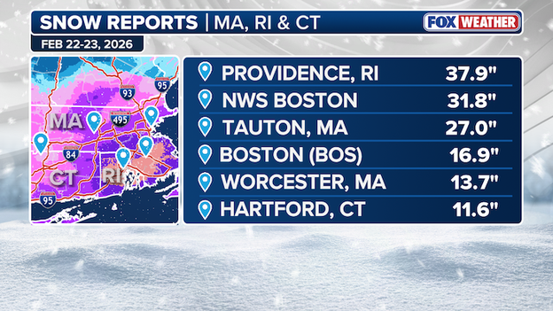
Providence, Rhode Island, received over 37 inches of snow.
As snow fell in the Poconos last night, teams from Pennsylvania Department of Transportation, Pennsylvania Emergency Management, Pennsylvania State Police and the Pennsylvania Health Department coordinated through the blizzard to safely transport a newborn baby to the Children's Hospital of Philadelphia for emergency care.
Governor Josh Shapiro wrote on X, "This is an incredible example of how we make government work — and I'm so proud of the dedicated public servants in my Administration who come together every day to deliver for the good people Pennsylvania."
Massachusetts Governor Maura Healey has included Martha's Vineyard in a travel ban issued earlier today, and activated 150 more National Guard members for the storm response in the areas hit hardest by the historic nor'easter.
The travel ban issued for Bristol, Plymouth and Barnstable counties remains in effect and Governor Healey is extending the ban to Dukes County, home to Martha's Vineyard.
“While the worst of the storm is behind us and much of the state is turning to shoveling out, conditions remain severe and dangerous across Southeastern Massachusetts,” said Governor Healey.
The executive order places a ban on non-essential motor vehicle travel across the four counties. Additionally, the speed limit on the Mass Pike has also been reduced to 40 miles per hour.
“We need everyone to stay off the roads for their own safety and to allow our crews to do their work – especially in Bristol, Plymouth, and Barnstable counties and on the Vineyard," Governor Healey said.
A total of 350 National Guard members have been activated to assist in recovery efforts across the state, paying extra attention to Southeastern Massachusetts, where the crippling impact of the historic nor'easter has dealt significant blows to utility as over 280,000 across the state are without power, according to data from poweroutage.com.
The governor has partially lifted a state of emergency for Berkshire, Hampden, Hampshire and Franklin counties. The state of emergency continues in effect for all other counties in the state.
New Jersey Department of Transportation (NJDOT) officials announced the commercial vehicle travel restriction was lifted effective at 5 p.m. for all highways.
In addition, the Emergency Traffic Regulation Order that temporarily lowered all posted speed limits to 35 miles per hour will be lifted at the same time.
In a post on X, New Jersey Governor Mikie Sherrill wrote, "We still strongly urge residents to stay off the roads and stay inside, as conditions remain dangerous and crews are still working to clear the roads."
With over 275,000 customers without power in Massachusetts, over 236,000 outages are Eversource customers, triggering the utility company to dispatch extra crews to service the areas hit hardest.
Power Outage Tracker using data from poweroutage.com
Nearly 1,000 Eversource line, tree and service crews are a part of a massive restoration effort as a slow-moving, long-duration nor’easter continues to impact Massachusetts, bringing blizzard conditions, heavy, wet snow, strong winds and extremely hazardous travel, especially across eastern Massachusetts and the Cape.
The majority of outages so far are concentrated on the Cape and other coastal areas, where the storm’s impacts have been most severe.
“This is a slow-moving, long-duration storm, and the difficult travel conditions we’re seeing, especially on the Cape, are making restoration more challenging,” said Eversource President of Massachusetts Electric Operations Doug Foley in a press release.
The National Weather Service has cancelled Blizzard Warnings that spread across the New York City area a little over an hour early as the worst of the storm is in the rearview.
While there may be a few snow showers lingering this evening, accumulating snowfall has largely ended for the New York City area.
The NWS, said that winds have weakened enough to allow for widespread blizzard conditions to end, though there may be isolated instances of blowing snow reducing visibility through the night.
Though it may look it, FOX Weather Exclusive Storm Tracker Brandon Copic is not in Antarctica.
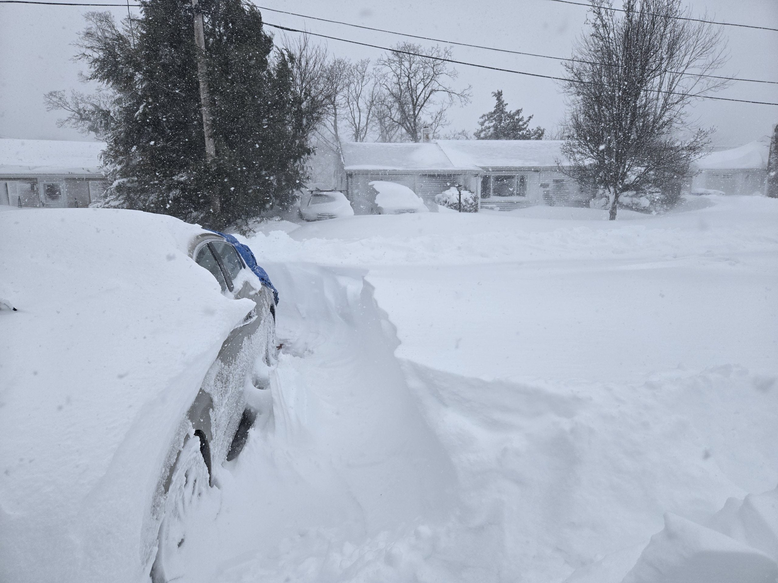
Several cars remain stranded in Plymouth, Massachusetts as hurricane-force wind gusts and heavy snow bury the area.
The Massachusetts coast is being hammered by a monster nor’easter, with blizzard conditions bringing travel to a standstill.
As of 2:15 p.m. EST, Plymouth has already received 20" of snow, and totals are expected to rise as the storm continues to pound the Northeast.
While the snow is winding down, the cancellations are stacking up.
Now, more than 11,000 U.S. flights have been canceled through Tuesday.
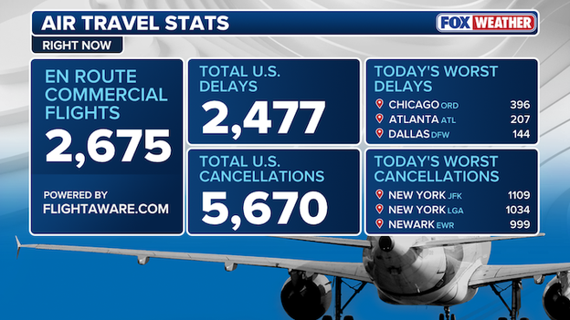
Air Travel Stats right now according to data from Flightaware.com
FlightAware reports nearly 1,900 U.S. flights are already canceled for Tuesday as airlines struggle to reposition aircraft and crews following the Blizzard of 2026.
With an additional 10,300 delayed flights, the total number of disrupted flights by the storm now tops 21,300.
The first 3 foot snow reading has been recorded in Warwick, Rhode Island as monster nor'easter continues to rewrite history books in the Northeast.
Top Rhode Island Snow Totals
Numerous snow records have been set across the region and in Rhode Island as the historic nor’easter slams much of the state with relentless bands of heavy snow and hurricane-force wind gusts.
New York City Mayor Zohran Mamdani announced that New York City Public Schools will reopen for in-person instruction on Tuesday.
If you're wondering how you'll be able to get around the New York City, the city’s live PlowNYC tracker is now active, and it shows exactly when your block was last cleared by a sanitation plow or salt spreader in real time here.
- Fatalities in Maryland: Officials confirm that two people were killed in Calvert County on Sunday afternoon when a large tree fell and crushed a pickup truck on Route 2 in Sunderland. A third occupant was extricated by emergency crews.
- Historic accumulations: Providence, Rhode Island and Islip, New York officially recorded the most snow in recorded history.
- Official blizzard status: The NWS has confirmed blizzard conditions at 19 reporting sites from New York to Massachusetts, including Central Park and Boston Logan.
- Travel and transit halt: Flight cancellations have surpassed 11,000 nationwide, with over 1,600 already axed for Tuesday as airlines struggle to reposition crews and aircraft.
- Infrastructure damage: More than 600,000 customers are without power across the Northeast. In Delaware, a State of Emergency remains in effect with over 100 roads blocked by debris.
A life-threatening blizzard is blasting millions across the Northeast with heavy snow and intense wind.
The crippling impacts from the monster nor’easter are mounting across the Northeast as historic snow totals continue to pile up across the region.
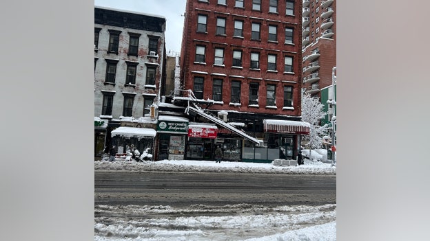
Fire escape damaged in New York City.
New York City remains under siege from the powerful nor’easter, as fierce winds and heavy snow have already shut down transit and strained infrastructure.
At 2nd Avenue & 83rd Street, a toppled fire escape now dangles by a thread over the sidewalk.
Central Park has recorded 19.1" of snow as the monster storm continues to slam New York City and the greater Northeast.
Providence Mayor Brett Smiley provides an update as the historic blizzard lashes Rhode Islands capital with over 30" in the single biggest snow event in the city's storied history.
32.9" has been recorded in Providence as of 1 p.m. EST, smashing the long-standing record of of 30" in Woonsocket during the Blizzard of 1978.
This is nearly matches the annual average snow (36.6") and they will likely surpass a year's worth of snow later today.
Governor Maura Healey has issued a travel ban for South Coast of Massachusetts effective immediately that includes Bristol, Plymouth and Barnstable counties due to the blizzard and dangerous road conditions.
“This is a serious storm, and there are dangerous road conditions out there, especially on the South Coast. We have reports of abandoned and stuck cars on the roads, and tow trucks are having difficulty getting to them,” said Governor Healey.
The executive order places an immediate ban on non-essential motor vehicle travel across the three counties. Additionally, the speed limit on the Mass Pike has also been reduced to 40 miles per hour.
“While this travel ban is limited to the South Coast, we urge everyone across the state to stay off the roads for your safety and for the safety of plow drivers and emergency officials who are trying to do their jobs. Thank you to everyone who has stayed home and to those who are doing this hard work during extremely challenging conditions," Governor Healey said.
The travel ban supports snow removal operations in response to the extraordinary snowfall experienced in the region during this storm so far. Roadway conditions are currently hazardous, and this measure will enhance safety for motorists, plow operators, and first responders.
The travel ban will be lifted when Highway Administrator Jonathan Gulliver determines conditions are safe.
Newark, New Jersey, has officially secured its place in the record books after the "Blizzard of 2026" delivered a massive 27.1 inches of snow to the city.
This staggering total now stands as the second-largest snowstorm in Newark’s history, falling just shy of the all-time record of 27.8 inches set during the legendary January 2016 blizzard.
The 27.1-inch accumulation has completely paralyzed the state's largest city, forcing a mandatory travel ban and leaving thousands without power.
Newark Liberty International Airport (EWR) has been at a near-standstill as crews battle whiteout conditions to clear runways.
This storm has now officially surpassed other historic events, including the famous Blizzard of 1947, which previously held a top spot with 25.5 inches.
For the second consecutive day, the Great White Way has officially shut its doors. The Broadway League announced that all performances scheduled for Monday evening have been canceled due to the ongoing impacts of the historic blizzard and the citywide travel restrictions currently in place.
While most Broadway theaters are typically "dark" on Mondays, several major productions including Chicago, The Great Gatsby, Harry Potter and the Cursed Child, and SIX were forced to scrap their scheduled shows.
The decision marks a rare back-to-back mass cancellation, a move the League has not taken since the 2016 blizzard. This preemptive closure follows Sunday's shutdown of all evening performances, which even included the high-stakes final show for the original British cast of Operation Mincemeat.
Islip, New York, has officially rewritten its weather history with the Blizzard of 2026.
As of 1:00 p.m. today, the National Weather Service recorded a staggering 29.1 inches of snow at Long Island MacArthur Airport, officially crowning this blizzard as the greatest single snowstorm on record for the area.
This monumental total eclipses the previous all-time record of 27.8 inches set during the historic February 2013 blizzard.
Here are the official snow reports as of 1 p.m. ET from the National Weather Service:
- NYC Central Park 19.7"
- Newark 27.1"
- Islip, NY 29.1”
- JFK Airport 19.8"
- LaGuardia Airport 22.2"
- Boston 14.4"
Manhattan's iconic Central Park has officially recorded 19.7 inches of snow as of Monday afternoon, firmly establishing the Blizzard of 2026 as one of the most powerful winter storms in New York City history.
With the 1:00 p.m. measurement showing light to moderate snow still falling, this total has already surpassed the 19.0 inches recorded in 2011, making it the 9th biggest snowstorm ever measured at the park.
The Blizzard of 2026 has officially rewritten the history books for Rhode Island.
As of 1:00 p.m. today, the National Weather Service confirmed that snow at Rhode Island T.F. Green International Airport reached a staggering 32.8 inches.
This monumental total officially breaks the long-standing record for the greatest single snowstorm in Providence history, surpassing the 28.6 inches recorded during the legendary Blizzard of '78.
The record-breaking accumulation comes as the storm's peak intensity centered directly over Kent and Providence counties. The rapid snowfall, which at times exceeded 3 inches per hour, has left the state's primary travel hub completely paralyzed.
While the 1978 storm remained the gold standard for nearly five decades, the Blizzard of 2026 has eclipsed those totals by over four inches, with more snow still expected to be added to the final tally.
Warwick, Rhode Island, officially recorded a massive 31.5 inches of snow, becoming the first location in the Northeast to cross the 30-inch threshold during this historic blizzard.
This record-breaking total cements Warwick as the current epicenter of the storm's accumulation, surpassing previous high marks set earlier this morning in Long Island and Connecticut.
Babylon, New York, has officially reported a staggering 29.5 inches of snow, nearly reaching the three-foot mark as the historic 2026 blizzard delivers its maximum impact to western Suffolk County.
This updated total establishes Babylon as one of the hardest-hit communities in the entire Tri-State area, surpassing other local peaks like Islip's 28 inches.
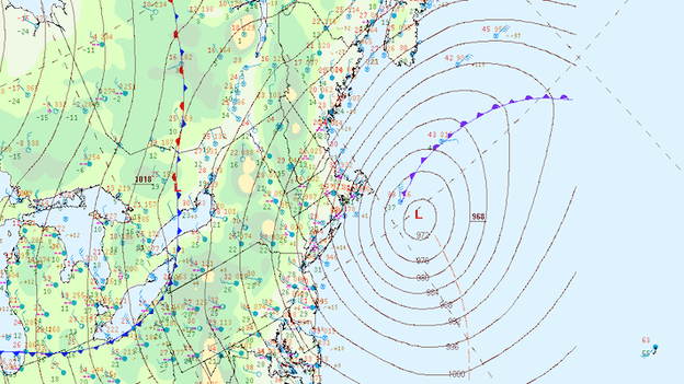
Surface analysis showing the nor'easter along the East Coast and the pressure starting to climb.
The FOX Forecast Center confirms that the Blizzard of 2026 has officially peaked in intensity and is beginning to pull away from the Northeast coast.
After "bombing out" with a staggering minimum central pressure of 966 mb earlier today, surface pressure is now rising, signaling that the storm’s rapid intensification has finally reached its end.
While this is a welcome development, the atmospheric engine remains powerful; the transition to recovery will be gradual as the system slowly loses its grip on the region.
Although the core of the storm is weakening, dangerous conditions will persist through the evening due to a tight pressure gradient.
People should expect continued wind gusts of 40 to 60 mph, which will fuel significant blowing and drifting of the record-breaking snow already on the ground.
While extreme snow rates will begin to taper off from south to north, Blizzard Warnings remain in effect for much of the I-95 corridor until the winds subside enough to restore safe visibility.
Two people were killed near Sunderland, Maryland Sunday afternoon after a tree fell on their car as the nor'easter began to slam the region.
The Calvert County Sheriff's Office said Monday that a third person was trapped inside and was taken to the hospital with critical injuries.
While the worst of the historic blizzard is expected to exit the region tonight, the travel nightmare is far from over.
FlightAware data shows that over 1,600 flights scheduled for Tuesday have already been preemptively canceled as airlines struggle to reset their networks.
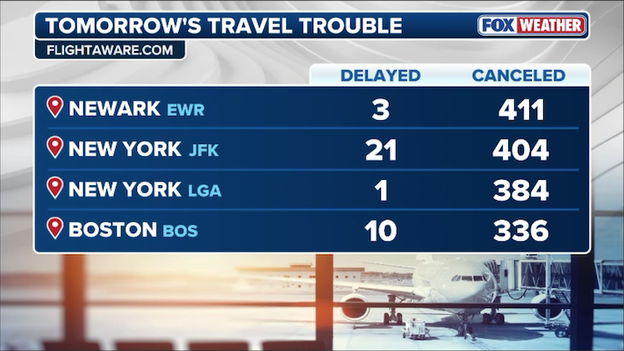
FlightAware data shows hundreds of flights have been canceled at major Northeast airports on Tuesday.
This brings the total number of cancellations since the storm began to well over 10,000, leaving tens of thousands of passengers stranded across the country.
Even with clear skies, travelers at major hubs like JFK, LaGuardia, Newark, and Boston Logan should expect elevated cancellation rates. Right now, planes and flight crews are grounded far from their scheduled Tuesday starting points, requiring a massive logistical "repositioning" effort.
Ground crews must still clear feet of snow from taxiways and hangars, and every departing aircraft will require time-consuming de-icing as temperatures remain frozen.
Low visibility and lingering wind gusts may force air traffic control to maintain larger gaps between takeoffs, significantly reducing the number of flights an airport can handle per hour.
Major carriers including Delta, United, and JetBlue have extended their travel waivers through the end of the week, allowing passengers to rebook for travel as late as February 27 or 28 without paying fare differences. Experts suggest that Wednesday will likely be the first day of truly stabilized operations in the Northeast corridor.
A state of emergency and a travel ban remain in effect across the state.
In response to the historic blizzard currently paralyzing the Northeast, DoorDash has officially extended the suspension of its operations across all five boroughs of New York City until at least 2:00 p.m. ET today.
We're suspending operations early to keep Dashers safe and off the streets.
The company first activated its Severe Weather Protocol on Sunday evening to ensure the safety of its Dashers before the citywide travel ban took effect.
DoorDash spokesperson Julian Crowley noted that the decision was driven by the unprecedented conditions, with snow totals in parts of the city already exceeding 15 to 20 inches and winds gusting up to 60 mph.
As if the snow and wind weren't enough, a new threat is emerging across New York City as millions of New Yorkers venture outdoors.
Falling ice and snow have been reported, threatening those walking amongst the city's skyscrapers. While residents are focused on navigating the record-breaking accumulation—reaching as much as 15 inches in Central Park—the combination of high-rise architecture and intense wind gusts of up to 55 mph is creating a literal "freeze fest" on building facades.
Modern, energy-efficient buildings paradoxically increase the risk of falling ice because their superior insulation keeps the building's exterior colder, allowing ice to anchor more firmly to ledges and awnings rather than melting slowly.
As temperatures fluctuate and winds shift, these frozen projectiles can plummet without warning, causing severe head trauma or other life-threatening injuries.
The National Weather Service has released a staggering summary of damage reports as the bomb cyclone continues to lash New York, New Jersey, and Connecticut. The combination of heavy, wet snow and hurricane-force winds has turned regional travel into a nightmare, with major thoroughfares currently blocked by downed trees and tangled power lines.
Across Long Island, the Department of Highways is battling significant blockages on key routes. In West Hills, all lanes of the Jericho Turnpike are blocked in both directions, while NY 27 near Amagansett and NY 24 near Hampton Bays have both been obstructed by fallen timber. The damage has turned personal in some areas, with reports of trees crushing vehicles in Montauk and Williamsburg.
The impact in New York City and New Jersey has been equally severe, with social media footage documenting widespread damage across Brooklyn & Queens where numerous trees have damaged cars and structures, including a confirmed awning collapse in Elmhurst. In Williamsburg and Bed-Stuy, large trees have completely blocked local streets.
Trees have also obstructed major arteries in New Jersey, including the Garden State Parkway and NJ 17. Jersey City officials report numerous photos and videos of downed trees across the city.
In Connecticut, the danger is compounded by "live" hazards, as many fallen trees have brought down utility wires. Major closures are currently in effect on Route 77, Route 106, and RT 63, as well as RT 15 Southbound in Trumbull. Emergency crews are working through the whiteout conditions, but residents are warned that many secondary roads remain impassable and extremely dangerous.
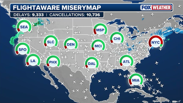
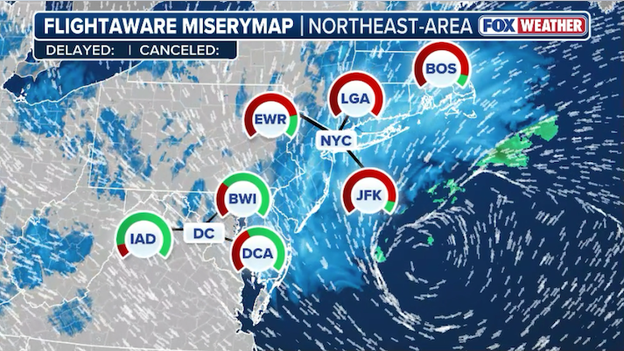
FlightAware MiseryMap showing the total number of disruptions nationwide.
The historic bomb cyclone battering the Northeast has triggered a massive wave of air travel chaos, with total flight disruptions across the U.S. now exceeding 22,000 for the three-day period ending Tuesday.
This staggering figure includes over 10,700 confirmed cancellations and more than 9,300 delays as the region enters what experts are calling a "no-fly zone".
The disruption has spread far beyond the snowy Northeast, as planes and crews remain stranded in blizzard conditions. Major airports in sunnier locales like Orlando (MCO), Tampa (TPA), and Atlanta (ATL) are seeing hundreds of cancellations and delays as their high-frequency connections to the Northeast are severed.
Airlines including Delta, United, JetBlue, and American have issued widespread travel waivers, allowing passengers to rebook through late February without penalty as the industry prepares for a multi-day recovery effort.
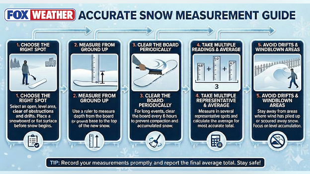
Use this handy guide to accurately measure snow during and after the blizzard.
As the blizzard buries the Northeast in what could be record-breaking totals, many residents are reaching for their yardsticks.
However, getting an accurate reading in a high-wind event like this can be tricky due to significant drifting.
To ensure your reports are useful for meteorologists, follow these official measurement steps:
- Choose the right spot: Select an open, level area clear of obstructions and drifts. Ideally, place a "snowboard" or a flat, white surface down before the snow begins.
- Measure from the ground up: Use a ruler or yardstick to measure the depth from the board (or ground) base to the top of the newly fallen snow.
- Clear the board periodically: For long-duration events like this one, clear your measurement board every 6 hours. This prevents the weight of the snow from compacting the layers, which can lead to undercounting the total.
- Take an average: Don't rely on just one spot. Measure in several representative locations and calculate the average for the most accurate total.
- Avoid drifts: Stay away from areas where the 60-70 mph wind has piled snow up against fences or houses, as well as scoured areas where the ground is bare.
The town of Islip, New York, has officially recorded a staggering 28.0 inches of snow as the historic 2026 blizzard continues its onslaught.
This massive total places Islip at the heart of the storm's most destructive snow bands, which have consistently hammered the South Shore with snow rates of 2 to 3 inches per hour.
LaGuardia Airport (LGA) has officially recorded a massive 21.0 inches of snow as of Monday morning, marking one of the highest totals in New York City during this historic bomb cyclone.
This staggering accumulation follows hours of intense snow rates reaching 2 to 3 inches per hour, which have effectively grounded all operations at the major hub.
The 21-inch report at LGA is a significant jump from earlier morning readings of 15.1 inches, underscoring the extreme intensity of the snow bands currently pivoting over Queens.
With a 98% cancellation rate reported for Monday, the airport remains at a near-standstill while sanitation crews battle whiteout conditions to clear critical runways.
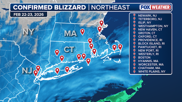
19 official weather reporting sites have observed "blizzard" conditions this morning.
The National Weather Service has officially confirmed that 19 major reporting sites from New York to Massachusetts have met the strict meteorological criteria for a blizzard during this morning's historic bomb cyclone.
On paper, New York City has NOT met the definition of a blizzard. Central Park’s observation site is surrounded by trees, often sheltering it from the wind.
To qualify as an official blizzard, these stations recorded at least three consecutive hours of sustained winds or frequent gusts of 35 mph or greater, accompanied by falling or blowing snow that reduced visibility to a quarter-mile or less.
The verification includes a broad swath of the coastal corridor where the storm’s intense deformation bands have been most persistent.
While many inland locations are experiencing heavy snow, they have yet to officially reach the three-hour duration required for "blizzard" status, though the FOX Forecast Center notes that many are on the verge as high winds continue to lash the region.
The 'generational' blizzard has officially turned the Jersey Shore into a winter wonderland, with Manasquan measuring more than a foot of snow.
Video from the area shows near-zero visibility and heavy, "heart attack" snow piling up rapidly against the backdrop of the Atlantic.
These intense coastal conditions are being driven by a powerful deformation band that is stalling over Monmouth and Ocean counties, where some areas are now bracing for up to 30 inches total.
Central Islip, New York, has officially recorded a massive 27.0 inches of snow as the historic "bomb cyclone" delivers record-breaking accumulation to Suffolk County.
This staggering total aligns with reports from nearby Long Island MacArthur Airport, where nearly 23 inches were measured by 7 a.m. while heavy bands continued to dump snow at rates of 3 inches per hour.
Multiple automated weather observation systems have been knocked offline by the nor'easter.
Fierce winds from the 2026 bomb cyclone have reached such extreme levels that multiple weather reporting sites across Massachusetts have been knocked offline.
With peak gusts exceeding 80 mph on Nantucket and reaching up to 75 mph in coastal areas, these dangerous conditions are not only causing widespread power outages but are also hindering the ability to gather real-time meteorological data at the height of the blizzard.
Governor Matt Meyer says a Level 3 Driving Ban is currently in effect for Sussex and Kent Counties, prohibiting all non-essential travel as the blizzard batters Delaware.
In New Castle County, a Level 2 Driving Restriction is in place, meaning only essential personnel—including emergency workers and healthcare providers—are permitted on the roadways.
The storm’s impact on Delaware’s infrastructure has been severe. The Department of Transportation reports that more than 100 roads in Kent and Sussex Counties are blocked by downed trees and power lines, with many others remaining impassable due to heavy snow accumulation.

More than 76,000 customers are without power in Delaware. (PowerOutage.com)
All public transit services, including DART and university shuttles, are suspended for the remainder of Monday.
State offices across all three counties are closed today as crews work around the clock to restore services.
Tens of thousands of residents remain without power as 45–60 mph winds continue to fell utility poles and trees. Governor Meyer urges all Delawareans to stay home and avoid unnecessary travel while the blizzard warnings remain in effect.
While the current historic blizzard is still battering the region, the FOX Forecast Center is already looking ahead to the next potential winter threat for the Northeast.
Long-range data suggests that both New York City and Boston could see another round of accumulating snow during the Thursday-Friday timeframe.
Some computers forecast models indicate this secondary system has the potential to drop an additional half foot of snow in some areas by Friday evening.
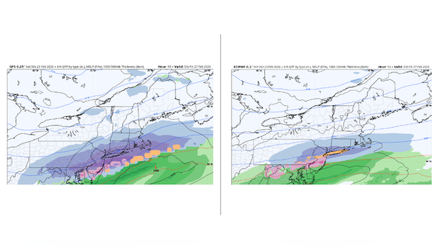
GFS and ECWMWF models show differences in the intensity of the potential late-week snowstorm. (Source: WeatherBELL)
But FOX Weather meteorologists caution that it is currently too early to determine snow amounts with high confidence this far out. Major models are showing significant differences regarding the storm's power; some guidance suggests a direct hit with maximum snow potential, while other models depict a weaker storm that would limit impacts.
Until the current bomb cyclone fully exits the region, these small variations in the expected path will make it difficult to pin down which cities will see the heaviest accumulation from this second late-week system.
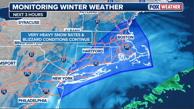
A powerful and dangerous snow band is currently battering Massachusetts and Rhode Island, bringing near-zero visibility and life-threatening whiteout conditions.
The FOX Forecast Center says that this intense band is producing staggering snow rates of 2 to 4 inches per hour.
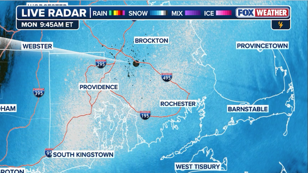
Radar showing a heavy snow band blasting portions of Massachusetts and Rhode Island this morning.
That snow is accompanied by fierce wind gusts ranging from 50 to 75 mph, which are creating massive snow drifts and contributing to widespread power outages.
Officials warn that travel has become nearly impossible as the storm continues its rapid intensification offshore and people are being urged to remain indoors and off the roads until the bands begin to taper off later this evening.
Latest top snow reports from across the Northeast as the blizzard batters millions along the coast.
Quogue, New York, has officially reached a massive 26.0 inches of snow as the historic bomb cyclone continues to punish the south shore of Long Island.
This updated total places the community among the hardest-hit areas in the region, with over two feet of accumulation now complicating emergency response and snow removal efforts.
New York City Emergency Management and NYC Schools have opened three warming centers in the Rockaways to provide relief for residents currently struggling without power during this historic blizzard.
These centers are located at Far Rockaway High School on Bay 25th Street, Beach Channel High School on Beach Channel Drive, and P.S. 43 on Beach 29th Street.
Officials urge residents to use these facilities to stay warm and to check in on neighbors, particularly older adults and those with specific medical needs, while dialing 911 for any life-safety emergencies.
Restoration efforts are now officially underway as PSE&G begins the process of returning customers to grid power across the area. While the city continues to monitor the local grid for any further impacts to critical infrastructure, residents are encouraged to remain indoors while crews work through the extreme conditions.
Providence, Rhode Island, has officially recorded a massive 24.6 inches of snow so far as the historic bomb cyclone delivers its most intense impacts to the Ocean State.
This staggering total places the city at the high end of the forecast and has contributed to a total travel ban as visibility remains near zero across the region.
Nesconset, New York, has officially recorded a staggering 25.6 inches of snow, establishing itself as one of the hardest-hit communities on Long Island during this historic 2026 blizzard.
This significant total follows a period of extreme intensification where snow rates reached 2 to 3 inches per hour, effectively burying the region under nearly two and a half feet of accumulation.
The massive report from Nesconset leads a series of record-breaking totals across Suffolk County, where communities like Shinnecock Hills have also reported over 24 inches.
With local highways in "rough shape" and visibility frequently dropping to near zero, officials are maintaining strict travel bans across Nassau and Suffolk counties while plowing operations struggle to keep pace with the ongoing accumulation.
Shinnecock Hills, New York, has officially reported a massive 24.8 inches of snow, making it one of the highest totals recorded so far during this historic bomb cyclone.
This report places the community at the heart of the storm's most intense snow bands, which have consistently hammered eastern Long Island with several inches of snow per hour.
Authorities continue to warn residents to stay off the roads as wind gusts and heavy drifts make travel impossible throughout the afternoon.
Widespread power outages are impacting hundreds of thousands of people across the Northeast. (PowerOutage.com)
The power crisis across the Northeast is rapidly escalating, with outages officially skyrocketing to over 600,000 customers as the historic blizzard reaches its peak intensity.
Data from PowerOutage.com shows the most dramatic surge occurring within the last few hours as hurricane-force wind gusts of 50 to 75 mph collide with heavy, wet snow.
- Massachusetts: Now leading the region with over 216,000 outages as the storm's core moves toward New England.
- New Jersey: Remains a primary epicenter with 135,000 customers in the dark; in Ocean County alone, more than 13% of the population has lost power.
- Delaware: Nearly 40% of customers for some electric cooperatives have lost service, with statewide totals near 75,000.
- Maryland and Connecticut: Both states are reporting tens of thousands of outages as the regional grid continues to buckle under the strain.
The Blizzard of 2026 has triggered the single largest two-day flight cancellation event of the 2026 travel season, with over 19,000 flights within, into, or out of the U.S. now disrupted.
According to FlightAware, 10,458 of those flights have been canceled outright as a "no-fly zone" effectively descends over the most populated air corridor in the world.
FlightAware MiseryMap showing the significant disruptions throughout the Northeast.
Beyond the major hubs, the FAA has ordered at least 13 regional airports to fully close, including Atlantic City International, Long Island MacArthur, and Wilmington, as crews become unable to keep runways clear against 3-inch-per-hour snow rates.
The chaos is even felt in snow-free zones like Orlando, Atlanta, and Chicago, where thousands of flights are being canceled or delayed due to crews and planes being trapped in the Northeast.
Airlines including Delta, American, United, and JetBlue have issued extensive travel waivers, allowing passengers to rebook through the end of the month as they prepare for what could be a multi-day recovery process.
The City of Brotherly Love has officially surpassed a major milestone in this historic nor'easter, with 13.7 inches of snow now recorded in Philadelphia.
This significant accumulation marks one of the most intense winter events for the city in recent years, contributing to the broader paralysis across the Northeast corridor.
The heavy snow has led to widespread travel disruptions and hazardous conditions, as the storm's powerful winds continue to create massive drifts across the city's streets.
While the 13.7-inch total is already substantial, officials warn that lingering snow bands could add slightly more to the final tally before the system fully pulls away later today.
Metropolitan Transportation Authority Chair and CEO Janno Lieber joined FOX Weather this morning to discuss the agency's massive response as a historic blizzard continues to paralyze the New York City region.
While the city is under its first Blizzard Warning in nine years and a travel ban remains in effect for personal vehicles, Lieber emphasized that the transit system remains operational—albeit with significant safety adjustments.
Exclusive FOX Weather Model showing the snow ending in New York City around 4 p.m. ET.
The FOX Forecast Center is tracking the nor'easter as it blasts millions along the East Coast.
For the millions hunkered down in New York City, the question now is "when will it end?"
FOX Weather meteorologists say the worst of the storm should wind down around noon ET, but light snow may linger through the late afternoon hours.
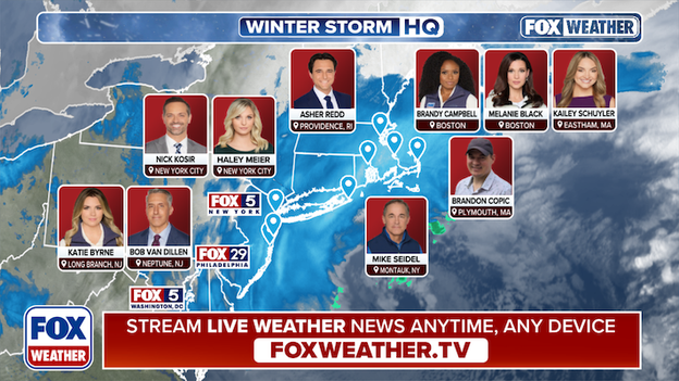
FOX Weather is deploying a team of meteorologists and correspondents across the Northeast ahead of the blizzard.
FOX Weather is providing LIVE, around-the-clock coverage of Blizzard '26. With more than a dozen crews deploying into the storm, this is the place for the most comprehensive storm coverage.
Our team of meteorologists and correspondents will be Weathering It Together with you, reporting on the latest LIVE developments as the storm unfolds.
Latest power outage tracker showing the widespread outages in the Northeast.
New data from PowerOutage.com shows power outages continue to surge along the Northeast coast as the intense blizzard 'bombs out' offshore. More than 525,000 customers are now without power across the region.
FOX Weather meteorologist Bob Van Dillen is LIVE from Manasquan, New Jersey, as a generational nor'easter hammers the Jersey Shore with blinding snow and hurricane-force winds.
The entire state is currently under a Blizzard Warning, marking the first statewide alert of its kind in decades.
The storm, which has rapidly intensified through a process known as bombogenesis, is delivering intense snow rates and has already pushed power outages across the Northeast past 500,000.
Peak wind gusts recorded so far along the East Coast as the blizzard 'bombs out.'
Wellfleet, Massachusetts has officially clocked a hurricane-force wind gust of 77 mph as the historic nor'easter reaches its peak intensity.
This remarkable reading leads a list of extreme wind reports across the region, including a 74 mph gust in Stony Brook, New York, and 73 mph gusts recorded in Kingston, Rhode Island, as well as Norwell and Chatham, Massachusetts.
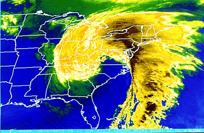
Captured by the GOES-East satellite from its geostationary orbit 22,300 miles above Earth, this simply stunning view reveals the immense scale and classic "comma" shape of the 2026 bomb cyclone.
GOES satellite image showing the powerful nor'easter spinning off the Northeast coast.
The high-definition imagery highlights the storm's incredible intensification, showcasing a distinct eye-like feature as it draws moisture from deep in the Caribbean to bury the Northeast in snow.
Newark, New Jersey, has officially surpassed the 20-inch mark, recording a staggering 21.0 inches of snow as the storm's intense deformation band lingers over the region.
This massive total has effectively paralyzed the city, contributing to the broader state of emergency and the ongoing suspension of transit services across northern New Jersey.
Latest power outage tracker showing widespread outages from Massachusetts to Delaware. (PowerOutage.com)
The historic blizzard battering the Northeast has officially pushed power outages past the half-million mark.
Data from PowerOutage.com indicates that over 500,000 customers are now without electricity as hurricane-force wind gusts and heavy, wet snow continue to dismantle the regional power grid. One customer represents a single address, so the number of Americans without power could be well over 1,000,000 at this time.
The situation remains critical in Massachusetts and New Jersey, which are currently bearing the brunt of the blackouts with combined totals exceeding 270,000 outages. In Delaware, nearly 40% of customers for some electric cooperatives have lost service, while significant disruptions are being reported from Maryland up through Connecticut.
Quogue, New York, has officially joined the ranks of the hardest-hit communities after recording a massive 23.5 inches of snow. This nearly two-foot total underscores the extreme power of the snow bands currently hammering the south shore of Long Island.
The snow totals in Freehold, New Jersey, have officially climbed to a staggering 24.2 inches.
This updated report marks the highest accumulations recorded across the entire Northeast during this historic bomb cyclone.
The town has seen relentless snow throughout the morning, driven by powerful deformation bands that have consistently dumped several inches of snow per hour on central New Jersey.
Latest top snow reports as the nor'easter continues to blast the Northeast.
With over two feet of snow now on the ground, Freehold and the rest of Monmouth County are facing extreme conditions.
Local officials continue to enforce strict travel restrictions as crews struggle to keep up with the massive drifts and near-zero visibility caused by 45 mph wind gusts.
Residents are urged to remain hunkered down as the storm's peak intensity continues to hammer the region.
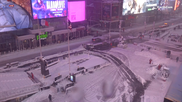
EarthCam camera in Times Square showing empty streets as a citywide travel ban remains in place for New York City.
New York City is currently in the grip of a historic winter event, with Central Park recording 15.1 inches of snow and totals still climbing.
This marks the city's most significant snowstorm since 17.4" fell in February 2021.
The storm, which intensified into a powerful nor'easter, has triggered the city's first Blizzard Warning in nine years.
With snow rates hitting 2 to 3 inches per hour, the impact on the five boroughs has been immediate and severe.
A mandatory citywide travel ban remains in effect to keep non-essential vehicles off the streets, allowing more than 2,300 plows to work through near-whiteout conditions.
Wind gusts have reached as high as 60 mph at JFK International Airport, contributing to widespread visibility issues and making any movement outside life-threatening.
While the heaviest bands are expected to move out by Monday afternoon, officials warn that a "brutal cleanup" lies ahead. Residents are urged to stay indoors and off the roads until the travel ban is lifted. Property owners should also be prepared for their own work; city rules require sidewalks to be cleared within four hours if the snow stops during daylight.
The Federal Aviation Administration (FAA) reports that 13 regional airports across the Northeast have effectively closed as the historic bomb cyclone delivers blinding snow and hurricane-force winds.
These closures come as many facilities become physically unable to keep runways clear against snow rates of 2 to 3 inches per hour and gusts exceeding 70 mph.
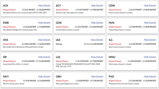
Federal Aviation Administration website shows the closed airports across the Northeast.
While major hubs like JFK, LaGuardia, and Newark are seeing near-total flight cancellations, the shuttering of smaller regional airports underscores the storm's total paralysis of the coastal corridor.
In addition to the frozen runways, the FAA has noted that extreme turbulence and near-zero visibility have made safe takeoffs and landings impossible throughout the morning.
The ongoing nor'easter has transitioned from a standard winter storm into a "textbook" meteorological marvel, undergoing a process known as incredible bombogenesis.
Over the last 24 hours, the storm’s central pressure plummeted by nearly 40 mb, reaching a staggering 972 mb. This rapid intensification has caused the storm to take on hurricane-like characteristics, most notably the development of a defined eye at its center.
This level of intensification is rarely seen outside of scientific literature and represents the sheer power of the bomb cyclone currently paralyzing the Northeast.
As the storm churns off the coast, the formation of the eye serves as a visual testament to the extreme wind speeds and record-low pressure that are fueling the blizzard conditions and widespread power outages across the region.
The MTA is urging New Yorkers to avoid unnecessary travel as the blizzard forces major service cuts across the subway and commuter rail networks. While the city remains under a travel ban for vehicles, the transit system is seeing significant disruptions as crews battle the heavy snow.
- Subway suspensions: The C, Sr, and Staten Island Railway are currently suspended.
- Severe delays: Several major lines, including the 4, 5, B, M, J, L, N, and W, are experiencing severe delays.
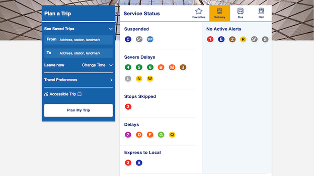
MTA website showing the numerous delays and suspensions due to the nor'easter.
With snow falling at prolific rates, transit officials are reminding riders to check the mta.info service status page or the MYmta app before heading out, as conditions are changing rapidly block-by-block.
The usually bustling streets of the Upper East Side have turned into a silent ghost town as the citywide travel ban keeps all non-essential vehicles off the roads through noon today.
With visibility near zero and Central Park recording more than 15 inches of snow so far, the neighborhood’s residential avenues are now dominated by massive drifts and the quiet hum of the occasional plow.
According to the FOX Forecast Center, New York City and the Lower Hudson Valley are currently getting slammed by the storm's "deformation band"—a classic feature of powerful nor'easters that is dumping exceptionally heavy snow.
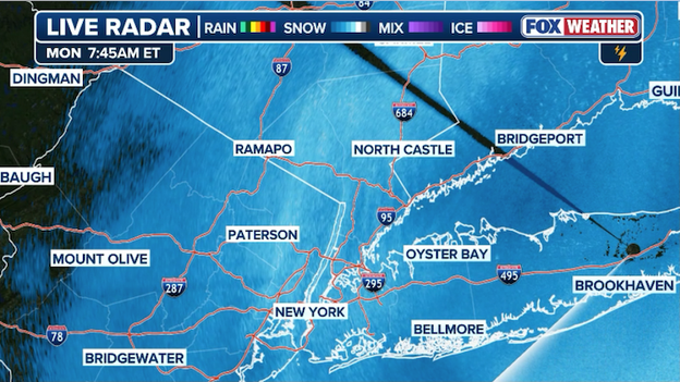
Radar shows the intense deformation snow band stretching from the Hudson Valley to New York City.
This distinct band, clearly visible on radar, is responsible for the intense snow rates and localized whiteout conditions currently occurring across the region.
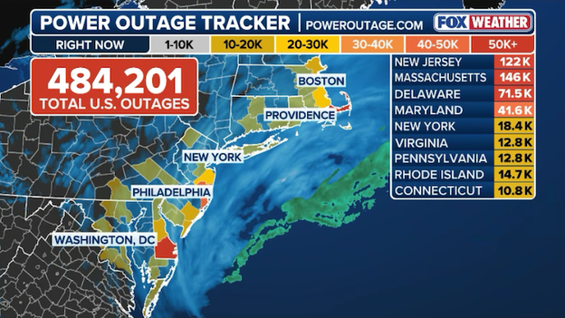
Latest power outage tracker showing thousands of customers without power in the Northeast.
Power outages are surging to critical levels, with 484,201 total U.S. customers now in the dark as the massive blizzard 'bombs' the Northeast.
FOX Weather has seen a significant jump in just the last few hours, as hurricane-force wind gusts—including a peak of 74 mph in Stony Brook, New York—continue to snap utility lines across the region.
According to the latest data from PowerOutage.com, Massachusetts and New Jersey remain the hardest-hit states, with 146,000 and 122,000 outages respectively, while Delaware and Maryland are also seeing major disruptions with tens of thousands of homes without electricity.
Restoration efforts are expected to be slow and dangerous; utility crews cannot safely deploy bucket trucks until these high winds subside, meaning many residents should prepare for a multi-day wait for the lights to come back on.
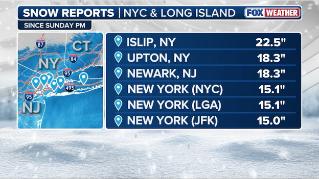
Latest snow reports from around New York City and Long Island (as of 7am ET).
Major reporting sites from New York City and Long Island are now reporting nearly two feet of snow as snow rates 2-3 inches per hour hammer the region.
Newark, New Jersey, has officially recorded 18.3 inches of snow as the historic bomb cyclone delivers one of the most significant winter weather events the city has seen in years.
The FOX Forecast Center says the city is experiencing snow rates of 2 to 3 inches per hour right now.
Central Park has officially recorded 15.1 inches of snow as the historic nor'easter continues to bury Manhattan. This significant total marks one of the city's most substantial snow events in years, contributing to the treacherous conditions that have triggered a citywide travel ban through noon.
As the sun rises over the East Coast, satellite imagery is providing a breathtaking and sobering look at the true scale of the nor’easter currently paralyzing the region. The "eye" of this massive bomb cyclone is clearly visible churning off the coast, with its spiral bands of heavy snow and hurricane-force winds stretching from the Mid-Atlantic all the way into Maine.
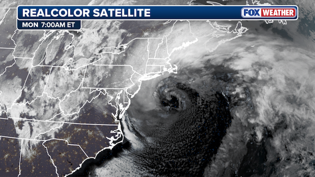
Satellite image showing the immense, intense nor'easter lashing the Northeast U.S.
The satellite view captures the classic "comma" shape of a rapidly intensifying storm, a visual testament to the extreme pressure drop that has fueled this blizzard.
From space, the cloud tops are exceptionally high and cold, indicating the prolific moisture that has already dumped over 20 inches of snow in parts of New Jersey and Long Island. As the storm continues to track northeast, this perspective highlights the immense reach of the wind field that is currently leaving hundreds of thousands of residents without power.
Providence, Rhode Island, is experiencing staggering snow rates as the National Weather Service reports 13.9 inches fell in just a six-hour window this morning. This rapid accumulation has pushed the city's storm total to 16.3 inches so far, with additional heavy bands expected to continue through midday.
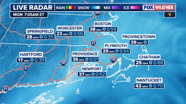
Current radar and wind gusts showing the intensity of the storm over Massachusetts.
The historic Blizzard of 2026 is reaching its peak intensity off the coast of New England, with hurricane-force wind gusts and extreme snow rates paralyzing much of Massachusetts.
The FOX Forecast Center has confirmed that hurricane-force gusts are occurring and are likely to continue into the afternoon as the storm's central pressure drops even further.
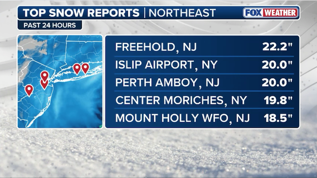
Latest top snow reports from FOX Weather.
The town of Freehold, New Jersey, has officially shattered the 20-inch mark, recording a massive 22.2 inches of snow as of Monday morning.
This updated total places Freehold among the highest recorded accumulations in the region, surpassing many early projections and highlighting the sheer power of the stationary snow bands that have hammered central New Jersey.
As the bomb cyclone continues to churn offshore, residents in Monmouth County are facing extreme whiteout conditions and massive drifts, making any attempt at travel life-threatening.
With Blizzard Warnings still in effect, officials are urging everyone to stay hunkered down as crews struggle to keep pace with these historic snow rates.
Hurricane-force winds have now been recorded as the blizzard blasts the Northeast.
The bomb cyclone has officially delivered hurricane-force wind gusts to Long Island, with Stony Brook, New York, recording a top gust of 74 mph this morning. This major reading places Stony Brook among the hardest-hit areas in the region as the storm continues to intensify offshore.
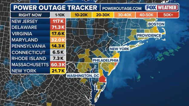
Latest power outage tracker showing more than 400,000 customers without power in the Northeast.
More than 400,000 customers are now without power across the Northeast.
Data from PowerOutage.com indicates that as the storm's core moves through the region, the combination of near-hurricane-force wind gusts and heavy, wet snow is overwhelming the grid.
Restoring power will likely be a slow, multi-day process. Utility officials in Connecticut have warned that full restoration could take anywhere from four to six days. High winds are currently preventing crews from using bucket trucks for safety reasons, meaning repairs in many areas cannot begin in earnest until the storm subsides on Tuesday.

Latest top snow reports from the monster blizzard blasting the Northeast.
The town of Islip, New York, has officially recorded a massive 20.0 inches of snow as the historic bomb cyclone continues its relentless assault on the region.
This milestone represents one of the highest totals reported on Long Island so far, as intense bands of snow have been dumping accumulation at rates of 2 to 3 inches per hour throughout the morning.
The 20-inch report in Islip aligns with broader forecasts that predicted up to two feet of snow for the area. Residents across Suffolk County are facing extreme whiteout conditions and life-threatening travel, with all non-essential driving currently prohibited under a local travel ban.
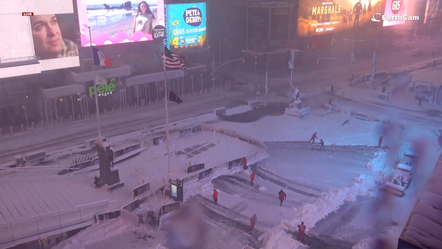
EarthCam camera showing a snow-covered Times Square in Midtown Manhattan.
An EarthCam view of Times Square this morning reveals a rare sight: one of the world's busiest intersections is virtually a ghost town. Under the mandatory citywide travel ban, the neon-lit streets are completely empty of cars and tourists, leaving only a dedicated team of emergency snow shovelers visible as they work tirelessly to clear the mounting accumulation.
Latest power outage tracker showing widespread outages throughout the Northeast.
The bomb cyclone slamming the East Coast has officially knocked out power to nearly 300,000 customers across the Northeast.
Data from PowerOutage.us indicates that as of 6:00 a.m. ET, the bulk of these outages are concentrated in New Jersey and Delaware, where a combination of heavy snow load and fierce winds is snapping tree limbs and utility lines.
- New Jersey: Remains the epicenter of the crisis with over 115,000 customers in the dark. In Ocean County alone, more than 13% of the population has lost power as 70 mph gusts lash the coast.
- Delaware: Outages have climbed to nearly 72,000, with the Delaware Electric Coop reporting that almost 42% of its customer base is currently without electricity.
- Massachusetts: Outages are skyrocketing as the blizzard blasts the state. More than 60,000 customers are now in the dark.
NJ Transit website showing the systemwide service suspension as of 5:45 a.m. ET Monday.
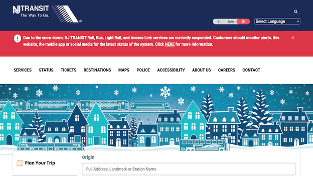
All NJ Transit services remain under a full systemwide suspension this morning as the historic bomb cyclone continues to batter the state with extreme snow and high winds. This total shutdown includes all bus, rail, light rail, and Access Link operations.
While some service began tapering off early Sunday evening, the final rail trips concluded by 9:00 p.m. to ensure the safety of both passengers and employees during the peak of the storm.
NJ Transit officials and the Emergency Operations Center are currently monitoring weather conditions and assessing the storm's impact on tracks, overhead wires, and roads.
- Ongoing assessment: Officials will continue to evaluate the system throughout the morning to determine when it is safe to begin a gradual resumption of service.
- Snow-fighting operations: Even while service is suspended, you may see empty trains or light rail vehicles moving; these are being operated specifically to keep tracks and overhead wires clear of heavy snow and ice buildup.
- Travel advice: Governor Sherrill has urged residents to stay off the roads, which must remain clear for local and state snow removal crews to work efficiently.
Lewes, Delaware, has reported a significant 18.0 inches of snow as the historic blizzard continues to lash the coast with near-whiteout conditions. This total reaches the high end of local forecasts, with heavy snow bands still expected to drop additional accumulation through the morning hours.
Freehold, New Jersey, has just reported a massive 19.0 inches of snow as the heart of the bomb cyclone delivers some of its highest totals yet.
This major measurement highlights the extreme accumulation occurring across central New Jersey, where intense snow bands have been stationary for several hours.
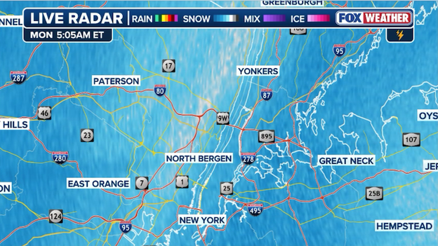
Radar analysis shows heavy snow and blizzard conditions from Massachusetts to New York this morning.
If you thought it couldn't get more intense, the storm is proving us wrong. Forecasters are seeing widespread snow rates of 2 to 3 inches per hour that are expected to hammer Long Island and Southern New England through at least 10:00 a.m. ET.
While the snow was previously hitting in scattered bands, the storm is now consolidating into one massive primary band that stretches from Long Island all the way to Eastern Massachusetts.
This is the absolute peak of the event—driven by an impressive surge of moisture (what meteorologists call the warm conveyor) colliding with the freezing core of the storm.
New York City remains at a standstill this morning as a mandatory citywide travel ban continues to hold all non-essential vehicles off the streets.
Mayor Zohran Mamdani's emergency order, which began at 9:00 p.m. Sunday, is designed to keep roads clear for emergency responders and the city's massive fleet of 2,300 snowplows as they battle the most significant blizzard to hit the five boroughs since 2017.
- Duration: The ban is strictly in effect until 12:00 p.m. today.
- Scope: All city streets, highways, bridges, and tunnels are closed to non-emergency vehicular traffic.
- Who can drive: Only essential workers (medical personnel, first responders, utility crews) and those traveling for a documented emergency are permitted on the roads.
- Penalties: Vehicles found on the roads in violation of the ban are subject to fines and immediate towing to ensure they do not block plowing operations.
- Public Transit: While the travel ban applies to cars, scooters, and e-bikes, most subway lines continue to operate—though many have switched from express to local service.
The bomb cyclone currently offshore is unleashing ferocious winds across the Northeast, with several coastal communities reporting gusts reaching or exceeding 70 mph. These powerful gales are the primary driver behind the widespread whiteout conditions and surging power outages currently paralyzing the region.
Data from the FOX Forecast Center highlights the extreme intensity of the wind field as the storm's pressure continues to bottom out:
- Bellefonte, DE: Leading the region with a staggering 72 mph gust—just shy of the official hurricane-strength threshold (>74 mph).
- Keyport, NJ: Recording a peak gust of 67 mph.
- Barnegat Inlet, NJ: Seeing consistent lashing with gusts up to 66 mph.
- Stony Brook, NY: Clocking in at 63 mph as the storm core moves past Long Island.
- Atlantic City, NJ: Recording 60 mph gusts alongside heavy coastal flooding and snow.
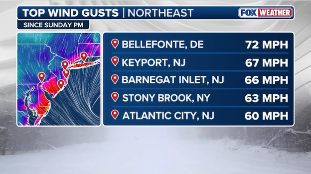
Peak wind gusts from the nor'easter have topped 70 mph in some places along the East Coast.
These winds are expected to remain intense for several more hours, making travel dangerous and posing a severe threat to standing trees and power lines. Residents are urged to stay away from windows and remain indoors until winds subside later today.
As the nor'easter hammers New York City with snow rates reaching up to 2 to 3 inches per hour, the Department of Sanitation (DSNY) has moved into a full-force, around-the-clock operation. To keep up with the rapidly accumulating snow, the city has deployed more than 2,600 sanitation workers on successive 12-hour shifts.
The scale of the deployment is historic, matching the intensity of the first Blizzard Warning issued for the city in nine years:
- Plows and spreading: Over 2,300 plows are currently active across the five boroughs, accompanied by a fleet of 700 salt spreaders.
- New technology: For this storm, DSNY is utilizing expanded geocoded tracking to more efficiently clear critical pedestrian infrastructure, including bus stops, crosswalks, and fire hydrants.
- Real-time tracking: Residents can monitor the progress of these crews block-by-block through the city's PlowNYC portal.
- Emergency support: The city has also activated over 1,000 emergency snow shovelers—a significantly earlier and larger deployment than in previous storms—to assist in clearing key public areas.
While the city’s travel ban remains in effect until noon today to allow "New York's Strongest" to work safely, officials are reminding property owners of their responsibilities. Once the snow stops, a path of at least 4 feet must be cleared on all sidewalks to accommodate wheelchairs and strollers. Additionally, due to the all-hands-on-deck snow response, trash and recycling collection will be delayed by at least one day.
Radar showing the intense mesoscale band of heavy snow hammering parts of New Jersey.
A powerful mesoscale snow band is currently locked in over Jersey City, Hoboken, and Newark, delivering some of the most intense snow rates seen yet during this bomb cyclone. While much of the region is seeing steady snow, this specific band is producing localized rates of 1 to 2 inches per hour, causing visibility to drop to near zero across Hudson and Essex counties.
The impact of this relentless hammering is already reflected in the numbers, with Newark reporting a staggering 11.1 inches as of 5:00 a.m.. Residents just west of the Hudson River should prepare for conditions to remain life-threatening through the morning, as these stationary bands can easily bury neighborhoods under an additional half-foot of snow in just a few hours.
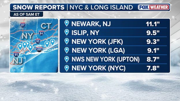
Latest snow reports from the New York City metro area show the city is closing in on the one foot mark.
The early morning snow reports are in, and they confirm that the New York City metro area is rapidly approaching the one-foot mark.
Newark, NJ has already crossed that threshold with 11.1 inches on the ground, while Islip and JFK are following closely behind at 9.5 inches and 9.3 inches respectively.
Even Central Park (NYC) has officially recorded 7.8 inches, with totals expected to climb as the storm's core moves through.
Current radar analysis from the FOX Forecast Center shows 1 to 2-inch-per-hour snow rates are ongoing across the region.
These intense bands are creating a high risk for full blizzard conditions over the next few hours, particularly for coastal areas and the immediate NYC metro, as the "bomb cyclone" continues to intensify.
FlightAware MiseryMap showing the total flight disruptions throughout the Northeast today.
The historic "bomb cyclone" has officially triggered a national travel nightmare, with flight disruptions now surpassing the 18,000 mark through Tuesday.
According to the latest data from FlightAware, the storm has forced the cancellation of more than 10,000 flights, while an additional 8,000 have faced significant delays as the blizzard paralyzes the Northeast corridor.
The grounding is most severe at the primary entry points to the region, where airlines have preemptively cleared their schedules to avoid stranding aircraft in the path of the storm. Most of the flights at LaGuardia, JFK, Newark, and Boston have been canceled for today.
Power outages continue to skyrocket throughout the Northeast as the blizzard 'bombs out' offshore. (PowerOutage.com)
The historic blizzard is currently overwhelming the power grid, with regional outages officially surpassing the 250,000 mark as of Monday morning. The combination of 70 mph wind gusts and heavy, wet snow is snapping utility lines and downing trees across the I-95 corridor.
- New Jersey: Remains the hardest-hit state with over 100,000 customers in the dark. Ocean County is facing the most severe impact, with more than 11% of the county currently without power.
- Delaware: Outages have climbed to nearly 68,000, with the Delaware Electric Coop reporting nearly 40% of its customers affected.
- Virginia and Maryland: Both states are seeing roughly 25,000 outages each as the storm's core moves through the Mid-Atlantic.
- Connecticut: Governor Ned Lamont has warned that "several hundred thousand" residents could eventually lose power, with restorations potentially taking four to six days due to the severity of the damage.
Because travel is currently dangerous and travel bans are in place across parts of the region, repair crews are facing significant delays in reaching downed lines until the wind and snow subside later today.
Don't miss out: you can go back and see LIVE updates from Sunday's coverage of this historic blizzard.
Click here to see the minute-by-minute updates from FOX Weather.
You’ve reached the beginning of this live coverage.