Live updates: Historic blizzard targets millions in the Northeast with blinding snow, intense winds
Live updates: Historic blizzard targets millions in the Northeast with blinding snow, intense winds
Download the AppLIVE Blizzard '26 coverage continues
View postCoverage for this event has ended.
FOX Weather is your Winter Storm HQ, providing around-the-clock live coverage to help keep your family safe.
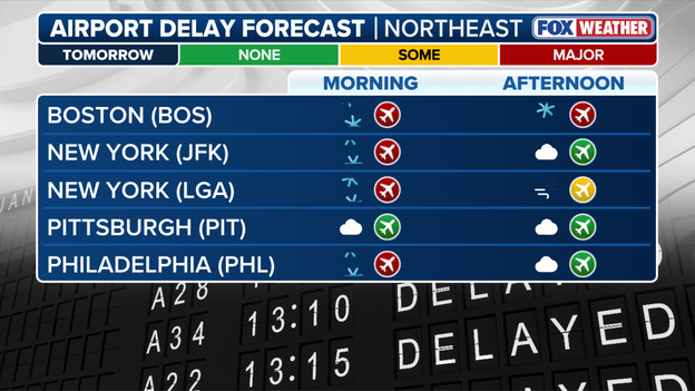
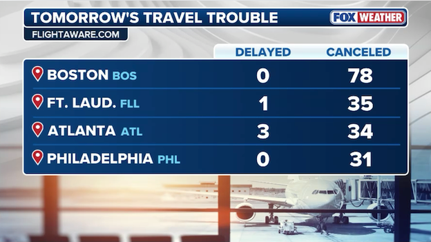
Airport delay forecast in the Northeast
As of 6am ET, 6,456 U.S. flights have been canceled due to the incoming storm, with an additional 547 flights delayed so far through Tuesday.
That brings the total number of disrupted U.S. flight to more than 7,000.
According to data from FOX Weather's exclusive partner FlightAware, the most impacted airports include:
- JFK
- Laguardia (LGA)
- Newark Liberty (EWR)
- Philadelphia (PHL)
- Reagan National (DCA)
- Boston Logan (BOS)
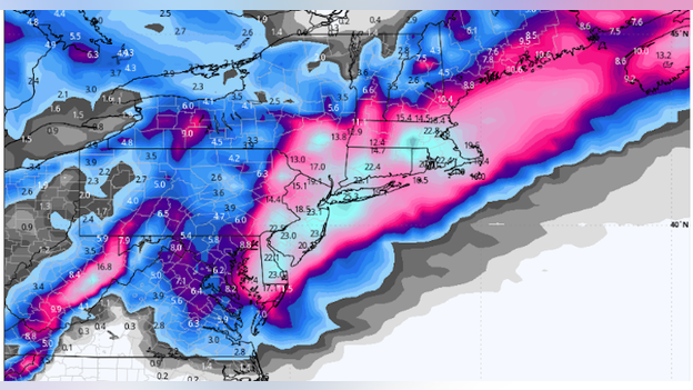
Snow totals are little changed overnight, according to the FOX Forecast Center.
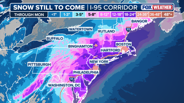
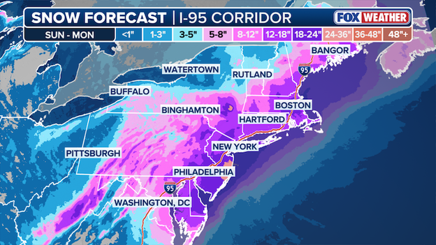
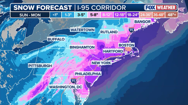
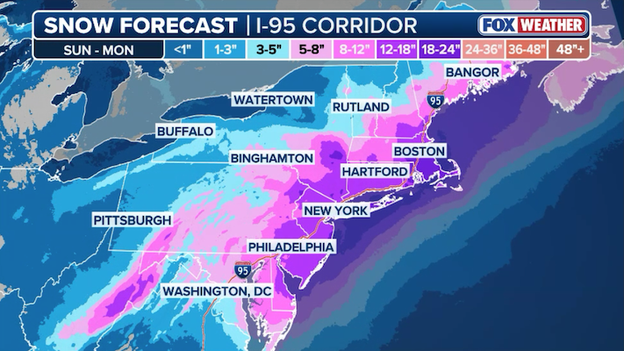
Snow forecast in the Northeast through Monday
New York City, Boston and Philadelphia are all projected to receive between 18 and 24 inches of snow.
The nation's capital is still expected to see 5-8 inches, along with nearby Baltimore, whose projections have come down overnight.
The Jersey Shore is still projected to see more than 2 feet of snow beginning Sunday, as this historic nor'easter slams the region.
FOX FORECAST CENTER SNOW TOTALS
- Boston: 18-24"
- NYC: 18-24"
- Jersey Shore: 2ft+
- Philadelphia: 18-24"
- Baltimore: 5-8"
- Washington, D.C.: 5-8"
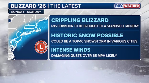
FOX Weather's latest report on the nor'easter
On the cusp of the Blizzard of '26, stay with FOX Weather as history unfolds in the form of a bombing nor'easter.
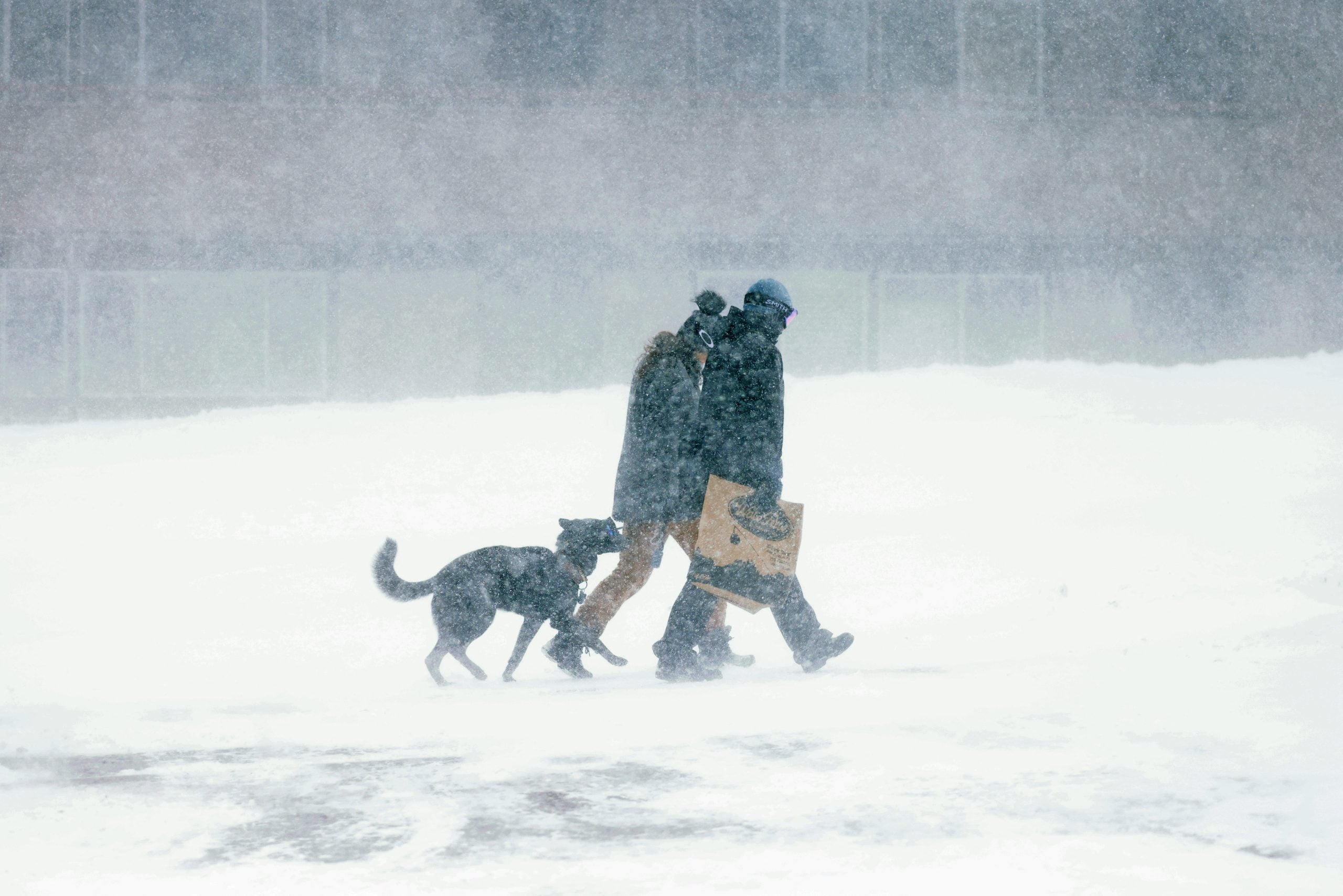
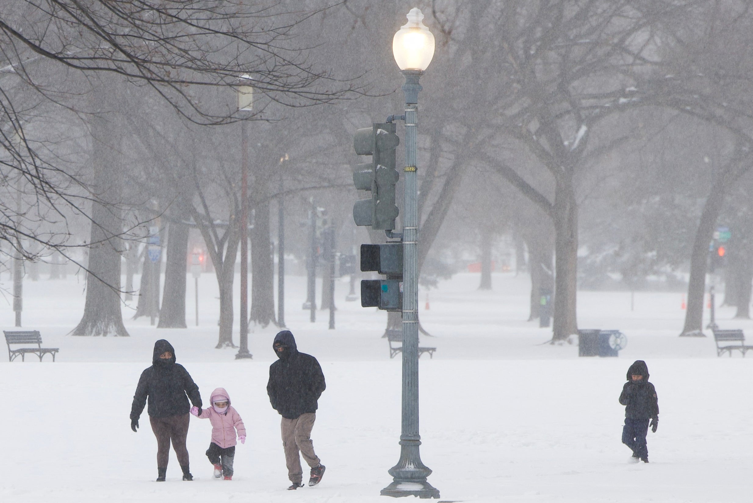
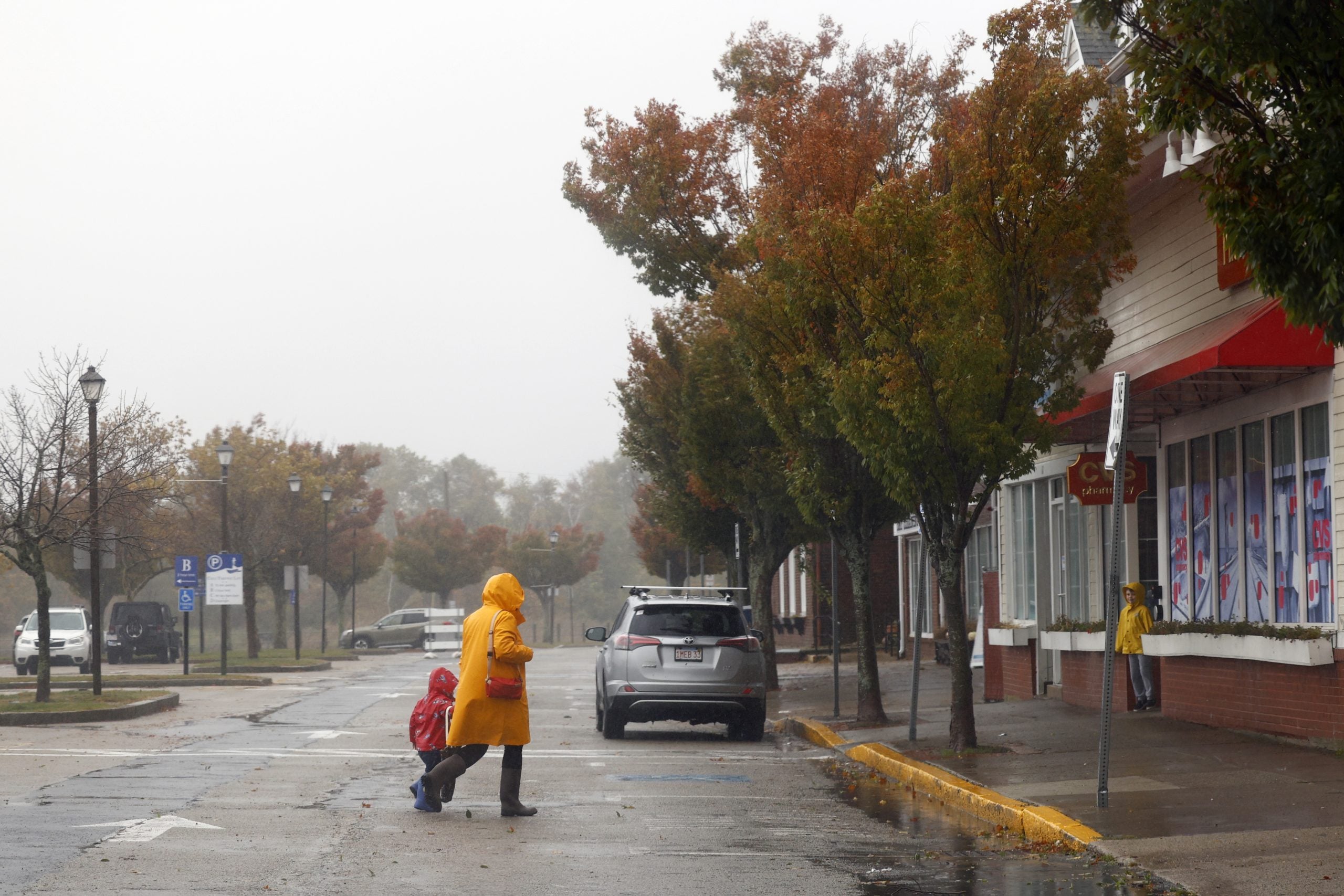
A crippling blizzard, historic snow and intense winds are all on the table as millions along the Northeastern Seaboard brace for what will be an unforgettable storm.
Over 600 miles of coastline is in the cross-hairs for significant coast impacts. Over 29 million Americans are currently under Blizzard Warnings, the top tier Winter Alert. Thousands of flights have already been cancelled and all methods of travel will likely be crippled across affected areas into Monday.
From first flakes to full impact, FOX Weather is delivering live, around-the-clock coverage across the Northeast as the historic storm happens.
Stay with FOX Weather all weekend long as we track this monster storm threatening millions of Americans.
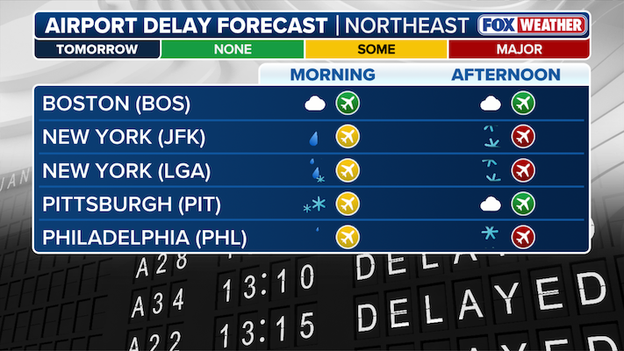
Airport delay forecast in the Northeast
Major airports in the Northeast have begun preemptively canceling flights ahead of the arrival of an impactful nor'easter forecast to slam the region.
According to data from FOX Weather’s exclusive partner FlightAware, over 3,000 flights have been canceled across the Northeast's major travel hubs so far.
Cancellations and delays are expected to continue to mount as we inch closer to the crippling impacts the nor'easter will have on all forms of travel across the region.
The FOX Forecast Center's evening update has bumped up snow totals in both New York City and Philadelphia.
Snow forecast in the Northeast through Monday
Both the Big Apple and the City of Brotherly Love are forecast to see 18+ inches of snow, as we inch closer to the historic nor'easter.
The FOX Forecast Center is specifically forecasting 2 feet of snow along the Jersey Shore. There are expectations that an intense band of snow will set up in the region and dump rates of 2-4 inches per hour.
FOX FORECAST CENTER SNOW TOTALS
- Boston 18-24"
- New York City 18-24"
- Jersey Shore 2ft+
- Philadelphia 18-24"
- Baltimore 8-12"
- Washington 5-18"
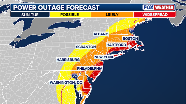
FOX Forecast Center's Power Outage Forecast
Widespread power outages are now expected along select areas of the East Coast, from Delaware, through the Jersey Shore and up to Boston.
The FOX Forecast Center now expects widespread power outages due to increased confidence of prolonged dangerous 55 to 70 mph wind gusts and heavy, wet snow that will put significant strain on utilities across coastal areas in the Northeast.
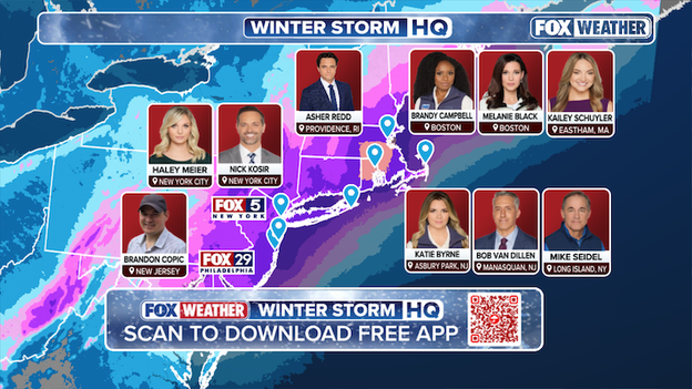
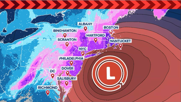
FOX Weather Nor'easter Live Coverage Map
We are just hours away from a potentially historic nor’easter set to slam the Northeast. Feet of snow, dangerous winds and major travel disruptions are expected as millions across the region prepare for the storm.
FOX Weather is where the storm hits, when it arrives. An experienced group of FOX Weather meteorologists and field correspondents will be on the front lines of the storm, delivering live updates to keep you informed and out of harm’s way.
As the storm unfolds, stay with FOX Weather for live coverage, in-depth analysis and the latest updates.
Airlines are now canceling hundreds of flights ahead of the historic blizzard.
As the Northeast prepares for a historic blizzard, major airlines are proactively canceling thousands of flights to prevent aircraft and crews from being stranded in the storm's path.
According to FlightAware , carriers including Delta, American, and United have already begun processing cancellations at critical hubs like JFK, LaGuardia, Newark, and Boston Logan to ensure operational safety as heavy snow and 50 mph winds approach.
JetBlue, which operates major hubs across the Northeast, has begun preemptively canceling flights ahead of the Nor'easter. An analysis of data from FOX Weather’s exclusive partner FlightAware shows that 40% of the airline’s schedule has been canceled for tomorrow, with another 24% already canceled for Monday.
More than 2,200 U.S. flights have already been canceled through Monday. That number is expected to continue to surge in the next 24 hours as the storm ramps up.
In addition to domestic disruptions, international carriers have also canceled select flights to New York for Sunday and Monday, citing the high risk of near-blizzard conditions.
Travelers are strongly urged to use airline mobile apps to monitor their flight status, as these early cancellations are likely just the beginning of a massive disruption expected to ripple across the national aviation network through midweek.
A dangerous nor'easter bomb cyclone is forecast to blast millions along I-95 with heavy snow and intense winds.
- Blizzard Warnings issued: The National Weather Service has issued Blizzard Warnings for nearly 30 million Americans from Boston to New York City to Atlantic City to Delaware and Maryland.
- "Monster" snow totals: Forecast confidence is surging for a historic event. Some models are now painting more than two feet of snow for parts of New Jersey, while the broader I-95 corridor from Philly to Boston is bracing for 12–24 inches.
- Whiteout conditions: Once the storm "bombs out" on Sunday, 50-60 mph wind gusts will combine with snow rates of 1–3 inches per hour to create total whiteout conditions.
- Coastal crisis: Along with the snow, coastal flooding and significant beach erosion are expected. A Storm Warning is in effect for coastal waters, with breaking surf threatening shoreline structures.
- Power outage risk: Due to the heavy, wet nature of the initial snow and the extreme wind gusts, widespread and prolonged power outages are considered a high probability for the I-95 corridor.
- Travel nightmare: Airlines have already canceled hundreds of flights through Monday with blizzard conditions expected to bring Northeast air travel to a halt.
FOX Weather is often asked "do winter storms get names?" The answer is no.
The National Weather Service (NWS) and the National Oceanic and Atmospheric Administration (NOAA) do not recognize or use names given to winter storms by media outlets or private organizations in official forecasts.
The National Weather Service issues detailed forecasts and alerts to communicate specific impacts from winter storms, but we do not name them.
Unlike hurricanes, which are well-defined systems with a single clear center, winter storms are often broad, unorganized, and can have multiple centers that shift or redevelop. A single winter system can produce vastly different conditions across a region—such as a blizzard in one area and just rain in another—making a single name potentially misleading to the public.
The names you may have seen were developed without collaboration or consultation with official global weather authorities like the World Meteorological Organization (WMO) or the American Meteorological Society (AMS).
Official agencies argue that naming winter storms is driven more by social media needs, such as creating hashtags, and marketing rather than sound meteorological science. The NWS has advised its forecast offices to avoid these names because they can create confusion, as the names are not used on official government warnings or safety bulletins.
In a statement to FOX Weather, the National Weather Service said, "The NWS will name tropical systems, but does not do this unilaterally - these names are from a list established by an international committee of the U.N. World Meteorological Organization.
Spokesperson Marissa Anderson told us, "This naming is contingent upon well defined and universal criteria (eg: an organized area of low pressure with top winds of at least 39 mph). Names are given to these systems because they are discrete and naming provides a common link as these storms traverse international boundaries and multiple languages, and to distinguish between multiple storms that may threaten a region concurrently. Unlike tropical systems, winter storms are more diverse with impacts that evolve throughout the storm’s life."
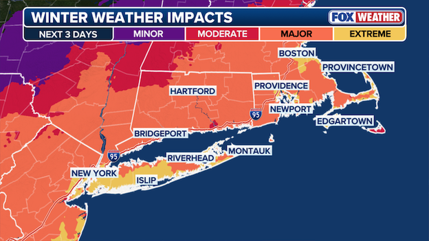
Winter Storm Impact Map
Extreme Impact Zones have been expanded to include New York City and Boston.
In an extreme impact zone, substantial disruptions to daily life are expected. Travel is not advised in these areas due to extremely dangerous if not impossible driving conditions.
Expect extensive and widespread closures, and disruptions to infrastructure may occur.
FOX Forecast Center is tracking a potentially historic nor'easter
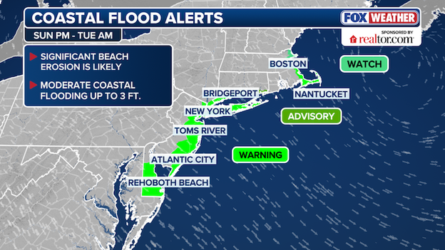
New York City is now under coastal flood warning, as coastal flood watches have been elevated to coastal flood warnings from Delaware to Maine beginning Sunday night and lasting until Tuesday.
Significant beach erosion and moderate coastal flooding are likely as a powerful nor’easter will lash the East Coast with dangerous storm swells.
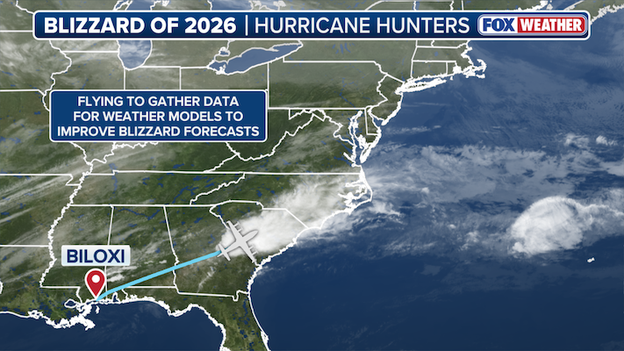
Hurricane Hunters flight tracker
The 53rd Weather Reconnaissance Squadron 71 departed from Keesler Air Force Base in Biloxi, Mississippi to sample the environment ahead of the formation of a potentially historic nor'easter forecast to slam the Northeast Sunday.
The data collected is used to inform weather models to improve blizzard forecast as millions brace for a weekend of harsh winter weather in the Northeast.
Track their flight here.
NJ Transit is taking aggressive measures to ensure resident safety as the historic bomb cyclone approaches, officially announcing systemwide cross-honoring for all rail, bus, and light rail services.
This allows passengers to use their tickets or passes on alternate travel modes to reach their destinations as safely and quickly as possible.
While service is being maintained as long as safely possible, officials are deeply concerned about travel conditions on major arteries like the New Jersey Turnpike and Garden State Parkway, where speed limits have already been dropped in anticipation of the storm.
NJ Transit leadership and Governor Sherrill are strongly urging all New Jerseyans to stay off the roads to prevent accidents and allow emergency crews the "time and space" needed to clear heavy accumulation.
Governor Mikie Sherrill has officially declared a State of Emergency for all 21 New Jersey counties in anticipation of the severe winter storm poised to bury the state.
With snow accumulations now estimated to reach at least 12 inches statewide, the Governor’s executive order aims to ensure that emergency resources are fully deployed to combat heavy snow, freezing temperatures, and dangerous wind gusts.
In her second major weather test since taking office, Governor Sherrill urged all New Jerseyans to stay off the roads and remain home as conditions deteriorate rapidly early Sunday.
As New York City enters a high-alert phase for a massive blizzard, Mayor Zohran Mamdani has mobilized an extensive emergency warming network to protect vulnerable residents.
To ensure no one is left in the life-threatening elements, the city has deployed a fleet of over 18 warming buses stationed near major hospitals, subway hubs, and drop-in centers.
Additionally, 13 schools across all five boroughs have been converted into emergency warming centers, while 11 NYC Health + Hospitals facilities are operating as 24/7 warming hubs.
Officials are urging New Yorkers to call 311 to locate the nearest facility and to check on neighbors as the storm hits.
Mayor Zohran Mamdani announced that a final determination on the status of NYC Public Schools for Monday will be communicated to families by noon on Sunday.
During a weather briefing, the Mayor said the delay in making a final call is largely due to the evolving nature of the forecast.
Rather than canceling classes altogether, the city may move to remote learning for Monday due to the extreme winter weather conditions.
The MTA is moving into emergency positioning as a historic blizzard prepares to slam New York City’s transit network.
With over 220 miles of outdoor track vulnerable to heavy snow and 50 mph gusts, the agency is deploying its full arsenal of snow-clearing trains and de-icing equipment to keep the system moving.
Commuters should prepare for a difficult Monday, as express trains will likely be moved to local tracks to store trains in the tunnels and to allow for continuous snow removal.
While crews will be working around the clock to monitor and clear tracks, significant delays and service modifications are expected across the subways, LIRR, and Metro-North.
Governor Mikie Sherrill will hold a special press conference at 2:00 p.m. ET today as the state prepares for the impending historic blizzard.
New York City has entered full mobilization mode as the Department of Sanitation (DSNY) transitions to 12-hour shifts to provide round-the-clock snow-fighting coverage.
Mayor Zohran Mamdani says over 2,000 sanitation workers are being deployed on these rotating schedules to man the city's frontline defense, which includes 700 salt spreaders and over 2,000 plow-equipped trucks.
To stay ahead of the "bomb cyclone," DOT and DSNY crews are now pretreating roads, highways, and bike lanes with liquid brine to prevent snow from bonding to the pavement.
With a Blizzard Warning now in effect, these proactive measures are critical as the city braces for snow rates that could exceed 2 inches per hour during the height of the storm.
On Tuesday, Governor Kathy Hochul declared a State Disaster Emergency for the entire state of New York as a relentless series of winter storms threatened public safety and critical infrastructure.
The ongoing cycle of heavy snow, high winds, and dangerously low temperatures since late January has significantly depleted the state’s supply of road salt and other vital resources.
This executive order allows for more efficient coordination of emergency personnel and streamlines the procurement of essential supplies to ensure that state and local governments can continue responding to hazardous roadway conditions and potential power outages.
New Yorkers are urged to limit travel and follow all local safety protocols as crews work around the clock to gear up for Sunday's impending blizzard.
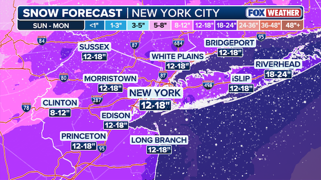
The FOX Forecast Center says new model data suggests some major cities will see even more snow than expected.
- New York City: 12-18"
- Long Island: 18-24"
- Jersey Shore: 18-24"
- Boston: 18-24"
- Long Island: 12-18"
- Philadelphia: 12-18"
- Baltimore: 8-12"
- Washington: 5-8"
Latest snow forecast from FOX Weather showing 1-2 feet of snow along I-95 in the Northeast.
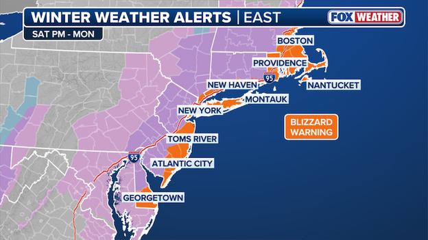
Winter Weather Alerts
Boston is the most recent city to fall under a Blizzard Warning as the East Coast prepares to face-off against a major nor'easter packing high winds and dumping heavy snow across the region.
Blizzard Warnings now stretch from the Delaware coast to the Jersey Shore, into New York City, across Long Island and through Boston.
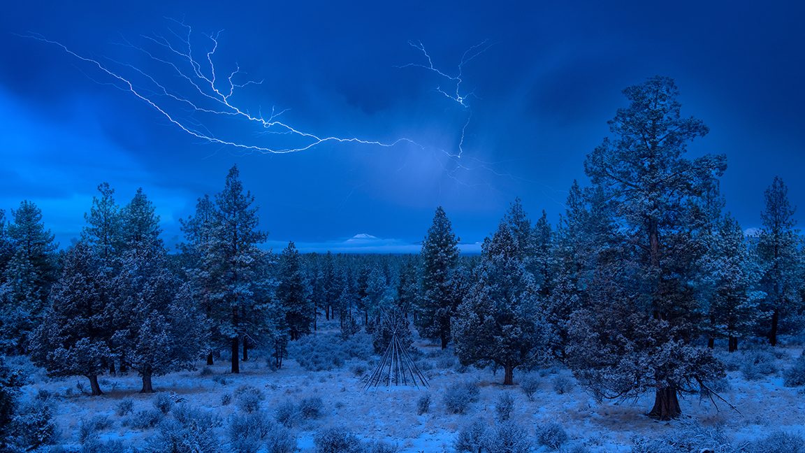
While standard blizzards are dramatic enough, this weekend’s bomb cyclone brings the rare and electrifying possibility of thundersnow.
Often described as a winter thunderstorm, thundersnow occurs when the primary precipitation is snow instead of rain. It is a rare phenomenon because cold, dense winter air is typically too stable to rise and create lightning; however, when a storm bombs out with extreme intensity, it can create the powerful upward motion—or convection—necessary to generate a charge.
Because snow muffles sound, you often won’t hear the thunder until you are within a few miles of the lightning strike, making the experience both eerie and awe-inspiring.
Who could see it this weekend?
FOX Weather forecasters are watching the most intense mesoscale snow bands for thundersnow potential. These are the areas where snow rates could hit 2 to 3 inches per hour.
- The I-95 corridor: Residents in New York City, Philadelphia, and Boston could have a front-row seat as the storm reaches maximum intensity Sunday night into Monday morning.
- Coastal New Jersey & Long Island: As the center of the bomb cyclone passes just offshore, the atmospheric instability will be highest here, potentially triggering flashes of blue lightning amidst the whiteout.
- New England coast: Areas from Providence up to Portland could see thundersnow as the system pushes northeast through Monday afternoon.
While the official forecast for major cities like New York City and Philadelphia currently sits in the 12-to-18-inch range, FOX Forecast Center meteorologists are keeping a close eye on "jackpot" potential where totals could soar much higher.
The key to hitting elusive 24"+ snow totals lies in the development of narrow mesoscale snow bands—intense ribbons of moisture that can drop 2 to 3 inches of snow per hour for several consecutive hours.
If the storm bombs out with maximum intensity and stalls slightly offshore in the perfect spot, these bands could remain stationary over lucky (or unlucky) areas in South Jersey, Long Island, or eastern New England, potentially pushing localized totals toward 30 inches or more.
Latest Global Forecast System (GFS) model showing where more than 2 feet of snow could fall through Monday. (Source: WeatherBELL)
Current models are already showing monster potential, with some high-resolution simulations painting a jackpot zone of more than two feet in southern New Jersey.
History tells us that in generational events like this, there is often one "jackpot spot" that exceeds the surrounding totals by a significant margin due to "dynamic cooling" and extreme moisture intake from the Atlantic.
While 3-foot totals are unlikely, the combination of record-breaking snow rates and high wind gusts could easily lead to drifts exceeding 5 to 6 feet, creating a buried effect for communities in the storm’s direct path.
As a major blizzard prepares to paralyze the Eastern Seaboard, Amtrak has officially announced service adjustments for Sunday and Monday.
Citing an "abundance of caution" after consultations with meteorologists and local officials, the rail service is proactively modifying routes to ensure the safety of passengers and crew during the peak of the blizzard.
Impacted travelers will be notified directly of cancellations, and Amtrak is currently offering a "no-penalty" policy for customers who need to rebook or request refunds via their website, mobile app, or at 1-800-USA-RAIL.
These adjustments are part of a broader regional effort to limit travel during life-threatening conditions, as heavy snow and 50+ mph winds are expected to make outdoor movement nearly impossible.
Travelers are strongly encouraged to monitor @AmtrakNECAlerts for real-time updates on the Northeast Corridor—including Acela and Northeast Regional services—and to subscribe to automated delay alerts at Amtrak.com/DelayAlerts.
As the storm intensifies, further changes may be warranted, so checking train status via the Amtrak mobile app before heading to the station is highly recommended.
Predicting the outcome of a major nor'easter or blizzard is often described as one of the most high-stakes impossible tasks in meteorology.
Unlike many other weather events, these coastal monsters thrive on a volatile "diesel engine" of clashing air masses—dry, bitter cold from Canada meeting warm, moisture-rich air from the Gulf Stream.
Because this temperature gradient is so sharp, a storm’s track wobbling by just 30 to 50 miles can be the difference between a city being buried in two feet of monster snow or simply waking up to a cold, dreary rain.
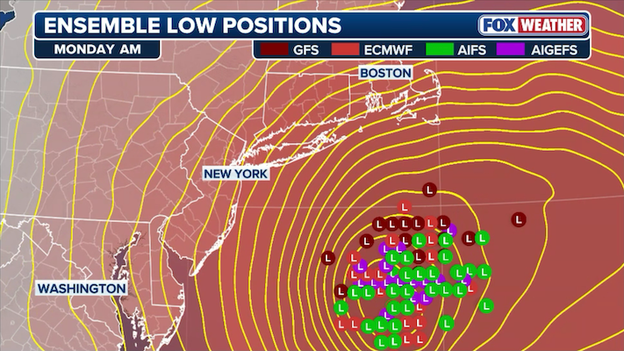
Computer forecast models show various solutions for where the storm's center will track Sunday into Monday.
This sensitivity is why models often disagree until hours before the first flake falls; a minor shift in the upper-level jet stream or a small fluctuation in key ingredients can completely redraw the snow-to-rain battleground.
Even when meteorologists correctly predict that it will snow, determining the exact snow-to-water ratio remains a massive hurdle.
While the general rule is ten inches of snow for every inch of water, reality is rarely that simple. A "wet" storm might produce heavy, slushy snow at a 6:1 ratio, while a colder, drier system could fluff that same moisture into 20 inches of powdery accumulation.
Furthermore, intense nor'easters often develop narrow mesoscale snow bands—sometimes only 5 to 10 miles wide—that can drop 3 inches of snow per hour while a neighboring town sees almost nothing.
This combination of track uncertainty, sneaky warm air, and shifting snow ratios makes every major Northeast blizzard a complex puzzle that keeps forecasters—and residents—on edge until the storm finally clears.
New York City Mayor Zohran Mamdani has scheduled an emergency press conference for 1:30 p.m. ET today at the Spring Street Salt Shed to provide critical updates as a historic blizzard begins to bear down on the five boroughs.
With New York City now under its first Blizzard Warning in years and forecasts calling for up to 18 inches of snow, the Mayor is expected to outline the final stages of the city’s mobilization, which already includes 2,000 sanitation workers and 700 salt spreaders standing by for the historic blizzard.
There is a spooky numerical trend that has New York City meteorologists scratching their heads: nearly every all-time record-breaking blizzard in the city has occurred in a year ending in the number 6.
This 10-year interval has turned the mid-winter months of 1996, 2006, and 2016 into legendary milestones for weather enthusiasts and a nightmare for city transit.
As we find ourselves in 2026, the pattern seems to be holding firm as yet another historic bomb cyclone takes aim at the I-95 corridor.
To understand the scale of what is currently brewing, we have to look back at the big three storms that defined the last three decades:
- January 1996 (The Blizzard of '96): This massive nor'easter paralyzed the Eastern Seaboard for nearly a week. Central Park recorded 20.2 inches of snow, while other boroughs saw up to 30 inches. The storm was so intense it forced the New York Stock Exchange to close early and left thousands across the region without electricity or heat for days.
- February 2006: Just 10 years later, a minor affair turned into a record-shattering event. It dumped 26.9 inches on Central Park in a single 16-hour period—the highest total recorded since 1869 at that time. Snow fell at staggering rates of 3 to 4 inches per hour, causing subway delays and cutting bus service in half.
- January 2016 (Snowzilla): Keeping the "sixes" streak alive, the storm became the most significant storm in NYC history. It dropped an all-time record 27.5 inches of snow in Central Park. The storm prompted a total travel ban for all NYC and Long Island roads, proving that even with modern preparation, a 10-year monster storm can still bring the "city that never sleeps" to a complete standstill.
New York City is bracing for 12-18 inches of snow from the historic blizzard Sunday into Monday.
With Blizzard Warnings once again hoisted for the five boroughs this weekend, it appears the "10-year curse" is right on schedule. Whether it's a quirk of atmospheric cycles or just meteorological coincidence, the Northeast is once again bracing for a generational event that could join the ranks of '96, '06, and '16 in the record books.
The latest Fox Weather Model data confirms that this nor'easter is evolving into a formidable wind event, with a bomb cyclone trajectory that will generate punishing gusts across the entire I-95 corridor.
As the storm's central pressure plummets, the tightening pressure gradient will act like an atmospheric vacuum, pulling in ferocious winds that will peak between Sunday night and Monday morning.
According to the current forecast, Nantucket is in the crosshairs for the highest land-based impacts with gusts reaching 60–70 mph, while coastal hubs like New York City, Boston, and Montauk should brace for sustained lashing at 50–60 mph.
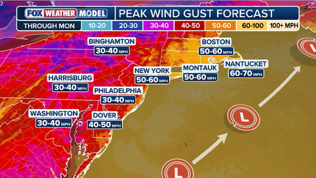
Exclusive FOX Weather Model shows the expected peak wind gusts up to 70 mph in the Northeast.
These aren't just nuisance winds; at these speeds, power outages become a near-certainty as frozen, snow-laden tree limbs snap onto utility lines.
Even further inland, cities like Philadelphia, Harrisburg, and Washington D.C. will see significant gusts in the 30–40 mph range, which will be enough to create dangerous whiteout conditions as they whip falling snow into a frenzy.
If you have loose outdoor furniture or decorations, now is the time to secure them, as this system packs the mechanical energy of a tropical storm with the added punch of a historic blizzard.
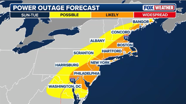
Power outage forecast showing the threat for outages along the I-95 corridor in the Northeast.
Forecasters are sounding the alarm this morning as the combination of extreme wind and heavy, wet snow creates a perfect storm for widespread power outages.
The rapidly intensifying bomb cyclone will produce wind gusts between 50-60 mph along the coast, more than enough to snap frozen tree limbs and down utility lines.
Because the initial wave of precipitation may begin as a heavy, wet "heart-attack" snow, it will likely cling to infrastructure, adding thousands of pounds of weight to the grid before the strongest winds even arrive.
Major providers like National Grid, PECO, and PSEG will likely begin pre-staging lineman today, but once blizzard conditions begin, it will be too dangerous for bucket trucks to operate, meaning any outages that occur Sunday night may not be addressed until the winds subside on Monday.
Major carriers including American, Delta, United, Southwest, and JetBlue have proactively issued travel waivers for the Northeast as a historic blizzard prepares to slam the I-95 corridor.
These alerts cover a broad range of airports from D.C. to Boston, allowing passengers scheduled to fly on Sunday, February 22, and Monday, February 23, to rebook their flights without paying change fees or fare differences.
With snow rates expected to reach 1-3 inches per hour and dangerous winds winds threatening to ground hundreds of flights, airlines are strongly urging travelers to utilize their mobile apps to move flights to earlier today or after the storm’s peak on Tuesday to avoid being stranded at major hubs like JFK, Newark, and Logan International.
Confidence has officially reached critical mass for a high-impact shutdown snowstorm that is set to paralyze the Northeast corridor starting on Sunday.
This isn't just a standard winter storm; it is a rapidly intensifying bomb cyclone that has triggered Blizzard Warnings for New York City and surrounding communities.
Major transit hubs are already sounding the alarm, with Delta, United, American, Jetblue issuing widespread travel waivers.
With snow rates expected to hit 1-3 inches per hour during the peak of the storm, city officials are warning that plows will likely be unable to keep up, leading to inevitable road closures and a suspension of surface transit across the I-95 corridor through the Monday morning commute.
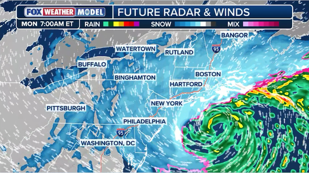
Exclusive FOX Weather Model shows the raging nor'easter hammering the Northeast on Monday morning.
Just 24 hours ago, the I-95 corridor was looking at a nuisance 1-to-3-inch event. Now, millions are under Blizzard Warnings for up to 24 inches of snow.
This dramatic forecast shift wasn't a mistake—it was the result of a high-stakes "atmospheric merger" that happened faster and closer to the coast than most reliable computer models predicted.
It comes down to three critical factors that redefined this storm in a matter of hours:
- The phasing: This storm is a result of two separate energy systems—one from the Great Lakes and one from the Southeast—phasing or merging together. Earlier this week, models thought they would stay separate, resulting in a weak, disorganized storm. Instead, they synced up like two lanes of highway traffic merging at full speed, creating a massive explosion of atmospheric energy.
- Rapid bombogenesis: The storm will undergo bombogenesis, meaning its central pressure will drop at a rate that qualifies it as a bomb cyclone. This rapid intensification does more than just increase wind; it creates its own cold air through dynamic cooling. This will ensure most of the precipitation that falls is snow.
- The westward nudge: In the world of nor'easters, 50 miles is the difference between a dusting and a disaster. High pressure over eastern Canada will act like a brick wall, shunting the storm’s track further west and hugging the coastline. This will place the heaviest snow bands—which can drop 3 inches of snow per hour—directly over the major metropolitan hubs rather than out to sea.
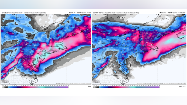
Most major computer forecast models struggled to resolve the evolution of the nor'easter in recent days. (Source: WeatherBELL)
Throughout the week, the GFS (American) model lived up to its reputation for being the enthusiastic outlier, consistently spitting out eye-popping, monster snow totals of two to three feet for the I-95 corridor.
While these maps went viral on social media, more historically reliable models like the ECMWF (European) and the UKMET remained skeptical, trending much further offshore and suggesting only a glancing blow of light snow.
However, in a dramatic atmospheric U-turn, the reliable models finally caved in the last 24 hours, shifting their tracks westward to align with the GFS's more aggressive solution and turning those crazy predictions into a looming reality for millions in the Northeast.
Nor'easters are notorious for being forecast killers because the difference between a record-breaking blizzard and a cold rain often hinges on a track shift of just 30 to 50 miles.
These dynamic systems rely on a volatile phasing of energy and rapid pressure drops that can create narrow, intense snow bands, making it nearly impossible to nail down precise totals until hours before the first flakes actually begin to fall.
For the first time in nearly a decade, New York City is officially under a Blizzard Warning, marking a dramatic escalation in the forecast for this weekend's bomb cyclone.
The FOX Forecast Center is now calling for 12-18" of snow for New York City and surrounding areas and says those numbers could go up in the hours before the storm hits.
Latest snow forecast from FOX Weather for the Northeast showing 12-24" of snow through Monday.
While earlier models hinted at a modest event, the latest data has locked in a "worst-case" track that puts the five boroughs, Long Island, and coastal New Jersey directly in the bullseye for 12 to 24 inches of snow.
This isn't just a heavy snow event; it is a true atmospheric "bomb" that will likely paralyze the region through Monday.
With visibility expected to drop to near-zero for several consecutive hours, the city is bracing for its most significant winter impact since the historic 2016 "Snowzilla" storm.
Officials are urging residents to stay off the roads to allow plow crews a fighting chance against the blinding conditions.
From major coastal flooding in Queens to power outage risks across the I-95 corridor, the Northeast is preparing for a generational blizzard that will redefine the 2026 winter season.
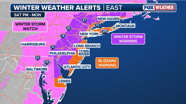
Blizzard Warnings are in effect for New York, Long Island, coastal Connecticut, and the Jersey Shore from Sunday to Monday.
History is being written in the snow today as the National Weather Service has officially placed New York City under a Blizzard Warning for the first time since March 2017.
This rare upgrade signals a dangerous shift in the storm’s trajectory, transforming what was initially expected to be a standard nor'easter into a potential "top-five" historic event for the five boroughs.
The warning covers all of NYC, Long Island, and coastal Connecticut, effective from 6:00 a.m. Sunday through 6:00 p.m. Monday, as a rapidly intensifying bomb cyclone prepares to blast the region.
The significance of a Blizzard Warning for New York City cannot be overstated. By definition, a blizzard isn't just about how much snow falls, but the visibility and wind speed. Forecasters are calling for sustained winds of 35 mph with gusts up to 60+ mph, which will combine with snowfall rates of 1 to 3 inches per hour to create total whiteout conditions.
With current totals projected between 12 and 18 inches—and snow drifts expected to reach 3 feet—city officials are warning that travel will be "treacherous and life-threatening."
The "blizzard" criteria requires these conditions to last for at least three consecutive hours, a benchmark this storm is expected to shatter Sunday night.
Beyond the blinding snow, the storm's "bombing" pressure is expected to drive a significant coastal surge, threatening low-lying areas in Queens and Staten Island with flooding during the Sunday night high-tide cycle.
As the city braces for its first true blizzard in nearly a decade, the message is clear: this is a "major winter storm" that will likely paralyze the tri-state area through Monday.
You’ve reached the beginning of this live coverage.