Weather whiplash in central, southern US as above-average temperatures plummet
In advance of the cold, the Plains will see high temperatures 10 to 20 degrees above average to kick off the workweek
Temperatures in central, southern US take a rollercoaster ride this week
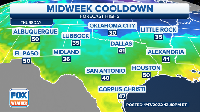
In advance of the cold, the Plains will see high temperatures 10 to 20 degrees above normal to kick off the workweek. By Thursday, those temperatures will be replaced by highs in the 30s and 40s and lows in the teens.
First they're up, then they're down. The thermometer is moving all around.
It's a weather whiplash on a wild ride of temperatures this week as many wonder what jacket they might need when they head out the door.
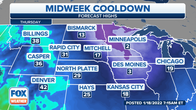
Behind a clipper system in the Midwest, an arctic high-pressure system will drop out of Canada and into the Central Plains, bringing with it frigid temperatures toward the end of the week.
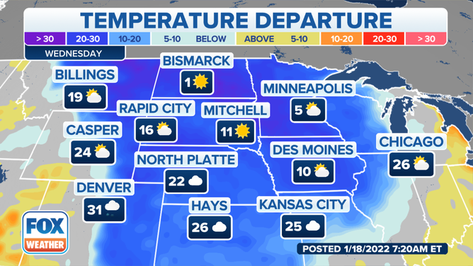
In advance of the cold, the Plains will see high temperatures 10 to 20 degrees above average to kick off the workweek.
In the Northern Plains, the arctic air will move in on Wednesday and linger through the end of the week. Highs will be in the teens to below zero, with widespread below-zero low temperatures.
(FOX Weather)
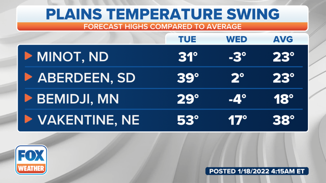
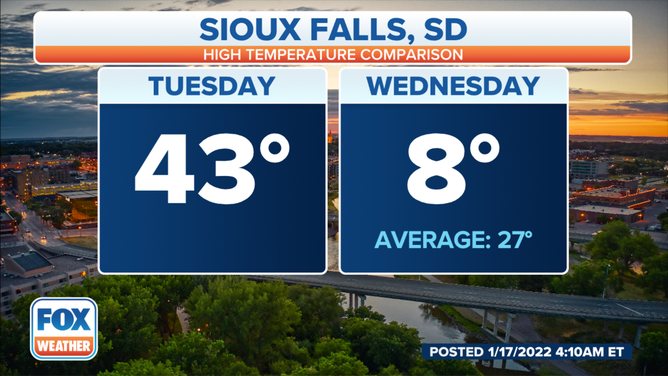
On Tuesday, Sioux Falls, South Dakota, is forecast to see a 43-degree high, but it will be a bone-chilling 8 degrees by Wednesday.
(FOX Weather)
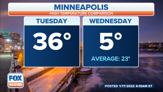
Minneapolis will have a high of 36 degrees Tuesday before plummeting into the single digits.
(FOX Weather)
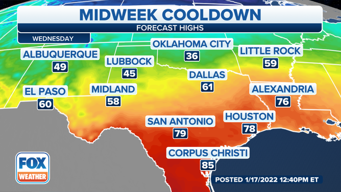
After a winter storm dropped temperatures across the South over the weekend, the southern U.S. rebounds midweek before another weekend cooldown. Highs will be in the 70s and 80s across Texas Tuesday into Wednesday.
(FOX Weather)
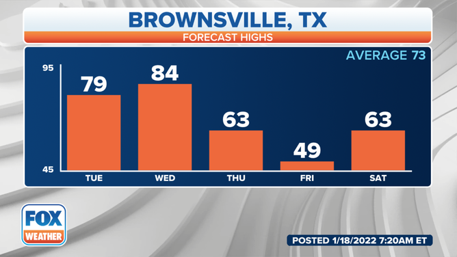
Brownsville, Texas, could see a record high on Wednesday. The current forecast is 83 degrees. The record is 84 degrees set back in 2009.
(FOX Weather)
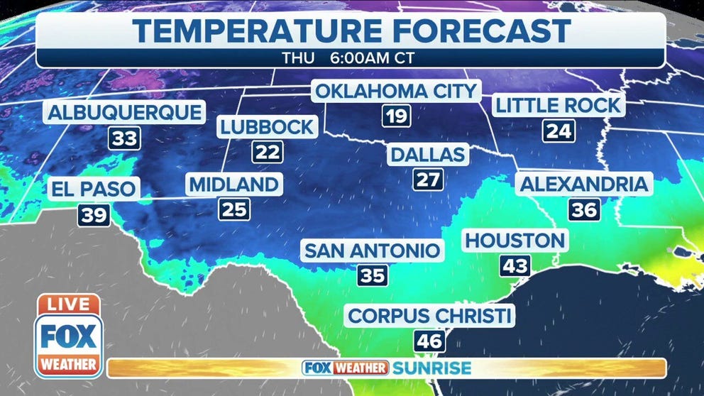
By Thursday, those temperatures will be replaced by highs in the 20s and 30s and lows in the teens. Wind chills will dip into the single digits.
(FOX Weather)
The cold air spreads east and south late week, with below-average temperatures reaching the Gulf Coast and Florida by the weekend.