Brewing ‘Super’ El Niño may self-destruct after reaching record peak, triggering rapid La Niña return in 2027
These extreme events are not built for endurance. In fact, the stronger the El Niño event becomes, the more rapidly they tend to self-destruct.

Why Super El Niño likely sets the stage for La Niña in 2027
A historically strong Super El Niño is forecast to take hold sometime this summer, virtually shutting down hurricane formation in the open waters of the Atlantic and unleashing a stormy second half of the year for the southern U.S. However, the record-breaking strength of this El Niño could lead to its own rapid collapse. According to the FOX Forecast Center, since 1970, there have been five recorded Super El Niño events followed by a swift decline into either neutral or La Niña conditions.
A historically strong Super El Niño is forecast to take hold sometime this summer, virtually shutting down hurricane formation in the open waters of the Atlantic and unleashing a stormy second half of the year for the southern U.S.
However, the record-breaking strength of this El Niño could lead to its own rapid collapse.
NEW DATA REVEALS 100% CHANCE OF STRONG ‘SUPER’ EL NIÑO FORMING THIS YEAR

(FOX Weather)
According to the FOX Forecast Center, since 1970, there have been five recorded Super El Niño events followed by a swift decline into either neutral or La Niña conditions.
WHAT ARE EL NINO AND LA NINA CLIMATE PATTERNS?
El Niño is one of three phases of a climate cycle called the El Niño-Southern Oscillation (ENSO). It describes natural temperature changes in the central Pacific Ocean that alter atmospheric circulation and can greatly influence global weather.

This graphic shows the part of the Central Pacific Ocean that determines El Niño, La Niño or Neutral conditions, which influence global weather patterns.
(FOX Weather / FOX Weather)
El Niño describes warmer than average water across the equatorial Pacific, while La Niña describes colder than average water conditions, and ENSO neutral refers to a state where temperatures are close to average.
BREWING SUPER EL NIÑO COULD TURN THE CALIFORNIA COAST INTO A SUMMER HOTSPOT FOR GREAT WHITE SHARKS
During El Niño, above-average water temperatures in the central and eastern Pacific Ocean produce strong winds that hinder tropical development in the Atlantic and enhance development in the Eastern Pacific, where hurricane season begins this Friday.
![Flooding in Tulare County, California.]() Image 1 of 3
Image 1 of 3Flooding in Tulare County, California, in Jan. 2023, which was an El Niño winter. (Tulare County Fire Department/Facebook)
![]() Image 2 of 3
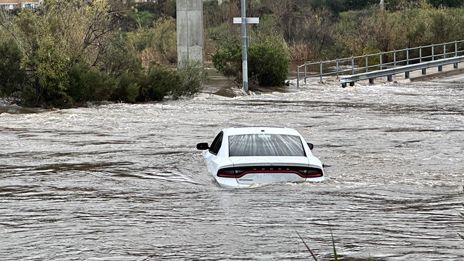
Image 2 of 3A car is seen submerged in water by San Diego River in Jan. 2023, which was an El Niño winter. (NWS San Diego)
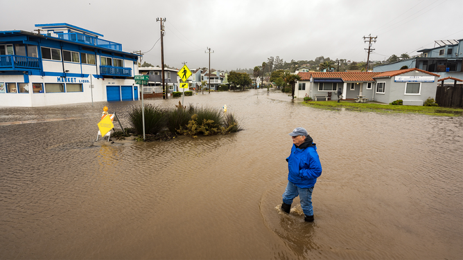
![A pedestiran wades through a flooded neighborhood in Aptos, California, US, on Saturday, Jan. 14, 2023. Storm-weary California is bracing for new round of drenching rains, heavy snowfall and dangerous winds as the death toll from a series of atmospheric rivers reached 19 people.]() Image 3 of 3
Image 3 of 3A pedestiran wades through a flooded neighborhood in Aptos, California, US, in Jan. 2023, which was an El Niño winter. (Nic Coury/Bloomberg)

Furthermore, El Niño tends to bring increased storms across the southern U.S., from California to Florida, as well as drier conditions for the Northern Tier from Washington to Ohio.
It also tends to spike temperatures worldwide, as heat is released from the Pacific Ocean.
In a strange twist, the storms that define El Niño, which are fueled by the same warm water, eventually lead to its downfall.
Through a process known as atmospheric venting, these storms transfer heat from the ocean surface. Warm water sends air rising high into the atmosphere, releasing that heat in the form of clouds and thunderstorms.

(FOX Weather / FOX Weather)
This dispersal of heat is exactly why global temperatures often spike during El Niño years; the ocean is effectively exhaling its stored warmth across the globe.
EL NIÑO EXPECTED TO DRIVE ATLANTIC STORM ACTIVITY AS COUNTDOWN TO HURRICANE SEASON BEGINS
However, this massive energy displacement cannot last forever.

(FOX Weather / FOX Weather)
According to the FOX Forecast Center, once that reservoir of heat is exhausted, the system reaches a breaking point and the chain reaction reverses.
"As the ocean surface begins to cool, the trade winds that had weakened or reversed during the peak of the event surge back to life," the Forecast Center said.
HURRICANE SEASON 2026: THESE ARE THE STORM NAMES YOU'LL SEE THIS SEASON
"These winds push any remaining warm water toward Asia, which allows for upwelling. This process pulls cold water from several hundred meters below the surface back up to the top, rapidly chilling the Pacific."

A massive pool of warm water which has been building in the Western Pacific, is now "sloshing" eastward. The thermocline is the invisible boundary layer that separates the warm, sun-lit surface water from the freezing, deep ocean water. During El Niño, as the trade winds weaken, that deep pool of warm water moves east, pushing the thermocline down in the East Pacific. This prevents cold water from "upwelling" to the surface, allowing temperatures to skyrocket.
(FOX Weather / FOX Weather)
The rapid cooldown leads directly to a La Niña.
In looking at the previous Super El Niño years since 1970, four out of five instances were followed immediately by La Niña the next year.
If this pattern holds, the extreme heat of the current cycle is setting the stage for a return to La Niña in 2027.

Super El Niño generally followed by La Niña.
(FOX Weather / FOX Weather)
La Niña is generally characterized by colder, wetter winters across the Northern Tier, while the southern U.S. is generally drier.
La Niña also tends to supercharge the hurricanes in the Atlantic Ocean's Main Development Region.