Rare October storm soaks Southern California as heavy rain drenches areas impacted by January wildfires
A rare-for-California Severe Thunderstorm Watch was issued for parts of Southern California, including Los Angeles, through Tuesday morning. This marked the first Severe Thunderstorm Watch for the Los Angeles area in more than 17 years, since Jan. 27, 2008.

Rain records fall across Southern California after rare October storm
A potent upper-level area of low pressure and associated dip in the jet stream created numerous severe storms and flash flooding across portions of Southern California on Tuesday. 3-5 inches of rain were reported across Los Angeles county as rain records fell across Southern California.
LOS ANGELES – Southern California is drying out after a potent severe storm system brought strong thunderstorms and bursts of record-setting rain, which caused localized flash flooding and prompted evacuation warnings for parts of Los Angeles that are particularly vulnerable to mudslides.
This area included Pacific Palisades, which was devastated by January's wildfire disaster. All evacuation warnings have since been lifted.
![]() Image 1 of 10
Image 1 of 10LOS ANGELES, CALIFORNIA - OCTOBER 14: Water flows past trees in the Los Angeles River, swollen by storm runoff, on October 14, 2025 in Los Angeles, California. A strong atmospheric river storm is hitting Southern California today, triggering evacuation warnings in the Eaton and Palisades fire burn scars due to debris flow fears. (Photo by Mario Tama/Getty Images) ( )
![]() Image 2 of 10
Image 2 of 10San Diego, CA - October 14: Traffic backs up on southbound Interstate 805 in Sorrento Valley during a steady rain on San Diego, CA. (K.C. Alfred / The San Diego Union-Tribune via Getty Images) ( )
![]() Image 3 of 10
Image 3 of 10PACIFIC PALISADES, CA - OCTOBER 14, 2025 -- Workers clear debris from a business destroyed in the Palisades fire as scattered downpours, powerful winds and fears of flooding continue to threaten areas of the Pacific Palisades on October 14, 2025. The recent rain prompted evacuation warnings for residents near recent burn areas in the Pacific Palisades. (Genaro Molina/Los Angeles Times via Getty Images) ( )
![]() Image 4 of 10
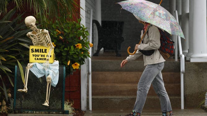
Image 4 of 10Encinitas, CA - October 14: A woman walks in the rain along Coast Highway as a skeleton is displayed outside of a shop on October 14, 2025 on Encinitas, CA. (K.C. Alfred / The San Diego Union-Tribune via Getty Images) ( )
![]() Image 5 of 10
Image 5 of 10LOS ANGELES, CALIFORNIA - OCTOBER 14: A man who said he has been experiencing episodic homelessness watches water flow in the Los Angeles River, swollen by storm runoff, on October 14, 2025 in Los Angeles, California. A strong atmospheric river storm is hitting Southern California today, triggering evacuation warnings in the Eaton and Palisades fire burn scars due to debris flow fears. (Photo by Mario Tama/Getty Images) ( )
![]() Image 6 of 10
Image 6 of 10LOS ANGELES, CALIFORNIA - OCTOBER 14: An aerial view of water flowing in the Los Angeles River, swollen by storm runoff, with the downtown LA skyline beyond on October 14, 2025 in Los Angeles, California. A strong atmospheric river storm is hitting Southern California today triggering evacuation warning in the Eaton and Palisades fire burn areas due to debris flow fears. (Photo by Mario Tama/Getty Images) ( )
![]() Image 7 of 10
Image 7 of 10PACIFIC PALISADES, CA - OCTOBER 14, 2025 -- Workers clear debris from a business destroyed in the Palisades fire as scattered downpours, powerful winds and fears of flooding continue to threaten areas of the Pacific Palisades on October 14, 2025. The recent rain prompted evacuation warnings for residents near recent burn areas in the Pacific Palisades. (Genaro Molina/Los Angeles Times via Getty Images) ( )
![]() Image 8 of 10
Image 8 of 10Monrovia, CA - October 14: A pedestrian runs across the street with an umbrella amid the rain in Monrovia Tuesday, October. 14, 2025. A brief but substantial storm brings heavy rain, thunderstorms and flooding to Southern California today, prompting evacuation warnings for residents near recent burn areas. The storm is expected to produce between three-quarters of an inch to an inch-and-a-half of precipitation across most areas, with 2 to 4 inches possible on south-facing mountain slopes. (Allen J. Schaben / Los Angeles Times via Getty Images) ( )
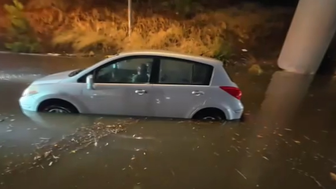
![Video from Monday night showed flooding on Interstate 280 near San Jose which trapped several cars which had to be towed out of high waters.]() Image 9 of 10
Image 9 of 10Video from Monday night showed flooding on Interstate 280 near San Jose which trapped several cars which had to be towed out of high waters. (KTVU)
![Heavy rain seen on Highway 17 in the Santa Cruz Mountains. Caltrans temporarily shut down parts of Highway 1 for crews to clear debris]() Image 10 of 10
Image 10 of 10Heavy rain seen on Highway 17 in the Santa Cruz Mountains. Caltrans temporarily shut down parts of Highway 1 for crews to clear debris. (KTVU)


Evacuation warnings were issued for areas impacted by the Palisades, Hurst and Sunset fires.
Los Angeles officials said Monday night that mandatory evacuations were ordered for 114 homes within the greater evacuation warning for properties deemed to be at greatest risk of mudslides or debris flows. Officials said police officers went door to door visiting those high-risk homes.
MICROBURST WREAKS HAVOC, LEAVES TRAIL OF DAMAGE IN TEMPE AS ARIZONA SLAMMED BY STRONG THUNDERSTORMS

Heavy rain from rare October storm floods Los Angeles streets
The San Gabriel Mountains reported some rainfall totals of over 5 inches, but most areas around the greater Los Angeles area received between 3 and 5 inches of rain. The precipitation caused street flooding in places like North Hollywood and led to numerous weather-related road closures across Southern California Tuesday.
Other locales under the evacuation warning included Malibu, Topanga Canyon, Mandeville Canyon, Altadena and other communities in the foothills of the San Gabriel Mountains.
Mandatory evacuations were also issued for parts of Orange County, and San Luis Obispo County issued shelter-in-place orders for people living inside the Gifford and Madre Fire burn scars.
According to the National Weather Service, ash from wildfires creates burn scars – a water-repellent coating that prevents the ground from absorbing water and causes the area to be predisposed to flash flooding and debris flows.
WHAT IS A WILDFIRE BURN SCAR AND HOW COULD THEY HAVE LASTING IMPACTS?

A roof collapsed at a movie studio in Sun Valley, Calif. on Oct. 14, 2025.
(FOX 11)
The San Gabriel Mountains reported some rainfall totals of over 5 inches, but most areas around the greater Los Angeles area received between 3 and 5 inches of rain.
Scotland, California, in the San Bernardino Mountains, tallied nearly 6 inches of rain, leading rainfall totals across the state Tuesday.
Burbank recorded 2.37 inches of rain Tuesday, becoming the rainiest October day in the city's history.
Late Tuesday morning, the roof of a movie studio in Burbank collapsed from heavy rain, according to FOX 11 Los Angeles.
Wind gusts even reached hurricane-force in Los Angeles County, where Acton recorded a gust of 73 mph.

A car drives through a flooded street in Rosemead, California, on Oct. 14, 2025.
(Photo by Frederic J. Brown / AFP) (Photo by FREDERIC J. BROWN/AFP via Getty Images / Getty Images)
Flash flooding covers major roads
The Pacific Coast Highway in Huntington Beach was closed in the southbound direction due to flooding on Tuesday afternoon, CalTrans reported.
Heavy rain also pelted Malibu during the morning rush Tuesday. The City of Malibu announced that Topanga Canyon was closed and warned drivers about rockfalls in Malibu Canyon.

Heavy rain during morning commute as potent storm system triggers evacuation warnings in Malibu
Heavy rain pelted Malibu, California on Tuesday morning, which is under an evacuation warning. Evacuation warnings are in effect for parts of Los Angeles, which are particularly vulnerable to mudslides, as a potent severe storm system charges southward across California.
The northbound lanes of busy Interstate 5 were also closed due to flooding north of Burbank in Sun City for a period Tuesday afternoon. Two lanes reopened later in the evening.
A rare-for-California Severe Thunderstorm Watch was issued for parts of Southern California, including Los Angeles, through Tuesday morning. This marked the first Severe Thunderstorm Watch for the Los Angeles area in more than 17 years, since Jan. 27, 2008.

Powerful storms target parts of California
Dr. Ariel Cohen, a Meteorologist for the National Weather Service in Los Angeles, joins FOX Weather to discuss the latest severe weather expected to hit parts of California, as flood watches are in effect for specific regions.
Storm brings heavy rain to Bay Area, snow to Sierra Nevada
Heavy rain from the same storm system doused Northern California on Monday, including the San Francisco Bay Area.

Severe storms cause road flooding in San Jose, California
Video from Monday night showed flooding on Interstate 280 near San Jose, California which trapped several cars that had to be towed out of high waters. A strong area of low pressure brings heavy rain, thunderstorms and even a rare tornado threat across Southern California through Wednesday.
Video from Monday night showed flooding on Interstate 280 near San Jose, which trapped several cars that had to be towed out of high waters.
The same system will also bring snow to the Sierra Nevada mountain range at elevations higher than 6,000 feet, with 2-3 feet of snow expected at the highest peaks. CalTrans closed the Sonora Pass last Friday ahead of the storm.