Historically smoky skies in New York can be traced back to September's Hurricane Fiona
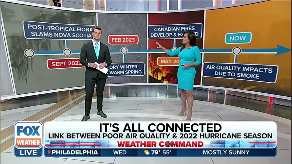
"This one proves how everything is connected in weather," said FOX Weather Meteorologist Stephen Morgan. "We're going to trace back the current poor air quality to last year's hurricane season."
How last year's hurricane season helped lead to this year's wildfires
The smoke currently smothering the Northeast from the Canadian wildfires can trace its origins to a chain of weather events stretching back to Hurricane Fiona in 2022.
NEW YORK – As thick smoke continues to pour into the Northeast and Great Lakes from massive wildfires burning in eastern Canada; the FOX Weather Center has been able to connect the chain of weather events that link the current fires to Hurricane Fiona, which eventually crashed into Nova Scotia last September.
"This one proves how everything is connected in weather," said FOX Weather Meteorologist Stephen Morgan. "We're going to trace back the current poor air quality to last year's hurricane season."
HOW DO WILDFIRES AND THEIR SMOKE EXACERBATE MEDICAL CONDITIONS?
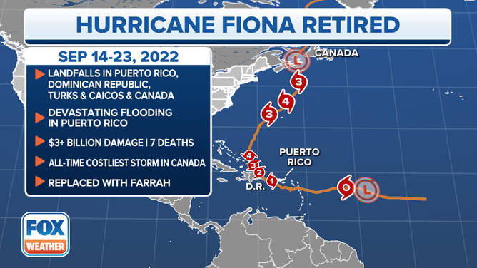
Hurricane Fiona formed in mid-September, tracking through the Caribbean before turning north off and swirling off the Atlantic Seaboard – eventually reaching Category 4 status.
(FOX Weather)
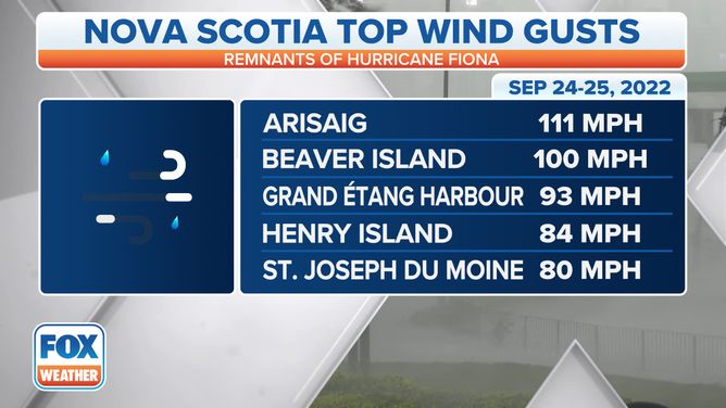
As the storm moved north into cooler waters, the storm weakened into a post-tropical cyclone but still and enough power to strike eastern Nova Scotia as an equivalent of a Category 1 hurricane.
"This system moved right over a very wooded part of Canada -- the Acadian Forest in Nova Scotia," Morgan said. "Strong winds downed thousands of trees and power lines."
(FOX Weather)
All those downed trees were the first ingredient for a future inferno.
"You've got all this vegetation just dead, lying around, basically lying in wait," said FOX Weather Meteorologist Amy Freeze.
Fiona would leave more than $3 million in damage in the Canadian Maritimes.
A dry and mild winter and spring
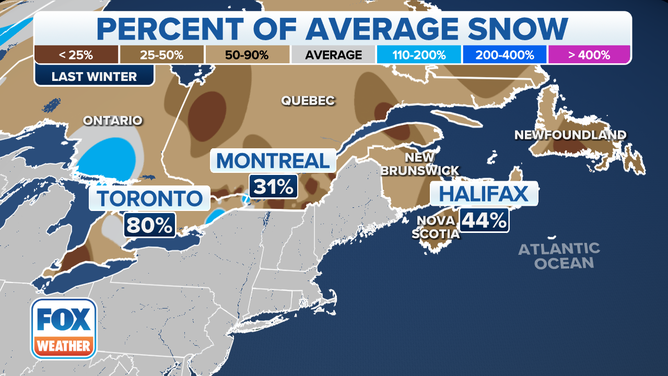
As the calendar drifted into winter, the weather didn't really follow suit. For all the headlines the Northeast made for lack of snow, a similar story played out just across the border.
"So it all dries out," Morgan said.
We reach February, and it's finishing up a dry winter. Halifax, Nova Scotia, only received 44% of its average snowfall.
(FOX Weather)
Spring beings dry and warm, and by May, "Everything is dry, brittle and fuel for a fire," Freeze said. "The vegetation is basically the kindling that you would get the fire started."
"It continues to rot and dry out," Morgan said. "And it's very easy to catch fire."
Western Canada goes up in flames first
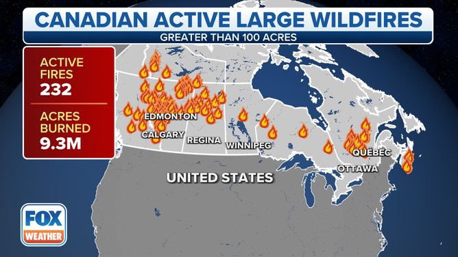
May ended up the warmest on record in western Canada, which sees dozens of wildfires in Alberta and then into British Columbia. The fires stretch Canada's firefighters thin.
WHAT TO DO WHEN WILDFIRE SMOKE SMOTHERS YOUR AREA, AND HOW TO KEEP YOUR HOME'S AIR CLEAN
"You get the fires erupting amid record heat up in Canada," Freeze said. "And all of a sudden, the provinces are on fire, and they can't really handle them because now at this point, you have 200 fires, and most of them are reportedly out of control."
(FOX Weather)
Nova Scotia's coast also has among its warmest May. Then, the wildfires started and quickly grew with so many dead, dry timbers around. It eventually burned over 60,000 acres and became the largest wildfire in Nova Scotia's history. The fire is still burning, with firefighting resources still stretched very thin through the country, though cooling rains have reached the region in the last few days.
Around Memorial Day, a low-pressure center off New England began steering smoke into New England. Most of it was elevated but brought a haze to the skies.
Lately, new fires that began in Quebec were triggered by thunderstorms, erupting in size and now, new sources to pump out smoke.
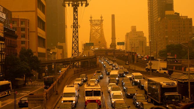
NEW YORK, NEW YORK - JUNE 7: Traffic goes over the Ed Koch Queensboro Bridge as smoke from Canadian wildfires casts a haze over the area on June 7, 2023 in New York City. Air pollution alerts were issued across the United States due to smoke from wildfires that have been burning in Canada for weeks.
(Eduardo Munoz Alvarez / Getty Images)
Unfortunately, the weather pattern was locked in the worst spot for New York and New England, with a stubborn area of low pressure locked offshore and a high-pressure ridge anchored over central Canada, both working to funnel clouds and smoke from Quebec into the Northeast, giving New York City its worst air quality ever measured.