Large hail pelts Texas, Oklahoma while landspout swirls through Kansas Tuesday
A landspout was seen spinning through a Kansas field, and large hail pounded portions of Texas and Oklahoma.
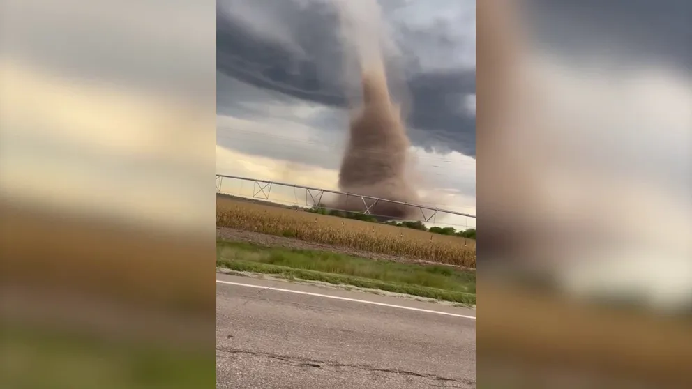
Massive landspot tornado rips through farm fields near Rush Center, Kansas
A landspout tornado was captured on video as it spun through a field in Rush Center, Kansas, at 5:50 p.m. Tuesday. Severe storms and heavy rain were in the forecast across the Plains with a bull’s-eye on Oklahoma and portions of North Texas.
Severe storms and heavy rain return to the Plains on Tuesday with a bull’s-eye on Oklahoma and portions of North Texas.
A front moved through the region, igniting thunderstorms within the forecast area.
FALL IS THE SECOND SEVERE WEATHER SEASON
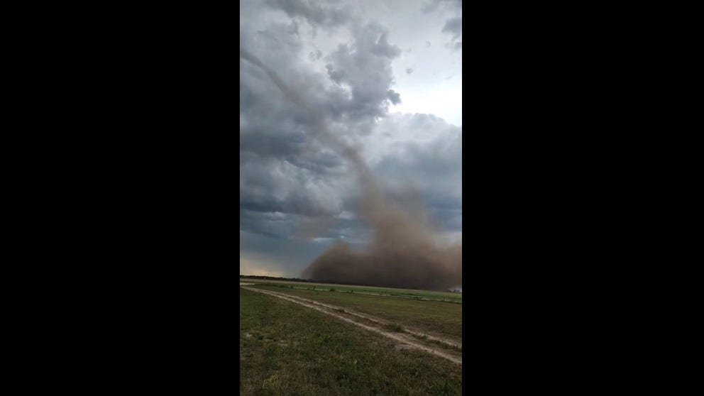
Landspout swirls through Kansas on Tuesday evening
A landspout was seen moving through Nekoma, Kansas, on Tuesday evening. The Plains were under a severe weather threat through late Tuesday.
Western Oklahoma and Kansas began the day with showers and thunderstorms, but with enough daytime heating, storms ignited again on Tuesday afternoon.
A landspout was seen spinning through a field south of Hayes, Kansas.
![]() Image 1 of 2
Image 1 of 2A shot of the base of the landspout in Nekoma, KS. (@clintonkershner via X)
![]() Image 2 of 2
Image 2 of 2A landspout was seen near La Crosse, Kansas, Tuesday evening. (RedHillsRancher)


In places like North Texas, large hail fell amid Severe Thunderstorm Warnings.

Large hail pelts Quanah, Texas, Tuesday evening
North Texas and Oklahoma were under a Severe Thunderstorm Watch on Tuesday evening. Large hail was seen across the region as storms rolled through.
"The downside to this hail is it's going to be flying at you anywhere between 40 mph to upwards of potentially 80 mph," FOX Weather meteorologist Jason Frazer said. "That means that anything that you have outside, you are going to need to be on alert for."
WATCH VS. WARNING: HERE ARE THE DIFFERENCES BETWEEN THESE WEATHER TERMS THAT COULD SAVE YOUR LIFE

(FOX Weather)
THE 5-POINT SEVERE THUNDERSTORM RISK CATEGORY SCALE EXPLAINED
Heavy rain will also likely lead to a few instances of flash flooding. Generally, widespread 1 to 2 inches of rain looks likely, with some locations getting up to 3 inches.
Central Oklahoma is largely drought-free, but drought conditions are present along the state borders with Kansas and Texas. Any rain farther north, closer to Wichita, or farther south toward Wichita Falls is greatly needed.
ADVICE FOR DEALING WITH STORM ANXIETY WHEN SEVERE WEATHER THREATENS

(FOX Weather)
The storms are just the first salvo in what is shaping up to be a rather stormy week in the Plains, with varying levels of severe weather threats each day into the early part of the weekend.