Watch: Exclusive Storm Tracker vehicles damaged by significant hail as severe storms pummel the Plains
Wednesday's storms brought a renewed risk of flash flooding, hail and damaging winds to residents across western Texas, Oklahoma and western Kansas.

Damaging hail takes out windshield in Texas
Large hail and glass do not mix. See the extent of the damage from FOX Weather Exclusive Storm Tracker Brandon Copic.
AMARILLO, Texas – When the National Weather Service issues alerts for damaging hail, it’s a clear sign that thunderstorms mean business, and that’s exactly what storm trackers found out on Wednesday.
Numerous chasers across the Lone Star State reported shattered windows and busted headlights as a barrage of large, unforgiving hail pummeled the region during a round of severe thunderstorms.
While no significant injuries were reported, those who found themselves caught in the hail cores are now facing costly repairs.
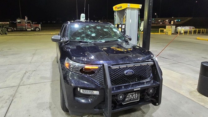
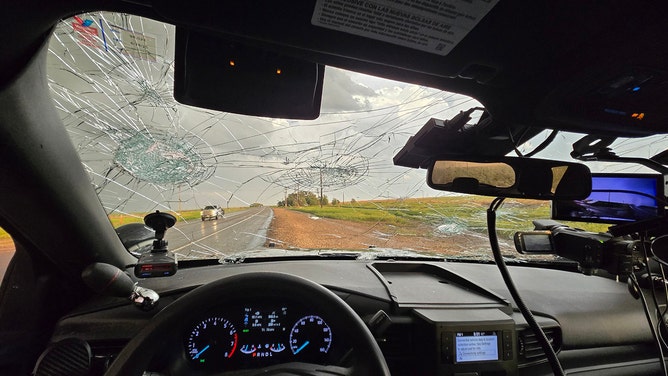
![Large hail and glass do not mix. See the extent of the damage from FOX Weather Exclusive Storm Tracker Brandon Copic.]() Image 1 of 7
Image 1 of 7Large hail and glass do not mix. See the extent of the damage from FOX Weather Exclusive Storm Tracker Brandon Copic. ( Brandon Copic)
![Large hail and glass do not mix. See the extent of the damage from FOX Weather Exclusive Storm Tracker Brandon Copic.]() Image 2 of 7
Image 2 of 7Large hail and glass do not mix. See the extent of the damage from FOX Weather Exclusive Storm Tracker Brandon Copic. ( Brandon Copic)
![Large hail and glass do not mix. See the extent of the damage from FOX Weather Exclusive Storm Tracker Brandon Copic.]() Image 3 of 7
Image 3 of 7Large hail and glass do not mix. See the extent of the damage from FOX Weather Exclusive Storm Tracker Brandon Copic. ( Brandon Copic)
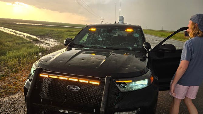
![FOX Weather Exclusive Storm Tracker Brandon Copic said both windshield and headlights were a total loss following monster hail in Texas on Wednesday.]() Image 4 of 7
Image 4 of 7FOX Weather Exclusive Storm Tracker Brandon Copic said both windshield and headlights were a total loss following monster hail in Texas on Wednesday. (Brandon Copic)
![Large hail and glass do not mix. See the extent of the damage from FOX Weather Exclusive Storm Tracker Brandon Copic.]() Image 5 of 7
Image 5 of 7Large hail and glass do not mix. See the extent of the damage from FOX Weather Exclusive Storm Tracker Brandon Copic. ( Brandon Copic)
![Damaging hail outside of Dimmitt, Texas, on 4/23/2025]() Image 6 of 7
Image 6 of 7Damaging hail outside of Dimmitt, Texas, on 4/23/2025 (@CoreyGerkenWX)
![Damaging hail outside of Dimmitt, Texas, on 4/23/2025]() Image 7 of 7
Image 7 of 7Damaging hail outside of Dimmitt, Texas, on 4/23/2025 (@CoreyGerkenWX)


According to NWS meteorologists, any hailstone measuring 1 inch or more is considered severe and on Wednesday, some hailstones were estimated to be between 2 and 4 inches in diameter, with some possibly even larger in isolated cases.
"They’re bigger than baseballs and going through the windshield," FOX Weather Exclusive Storm Tracker Brandon Copic said over the radio to fellow chasers.
FOX Weather's Corey Gerken was near Dimmitt, Texas, when his vehicle's paint job was ruined, then eventually the windshield.
Fortunately, all appeared to be in good spirits afterward - chalking it up as just another day on the job.
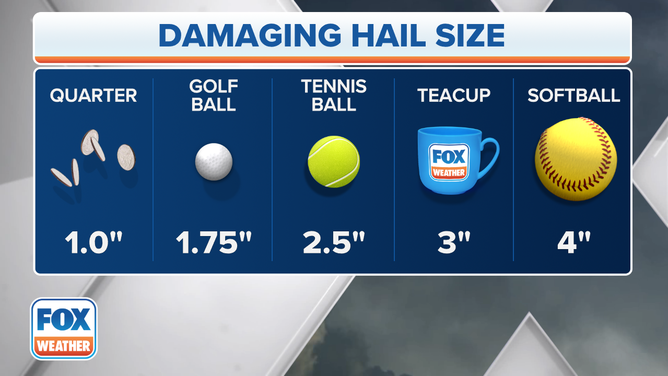
Hail Size Chart
(FOX Weather)
NOAA's Storm Prediction highlighted parts of Kansas, Oklahoma and Texas as being under a Level 2 out of 5 severe weather risk, with hail and damaging winds being the primary concerns.
Tornadoes spotted in rural Texas, Oklahoma on Thursday
There was no rest for the weary in the Texas and the Oklahoma panhandles again for severe storms as the pattern repeated on Thursday.
While communities such as Amarillo and Lubbock were on the lookout for large hail, tornadoes were spotted across the Southern Plains.

Tornado captured on video swirling in Texas Panhandle
FOX Weather Storm Tracker Brandon Copic captured a tornado on camera as he was monitoring a severe thunderstorm in Lockney, Texas Thursday evening.
There were no reports of immediate damage from the tornadic supercells, as thunderstorms were centered away from major population centers.
A 5.2-inch-wide hailstone was reported by a storm chaser in Flomot, Texas, but it was well below state records.
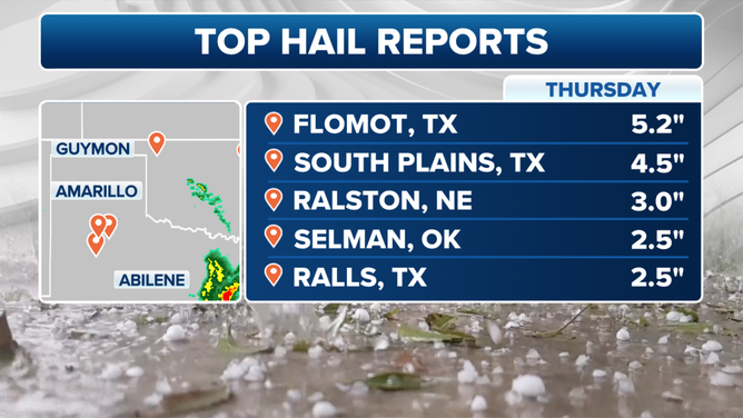
Top hail reports from the Southern Plains
(FOX Weather)
Midland slammed by 112 mph wind gust Tuesday
One of the strongest cells hit Midland, Texas, with what the National Weather Service said brought a severe wind gust that may have even topped 100 mph, thanks to a potential "virga bomb." When a thunderstorm's heavy rains fall into super-dry air, the rain can evaporate, cooling the air and making it rush to the ground at extreme speeds.
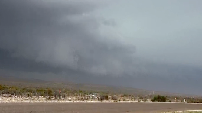
A wall cloud looms over Fort Stockton, Texas, on April 22, 2025.
(Brandon Copic)
Parts of the Southern Plains were slammed with severe storms Tuesday evening, the first of a two-day severe weather threat for parts of the region.
The official wind gauge at Midland Airport briefly recorded a peak gust of 112 mph. The NWS will have to verify such an extreme wind speed report, but said there were certainly strong wind gusts observed near the storm.
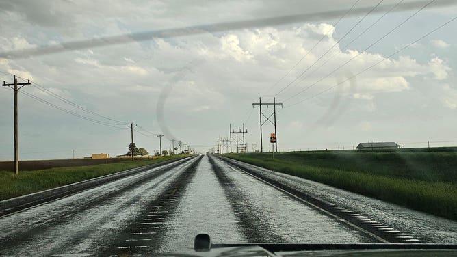
Flash flooding has been observed in various areas in west Texas, as some roads are covered by six inches of rushing water, according to the National Weather Service.
Another strong thunderstorm slowly rolled through Fort Stockton, Texas, where wind gusts were clocked at 68 mph as a severe-warned storm moved through the area. The city recorded 0.78 inches of rain in just one hour on Tuesday evening.
Another gust reached 63 mph in Lakeview, according to National Weather Service spotter reports.
Tuesday night brought a wild hailstorm to the Austin, Texas, suburbs. Georgetown was hit hard by quarter-sized hail, leaving damage to cars.
Some areas, such as Sanderson, Texas, reported baseball-sized hail measuring over two and a half inches according to the National Weather Service.
DOWNLOAD THE FREE FOX WEATHER APP

Landspout tornado spotted in Imperial, Texas
FOX Weather Storm Tracker Brandon Copic happened upon a landspout tornado as he was tracking storms in west Texas Tuesday.
A repeat of the severe storms will be in place on Thursday too as the dryline makes forward progress once again in the afternoon.