Severe Thunderstorm Watch issued as damaging wind, large hail could erupt in the mid-Atlantic, Southeast
Flash flooding is also possible across the Carolinas, where up to an inch of rain is possible through Tuesday, according to the FOX Forecast Center.
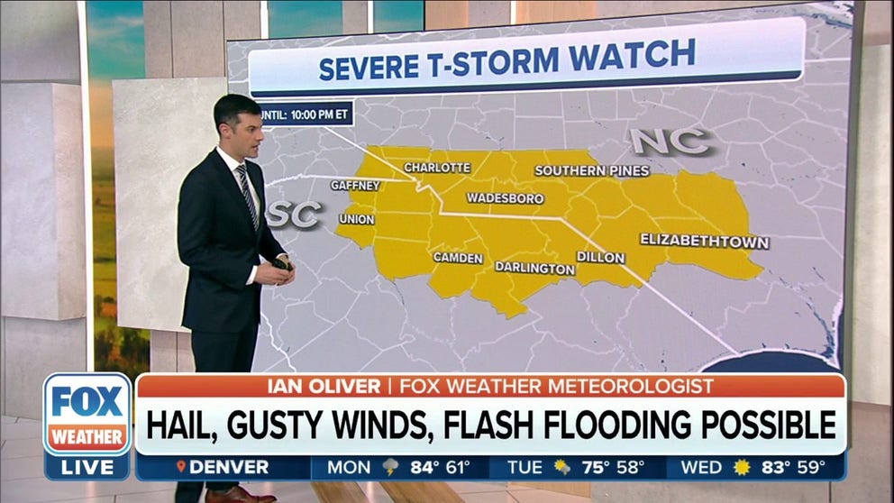
Severe Thunderstorm Watch for Carolinas until late Monday
Severe Thunderstorm Watch has been issued for parts of North Carolina and South Carolina until 10 p.m. ET. Damaging wind, large hail and frequent lightning are possible with storms.
Parts of the mid-Atlantic and Southeast are bracing for possible severe thunderstorms packing large hail, damaging wind and even a few tornadoes on Monday.
A Severe Thunderstorm Watch was issued in the Carolinas until 10 p.m. ET.
(FOX Weather)
Flash flooding is also possible across the Carolinas, where up to an inch of rain is possible through Tuesday, according to the FOX Forecast Center.
HOW TO WATCH FOX WEATHER ON TV

(FOX Weather)
The threat of severe weather exists across an area stretching from the Carolinas into central and northern Georgia, including Atlanta and central Alabama.
However, there is a greater risk of severe thunderstorms across central and southern North Carolina and north-central South Carolina.
THE 5-POINT SEVERE THUNDERSTORM RISK CATEGORY SCALE EXPLAINED
The severe weather threats

(FOX Weather)
"We're going to be tracking a line of storms that will be targeting the Carolinas today, and it is going to be bringing with it a risk of not only damaging wind but also some hail as well," FOX Weather meteorologist Jason Frazer said. "When we're talking about some of these damaging winds, we're talking about winds anywhere in excess of about 40 to 50 mph, and that could lead to some power outages."
Damaging winds aren't the only threat from any of the thunderstorms that pop up during the day.
Dangerous cloud-to-ground lightning, large hail and tornadoes are also possible.
WHEN THUNDER ROARS, EVEN TAKING OUT THE TRASH CAN TURN DEADLY
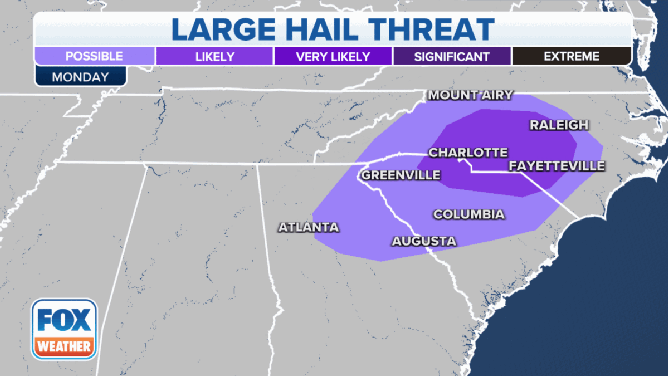
The threat of tornadoes and large hail on Monday, Aug. 15.
(Getty Images)
The threat of large hail sits across a wide area from the Carolinas to Georgia, but the highest threat exists in central North Carolina and northern South Carolina.
Included in that threat are the cities of Raleigh, Charlotte and Fayetteville, North Carolina.
A smaller area is at risk of seeing a tornado on Monday, and that threat exists in central and western North Carolina and northern South Carolina.
Greensboro and Charlotte, North Carolina, and Greenville, South Carolina, are at the risk of seeing a possible tornado on Monday.
HOW HEAVY IS IT REALLY GOING TO RAIN?

(FOX Weather)
Regarding rain totals, the FOX Forecast Center isn't expecting blockbuster amounts.
However, heavy rain in a short period of time could lead to flash flooding.
Always remember if you see water covering a roadway - Turn around, don't drown.
Most areas will see less than an inch of rain over the next few days, but parts of southern and southeastern North Carolina could pick up about an inch of rain.