Severe storms menace DC as threat lingers for I-95 corridor in Northeast, mid-Atlantic on Tuesday
The threat of severe thunderstorms stretches from upstate New York southward into eastern North Carolina. That includes major cities along I-95 such as Philadelphia, Baltimore and Washington.

Severe storm threat lingers along I-95 corridor in Northeast, mid-Atlantic on Tuesday
The threat of severe thunderstorms stretches from upstate New York southward into eastern North Carolina. That includes major cities along I-95 such as Philadelphia, Baltimore and Washington.
After a stormy Monday with nearly 300 combined reports of damaging winds and large hail from the Northeast and mid-Atlantic through the Carolinas, the threat of severe thunderstorms lingers Tuesday from upstate New York to eastern North Carolina, including portions of the Interstate 95 corridor.

Hail pounds homes in North Carolina
North Carolina residents sheltered inside after large hail fell in Union Grove.
The National Weather Service received dozens of reports of flooding across the Northeast and mid-Atlantic, including Philadelphia and southeastern Pennsylvania, New Jersey and northern Delaware.
Heavy rain also prompted additional flooding reports in New England.
A spotter said floodwaters were up to car hoods in Manchester, New Hampshire, and widespread street flooding was noted in Torrington, Connecticut.

Glen Rock, NJ, officials rescued someone after car became stuck in floodwater.
(FOX Weather)
New Jersey officials rescued a person in their car in Glen Rock after it was inundated with floodwater.

(FOX Weather)
Meanwhile, over 200 reports of strong winds from thunderstorms indicated multiple areas across the Northeast where trees or power lines toppled in gusts of 40 to 60 mph. Tangier, Virginia, hit a gust of 69 mph, while Elmira, New York, hit 55 mph and Baltimore hit 52 mph.
Large hail was also reported from Pennsylvania through North Carolina.

Hail the size of marbles falls in Pennsylvania
Residents in Hellertown, PA, watched as hail fell from severe storms Monday afternoon.
Severe storm threat lingers on Tuesday
The severe weather threat will linger on Tuesday across parts of the Northeast and mid-Atlantic. However, the risk won’t be as high as it was Monday.
The threat of severe thunderstorms stretches from upstate New York southward into eastern North Carolina. That includes major cities along I-95 such as Philadelphia, Baltimore and Washington.
Damaging wind gusts and large hail are the main threats from the strongest storms on Tuesday.
(FOX Weather)
Some heavy rain could also fall, and that has prompted the National Weather Service to issue Flood Watches for parts of the Northeast.
In New England, a Flood Watch is in effect for portions of New Hampshire and western Maine.
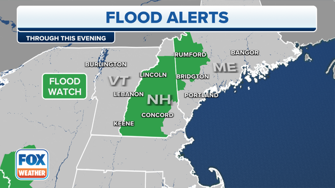
A Flood Watch is in effect for parts of New England on Tuesday, June 27, 2023.
(FOX Weather)
Farther south in the Northeast, a Flood Watch has been issued for parts of northern Delaware, eastern Pennsylvania, northern New Jersey and the western Catskills of New York.
Rainfall rates between 1 and 2 inches per hour are possible, which might result in flash flooding since the ground is already saturated after heavy rain on Monday.
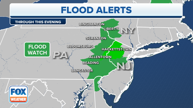
A Flood Watch is in effect for portions of the Northeast on Tuesday, June 27, 2023.
(FOX Weather)