Severe storms, including tornado threat, expected to return to Plains, Mississippi Valley through the weekend
Severe thunderstorms will likely become more widespread Friday afternoon into Friday night
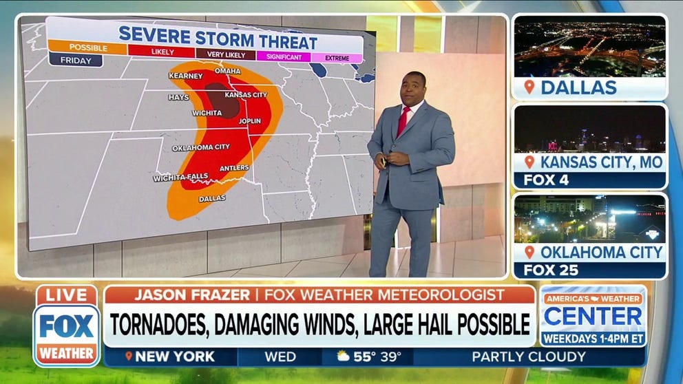
Tornadoes, damaging winds, large hail possible from late-week severe threat in Central US
The threat for severe storms returns Wednesday, peaks Friday, and may linger into the weekend.
Severe thunderstorms, including the threat of tornadoes, are expected to return to parts of the Plains and Mississippi Valley each day through the weekend and into the first week of May.
A southward dip in the jet stream will punch out of the Rockies and emerge over the central U.S. late this week, spawning another spring storm by Friday that will overlap with warm, humid air surging northward from the Gulf of Mexico.
Here is a day-by-day overview of what to expect from this latest severe weather threat.
HOW TO WATCH FOX WEATHER ON TV

Wednesday
Isolated strong to severe thunderstorms could produce damaging wind gusts and hail from eastern New Mexico and southeastern Colorado into the Texas and Oklahoma panhandles, western Kansas and south-central Nebraska late Wednesday afternoon and into the evening.
SOUTH MARKS 11 YEARS SINCE DEADLY TORNADO SUPER OUTBREAK

(FOX Weather)
Thursday
A severe thunderstorm or two might develop late Thursday afternoon or Thursday evening from northwestern Texas into western Oklahoma and central Kansas.
Any storms that are able to develop will be capable of producing large hail and damaging wind gusts.
WHAT YOU SHOULD DO TO PREPARE FOR TORNADOES

(FOX Weather)
Friday
Severe thunderstorms will likely become more widespread Friday afternoon into Friday night across portions of the Central and Southern Plains and the lower Missouri Valley, with the greatest risk of severe weather in parts of southeastern Nebraska and northeastern Kansas.
These storms will pose threats of large hail, damaging wind gusts and tornadoes in all the aforementioned areas.
TORNADO DROUGHT: KANSAS HAS ONLY ONE RECORDED STRONG TORNADO IN PAST 3 YEARS

(FOX Weather)
Saturday
The severe weather threat could continue farther eastward on Saturday in parts of the mid-Mississippi and lower Ohio valleys, including portions of eastern Missouri, southern Illinois, southwestern Indiana, western Kentucky, northwestern Tennessee and northeastern Arkansas.
Damaging wind gusts, large hail and a few tornadoes are all possible in these areas.
THIS IS HOW MANY TORNADOES EVERY STATE RECORDS IN AN AVERAGE YEAR

(FOX Weather)
Sunday
The threat of severe weather will shift back to West Texas for the first day of May, particularly in the South Plains and Concho Valley regions, as a new disturbance tracks eastward out of the southern Rockies.
Isolated severe thunderstorms capable of producing large hail and damaging gusts are possible Sunday afternoon and evening along a north-to-south oriented dryline.
WHAT IS A DRYLINE AND WHY IS ITS LOCATION IMPORTANT IN SEVERE WEATHER FORECASTING?

(FOX Weather)
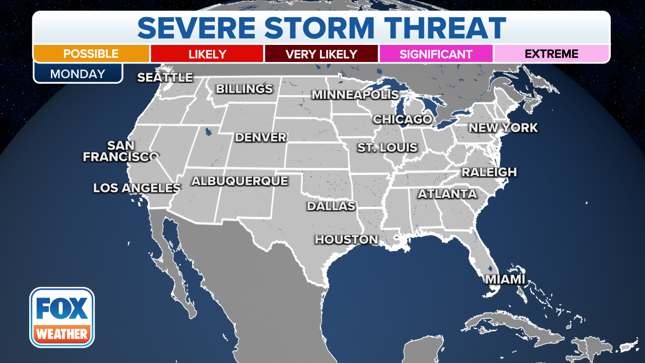
Monday
Severe thunderstorms are possible Monday in parts of North Texas, central and southern Oklahoma, southwestern Arkansas and northwestern Louisiana.
Damaging wind gusts, large hail and a few tornadoes are all possible in this region.
HERE'S WHERE TORNADOES ARE MOST LIKELY TO OCCUR IN EACH MONTH
(FOX Weather)
Flash flooding threat
Flash flooding is also a threat in portions of the Northern Plains and the mid-Mississippi and lower Missouri valleys through the weekend.
Between 1 and 3 inches of rain is predicted to fall across a broad area from North Dakota southeastward to eastern Kansas, Missouri and western Illinois through Saturday. Some spots could pick up more than 3 inches of rainfall, particularly where any storms slow down or stall over the same locations.

(FOX Weather)
The combination of locally heavy rain and melting snow in parts of North Dakota and northwestern Minnesota will likely exacerbate the ongoing river flooding in the Red River Valley of the North.
‘THE WATER WAS RISING RAPIDLY’: HEAVY RAINS TRIGGER RIVER FLOODING IN NORTH DAKOTA, MINNESOTA
Be sure to download the FOX Weather app for the latest forecast and weather alerts for your exact location, plus the 24/7 livestream of America's Weather Team.