Triple-threat Thursday: Severe storms, heavy snow, dangerous winds to impact US
The north side of the storm that will bring severe weather to the South will feature a mix of snow, ice, heavy rain and high winds. This will be the result of a strengthening area of low pressure moving across the eastern U.S.
Severe storms, heavy snow, dangerous winds to impact US
The same storm system will be responsible for three major impacts on Thursday.
It's a triple-threat Thursday across the U.S. One storm system will be responsible for three major impacts from severe storms to rain and high winds to snow.
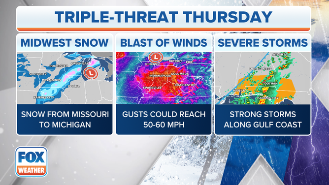
The same storm system will be responsible for three major impacts on Thursday.
(FOX Weather)
Severe storms eye Gulf Coast, Ohio Valley
The FOX Forecast Center is monitoring two areas with a threat of severe thunderstorms on Thursday: the Gulf Coast and the Ohio Valley.
Thursday's severe weather threat is associated with the same system that spawned damaging storms from Texas to Missouri on Wednesday. Hardest hit appeared to be Tangipahoa Parish in Louisiana, where authorities said they rescued children who had been caught in a trailer that was overturned and destroyed during a suspected tornado.
CHILDREN FOUND IN OVERTURNED TRAILER AFTER TORNADO RIPS THROUGH LOUISIANA

(FOX Weather)
The threat of severe storms is much lower Thursday, but as the day progresses and temperatures rise, modest instability is forecast to develop across southern Alabama, southwestern Georgia and the Florida Panhandle.
Thunderstorms will strengthen accordingly, and a few storms could become severe. The FOX Forecast Center said wind shear – the change in wind speed and/or direction with height – will continue to weaken, but it should still remain sufficient for a few severe thunderstorms capable of locally damaging wind gusts and a brief tornado.
In the Ohio Valley, Thursday's storms could produce isolated damaging wind gusts across parts of Indiana, Ohio and southern Lower Michigan.
The severe weather threat in both regions will end after the sun sets Thursday evening.
Rain, high winds blast Midwest
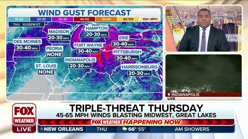
In addition to the threat of severe storms, wind energy in the atmosphere will be in abundance across the Midwest, even outside of any thunderstorms. As a result, winds will gust to 45-plus mph over a wide area.
This comes in response to a sharp change in pressure between a strengthening low-pressure system across the Midwest and a strong high-pressure system over the Rockies.
The FOX Forecast Center said a line of rain showers will form along or ahead of the storm system's cold front from eastern Illinois into Indiana, then spread into parts of Ohio and Lower Michigan.
Central and southern portions of Lower Michigan will likely see the most rain, with up to 2 inches possible.
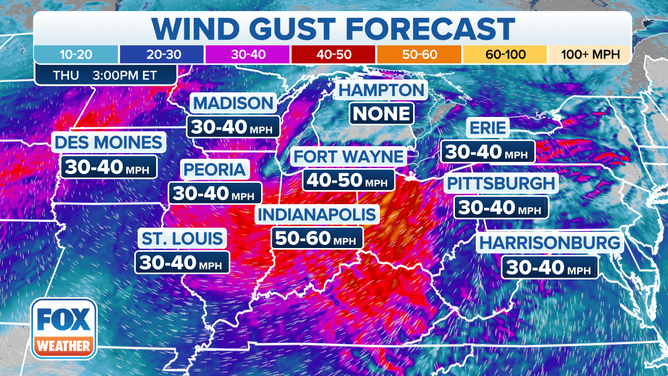
Wind energy in the atmosphere will be in abundance across the Midwest, even outside of any thunderstorms. As a result, winds will gust to 45-plus mph over a wide area.
(FOX Weather)
Although the rain showers aren't expected to produce much lightning, they will locally enhance the winds to damaging levels of 60-plus mph in some areas.
The damaging-wind threat should end by Thursday evening as the rain showers move north into Canada, the FOX Forecast Center said. However, even after the showers move out of the country, gusty winds will continue into Thursday night.
More than 60 million people across over a dozen states are under High Wind Warnings or Wind Advisories on Thursday.
BATTEN DOWN THE HATCHES: WHAT YOU SHOULD KNOW ABOUT HIGH WIND WARNINGS

(FOX Weather)
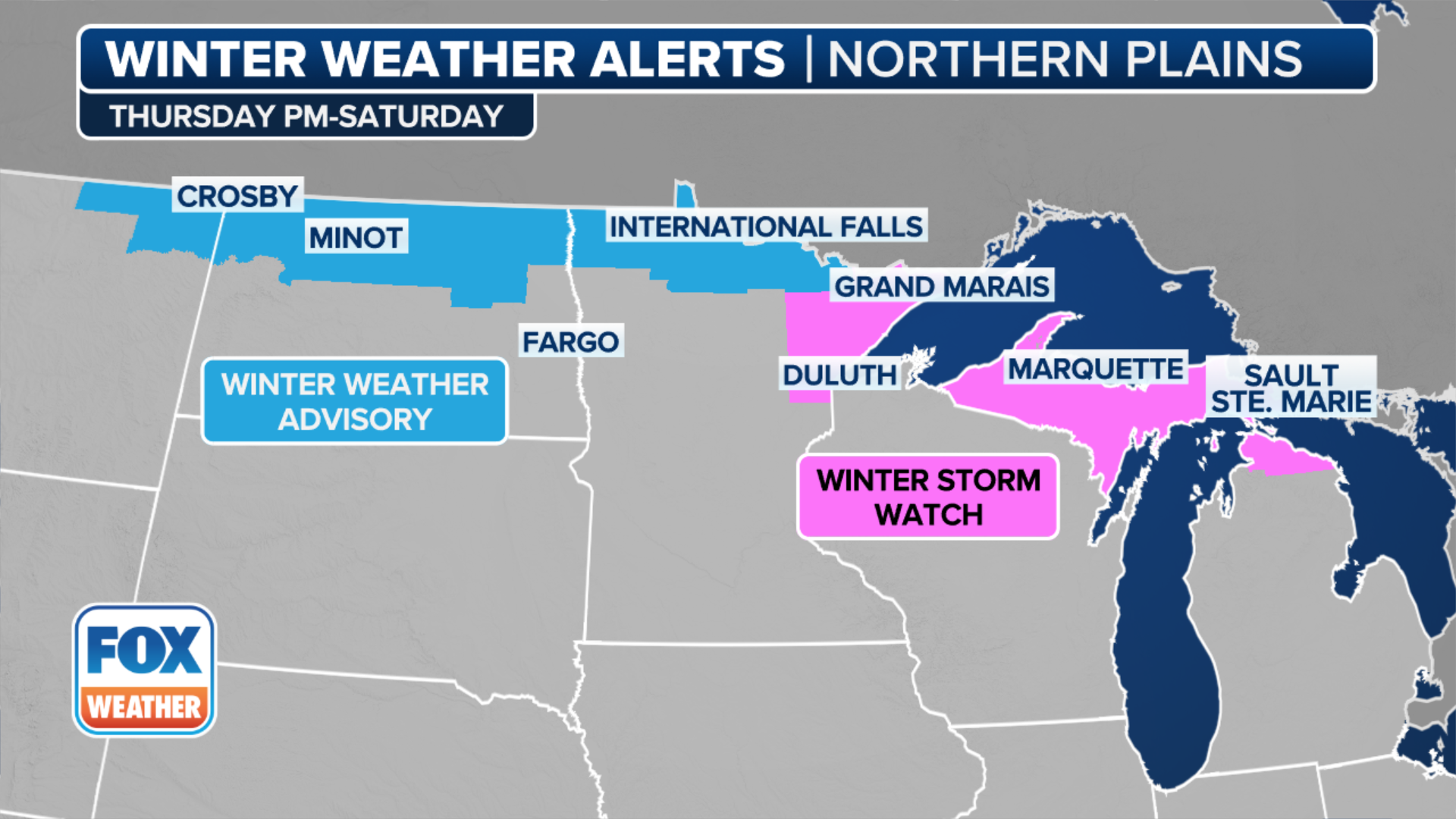
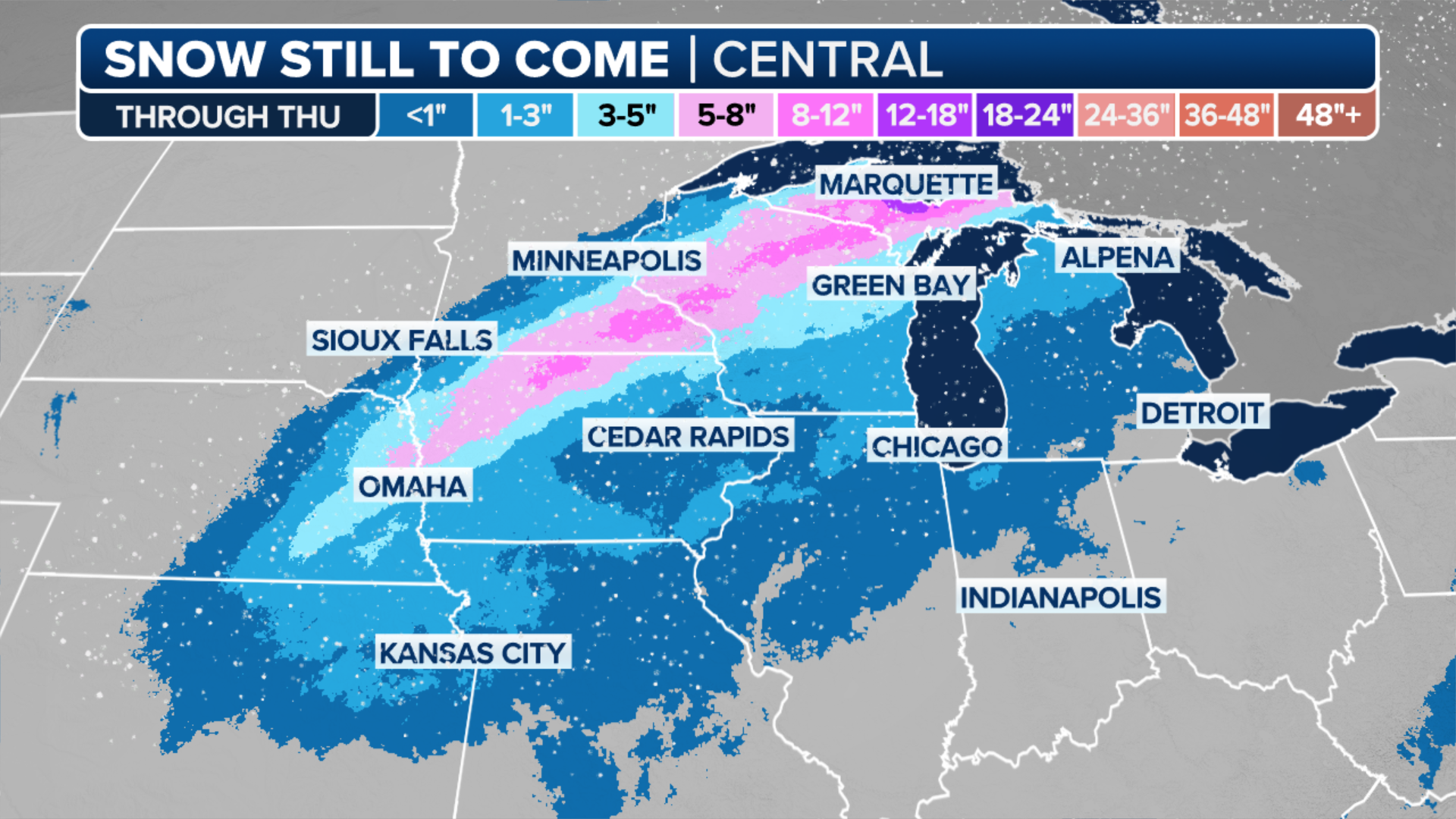
Snow comes to Upper Midwest as low pressure tracks into Great Lakes
Snow quickly developed across portions of the upper and mid-Mississippi Valley on Thursday morning.
The FOX Forecast Center said thundersnow was reported shortly before 2:30 a.m. CST in Kansas City, Missouri, as large, wet snowflakes fall across the metro area. Prior to that, snow blanketed parts of central Oklahoma, including Oklahoma City, Wednesday evening. Up to 2.5 inches fell just northwest of the city.
Snow will intensify Thursday morning across Iowa and Wisconsin, where snowfall rates between 1 and 2 inches per hour are possible. This is expected to have an impact on the morning commute in cities such as Davenport and Cedar Rapids in Iowa and Madison in Wisconsin.
The snow will end across Iowa Thursday afternoon while continuing into Thursday evening across Wisconsin and the Upper Peninsula of Michigan.
(FOX Weather)
Travel delays due to slippery, snow-covered roads are possible across interstates in Wisconsin, especially Interstate 94.
By the time snow tapers off, between 3 and 8 inches will pile up from eastern Iowa to central Wisconsin and northern Lower Michigan, with lesser amounts across western Iowa, southern Minnesota and the Upper Peninsula of Michigan.
(FOX Weather)
Minneapolis and Milwaukee will see measurable, but not significant, amounts of snow from this storm.
To the east, across northern Lower Michigan, a period of freezing rain may lead to a few hours of very hazardous travel Thursday morning before temperatures warm above freezing.
At the same time, this low-pressure system will send a warm front into New England, the FOX Forecast Center said. This front will be the focus for widespread precipitation across the Northeast.
While much of that precipitation will fall as rain, there will be a window for a few hours of snow and freezing rain Thursday morning across the Catskills and Adirondacks of upstate New York and the northern New England mountains.