Millions across Central US in the path of another round of severe weather and potential flash flooding
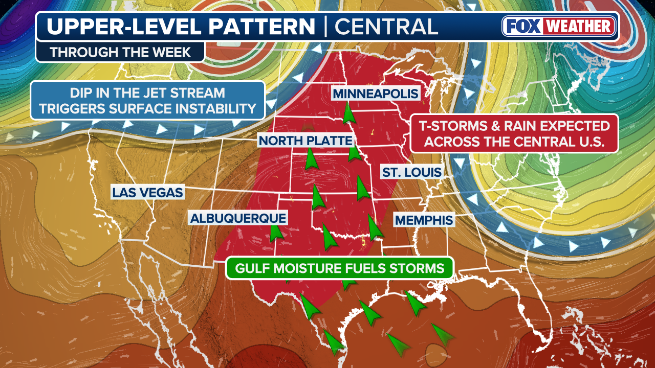
These storms will also tap into widespread Gulf moisture across the middle of the country, creating a flash flood threat that stretches from West Texas to southern Minnesota.

Severe storms recharge across the Northern Plains as Gulf moisture fuels a Central US flood threat
Severe storms are targeting millions of people Thursday afternoon across parts of the Northern Plains and Central U.S. for the third consecutive day.
Millions are in the path of severe thunderstorms beginning Thursday afternoon across parts of the Northern Plains and Central U.S. as the region faces a third consecutive day of severe weather. These storms will also tap into widespread Gulf moisture across the middle of the country, creating a flash flood threat that stretches from West Texas to southern Minnesota.
SLOW-MOVING SYSTEM TO BRING TROPICAL DOWNPOURS, ROUGH SURF AND STRONG WINDS TO THE GULF COAST

Watch: Cars create wakes in Katy, Texas, neighborhood as thunderstorms trigger flash flooding
Cars create wakes in Katy, Texas, neighborhood as thunderstorms trigger flash flooding.
This is the latest in a week-long pattern where a dip in the jet stream, combined with 90-degree temperatures and Gulf moisture, will trigger storms capable of producing both severe weather and flooding rain.
Cars created wakes in a Katy, Texas, neighborhood as thunderstorms triggered flash flooding Wednesday.
This same pattern also brought a hailstorm to downtown Denver on Monday.
On Thursday, another storm system will move eastward out of southern Canada and into the Northwest, after supercell thunderstorms formed over Montana and the Dakotas earlier in the week.
WHAT IS A SUPERCELL THUNDERSTORM?
A Level 2 out of 5 risk of severe thunderstorms covers parts of southeastern Montana, northeastern Wyoming, much of South Dakota, as well as northern Nebraska and eastern Minnesota beginning Thursday.
Large hail and damaging wind gusts are expected to be the primary hazards.

(FOX Weather)
A broad Level 1 threat covers much of the Heartland, including Nebraska, as well as parts of Kansas and Oklahoma.
A Level 2 out of 4 flash flood threat is centered on central Iowa, southeastern Nebraska and northeastern Kansas, as storms tap into widespread Gulf moisture.

Watch: Large supercell looms over Alzada, Montana amid severe thunderstorm warnings
Amazing drone footage from FOX Weather Exclusive Storm Tracker Mark Sudduth captures a supercell looming near Alzada, Montana. The NWS placed southern Carter County under a severe thunderstorm warning on Tuesday as the storm rolled through.
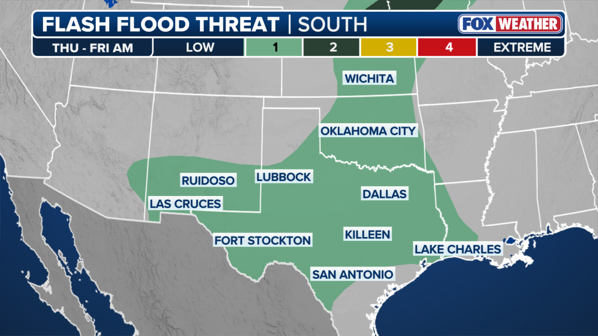
Farther south, clusters of storms associated with a weak dip in the jet stream will drive a flash flood threat across western Texas and New Mexico.
According to the FOX Forecast Center, a Level 1 flash flood risk is in place for southeastern New Mexico and western Texas, including Ruidoso, New Mexico, where wildfire burn scars continue to increase flood vulnerability.
(FOX Weather)
Despite the potential for flooding, heavy rain will help ease Extreme Drought conditions in the Texas and Oklahoma Panhandles, as well as other parts of the Southern and Central Plains.
(FOX Weather)
Gulf moisture will help produce heavy downpours, leading to flash flood threats where slow-moving thunderstorms develop.
Through the start of the weekend, 1 to 2 inches of rain are possible in areas such as Midland and Amarillo, Texas, as well as parts of the eastern Dakotas and western Minnesota.
Stay with FOX Weather for the latest on the storms.