Saharan dust plume seen from space dominates Florida skies
Saharan dust can cause air quality concerns because of the size of its particles. The dust also creates vibrant sunrises and sunsets because of the way light reflects on those particles.

Second Saharan dust plume arrived in Florida late this week
Saharan dust is being carried across the Atlantic to the Florida skies and, eventually, as far as Texas. Storms kick up dust in Africa sending it on its way to the U.S. mainland. The dust creates colorful sunrises and sunsets.
Upper-level winds have carried the first plume of Saharan dust across the Atlantic Ocean this week, filling Florida's sky with particles that create beautiful sunsets and sunrises.
Every year between June and August, the Saharan Air Layer is created when African storms kick up layers of dust that are carried 5,000 miles across the Atlantic, reaching Florida's coast and even as far as Texas. Each year about 100 million tons of dust from the Saharan Desert are transported across the Atlantic, according to NOAA.
The FOX Forecast Center is tracking another dust plume set to arrive in the mainland U.S. late Wednesday.
"By Wednesday, we're going to start seeing this moving across the Florida Keys and then by Thursday, I think we'll start seeing this in Fort Myers as well as the Orlando area," FOX Weather Meteorologist Jason Frazer said.

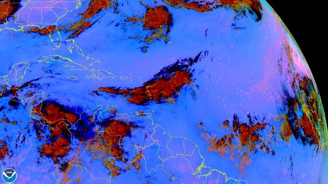
The Saharan Air Layer or Saharan dust is seen in this GOES-16 satellite image moving across the Atlantic. (Image: NOAA)
(NOAA)
Several NOAA satellites are used to track the dust, including the GOES satellites, NOAA-20 and the NOAA/NASA Suomi-NPP.
The GOES-16, or GOES-East, satellite image above shows the subsequent Saharan dust plume over the central Atlantic Ocean being carried by brisk upper-level winds toward the U.S. and Caribbean islands.
The plume is a swath of pink in the satellite imagery below posted by the National Hurricane Center's Tropical Analysis and Forecast Branch.
GOES-16 also monitors dust particles between 5 and 9 miles up in the atmosphere. The dust can be seen in pink below.
In this GOES-16 satellite image, dust appears pink.
(NOAA)
Dust can cause air quality concerns
Saharan dust can cause air quality concerns because of the size of its particles. The dust also creates vibrant sunrises and sunsets because of how light reflects on those particles.
The sky has been incredibly hazy in South Florida since Sunday when the first dust plume reached Florida's coast.
The National Weather Service office in Miami shared a view of the dust creating a haze around the sun as forecasters launched the weather balloon on Monday evening.
Forecasters also track the Saharan dust because of its impact on the tropics.
Dry air hinders tropical storm development by sucking up all the moisture needed to fuel storms.
"The good news is that the more Saharan dust we have in the upper levels, the less development we have in the tropical Atlantic," Fraser said.