Bryan Norcross: Saharan dust dominates the tropics while a system starts spinning to the north
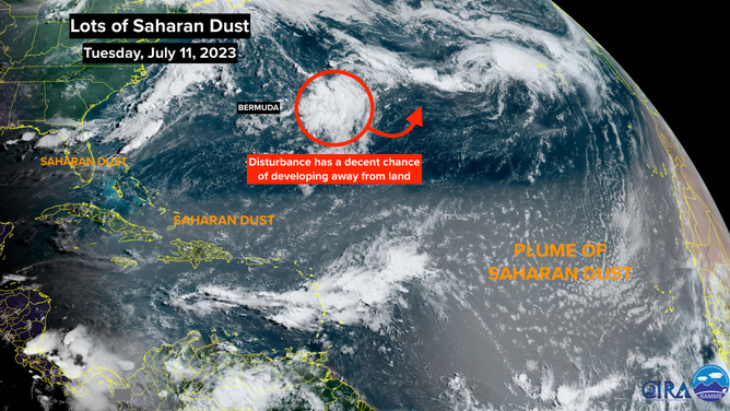
In the middle of the Atlantic, a non-tropical area of disturbed weather has a decent chance of becoming tropical enough to get a name late this week. Computer forecasts call for it to drift over the warm ocean long enough to become at least somewhat tropical for a few days before it heads north over cooler waters.

Generic Hurricane HQ
(FOX Weather)
Updated Tuesday at 8:45 a.m. EDT
The most far-reach plume of Saharan dust this hurricane season is stretching all the way across the Atlantic. The dry tongue of dusty air has reached Florida and the Gulf of Mexico. The effect on land areas is to suppress thunderstorms by sponging the moisture out of the middle of the atmosphere. In addition, the lack of cloudiness and rain adds another ingredient to the atmospheric pattern that has created the oppressive heat Floridians have experienced this summer.
For much of the summer, low pressure has been parked over the East Coast of the U.S. This has caused weeks of heavy thunderstorms across the South and torrential rain in the Northeast, among other effects. In addition, it has weakened the Bermuda High, which has meant lighter breezes across Florida and the surrounding waters.
Saharan dust seen via NOAA satellites.
(NOAA)
Lighter winds mean the waters are not stirred and mixed by the wave action on the surface. The stiller water heats up under the intense Florida sun. In the last couple of days, we’ve seen stunning water temperatures of 95 degrees and 97 degrees at sensors in the middle Florida Keys and Florida Bay. In Miami, Biscayne Bay is running above 90 degrees during the day.
Higher water temperatures mean a warmer, moister atmosphere. This means more humidity in the air, which makes it feel even hotter, and heavier thunderstorms forming in the heat of the day if nothing intervenes like a plume of Saharan dust.
The current plume of Saharan dust should fizzle over Florida and the Gulf in a day or two, but it will continue over the tropics, keeping things quiet.
In the middle of the Atlantic, a non-tropical area of disturbed weather has a decent chance of becoming tropical enough to get a name late this week. Computer forecasts call for it to drift over the warm ocean long enough to become at least somewhat tropical for a few days before it heads north over cooler waters.
If the National Hurricane Center determines that the top winds in the circulation have reached 40 mph, it will be named Don. The system doesn’t look like a threat to land.
Saharan dust and hostile upper winds are forecast to cover the tropical waters for the next week at least, so no threatening systems are expected to develop.