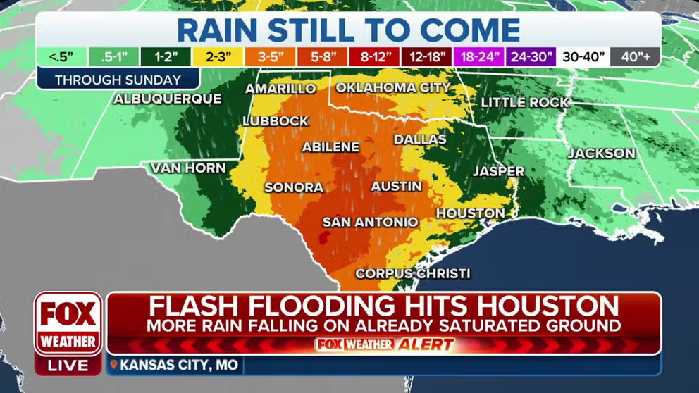
Houston faces risk of more flash flooding as rounds of rain soak up to 40 states
An exceptionally wet stretch of days is expected across the central U.S. as three upper-level disturbances bring rounds of rain. Several inches of rainfall will soak areas from the northern Rockies through the Rio Grande Valley of Texas.
Flash flooding event ongoing in Houston, Texas
FOX Weather meteorologist Stephen Morgan was live in Houston and said the city was getting more rain than it could handle Tuesday. A Flood Watch is in effect for Houston through Wednesday afternoon.
HOUSTON – Round after round of rain has pounded parts of the country this week as several quick storms make their way across America, and the parade is not over yet. Forty states in the Lower 48 are in for widespread rain and thunderstorms into the weekend.
On Tuesday, the first of three upper-level chunks of energy stirred up storms in the Houston area. One neighborhood got 4 inches of rain during the thunderstorms, according to the Harris County Flood Warning System. For a while, parts of the city were under a Flash Flood Warning.
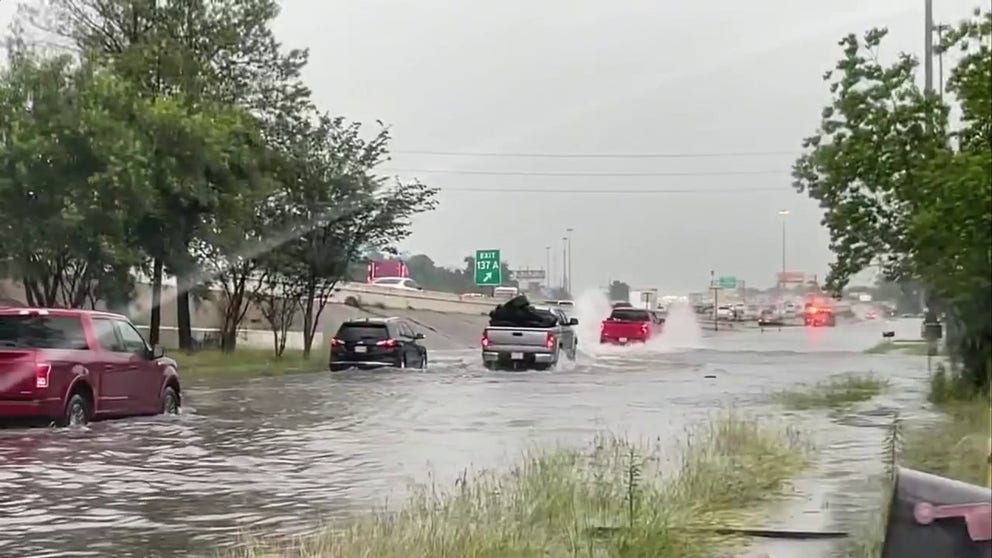
Heavy rain from these thunderstorms caught several drivers in Houston off guard. Some roads that feed into major highways through the city were filled with water, making them look more like rivers with cars and trucks swimming upstream. Fire crews were busy with water rescues of drivers in cars that were close to floating.
EXPLAINING FLOOD ALERTS ISSUED BY THE NWS
Cars swim through Houston during flash floods
Cars entering and exiting the highways have stalled on the side of the road due to the amount of flooding in Houston. Some trucks and larger vehicles were able to pass through as others remained on the street.
Roads are designed to be part of Houston's flood control system, collecting the excess water and sending it into drainage systems which eventually empty into the Gulf of Mexico.
No water has entered homes.
Even though Tuesday's rain tapered off, a second round of storms and heavy rain is expected in the Houston area by Wednesday morning. A Flood Watch is in effect for much of Southeast Texas through Wednesday evening.
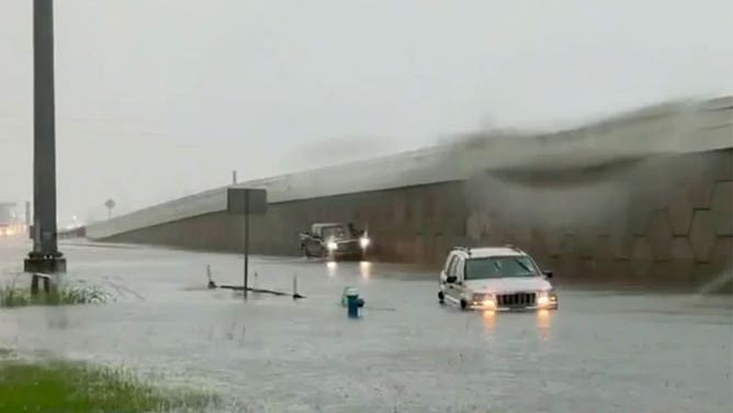
Vehicles attempt to navigate a flooded road in Houston on May 9, 2023.
(FOX 26 Houston)
IT'S NOT THE HEAT; IT'S THE HUMIDITY: MOISTURE INCREASES HEAT RISK
"This is classic Gulf Coast humidity," said FOX Weather meteorologist Stephen Morgan, reporting from Houston. "It's what so many people say, a truly, ‘Air that you can wear.’"
High temperatures are in the high 70s, while dew points are in the mid-70s.
"And that's going to be one of the culprits for us seeing the rain on Wednesday and into Thursday," he added. "We've had it today, and we're going to have it tomorrow in the Houston area. This is the ‘moderate’ or ‘very likely’ threat, level 3 out of 4, that we have as far as seeing the heavy rain. It's not going to take much to flood some of these areas."

Rain pounds Houston, dangerous driving conditions
Intense rain led to floodwaters and dangerous travel conditions in Houston, Texas on Tuesday. FOX Weather correspondent Robert Ray showed waters rushing along the banks of the Buffalo Bayou.
The heavy rains have already led to one death. North of Houston, the saturated ground couldn't hold the supporting roots of a tree on Monday. It fell on a car crushing a woman during heavy rain even before the upper-level disturbance came through.
1 KILLED IN SOUTHEASTERN TEXAS AFTER TREE FALLS ON VEHICLE DURING STORM
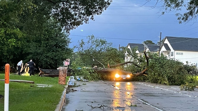
Photo of a fallen tree on motorist at East Cypresswood and Whitewood in Harris County, Texas.
(FOX 26 Houston)
New Orleans deluge
Texas is not alone. The NWS issued Flood watches and warnings across several states.
New Orleans fire department crews were also busy, deep water trapped drivers on a low lying road. And, the Canal Boulevard underpass took its name too literally.
![]() Image 1 of 2
Image 1 of 2Road flooding trapped this driver. (New Orleans Fire Department/Facebook)
![]() Image 2 of 2
Image 2 of 2The flooded Canal Boulevard underpass in New Orleans. (@ChrisMalkove/Twitter)


Rain stretches into the weekend
The most widespread showers and thunderstorms will set up across the Plains, where the FOX Forecast Center expects widespread 1-3-plus inches of rain this week. Between 3 and 5 inches of rain could fall in portions of Texas, Oklahoma, South Dakota, northeastern Wyoming and southeastern Montana.

(FOX Weather)
Most of the eastern U.S. will get off easier and see only remnants of each storm system. Less than an inch of rain is expected in most of the region, with the interior Northeast and New England largely escaping the rainfall this week.

(FOX Weather)
Wednesday
The heavy rain spreads north and heads for east Texas, Oklahoma and Arkansas too. The FOX Forecast Center said that the strongest of storms could drop another 2-6 inches of rain.
More showers and thunderstorms are expected from the Plains to the lower Mississippi Valley and parts of the Southeast. Storms will be more scattered than in other areas of the country but could drop 1 to 2 inches of rain.
7 FACTS YOU SHOULD KNOW ABOUT FLASH FLOODS

(FOX Weather)
Thursday
The second upper-level chunk of energy moves out of the Rockies on Thursday. It will encounter the steady stream of Gulf moisture and "air you can wear."
"The result will be significant heavy rain across the Northern Plains and Rockies," said the FOX Forecast Center. "Flooding is likely as some areas pick up a months worth of rain in just 2 or 3 days."
Some areas could see 3 to 5 inches of rain in just 24 hours.
The highest threat of flash flooding will be focused across portions of eastern Montana, eastern Wyoming, the western Dakotas and western Nebraska.
The National Weather Service has issued Flood Watches for eastern Montana and parts of northeastern Wyoming from Wednesday evening through late Friday night.

(FOX Weather
Friday
The final disturbance will park itself over the Southwest and Mexico starting Friday and continuing through the weekend.
The FOX Forecast Center said deep moisture from the Gulf of Mexico will be pulled north into the southern Plains, and there is a strong signal for potentially significant rainfall of several inches – on top of what has already fallen by then.
Multiple rounds of moderate to locally heavy rain are increasingly likely, raising concerns for additional flash flooding given increasingly saturated ground conditions.
HOW TO WATCH FOX WEATHER ON TV

(FOX Weather)
Saturday
The disturbance is a slow-mover, keeping the chance for heavy rain and flooding into Saturday.
Austin and San Antonio are very likely to see flooding thunderstorms. A likely flood threat extends across much of the state and into central Oklahoma.
Flooding is also possible across the Midwest from Minneapolis to Chicago.

(FOX Weather)
Keep watching FOX Weather on TV or check in with the app and FOXWeather.com for forecast updates and exact timing for the weather in your city.