Potentially life-threatening flooding setup puts millions on alert from Plains to Deep South
It’s an active weather pattern that the FOX Forecast Center said would remain in place across the region through the rest of the workweek and into the Labor Day holiday weekend.
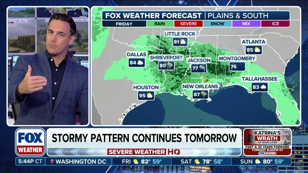
Stormy pattern continues into south for Labor Day weekend
Storms are leaving the Plains and heading into the South as Labor Day weekend approaches. The storms are expected to bring heavy rains and the possibility of flash flooding for parts of Texas, Louisiana and Alabama into Friday afternoon.
LITTLE ROCK, Ark. – Rounds of torrential rain and thunderstorms from the Plains to the Deep South are leading to a potentially dangerous setup that could produce life-threatening flash flooding over the next few days.
It’s an active weather pattern that the FOX Forecast Center said would remain in place across the region through the rest of the workweek and into the Labor Day holiday weekend.

(FOX Weather)
Flooding rain and thunderstorms pushed through communities from the central Plains to the Deep South early Thursday morning, with Flash Flood Warnings issued in parts of Kansas.
According to local storm reports received by the National Weather Service, numerous damaging wind gusts were reported in areas such as Johnson City, Kendall and Moscow in Kansas on Wednesday afternoon and evening, and flood reports were received in Colby, Kansas, early Thursday morning.
Travel in Kansas was also impacted as the morning commute got underway. According to the Kansas Department of Transportation, portions of Interstate 35 were temporarily closed due to flooding.

Flash flooding slams Arkansas amid rounds of rain
Water is washing out parts of Fayetteville, Arkansas with flash flooding. The city says the fire department has already made several water rescues. The latest on the flash flood threat:
Officials in Fayetteville, Arkansas, warned residents of the potentially dangerous and life-threatening flooding in the area on Thursday. Officials urged residents to avoid travel if possible, and to avoid flood-covered roadways.
Officials said there were numerous reports of vehicles stranded in floodwaters, resulting in water rescues.
DOWNLOAD THE FREE FOX WEATHER APP
The FOX Forecast Center said that with abundant instability in the atmosphere, intense thunderstorms with rainfall rates of up to a staggering 3 inches per hour are possible, especially along and near a warm front that’s draped across the region.
Flood Watches remain posted in parts of Kansas, northern Oklahoma and northwestern Arkansas.
By Friday and into the Labor Day holiday weekend, a frontal boundary is expected to stretch from the Front Range in Colorado to Florida, with waves of low pressure riding along it, sparking numerous showers and thunderstorms.
And with plenty of atmospheric moisture in place, a localized flood threat will exist across much of the South.

Watch: Heavy rain and storms soak Oklahoma
Video from Thursday showed heavy downpours from storms making for a rough commute in Edmond.