Pineapple Express heads for California with flooding, wind, snow starting Wednesday
The Pacific Northwest already endured two atmospheric rivers over the past week while California got a break. The break is short-lived as the strongest atmospheric river, with a tropical connection from Hawaii, pushes south and even into the Desert Southwest.
Atmospheric river to blast California starting Wednesday
Preparations are underway in California for an atmospheric river storm that’s expected to bring heavy rain and damaging wind gusts that could lead to flooding, landslides and mudslides.
All aboard the Pineapple Express this week in California as some coastal ranges could see over 8 inches of rain before the end of the week, while Los Angeles and San Diego could be in for more monumental flooding.
The Pineapple Express is an atmospheric river that sets up a fire hose of moisture starting near Hawaii and blasts the West Coast. That atmospheric river can carry up to 27 times the amount of water carried by the Mississippi River, which is the equivalent of up to 10-15 inches of rain.
WOMAN SURVIVES ON HER OVERTURNED CAR FOR 15 HOURS IN CALIFORNIA FLOODS
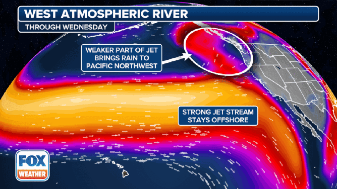
The atmospheric river rides the jet stream to soak the Pacific Northwest early this week, then shifts south through late-week.
(FOX Weather)
"What we've got going now is a very active period when the upper-level jet is stretching across the Pacific," Marty Ralph, director of the Center for Western Weather and Water Extremes, told FOX Weather on Monday. "There's a lot of moisture being transported in a series of atmospheric river storms associated with that. And they're sort of stalled a bit over the Northwest for a few days here. And soon they're going to move down the coast along into California."
Significant impacts:
Moisture from the Pineapple Express will branch north and soak Washington and Oregon. The system is warm, so forecasters in the area don't expect snow. The National Weather Service in Seattle calls for the possibility of record warmth through Tuesday.
Any rain will add to the already-saturated ground the area has previously seen, so river levels will be on the rise, and some flooding is possible, along with a landslide risk.
LANDSLIDE THREAT HALTS TRAIN SERVICE BETWEEN LOS ANGELES AND SAN DIEGO
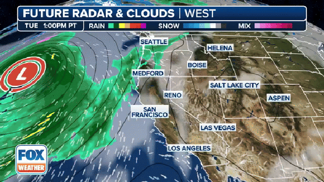
The atmospheric river, nicknamed the Pineapple Express, makes landfall Wednesday in California, drenching San Francisco through San Diego.
(FOX Weather)
"The good news here is it's going to be strong, it's going to be heavy at times, but it's going to be transient – it's going to be moving pretty quickly," FOX Weather Meteorologist Bob Van Dillen said. "So it's not going to be at the same spot for a long period."
SEE SOME OF THE MOST CATASTROPHIC ATMOSPHERIC RIVERS AND FLOODING IN CALIFORNIA HISTORY
![Forecast rain totals.]() Image 1 of 2
Image 1 of 2Forecast rain totals. (FOX Weather)
![Forecast snow totals.]() Image 2 of 2
Image 2 of 2Forecast snow totals. (FOX Weather)

"But even with that, look how much rain we're looking at across Northern California, essentially starting on Wednesday," he continued. "That orange-shaded area is 3 to 5 inches of rain (in the Bay Area). In Northern California … it's about 5 to 8 inches of rain."
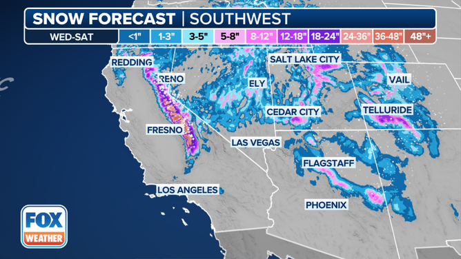
Above pass level, the Sierra Nevada could see 1-3 feet of new snow.
Timing:
Wednesday

(FOX Weather)
"Wednesday morning into Wednesday afternoon, the rain starts stretching through the northern sections of California, and higher elevations get a little bit of snowfall," Van Dillen said.
Flash flooding is likely from southwestern Oregon southward through Eureka, Ukiah, San Francisco and Monterey in California.
"Shallow soils on steep hillslopes are approaching saturation," wrote the San Francisco NWS office in an advisory. "This coupled with the forecasted precipitation means widespread shallow landslides are likely."
(FOX Weather)
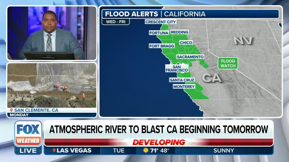
Flood Watches have been posted in advance of the atmospheric river, stretching along the California coast from the Oregon border to the south of the San Francisco Bay Area.
The Flood Watches also extend inland and include cities such as Chico, Sacramento and Redding.

(FOX Weather)
Wind Advisories, High Wind Watches and High Wind Warnings were issued across the region.
Wind Advisories were issued for places like Chico, Sacramento, San Francisco, Monterey and King City for wind gusts up to around 60 mph.
The High Wind Warnings were issued in Northern California and portions of southern Oregon for the potential of wind gusts up to 75 mph.
"Damaging winds could blow down trees and power lines," the NWS warned. "Widespread power outages are possible. Travel could be difficult, especially for high-profile vehicles."
Thursday

(FOX Weather)
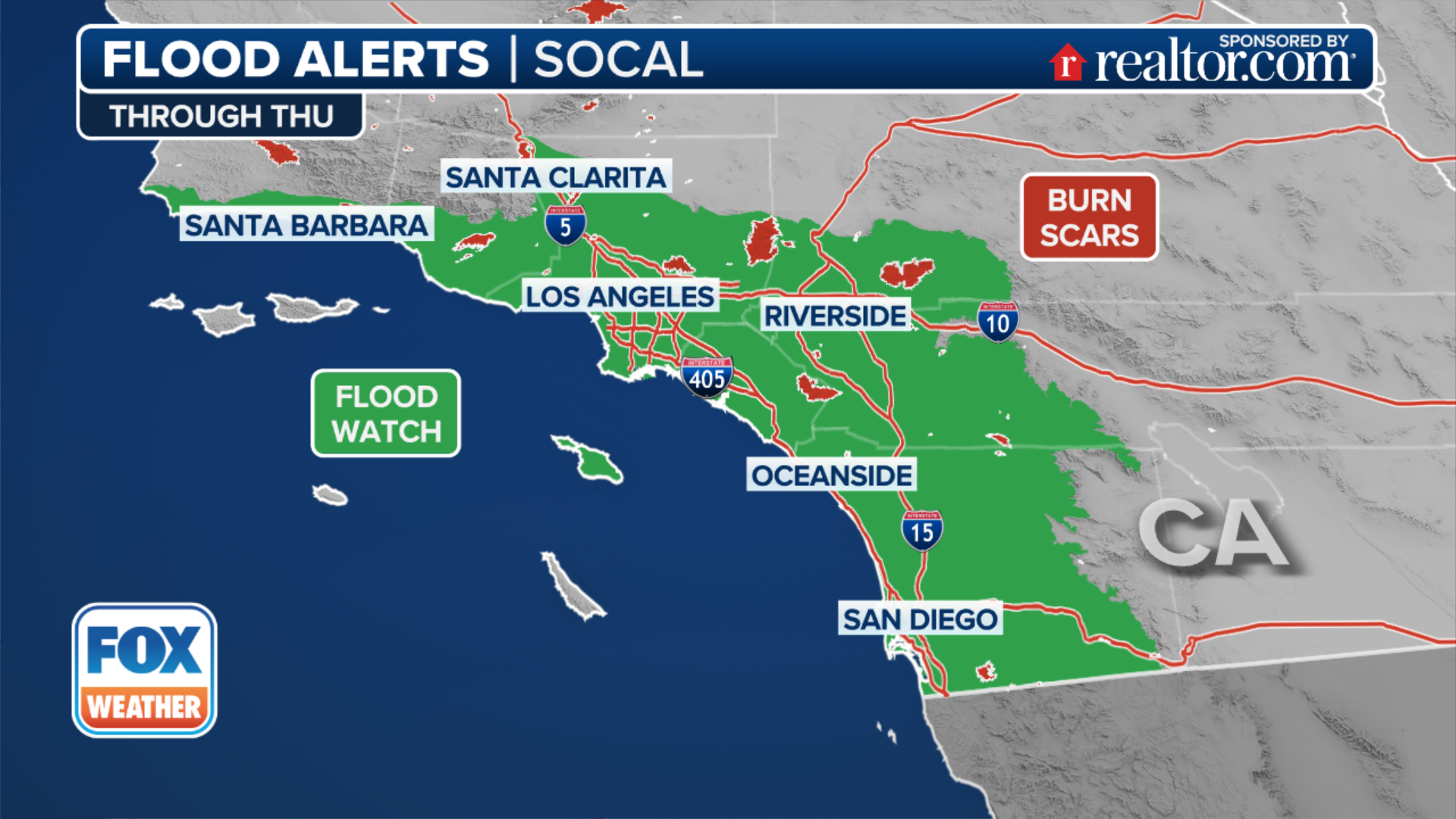
The flash flood threat shifts farther south on Thursday.
The NWS said flash flooding is likely from the Santa Barbara area southward through Santa Clarita, San Bernardino, Los Angeles, Temecula, Escondido and San Diego.
Friday to Monday
The heaviest rain moves through Los Angeles and San Diego counties by late Thursday. Showers will continue on Friday. The rain then makes its way through Arizona and even New Mexico into the weekend.

(FOX Weather)
"The Climate Prediction Center (CPC) has already indicated a moderate risk for heavy precipitation, heavy snow and high winds for regions in the western U.S. and possible flooding along the California coast and in Arizona for Feb. 2 through Feb. 5," wrote the Center for Western Weather and Water Extremes.
"Snow, it's coming in, and that could be pretty decent for higher elevations, Sierra Nevada range all the way through the Four Corners and northern Nevada," Van Dillen said.