Parade of atmospheric river storms soaking Pacific Northwest with flooding rain, feet of mountain snow
Multiple storms will soak the Pacific Northwest into next week, with the potential for a "Pineapple Express"-type atmospheric river storm looming to bring an additional several inches of rain early next week, triggering flooding concerns along the region's rivers.
Atmospheric river event to unleash heavy rain and mountain snow across Northwest
Flooding rain and heavy snow is expected to make travel difficult through the next week. More than 10 million people are under weather alerts ahead of the arrival of the next storm system.
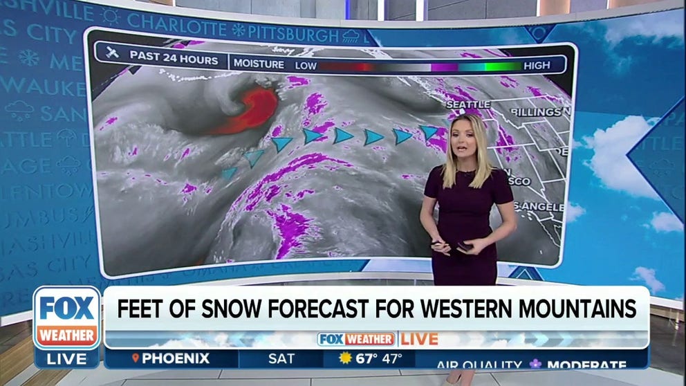
SEATTLE – A series of atmospheric river storms has put the Pacific Northwest in the middle of its soggy bullseye, dropping several additional inches of rain and threatening moderate to possibly even major flooding on multiple rivers.
The region experienced a soaking storm to start the weekend, with several inches of snow in the Cascades, including over a foot at Mt. Rainier's Paradise Ranger Station.
On Friday, Interstate 90 through Snoqualmie Pass, near Seattle, was closed for an hour after 30 semi-trucks spun out on snow-covered roads. The Washington State Department of Transportation reported that road crews were busy clearing other accidents that occurred along slick highways.
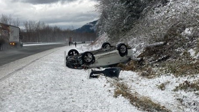
A car overturns on a slick highway during a storm in Washington on Dec. 1, 2023.
(Washington State Dept. of Transportation)
Snowfall also extended into Eastern Oregon and Washington, where a few inches covered the ground.
One person was killed in a crash in rural Stevens County in northeastern Washington after the driver lost control on a snow-covered road and struck a tree, according to the Washington State Patrol. Troopers reported 25 crashes due to slick roads in Central and Eastern Washington, including more than a dozen in the Tri-Cities area.
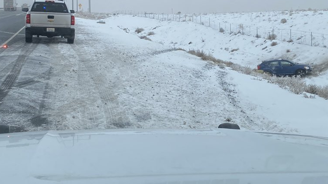
A car spins out on Interstate 90 in Central Washington on Dec. 1, 2023.
(Washington State Patrol)
More snow Saturday before snow levels rise rapidly
Stormy weather with additional rain and mountain snow is forecast to linger in the mountains into Sunday.
Winter Storm Warnings remain in effect through Sunday, stretching along the entire spine of the Cascades in Washington and Oregon, including all the heavily traveled mountain passes near the Seattle and Portland areas, for total storm snow accumulations of 1-3 feet.

(FOX Weather)
The heavy snow threat will also extend well east into the mountains of the Great Basin and Rockies as Pacific moisture spilling out of the Pacific Northwest reaches the windward slopes of the Intermountain Region, according to the FOX Forecast Center.
The higher terrain of Idaho, western Montana, northern Utah, northwest Wyoming and northwest Colorado will see as much as 1 to 3 feet of snow locally by early Monday, and various winter weather alerts cover the region.

(FOX Weather)
In addition, gusty winds of 35-50 mph will cause blowing snow in the mountains and power issues in the lowlands. About 16,000 people lost power in Western Washington on Saturday morning – including 13,000 in the Seattle Metro area but outages were quickly restored by the evening.
"For many of you that have kids going to university on the other side of the state, this is not going to be the weekend for them to travel home," FOX Weather Meteorologist Britta Merwin warned. "You’re going to want to tell them to just stay there and have a weekend with your friends instead of heading back home."
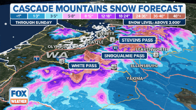
Snow forecast in Cascade Mountains through Sunday.
(FOX Weather)
Atmospheric rivers ramp up next week with ‘Pineapple Express’ possible
The pattern shifts during the second half of the weekend from a mountain snow threat to a heavy rain and flooding threat as the jet stream instead draws up a pair of warmer, tropically infused atmospheric river storms to push into the Pacific Northwest.
WHAT DOES A 'CATEGORY 5' ATMOSPHERIC RIVER MEAN? SCALE AIMS TO RATE NATURE'S LARGEST SOAKERS
These storms will bring a sharp increase in both the snow levels and the amount of precipitation.

(FOX Weather)
Snow levels are expected to rise to over 5,000-6,000 feet with the first atmospheric river, with rain lasting into Monday.
Just hours later, a second, more robust atmospheric river is expected to tap into copious amounts of warm, tropical moisture near Hawaii, earning the storm the nickname a "Pineapple Express" atmospheric river.
Snow levels will be over 7,000 feet by late Monday into Tuesday as several inches of rainfall – both in the populated lowlands and the mountains. Some mountain areas could see as much as 10 inches of rain between the two atmospheric rivers, with even 3 to 5 inches in the Seattle and Portland metro areas leading to flooding potential on multiple rivers across the region and areas of urban flooding closer to the city centers.

(FOX Weather)
"We have 1-3 feet of fresh snow in the Cascades — all of that will start to melt down," FOX Weather Meteorologist Craig Herrera said. "Think of maybe a snow cone and put some water on top of that — it kind of melts down; that’s potentially what’s going on here. All of that rain has to go somewhere — it’s going right down (from the mountains) into the valleys. Not only are you dealing with 8 inches of fresh rain in the lower lying areas, you’ve got snow melt that will go fill into the rivers and streams and that will cause some localized flooding."
Flood Watches are now in effect for all mountain-fed rivers in Western Washington and northwestern Oregon through Wednesday.

(FOX Weather)
Multiple rivers in the Northwest are facing minor to moderate flooding, with some of the larger rivers, such as the Snoqualmie and Skagit Rivers in Washington, potentially nearing major flood stage toward the middle of the week. Other threats from the Pineapple Express storm include raising the risk of avalanches in the mountains and flash flooding with landslides or debris flows in recent wildfire burn scar areas of the Cascades.
The heavier rain tapers off to a cooler, showery pattern later in the week.