Parade of storms bring return of autumn normalcy to the West
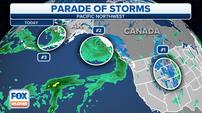
Several weather systems are lined up in the Pacific Ocean ready to pepper the Pacific Northwest with days of rain and mountain snow on the heels of months of record-dry and warm weather.
Rainy pattern to continue across Pacific Northwest bringing widespread rain to the region
Late Tuesday into Wednesday, yet another area of rain will move in, once again bringing more widespread rain to the region.
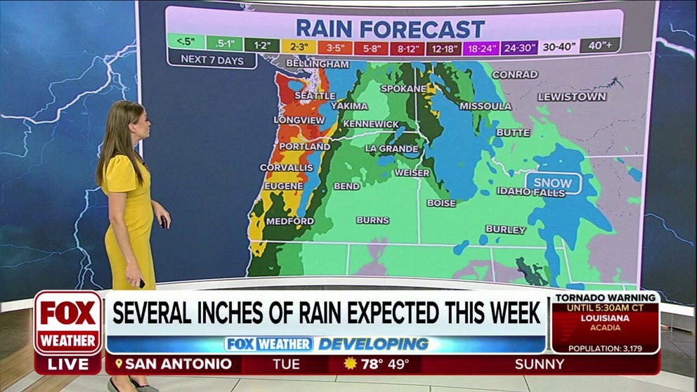
SEATTLE – Rain is in the forecast every day this week in Seattle and Portland, Oregon. Snow is falling in the mountains. Temperatures are struggling to get out of the 50s. Forecasters eye not just one weather system heading their way but several.
Autumn normalcy has finally returned to the Northwest.
The first storms blew through over the weekend, bringing the Northwest's first widespread and significant rains since early June. Portland indeed notched its wettest day since June on Saturday with 0.45 inches of rain. Seattle's 0.72 inches was more rain than August and September combined. Spokane, Washington, didn't reach 60 degrees for the first time in 128 days – its 12th-longest streak on record and the longest since 1987.
That storm headed into the Intermountain West, where heavy snow fell in the Rockies. Mountain ranges such as the Wasatch in Utah, Bitterroots in Montana and Idaho, Wind River in Wyoming and Rockies of Colorado were plastered with 10 to 20 inches of snow above 7,000 feet. In the higher elevations, like in Georgetown, Montana, 22 inches of snow fell over the past two days. Snow totals in Alta, Utah, weren't far behind with 20 inches.
Other areas picked up more than a foot of snow, including Big Sky and Bozeman in Montana and McGill in Nevada.
WEATHER WHIPLASH: POWERFUL AUTUMN STORM BRINGS HEAVY SNOW TO ROCKIES
But as the new workweek dawned, so did the arrival of the next storm lined up in a train of storms in the northern Pacific Ocean.
"It’s a typical pattern for the start of the wet season for Washington and Oregon, but the first one we’ve seen set up (this season)," FOX Weather meteorologist Britta Merwin said.
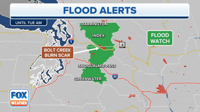
While weather impacts in the lowlands were minimal, Flash Flood Watches and Warnings had been issued for parts of the northern Cascades.
(FOX Weather)
Heavy rains triggered by a persistent Puget Sound Convergence Zone were falling across the area where the Bolt Creek Wildfire has been burning for several weeks.
"Darrington into Index – all the way down into Greenwater – we’re expecting a couple inches of rain over the next few days," Merwin said. "When you have a burn scar, all you have left is charred ground – there’s no vegetation to soak up the rain, and the soil is not prepped to soak up the rain so it just sort of stacks up and collects all the debris and it starts to flow outwards, and that leads to a very messy situation and also the threat of flash flooding."
The National Weather Service warns of rainfall rates at 0.5 inches per hour falling on the scorched landscape, creating the potential for flash flooding or mudflows in the area.
HOW WILDFIRE BURN SCARS COULD HAVE LASTING IMPACTS
Paging the Sesame Street Count…
A weather system that brought some rain Monday has already moved out, but there won't be much time to wring out because a second one is on the way for Tuesday evening…and another on Thursday… and another on Saturday, followed by a fifth on Sunday and perhaps even a sixth on Halloween Monday. Each one will bring several hours of steady rains in the lowlands and snowfall to higher elevations in the mountains.
(FOX Weather)
"As these Pacific fronts move through, you feel the wind pick up (and) the rain pick up, but once you get above 5,000 to 6,000 feet, you get a lot of snow," Merwin said. "And it’s the snow that helps us out with the wildfires at the higher elevations; the lower elevations will take any rainfall they can get."
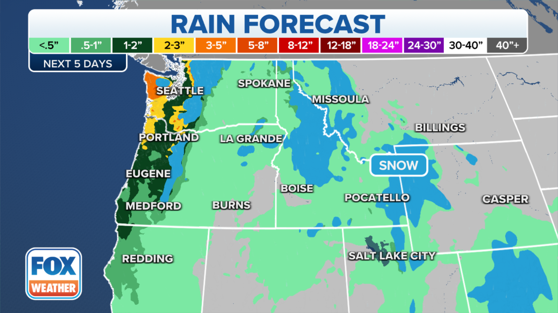
By the time those last storms of the week arrive, up to 3 inches of rain may have fallen in the Seattle-Portland corridor with heavier amounts in the mountains.
(FOX Weather)
The rains – and especially the mountain snows – will do wonders to douse the multiple wildfires that had been burning in the Northwest through the summer, leaving residents near the fires on constant alert to evacuate and sending choking smoke across the Northwest for days.
Merwin says the snow is even better for extinguishing wildfires as the snowfall has a bit of heavier air associated with it, and as the snow falls, it reduces the oxygen available that fuels the fire.
"That really helps you reduce and tap out those fires," Merwin said. "So it’s a great way to snuff it out."

(FOX Weather)
With La Niña forecast to make a third consecutive winter appearance, those in the Northwest should settle in for a rather rainy period.
The long-range winter forecasts issued last week by NOAA indicate a wetter- and cooler-than-average winter is likely.
WINTER PREDICTION SCOREBOARD: HOW ON-TARGET ARE SEASONAL OUTLOOKS?