Pacific Northwest heat wave continues Monday after setting monthly records Mother's Day weekend
Sunday marked the third consecutive day of record heat in Seattle, which topped out at 89 degrees, and also in Portland, which had a high of 92 degrees. But perhaps even more impressive was the pair of all-time May record highs set Sunday along the Pacific coast of Washington: 91 degrees in Hoquiam and 92 degrees in Quillayute.

Pacific Northwest heat wave continues Monday after record-setting weekend
After a weekend for the record books, with multiple locations hitting their record highs Sunday, one final day of record heat will be possible across much of Washington and Oregon Monday.
SEATTLE – After a three-month streak of generally below-average temperatures, the Pacific Northwest has undergone a radical shift to record-breaking heat as an intense ridge of high pressure remains settled over the region to begin the workweek.
Records began falling Friday as warmer air surged into the region. Seattle reached 82 degrees while Portland hit 90 degrees – both daily records for the cities. On Saturday, Seattle's 86-degree high and Portland's 93-degree high set daily records for the second straight day.
Sunday marked the third consecutive day of record heat in Seattle, which topped out at 89 degrees, and also in Portland, which had a high of 92 degrees. But perhaps even more impressive was the pair of all-time May record highs set Sunday along the Pacific coast of Washington: 91 degrees in Hoquiam and 92 degrees in Quillayute.
Heat Advisories remain in effect Monday for more than 9 million people across western Washington, northern Oregon and portions of California's Central Valley. High temperatures are again expected to reach the upper 80s to mid-90s for an area where air conditioning remains scant.
"(When) we lived in Seattle, we did not have central (air conditioning)," remembered FOX Weather meteorologist Craig Herrera. "You had to buy the unit that goes into the windows, and this time of year when you’ve got this kind of stretch (of heat), the hardware stores are running out of A/C’s. They’re running out of fans because … a survey from American Housing says that only 44% of households in Seattle have A/C – that’s nothing."
HOW TO TELL THE DIFFERENCE BETWEEN HEAT EXHAUSTION AND HEATSTROKE

(FOX Weather)
The National Weather Service warns of a major risk of heat-related illnesses in the region's lowlands and foothills for anyone who does not have access to effective cooling and/or adequate hydration.

(FOX Weather)
"These temperatures – you don't see this all too often," FOX Weather meteorologist Jane Minar said. "We've got this surge of warmth from the south, and it has really pumped up the temperatures from really the Central Valley in California clear on up that I-5 corridor."
While the Pacific Northwest will generally be in the mid- to upper 80s to near 90 degrees, highs could reach the mid- to upper 90s in portions of California's Central Valley, perhaps even approaching 100 degrees in Bakersfield Monday afternoon.

(FOX Weather)
And while the peak of the heat is pushing east, well-above-average temperatures are expected to hold through most of this week, with the added challenge of anomalous higher humidity levels for the region as some monsoonal moisture from the Desert Southwest works its way into the region.
Seattle could potentially reach a high temperature of at least 80 degrees for seven days in a row, which would shatter the previous May record of four 80-plus-degree days in a row. Monday is expected to be the fourth straight day of 80-degree warmth.
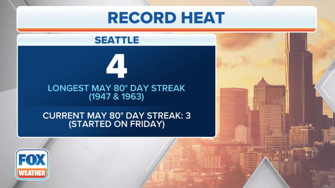
Monday is expected to be the fourth straight day of 80-degree warmth in Seattle, tying the May record for consecutive 80-degree days.
(FOX Weather)
"I think it's got many people wondering, is it mid-July?" Minar said.
The heat will send the ongoing snowmelt into overdrive, and area rivers and streams should expect to see rising levels this week.
Flooding concerns from snowmelt have already prompted the closure of several campgrounds at Yosemite National Park beginning Monday.
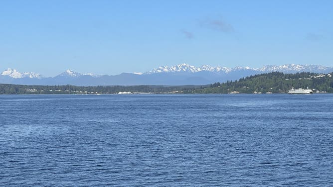
The snow-capped Olympic Mountains stand tall on a sunny and warm day as seen from the Edmonds-Kingston ferry run on May 10, 2023.
(Scott Sistek / FOX Weather)
The rapid warmup will also increase the risk of brush fires across the Pacific Northwest and could trigger an earlier start of the fire season, the NWS warned.
The air is hot, but the waters are cold
Officials are concerned many will head to the region's plentiful and inviting rivers and lakes to cool off.
But after a bountiful winter with a healthy snowpack covering the region's mountains, the ongoing heat wave will trigger rapid snowmelt, causing the area's rivers to run high … and cold.
The NWS is expressing serious concern there will be cold-water-related incidents with the heat and stresses for those heading out on the water to wear a life jacket.
The shock heading from air temperatures in the 80s and 90s to water temperatures in the 40s can lead to difficulty swimming, even for experienced swimmers, and can eventually lead to drowning if not wearing a flotation device.