Deadly cross-country winter storm blankets Pacific Northwest as ice cripples region
So far, over 50,000 people are without power in Oregon as of late Wednesday afternoon. Freezing rain fell much of the night across the Portland area.
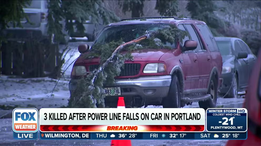
3 killed after power line falls on vehicle in Oregon
During an ice storm on Wednesday, a tree branch fell and brought a power line down onto a vehicle in northeast Portland. Two adults and one teenager stepped out of the affected vehicle, but where killed by the electric current when their feet touched the ground. A two-year-old that remained in the vehicle was uninjured. Jan. 17, 2024.
PORTLAND, Ore. – Fresh off the heels of a winter snow and ice storm that left two dead and more than 200,000 without power across northwestern Oregon and southwestern Washington over the weekend, another winter storm brought a volatile second punch before starting a cross-country journey with additional winter weather impacts.
The storm turned deadly Wednesday when three people in northeast Portland were killed after a tree branch fell and brought a live power line down onto their vehicle, according to Rick Graves, the public information officer for Portland Fire & Rescue. Two adults and one teenager inside the car left the vehicle and were electrocuted when their feet touched the ground. A two-year-old child that remained in the car is alive.
Snow and ice covered roads in Southwestern Washington on Jan. 17, 2024.
(Washington State DOT)
More than 50,000 people were without power in Oregon as of late Wednesday afternoon local time, according to PowerOutage.US, though a large percentage of those were still without power from Saturday's ice storm. Outages have since slowly dwindled.
(FOX Weather)
Icy roads forced the closure of two main interstates in the Pacific Northwest. In Oregon, Department of Transportation (DOT) crews closed a 47-mile stretch of Interstate 84 through the Columbia River Gorge ahead of the storm due to a forecast of heavy icing. Farther south, Interstate 5 was briefly closed south of Eugene after power lines fell across the freeway Tuesday evening, Oregon DOT crews said.
In Washington, Interstate 90's Snoqualmie Pass through the Cascades was shut down early Wednesday morning due to multiple crashes and spin-outs as freezing rain and snow fell, according to the Washington State DOT. The freeway reopened by mid-morning, but DOT crews warned severe winter weather conditions persist.
Just outside the closure west of North Bend, Washington, a Washington State Patrol trooper was injured when his patrol vehicle was struck while investigating a crash along I-90. He was taken to a local hospital and was expected to recover.
At least one other person was injured in a three-vehicle wreck involving a semi-truck on I-90 near Snoqualmie Pass, troopers said.
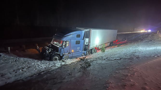
A semi-truck was involved in a three-vehicle crash along Washington's Interstate 90 near Snoqualmie Pass on Jan. 16, 2024.
(Washington State Patrol / FOX Weather)
Ice Storm Warnings were in effect overnight Tuesday for much of northwestern Oregon, including the Portland-Vancouver metro area and the Willamette Valley. Portland's is set to expire at 7 p.m. local time on Wednesday.
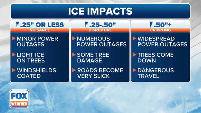
Total ice accretions reached 0.10-0.75 inches around the region as of late Tuesday night, according to the National Weather Service. A trained spotter in Camas, Washington, near Vancouver, measured 0.75 inches of ice accretion, while Hillsboro and Durham each reported 3/8-inch accretions Wednesday morning.
(FOX Weather)
Portland's light rail MAX service remained with service disruptions early Wednesday due to lingering damage from falling trees and snow and ice, and all parks and recreation facilities were closed Tuesday due to the impending ice storm.
Seattle area receives glancing blow of wintry weather
The storm spread a wintry mix north into Seattle and the I-5 corridor Tuesday night, bringing a round of light freezing rain to the region, except light snow near the Canadian border where colder air remained entrenched. Several school districts across the region either delayed or canceled classes Wednesday.
Winter Weather Advisories covered the Seattle area into mid-morning Wednesday.
HOW MUCH ICE IS NEEDED TO KNOCK OUT POWER, DAMAGE TREES?
However, with warmer air expected to mix out the colder air faster, any snow accumulations were brief and an inch or less. Any freezing rain glaze remained under a quarter-inch thick before changing to rain and tapering off.
The exception was an area near the Canadian border and along the northern Olympic Peninsula, where lingering chilly winds brought up to 5 inches of snow and a brief glaze of ice through Wednesday.
Heavy snow, freezing rain pummel the Cascades
On the other hand, there are no worries about cold air in the mountains as the storm brings another dose of heavy snow to the Cascades.

(FOX Weather)
Winter Storm Warnings remain in effect through Friday for additional snowfall between 20 and 30 inches and a glaze of ice amid wind gusts to 40 mph.
Snoqualmie Pass has received 40 inches of snow in just the past week.
Storm heads east to impact 30 states while atmospheric rivers take over West
Wintry conditions improved Wednesday in the Northwest, but the storm is just getting started with its national impact.
The storm will slide farther east across the Plains later in the week and eventually into the mid-Atlantic and Northeast. Right now, the FOX Forecast Center is not anticipating a blockbuster snowstorm, but disruptive snow amounts ranging from 1-5 inches are possible through the end of the week.

(FOX Weather)