NWS issued unprecedented Tornado Emergency in NJ hours before historic Schuylkill River flood in Philadelphia
Destructive tornadoes were followed by a historic flood in parts of Pennsylvania and New Jersey
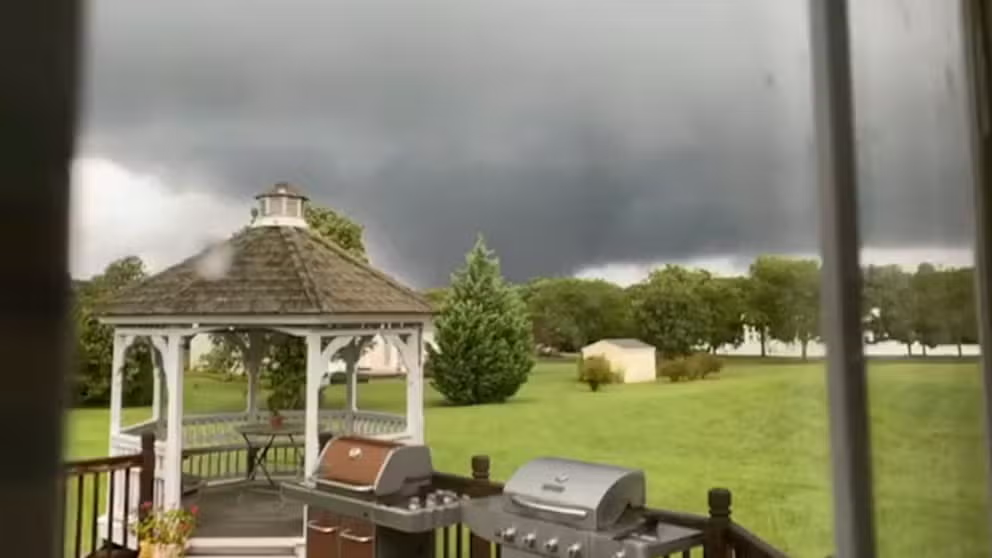
Tornadoes hit New Jersey and Maryland as storms from Ida sweep through
Tornadoes touch down in Maryland and New Jersey in the wake of Hurricane Ida sweeping through the Northeast.
The National Weather Service office in Mount Holly, New Jersey, issued 16 Tornado Warnings on Wednesday, including its first-ever Tornado Emergency, hours before the Schuylkill River reached its highest crest in nearly 152 years and flooded parts of Philadelphia on Thursday.
That's two additional Tornado Warnings than the 14 that were issued during the region's July 29 outbreak, which included the Mount Holly weather service's first "Particularly Dangerous Situation," or PDS, Tornado Warning, meaning there was credible evidence of a damaging tornado on the ground.
In fact, it took 3.5 pounds of paper to print out all the warnings – tornado, flash flood and severe thunderstorm – issued by the NWS in Mount Holly on Wednesday.
We print our warnings issued automatically for verification purposes. Between all new warnings and warning updates, it has added up to 3.5 pounds of paper over the last 24 hours! It has been incredibly busy, even on the midnight shift. Severe flooding continues across the area. pic.twitter.com/ofjoaTgDQJ
— NWS Mount Holly (@NWS_MountHolly) September 2, 2021
One such Tornado Warning issued Wednesday was even rarer than the PDS warning issued just over a month earlier.
At 7:04 p.m., the NWS issued a Tornado Emergency for Bristol and Croydon, Pennsylvania, and Burlington, New Jersey. This is the highest level of alert the NWS can issue for a tornado.
Tornado Emergency including Trenton NJ, Levittown PA, Hamilton Square NJ until 7:30 PM EDT pic.twitter.com/XqZp0amdv0
— NWS Tornado (@NWStornado) September 1, 2021
According to the NWS, Tornado Emergencies are reserved for rare situations when all of the following are true:
- A severe threat to human life is imminent or ongoing
- Catastrophic damage is imminent or ongoing
- Reliable sources confirm a damaging tornado on the ground (either storm spotters have an actual visual of the twister or Doppler radar imagery strongly suggests the existence of a damaging tornado)
The Mount Holly weather service office has issued 51 Tornado Warnings since June 1 – more than any other office in the United States.
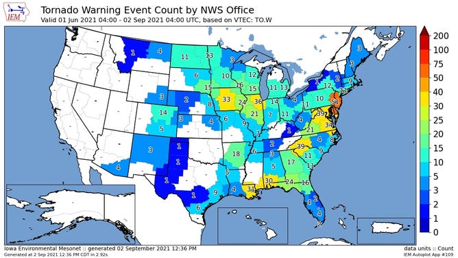
Number of Tornado Warnings issued by each National Weather Service office since June 1, 2021.
(Iowa Environmental Mesonet)
NWS storm surveys were in progress across the region on Thursday to determine the strength of Wednesday's tornadoes in Pennsylvania and New Jersey. As of Thursday afternoon, the NWS had confirmed that at least six tornadoes touched down in those two states.
AT LEAST 25 DEAD IN NORTHEAST AFTER FLOODING, TORNADOES DRIVEN BY IDA'S REMNANTS
The Mount Holly weather service also issued four Flash Flood Emergencies on Wednesday, which are "issued for exceedingly rare situations when a severe threat to human life and catastrophic damage from a flash flood is happening or will happen soon." It had issued four other Flash Flood Emergencies in the past.
However, the NWS office in New York City issued its first-ever Flash Flood Emergency Wednesday evening, then had to issue two more later Wednesday night. One of the emergencies covered more than 9 million people in the Big Apple and lower Hudson Valley.
The worst flooding I have personally ever seen in my life tonight in Jersey City. At least 13 cars are submerged for not turning around in flood waters. #TurnAroundDontDrown #njwx @foxweather pic.twitter.com/a6qU7q25mA
— Marissa Lautenbacher (@meteomarissa) September 2, 2021
While the city of Philadelphia picked up only 2.37 inches of rain Wednesday, many locations north and west of Philly received 6 to 9 inches of rain, with isolated areas receiving as much as 9 to 10 inches.
All-time records for one-hour rainfall were set Wednesday night in both New York City and Newark, New Jersey, where more than 3 inches fell in just an hour. Newark's rainfall total through midnight was a whopping 8.41 inches, smashing its all-time wettest day on record.
HOW IDA'S FLASH FLOODS IN NEW YORK COMPARE TO SUPERSTORM SANDY
Preliminary rainfall totals across the Mid-Atlantic and Northeast associated with Ida. A swath of 3-8" fell with isolated 9-10" totals led to numerous and widespread flash flooding Wednesday. pic.twitter.com/6CZRLlkNKW
— NWS Weather Prediction Center (@NWSWPC) September 2, 2021
All of this heavy rain caused the Schuylkill River in Philadelphia to reach its highest level since the record crest of Oct. 4, 1869. That was nearly 152 years ago.
On Thursday morning, the river level at the Philadelphia gauge was 16.35 feet, the second-highest crest on record. Flooding begins at 11 feet, according to the NWS.
The Vine Street Expressway (Interstate 676) in Center City, Philadelphia, was entirely submerged Thursday morning.
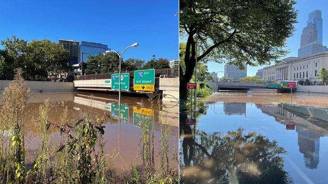
The Vine Street Expressway (Interstate 676) in Center City, Philadelphia, was entirely submerged Thursday morning, Sept. 2, 2021.
(FOX 29 Philadelphia)
Water levels on the Schuylkill River will gradually come down over the next 24 hours. The NWS said it's predicted to drop below flood stage by Friday morning.
The record flood of October 1869 was fueled by the outer bands of a hurricane, according to the Philadelphia Water Department, who noted that anywhere from 5 to 10 inches of rain fell over various parts of the Schuylkill River watershed.
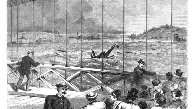
View of the Schuylkill River during the flood of Oct. 4, 1869, the highest flood on record. View is from the Wire Bridge (on the line of the present-day Spring Garden Street Bridge) looking upstream toward the Fairmount Dam (invisible under the water) and Boathouse Row.
(Cover illustration, Frank Leslie’s Illustrated Weekly, Oct. 23, 1869, via the Philadelphia Water Department)