Northeast braces for more rain, flooding chances as recovery operations continue
Flash flooding is possible across the Northeast and New England as we get closer to the end of the workweek. The FOX Forecast Center believes the highest risk of flash flooding will occur Thursday and Friday.

Vermont faces renewed flood concerns
After being flooded earlier this week, Vermont is again facing a threat of heavy rain Thursday.
Millions of Americans from Pennsylvania and New York through New England are cleaning up after deadly and historic flooding inundated cities and towns across the region. But as the recovery process continues, fears are growing that more rounds of rain could lead to additional chances of flooding in the coming days.
At least one person was killed in the flooding in New York, and Vermont is reeling after the state experienced its worst flooding event since 1927.
Rivers and streams have started to recede and are falling below flood stage, but the situation could turn dangerous once again with rain returning to the area.
Northeast, New England at risk of flash flooding

(FOX Weather)
Flash flooding is possible across the Northeast and New England as we get closer to the end of the workweek. The FOX Forecast Center believes the highest risk of flash flooding will occur Thursday and Friday.
On Thursday, the highest risk will be found across central and eastern New York state, northwestern Connecticut, western Massachusetts, Vermont, New Hampshire and western Maine.
The same storm system that produced tornadoes around Chicago on Wednesday could trigger a few strong to severe storms on from the Ohio Valley through northern New England.
The FOX Forecast Center expects the main threat from the storms to be damaging winds but an isolated hail or tornado threat cannot be ruled out.

(FOX Weather)
NEW YORK FLOOD VICTIM SAYS WATER ROSE SO FAST THAT HE ‘DIDN’T HAVE TIME TO THINK'
By Friday, the flash flood threat will shift farther to the east, with more of Connecticut at risk and portions of northwestern Rhode Island also at risk.
The flash flood threat will then lower on Saturday but could still be possible with any of the heavier rain and thunderstorms that develop.
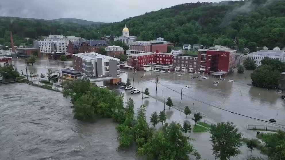
Watch: Haunting drone video shows Montpelier, Vermont, submerged in floodwaters
Dramatic drone video shows Montpelier, Vermont, submerged in floodwaters. Torrential rain across portions of the Northeast and New England sent rivers and streams above their banks leading to widespread flooding.
DRONE FOOTAGE SHOWS RAILROAD TRACKS SUSPENDED IN AIR AFTER VERMONT FLOODING WIPES OUT TRESTLE
Cities and towns across the Northeast and New England have picked up more than a half-foot of rain since Sunday, with some areas receiving more than 9 inches.
The rain on the way at the end of the week will only add to the already-saturated ground.
Vermont Gov. Phil Scott held a news conference on Tuesday and feared more flooding could occur with additional rain in the forecast.

(FOX Weather)
"Even though the sun may shine today and tomorrow, we expect more rain later this week, which will have nowhere to go in the oversaturated ground," Scott said at the news conference. "So I want to be clear – we are not out of the woods. This is nowhere near over, and at this phase, our primary focus continues to be on life and safety before we can shift into a recovery phase."
In terms of rain totals, the highest amounts are again expected from eastern New York state through New England.
Widespread totals of 2 to 3 inches are likely for most of the region. However, interior portions of New England will likely see higher amounts between 3 and 5 inches over the next seven days.