Rare May nor’easter begins to exit after delivering powerful winds, soaking rain ahead of holiday weekend
The low pressure system will weaken in the Gulf of Maine on Friday, but showers will linger across parts of New England and the interior Northeast through Saturday afternoon before the region finally dries out.

Late-season Nor'easter begins to make its exit ahead of Memorial Day
The nor'easter will weaken in the Gulf of Maine, but it'll keep the chances of numerous showers and across the Northeast. Those showers will linger across the interior Northeast on Saturday before everyone dries out.
BOSTON – A rare May nor’easter will make its exit across New England on Friday as it moves over the Gulf of Maine, bringing showers and wind to the coast and interior Northeast.
That's after the coastal storm drenched the East Coast on Thursday and made it feel more like fall than late spring for millions as frigid, windswept rain doused people hoping to get an early jump on Memorial Day weekend travel.
A nor’easter doesn’t need snow to fall. It's simply an area of low pressure with strong northeasterly winds off the Atlantic Ocean.
The low-pressure system will weaken in the Gulf of Maine on Friday, but showers will linger across parts of New England and the interior Northeast through Saturday afternoon before the region finally dries out.

(FOX Weather)
The strong coastal low-pressure system swirled off the coast of New York on Thursday as it developed, bringing steady, sometimes heavy rain from the New York City tri-state area up through New England. FOX Weather Meteorologist Britta Merwin was at Smith Point on Long Island in New York as she was pelted by rain and wind.
"We’ll have breakers about 1 to 3 feet," Merwin said. "It’s an offshore wind, so of course that’s going to impact the shape of the waves. As we go into this evening, the winds are going to pick up because this is truly just the beginning of our late-season nor’easter."

Late-season nor’easter blasting Northeast with heavy rain, high winds
Millions of people in the Northeast and New England hoping to get an early start to Memorial Day travel will likely face some delays on Thursday as a rare May nor’easter blasts the region. FOX Weather Meteorologist Britta Merwin was at Smith Point on Fire Island in New York as the storm was impacting the region on May 22, 2025.
As the storm edged closer to New England, rain and wind battered Rhode Island and Massachusetts.
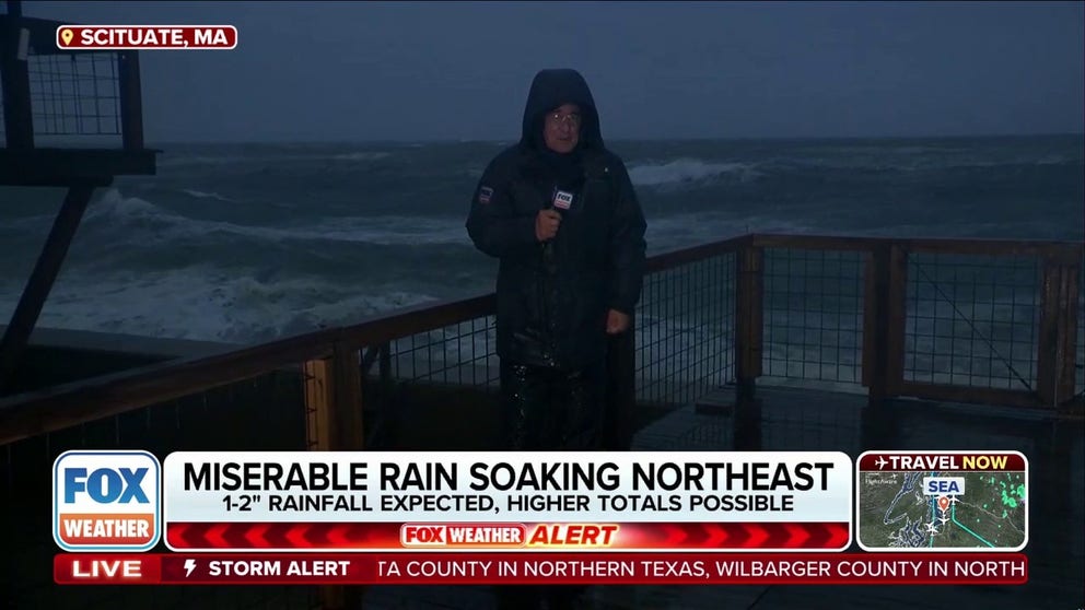
"Right now we're in the mid 40s - my hands are numb," said FOX Weather Storm Specialist Mike Seidel while reporting along a wind-swept beach in the pouring rain in Scituate, Massachusetts. "The wind chill is at 40 degrees."
Unusual May Nor'easter blasts New England
FOX Weather Storm Specialist Mike Seidel saw some of the worst of what the May Nor'easter had to offer in the Northeast, with driving rains and gusty winds along coastal Massachusetts.
Boston's temperature remained in the mid-upper 40s all day Thursday, with wind chills in the upper 30s, amid gusty winds of 35-40 mph. The city's preliminary high temperature as of Thursday evening was just 48 degrees, which was the coldest high temperature for May 22 since the early 1900s.
Boston's average temperature at this time of year is 68 degrees, with record highs in the lower 90s.
![A tree fell onto a road in Brookline, MA on Thursday.]() Image 1 of 2
Image 1 of 2A tree fell onto a road in Brookline, MA on Thursday. (@BrooklineMAPD/X)
![A tree fell onto a road in Brookline, MA on Thursday.]() Image 2 of 2
Image 2 of 2A tree fell onto a road in Brookline, MA on Thursday. (@BrooklineMAPD/X)


A large tree fell onto a road in Brookline, Massachusetts. Photos from the Brookline Police Department show the tree blocking the road, its roots lifting a sidewalk. According to the NWS, trees fell onto power lines in Cohasset and Hingham.
DOWNLOAD THE FREE FOX WEATHER APP
With rainfall totals reaching 1-2 inches, flash flooding is also a possibility. NOAA's Weather Prediction Center has placed portions of Connecticut, Rhode Island, Massachusetts, New Hampshire and Maine under a Level 1 out of 4 threat.

(FOX Weather)
Wind remained another problem, especially from eastern Long Island up through the New England coast. Continued wind gusts higher than 40 mph were reported, with some gusts expected to exceed 55 mph.
Wind gusts in Nantucket reached 54 mph on Thursday afternoon. It was enough to shutter ferry service between Hyannis and Nantucket, and between Woods Hole and Martha's Vineyard through the evening.
So far, the region's power grid has handled the storm with just minimal power outages reported scattered across New England.
Delays were reported at airports across the region, especially in Boston. At least 22% of flights originating from Boston Logan International were delayed Thursday, while roughly 34% of flights to Boston were delayed, according to Flightaware.

(FOX Weather)
Wind alerts remain posted for much of the New England coast through Friday morning.
Strong winds could also cause issues at the beach. While astronomical tides are not particularly high, a 1.5- to 2.5-foot water rise is still possible. If that occurs, minor coastal flooding could be a concern.
"Look at these wave heights," Seidel said as large waves crashed in the background. "These have got to be 7, 8, 9-footers."

Windy, rainy morning in coastal Massachusetts
Video from Scituate, Massachusetts, Thursday showed the wet, cold weather conditions brought on by a late-season Nor'easter.
Coastal Flood Advisories are also in effect for portions of the Northeast and New England. Bridge Street in Salem, Massachusetts was closed due to coastal flooding, reported the NWS.
In the highest peaks of New Hampshire's White Mountains, the nor’easter will pull in enough cold air to produce off-season snow accumulation, mainly above 1,500 feet.
The heaviest snow will fall on peaks above 3,000 feet in the Presidential Range, including Mount Washington in New Hampshire.