Los Angeles area back under Fire Weather Warning as strong Santa Ana winds return
Fire Weather Warnings are back in effect across Southern California, including portions of Los Angeles, Ventura, Orange, Riverside and San Bernardino counties through at least Wednesday.
Santa Ana winds could lead to rapid spread, erratic fire behavior
Dangerous Santa Ana winds are returning to Southern California, and that has forecasters and fire officials concerned that any new or existing fires could spread rapidly and display erratic behavior.
LOS ANGELES – Thousands of firefighters working to contain and extinguish a series of devastating and deadly wildfires in the Los Angeles area took advantage of a welcome break from the dangerous Santa Ana winds at the start of the weekend, but the break was brief as strong winds returned Sunday morning and are expected to pick up again beginning late Monday.
Fire Weather Warnings are back in effect across Southern California, including portions of Los Angeles, Ventura, Orange, Riverside and San Bernardino counties through at least Wednesday.
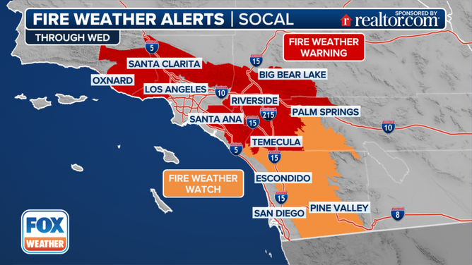
This graphic shows the Fire Weather Watches and Warnings in Southern California.
(FOX Weather)
The National Weather Service office in Los Angeles said periods of winds gusting 30-50 mph are expected, with gusts from 50-75 mph for wind-prone mountains and foothills through at least Tuesday. Strong winds arrived overnight Saturday into Sunday morning before calming down in the afternoon, and are expected to return starting late Monday into Tuesday.
"It will be very dry through the period with daytime humidities largely between 10 and 20 percent with minimal improvement at night," the NWS said. "The very dry vegetation combined with the prolonged extreme fire weather conditions will support rapid spread and erratic behavior of any new or existing fires."
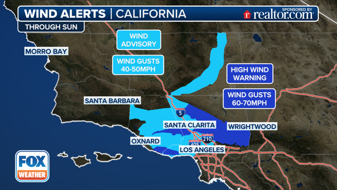
This graphic shows the wind alerts in effect in Southern California.
(FOX Weather)
Of even greater concern was the area around the Eaton Fire, where wind gusts from the northeast were expected to approach 60 mph, which could push the flames back toward populated areas.
"(Saturday night), gusty and dry Santa Ana winds developed along the northeast edge of the fire," CAL FIRE said in an update. "The strongest winds will be restricted to higher elevations and ridge tops. Lower elevations will most likely remain more sheltered."
Minimal fire growth was expected Sunday after officials said strong winds Saturday night contributed to "active fire behavior with interior flare-ups".
Worst Santa Ana winds since Tuesday's firestorms loom this week

Investigators to search for victims of deadly California wildfires as blazes rage
Investigators will begin using K9s and cadaver dogs to search the rubble of buildings that were destroyed by devastating and historic wildfires that have been burning across the Los Angeles region since last week. FOX Weather Meteorologist Marissa Torres was in Los Angeles on Sunday where helicopters could be heard overhead as they race to contain and extinguish the deadly fires.
Now, meteorologists are keeping a wary eye on the forecast for the middle of this week.
"The overall pattern looks something similar to what we saw earlier this week," FOX Weather Meteorologist Ian Oliver said. "High pressure up across portions of the Intermountain West. You get the northeast wind channel and down through some of those mountain passes, descending, compressing, warming and drying out as it approaches the coastline."
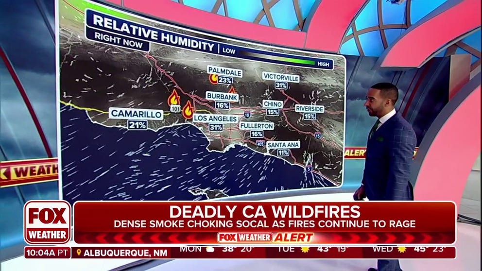
The drying aspect will once again drop relative humidity levels into the teens or single-digit percentages. Computer forecast models predict a relative humidity of just 9% in Los Angeles on Tuesday afternoon.
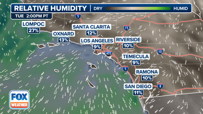
This graphic shows the relative humidity forecast on Tuesday, Jan. 14, 2025.
(FOX Weather)
Meanwhile, wind gusts will near or exceed damaging levels in the Santa Ana wind-prone areas, especially in the mountains and passes around the Los Angeles area.
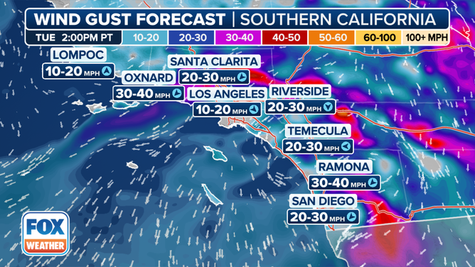
This graphic shows the wind gust forecast in Southern California on Tuesday, Jan. 14, 2025.
(FOX Weather)
"There is great concern that fire weather conditions could become exacerbated given the antecedent conditions, little rain across the area since the spring of 2024, and another offshore wind event on top of all of what we have seen, so far," NWS Los Angeles forecasters wrote. "Residents are urged to stay tuned to the latest information and remain vigilant in steps to protect your life and property."
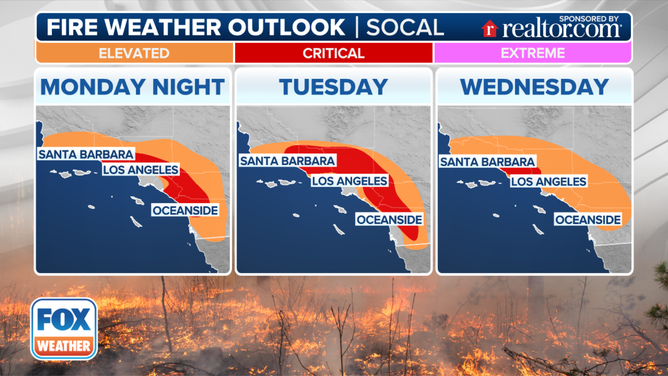
This graphic shows the fire weather forecast in Southern California.
(FOX Weather)
That bout of wind is forecast to wane on Wednesday. But how does Southern California get out of this dangerously dry and windy pattern?
"The big issue and what would fix all of this is some rain," Oliver said.
However, the FOX Forecast Center said it doesn't expect rain in the area for at least the next seven days.