Lake-effect rain event soaks Great Lakes metro areas, including Interstate 90 corridor
Lake-effect rain refers to a phenomenon that generally occurs during the fall when cold air moves over the warmer Great Lakes, creating instability in the atmosphere, causing rain and potentially severe storms to develop. Buffalo recorded 1.81 inches of rain on Wednesday, breaking a 113-year-old daily rainfall record.

Lake-effect rain soaks Interstate 90 corridor along Great Lakes
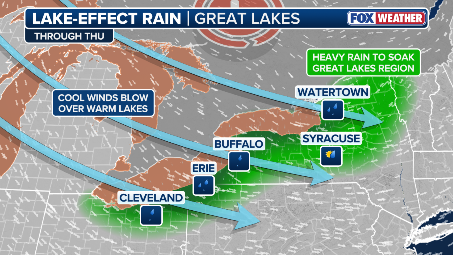
A low-pressure system over the Great Lakes region is triggering the development of lake-effect rain bands across the eastern sides of lakes Michigan, Erie and Ontario. Detroit, Cleveland and Buffalo, New York also waves of rain showers and even some severe weather Wednesday. This wet weather pattern will last through Thursday.
BUFFALO, N.Y. – A low-pressure system over the Great Lakes region continues to fuel lake-effect rain bands on the eastern sides of lakes Michigan, Erie and Ontario and the southern side of Lake Superior.
The National Weather Service offices in Buffalo, New York, and Cleveland described the setup as a "long-duration" and "prolonged" lake-effect rain event, respectively. A widespread 1-2 inches of rain, with locally up to 3 inches, along the Interstate 90 corridor between Buffalo and Cleveland through the end of the week.
Buffalo recorded 1.81 inches of rain on Wednesday, breaking a 113-year-old daily rainfall record.

(FOX Weather)
Bands of heavy rain were seen on time-lapse video from Detroit, Cleveland and Buffalo on Wednesday. Tuesday's storms even produced frozen water droplets known as graupel in Finleyville, Pennsylvania.
Social media video showed cars driving through flooded roads in Erie, Pa., on Thursday as the lake-effect rainfall impacted the region.

Streets flooded in Erie, Pennsylvania, after heavy lake-effect rain
Heavy lake-effect rainfall inundated roads in parts of northwest Pennsylvania on Thursday, Oct. 23.
Lake-effect rain refers to a phenomenon that generally occurs during the fall when cold air moves over the warmer Great Lakes, creating instability in the atmosphere, causing rain and potentially severe storms to develop. That precipitation is currently being driven to the east by westerly winds.
Water temperatures are more than 4 degrees above average across all the Great Lakes.
(FOX Weather)
According to the FOX Forecast Center, overnight low temperatures are in the 30s and 40s, potentially cold enough for some very light snow near the Upper Peninsula of Michigan.
In addition to the rain, the lake-effect event brought widespread wind gusts of 30–40 mph across much of the region through Thursday, making the cool temperatures feel even colder.

Lightning dazzles over Lake Erie, part of long-duration lake-effect rain
Lightning dazzled over Lake Erie, as seen from Buffalo, New York. A low-pressure system over the Great Lakes region will trigger the development of lake-effect rain bands on the eastern sides of lakes Michigan, Erie and Ontario and the south side of Lake Superior through Thursday.
The heavy rain began to taper off Thursday evening, with some precipitation lingering and shifting south through Friday.
While the deluge reduced visibility for drivers, hampering travel, the rain will be beneficial for parts of Michigan and western New York that are in moderate to severe drought, according to the U.S. Drought Monitor.