Water rescues reported in Atlanta as millions face severe weather, flash flood threats in South
NOAA’s Storm Prediction Center has highlighted three areas of concern where strong to severe thunderstorms could fire up Wednesday – North Texas, the Florida Peninsula and South Carolina. The main threats are large hail and damaging wind gusts. However, there is a small risk of tornadoes along Florida’s east coast.

Watch: Flash flooding, water rescues reported in Atlanta Wednesday morning
Video from FOX 5 in Atlanta shows flash flooding and water rescues that took place when heavy rain moved through the area early Wednesday morning
ATLANTA – Flash flooding and water rescues were reported in the Atlanta metro area Wednesday morning, and millions of people will continue to be at risk of seeing severe weather across the South through the rest of the week.
FOX 5 Atlanta reports that emergency crews were out in full force throughout the day responding to requests for help, including residents of a home that was damaged by a falling tree, as well as from people who became trapped by rapidly rising water.

Watch: Residents rescued after tree falls on home during severe weather in Atlanta
FOX 5 Atlanta shared video of residents being rescued from a home after a tree fell on top of it during severe weather early Wednesday morning.
Several crashes were also reported on local roads and highways, which led to slower travel times during the Wednesday morning commute.
Atlanta’s iconic Mary Mac’s Tea Room was severely damaged after the roof collapsed as torrential rain was falling.
Severe weather threat continues for millions through the rest of the week

(FOX Weather)
The Southeast is getting a brief break from the heavier action Wednesday before the next round of showers and storms Thursday.
There are a few exceptions, however.
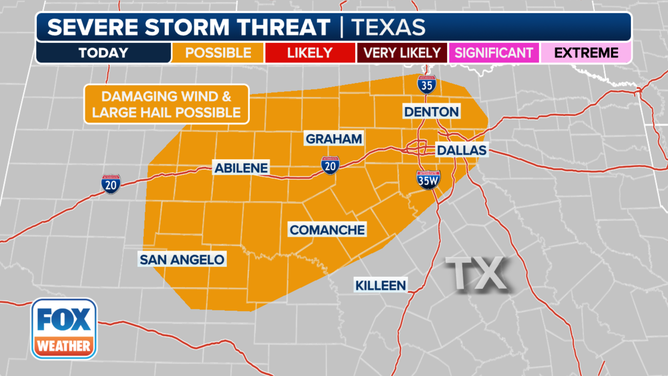
This graphic shows the severe thunderstorm threat in Texas on Wednesday, March 6, 2024.
(FOX Weather)
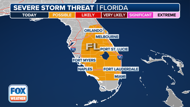
This graphic shows the severe thunderstorm risk in Florida on Wednesday, March 6, 2024.
(FOX Weather)
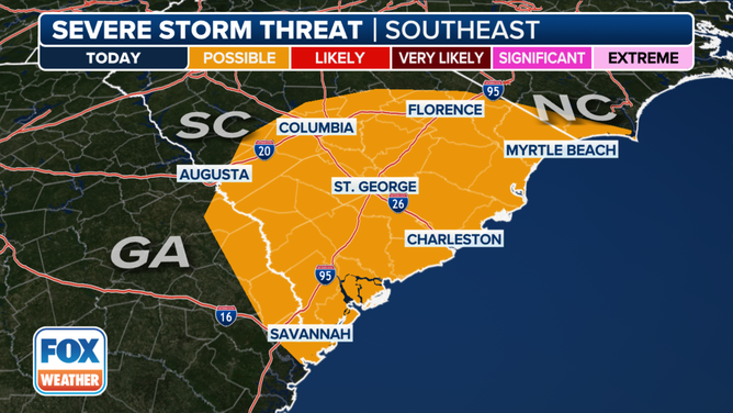
This graphic shows the severe thunderstorm threat in Georgia, South Carolina and North Carolina on Wednesday, March 6, 2024.
(FOX Weather)
NOAA’s Storm Prediction Center (SPC) has highlighted three areas of concern where strong to severe thunderstorms could fire up on Wednesday – North Texas, the Florida Peninsula and South Carolina.
The main threats from any thunderstorms that develop on Wednesday will be large hail and damaging wind gusts. However, there is a small risk of tornadoes along Florida’s east coast from Melbourne southward through Vero Beach, West Palm Beach, Fort Lauderdale and Miami.
WATCH VS. WARNING: HERE ARE THE DIFFERENCES BETWEEN THESE WEATHER TERMS THAT COULD SAVE YOUR LIFE
Threat for severe weather grows on Thursday, Friday
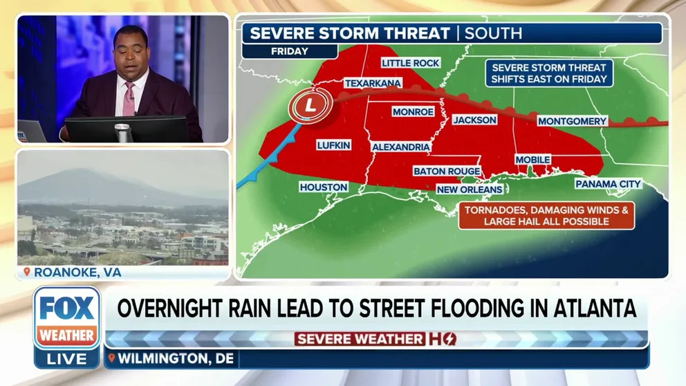
Tornadoes, damaging wind, hail possible as severe weather threat remains across South
Millions of people in the South are on alert as a multiday severe weather threat could bring damaging wind gusts, large hail and even tornadoes to places from the southern Plans to the Gulf Coast and Florida.
The end of the workweek could be interesting as more severe storms with the potential of producing large hail, damaging wind gusts and possible tornadoes could develop from Texas in the southern Plains to the Deep South and Gulf Coast.
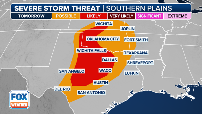
Nearly 9 million people from Central Texas, western Oklahoma and southern Kansas have been placed in a Level 2 risk on the SPC’s 5-point severe thunderstorm risk scale Thursday.
DOWNLOAD THE FREE FOX WEATHER APP
This graphic shows the severe weather threat on Thursday, March 7, 2024.
(FOX Weather)
This includes the Texas cities of Abilene, Dallas, Waco and Wichita Falls. In Oklahoma, the cities of Fort Sill and Woodward will be at risk.
Additionally, more than 8 million people are in a Level 1 out of 5 risk of severe weather on Thursday, and that includes cities such as San Antonio and Austin in Texas and Oklahoma City and Tulsa in Oklahoma.
HOW HEAVY IS IT REALLY GOING TO RAIN?
This graphic shows the severe weather threat on Friday, March 8, 2024.
(FOX Weather)
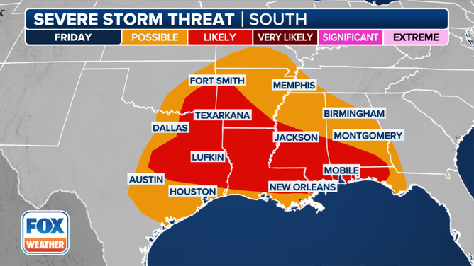
The severe thunderstorm risk on Friday will expand farther to the east, with more than 12 million people in a Level 2 out of 5 risk.
That includes Waco and Lufkin in Texas, Shreveport, Alexandria and New Orleans in Louisiana, Jackson in Mississippi and Mobile in Alabama.
A much larger Level 1 risk encompasses more than 25 million people from Central and East Texas into the lower Mississippi Valley, mid-South and along the central Gulf Coast as far east as the Florida Panhandle.