‘Unprecedented’ flooding swamps Milwaukee leading to water rescues as deadly storms slam Midwest
Officials announced Saturday night that the Wisconsin State Fair would be closed early because of the flooding, and that also forced the cancellation of a planned Lynyrd Skynyrd concert that evening. Officials made the difficult decision to keep the Wisconsin State Fair closed on Sunday, which was expected to be its last day.

Weekend flooding slams Milwaukee, southeastern Wisconsin
Weekend flooding swamped portions of southeastern Wisconsin, including the Milwaukee area, over the weekend, with many reports of homes being flooding and people needing to be rescued. FOX 6 News Milwaukee Reporter Bowen Kedrowicz joined FOX Weather from Wauwatosa on Aug. 11 with the latest.
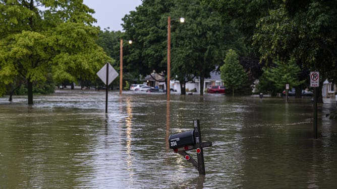
MILWAUKEE – A dangerous flash flooding situation unfolded across portions of Wisconsin, including the Milwaukee area, in the Midwest over the weekend, leading to numerous reports of flooded roads and homes and water rescues.
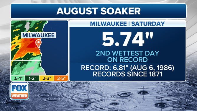
This graphic shows information on Milwaukee's rainfall totals.
(FOX Weather)
The rounds of torrential rain and thunderstorms led to Milwaukee seeing its second-wettest day on record on Saturday.
"This is some unprecedented flooding that we have seen across the Milwaukee area. Radar estimating over 10 inches in a handful of communities and that’s in a fairly short period of time," FOX 6 News Milwaukee Meteorologist Stephanie Barichello said during an interview with FOX Weather on Sunday morning.
DOWNLOAD THE FREE FOX WEATHER APP

Watch: Fairgoers wade through water after flooding forces closure of Wisconsin State Fair
A video shared by FOX 6 News Milwaukee shows children running and playing in water at the Wisconsin State Fair as torrential rain fell on Aug. 9, 2025. Fair officials were forced to close the fair early on Saturday night and said it would remain closed on Sunday due to the flooding.
Officials announced Saturday night that the Wisconsin State Fair would be closed early because of the flooding, and that also forced the cancellation of a planned Lynyrd Skynyrd concert that evening.
And because of the continued threat, officials made the difficult decision to keep the Wisconsin State Fair closed on Sunday, which was expected to be its last day.

Watch: Drone video captures scope of Wisconsin flooding
A video shared by FOX 6 News Milwaukee shows the scope of flooding that hit southeastern Wisconsin over the weekend.
"We are saddened we cannot deliver this final day of the Wisconsin State Fair, but know that this is the best decision with current conditions and the forecast ahead," officials said.
SHIPWRECKS DATING BACK TO 1700S UNCOVERED ALONG NORTH CAROLINA SHORELINE

Watch: Heavy rain floods roads, neighborhoods in Wisconsin
A video shared from Wauwatosa, Wisconsin, shows roads and neighborhoods that were flooded after torrential rain fell on Saturday, Aug. 9.
As the dangerous situation unfolded, officials were urging residents to keep an eye on the forecast and prepare to take action to stay safe.
"We’re seeing reports from some parts of the city that have received more than a foot of rain in a very short period of time," Milwaukee Mayor Chevy Johnson said on Sunday. "This flooding event, it’s very significant."
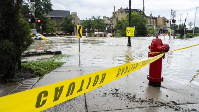
WAUWATOSA, WISCONSIN - AUGUST 10: Caution tape marks off a pedestrian pathway from flooding on August 10, 2025 in downtown Wauwatosa, Wisconsin. Heavy downpours brought as much as 13 inches of rain to parts of southeast Wisconsin overnight causing floods across the region. (Photo by Andy Manis/Getty Images)
(Getty Images)
Milwaukee County Executive David Crowley urged residents to stay vigilant.
"My team, we’re working actively with municipal first responders all across Milwaukee County to address the immediate needs of the affected people and to assure the safety of the entire public," he said. "With that in mind, I am declaring a state of emergency all across Milwaukee County to empower our emergency management personnel to deploy more additional resources to activate out state and federal partners to assist us with our efforts right here on the ground within Milwaukee County and to help people be safe."

Watch: Vehicles drive through floodwaters at Wisconsin State Fair
A video shared by FOX 6 News Milwaukee shows vehicles traveling through floodwaters outside the Wisconsin State Fair in West Allis on Aug. 9, 2025.
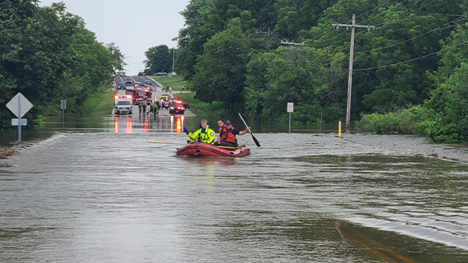
Numerous roads across the region were closed by first responders due to the rushing water, making the situation extremely dangerous for anyone traveling in the area.
"Since about 8 o’clock last night, Milwaukee Fire Department has worked extremely hard taking between 8 o’clock last night and 7 o’clock this morning, approximately 614 separate and distinct emergency assignments," Milwaukee Fire Department Chief Aaron Lipski said Sunday.
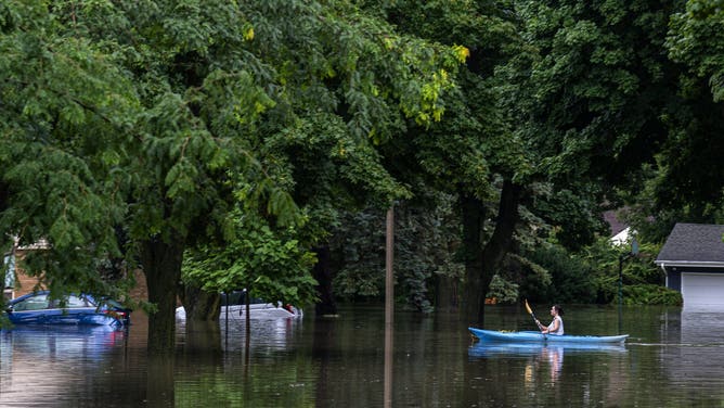
WAUWATOSA, WISCONSIN - AUGUST 10: A kayaker navigates flooding on August 10, 2025 in Wauwatosa, Wisconsin. Heavy downpours brought as much as 13 inches of rain to parts of southeast Wisconsin overnight, resulting in widespread flooding across the region. (Photo by Andy Manis/Getty Images)
(Getty Images)
Those calls were for everything from electrical trouble due to water working its way into electrical components to natural gas leaks, trees onto wires and exploding transformers.
"Just in that time, we had approximately 65 water rescue assignments for people such as the people that you’re witnessing behind us here," he said as a car was driving through floodwaters. "Who are just smarter than everybody else. We’ve been telling people over and over and over again, don’t drive through the water, but they know better. This is how we have hundreds of vehicles around the city, blocking intersections, making progress absolutely impossible."
SHIPWRECKS DATING BACK TO 1700S UNCOVERED ALONG NORTH CAROLINA SHORELINE
This photo provided by the Franklin Fire Department in Wisconsin shows a teenager being rescued from floodwaters on Aug. 10, 2025.
(Franklin Fire Department/Facebook / FOX Weather)
In Franklin, southwest of Milwaukee, a teenager was swept downstream and needed to be rescued by first responders.
According to the Franklin Fire Department, a 911 call was received just before 4:30 p.m. local time on Sunday indicating that someone was missing in the Root River off West Drexel Avenue.
Several units were dispatched to the scene, including the Greenfield Police Department’s Unmanned Aerial Vehicle (drone) to search for the victim.
WAUWATOSA, WISCONSIN - AUGUST 10: Flooding along the Menomonee River on August 10, 2025 in Wauwatosa, Wisconsin. Heavy downpours brought as much as 13 inches of rain to parts of southeast Wisconsin overnight, resulting in widespread flooding across the region. (Photo by Andy Manis/Getty Images)
(Getty Images)
When units arrived at the scene, officials said the water on the Root River was extremely high, was flowing over its banks and was moving across Drexel Avenue with a strong current.
Officials said that the road was closed at the time and had been marked with barriers to deter access to the flood zone.
A search began for the victim, who was described as a male teenager, and eventually crews were able to make voice contact with him.
WATCH: TREE CRASHES INTO ALLIGATOR LAGOON IN FLORIDA
![WAUWATOSA, WISCONSIN - AUGUST 10: A firefighter watches over flooding on August 10, 2025 in downtown Wauwatosa, Wisconsin. Heavy downpours brought as much as 13 inches of rain to parts of southeast Wisconsin overnight causing floods across the region. (Photo by Andy Manis/Getty Images)]() Image 1 of 21
Image 1 of 21WAUWATOSA, WISCONSIN - AUGUST 10: A firefighter watches over flooding on August 10, 2025 in downtown Wauwatosa, Wisconsin. Heavy downpours brought as much as 13 inches of rain to parts of southeast Wisconsin overnight causing floods across the region. (Photo by Andy Manis/Getty Images) ( )
![WAUWATOSA, WISCONSIN - AUGUST 10: A man looks at flooding on August 10, 2025 in Wauwatosa, Wisconsin. Heavy downpours brought as much as 13 inches of rain to parts of southeast Wisconsin overnight causing floods across the region. (Photo by Andy Manis/Getty Images)]() Image 2 of 21
Image 2 of 21WAUWATOSA, WISCONSIN - AUGUST 10: A man looks at flooding on August 10, 2025 in Wauwatosa, Wisconsin. Heavy downpours brought as much as 13 inches of rain to parts of southeast Wisconsin overnight causing floods across the region. (Photo by Andy Manis/Getty Images) ( )
![WAUWATOSA, WISCONSIN - AUGUST 10: Caution tape marks off a pedestrian pathway from flooding on August 10, 2025 in downtown Wauwatosa, Wisconsin. Heavy downpours brought as much as 13 inches of rain to parts of southeast Wisconsin overnight causing floods across the region. (Photo by Andy Manis/Getty Images)]() Image 3 of 21
Image 3 of 21WAUWATOSA, WISCONSIN - AUGUST 10: Caution tape marks off a pedestrian pathway from flooding on August 10, 2025 in downtown Wauwatosa, Wisconsin. Heavy downpours brought as much as 13 inches of rain to parts of southeast Wisconsin overnight causing floods across the region. (Photo by Andy Manis/Getty Images) ( )
![WAUWATOSA, WISCONSIN - AUGUST 10: (EDITOR'S NOTE: Alternate crop) First responders rescue people from flooding in their homes on August 10, 2025 in Wauwatosa, Wisconsin. Heavy downpours brought as much as 13 inches of rain to parts of southeast Wisconsin overnight, resulting in widespread flooding across the region. (Photo by Andy Manis/Getty Images)]() Image 4 of 21
Image 4 of 21WAUWATOSA, WISCONSIN - AUGUST 10: (EDITOR'S NOTE: Alternate crop) First responders rescue people from flooding in their homes on August 10, 2025 in Wauwatosa, Wisconsin. Heavy downpours brought as much as 13 inches of rain to parts of southeast Wisconsin overnight, resulting in widespread flooding across the region. (Photo by Andy Manis/Getty Images) ( )
![WAUWATOSA, WISCONSIN - AUGUST 10: A kayaker navigates flooding on August 10, 2025 in Wauwatosa, Wisconsin. Heavy downpours brought as much as 13 inches of rain to parts of southeast Wisconsin overnight, resulting in widespread flooding across the region. (Photo by Andy Manis/Getty Images)]() Image 5 of 21
Image 5 of 21WAUWATOSA, WISCONSIN - AUGUST 10: A kayaker navigates flooding on August 10, 2025 in Wauwatosa, Wisconsin. Heavy downpours brought as much as 13 inches of rain to parts of southeast Wisconsin overnight, resulting in widespread flooding across the region. (Photo by Andy Manis/Getty Images) ( )
![WAUWATOSA, WISCONSIN - AUGUST 10: First responders rescue people from flooding in their homes on August 10, 2025 in Wauwatosa, Wisconsin. Heavy downpours brought as much as 13 inches of rain to parts of southeast Wisconsin overnight, resulting in widespread flooding across the region. (Photo by Andy Manis/Getty Images)]() Image 6 of 21
Image 6 of 21WAUWATOSA, WISCONSIN - AUGUST 10: First responders rescue people from flooding in their homes on August 10, 2025 in Wauwatosa, Wisconsin. Heavy downpours brought as much as 13 inches of rain to parts of southeast Wisconsin overnight, resulting in widespread flooding across the region. (Photo by Andy Manis/Getty Images) ( )
![WAUWATOSA, WISCONSIN - AUGUST 10: Flooding along the Menomonee River on August 10, 2025 in Wauwatosa, Wisconsin. Heavy downpours brought as much as 13 inches of rain to parts of southeast Wisconsin overnight, resulting in widespread flooding across the region. (Photo by Andy Manis/Getty Images)]() Image 7 of 21
Image 7 of 21WAUWATOSA, WISCONSIN - AUGUST 10: Flooding along the Menomonee River on August 10, 2025 in Wauwatosa, Wisconsin. Heavy downpours brought as much as 13 inches of rain to parts of southeast Wisconsin overnight, resulting in widespread flooding across the region. (Photo by Andy Manis/Getty Images) ( )
![MILWAUKEE, WISCONSIN - AUGUST 10: People watch as debris piles up on a bridge piling on the Milwaukee River after heavy rain in the area on August 10, 2025 in Milwaukee, Wisconsin. Heavy downpours brought as much as 13 inches of rain to parts of southeast Wisconsin overnight, resulting in widespread flooding across the region. (Photo by Andy Manis/Getty Images)]() Image 8 of 21
Image 8 of 21MILWAUKEE, WISCONSIN - AUGUST 10: People watch as debris piles up on a bridge piling on the Milwaukee River after heavy rain in the area on August 10, 2025 in Milwaukee, Wisconsin. Heavy downpours brought as much as 13 inches of rain to parts of southeast Wisconsin overnight, resulting in widespread flooding across the region. (Photo by Andy Manis/Getty Images) ( )
![This photo provided by the Franklin Fire Department in Wisconsin shows a teenager being rescued from floodwaters on Aug. 10, 2025.]() Image 9 of 21
Image 9 of 21This photo provided by the Franklin Fire Department in Wisconsin shows a teenager being rescued from floodwaters on Aug. 10, 2025. (Franklin Fire Department/Facebook)
![This photo provided by the Franklin Fire Department in Wisconsin shows a teenager being rescued from floodwaters on Aug. 10, 2025.]() Image 10 of 21
Image 10 of 21This photo provided by the Franklin Fire Department in Wisconsin shows a teenager being rescued from floodwaters on Aug. 10, 2025. (Franklin Fire Department/Facebook)
![This photo provided by the Franklin Fire Department in Wisconsin shows a teenager being rescued from floodwaters on Aug. 10, 2025.]() Image 11 of 21
Image 11 of 21This photo provided by the Franklin Fire Department in Wisconsin shows a teenager being rescued from floodwaters on Aug. 10, 2025. (Franklin Fire Department/Facebook)
![This image shows extensive flooding that occurred in Wauwatosa, Wisconsin, on Aug. 10, 2025.]() Image 12 of 21
Image 12 of 21This image shows extensive flooding that occurred in Wauwatosa, Wisconsin, on Aug. 10, 2025. (@troyvosseller/X)
![This image shows extensive flooding that occurred in Wauwatosa, Wisconsin, on Aug. 10, 2025.]() Image 13 of 21
Image 13 of 21This image shows extensive flooding that occurred in Wauwatosa, Wisconsin, on Aug. 10, 2025. (@troyvosseller/X)
![This image from FOX 6 News Milwaukee shows vehicles driving through floodwaters outside the Wisconsin State Fair in West Allis on Saturday, Aug. 9, 2025.]() Image 14 of 21
Image 14 of 21This image from FOX 6 News Milwaukee shows vehicles driving through floodwaters outside the Wisconsin State Fair in West Allis on Saturday, Aug. 9, 2025. ( )
![This image from FOX 6 News Milwaukee shows vehicles driving through floodwaters outside the Wisconsin State Fair in West Allis on Saturday, Aug. 9, 2025.]() Image 15 of 21
Image 15 of 21This image from FOX 6 News Milwaukee shows vehicles driving through floodwaters outside the Wisconsin State Fair in West Allis on Saturday, Aug. 9, 2025. ( )
![This image shows people wading through floodwaters at the Wisconsin State Fair in West Allis on Saturday, Aug. 9, 2025.]() Image 16 of 21
Image 16 of 21This image shows people wading through floodwaters at the Wisconsin State Fair in West Allis on Saturday, Aug. 9, 2025. ( )
![This image shows people wading through floodwaters at the Wisconsin State Fair in West Allis on Saturday, Aug. 9, 2025.]() Image 17 of 21
Image 17 of 21This image shows people wading through floodwaters at the Wisconsin State Fair in West Allis on Saturday, Aug. 9, 2025. ( )
![This image shows people wading through floodwaters at the Wisconsin State Fair in West Allis on Saturday, Aug. 9, 2025.]() Image 18 of 21
Image 18 of 21This image shows people wading through floodwaters at the Wisconsin State Fair in West Allis on Saturday, Aug. 9, 2025. ( )
![This image shows people wading through floodwaters at the Wisconsin State Fair in West Allis on Saturday, Aug. 9, 2025.]() Image 19 of 21
Image 19 of 21This image shows people wading through floodwaters at the Wisconsin State Fair in West Allis on Saturday, Aug. 9, 2025. ( )
![This image shows flooding that occurred in Big Bend, Wisconsin, on Aug. 9, 2025.]() Image 20 of 21
Image 20 of 21This image shows flooding that occurred in Big Bend, Wisconsin, on Aug. 9, 2025. (Big Bend Fire Department/Facebook)
![This image shows flooding that occurred in Big Bend, Wisconsin, on Aug. 9, 2025.]() Image 21 of 21
Image 21 of 21This image shows flooding that occurred in Big Bend, Wisconsin, on Aug. 9, 2025. (Big Bend Fire Department/Facebook)


Officials said the teen was holding onto a tree branch while standing on a submerged log in the rapidly moving water about 100 yards downstream from where he entered the water.
"Although (rescuers) could not initially see the subject, responders stayed in constant contact reassuring him to stay calm and continue to hold onto the tree until rescuers arrived," officials said.
The teen was eventually rescued via an inflatable boat, and he was brought to shore where he was checked out by paramedics and was reunited with his family.
"This incident serves as a stark reminder of the dangers posed by flood waters," officials said "Never walk or drive through flooded roadways or around barricades. Moving water as shallow as six inches can knock an adult off their feet, and two feet of moving water can sweep away most vehicles."
Woman killed after tree falls on vehicle in Nebraska

Watch: Intense storm produces vivid lightning, strong winds in Nebraska
An intense video shared from Valley, Nebraska, shows vivid lightning and strong winds as a powerful storm swept across the area on Aug. 8, 2025.
The central Plains were also slammed by severe weather over the weekend, leading to the death of at least one person in Nebraska.
According to the Waterloo Fire Department, emergency crews responded to reports of an injury at Two Rivers State Park on Saturday evening. Officials said a large cottonwood tree had fallen onto the vehicle, trapping a man and woman inside.
The woman was declared dead at the scene, and the man was pinned in the vehicle.
"The extraction process was complex and challenging due to the size and weight of the cottonwood tree," officials said in a Facebook post. "Emergency responders worked diligently for approximately 90 minutes to free the male patient from the wreckage."
He was then taken to a local hospital with what officials describe as life-threatening injuries.
"We are deeply saddened by the loss of life in this tragic incident and want to express our heartfelt condolences to the victim’s family," officials said. "We are so grateful for the coordinated efforts of all the agencies involved in this complex rescue."
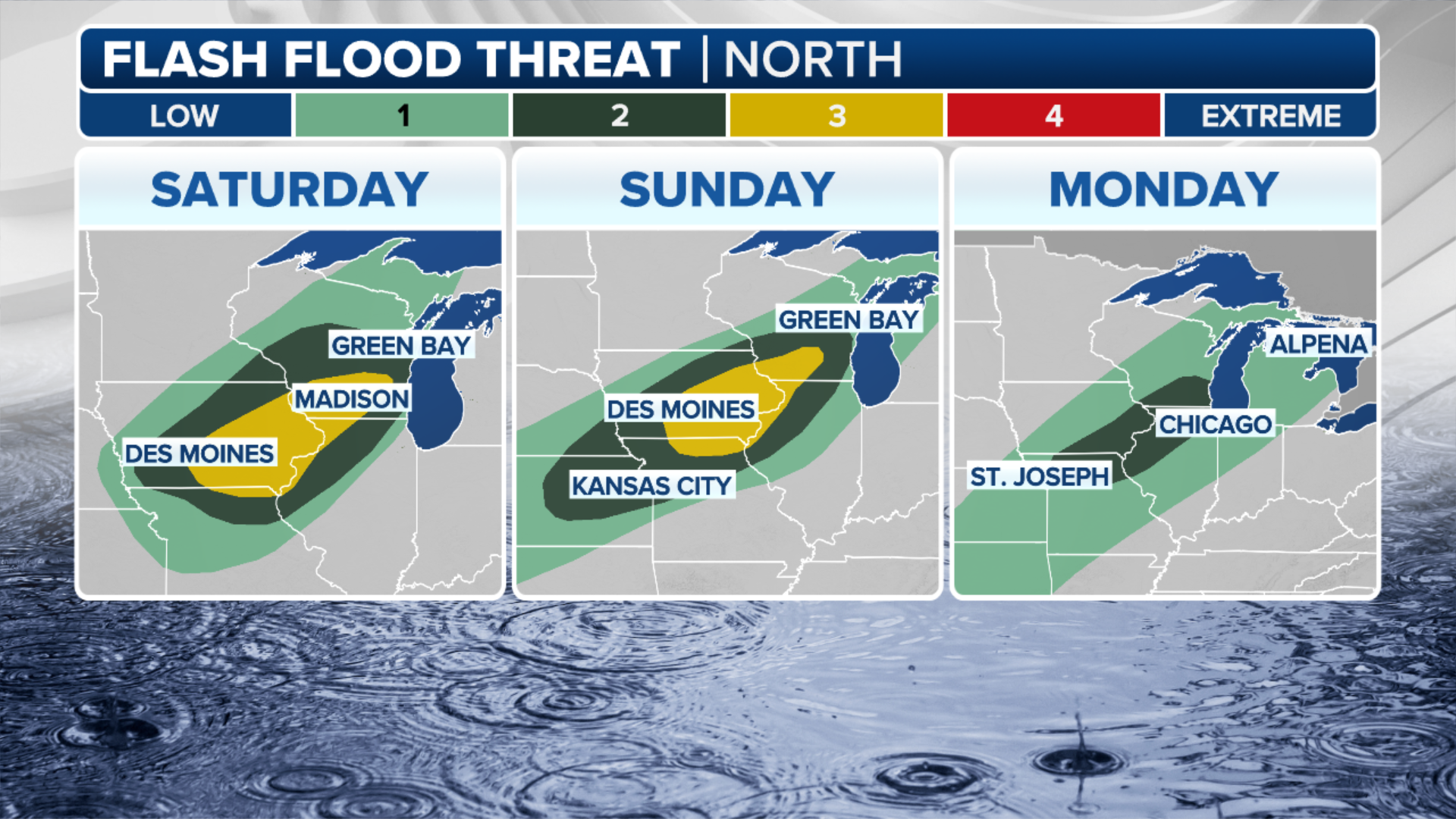
Significant flash flood threat continues in Midwest, Plains

Warning boxes are color coded as: Severe Thunderstorm Warnings in yellow, Tornado Warnings in red, Tornado Warnings with confirmed tornado in purple, Flash Flood Warnings in green, and Flash Flood Emergencies in pink.
(FOX Weather)
A slow-moving cold front will continue to bring torrential rain to portions of the Midwest and Plains with storms trailing over the same locations, creating a flood threat through Tuesday.
The FOX Forecast Center said the cold front is associated with a larger system in Canada that stalled out, stretching from Kansas to Wisconsin.
That stalled front is serving as the main trigger for the repeated rounds of heavy rain and extreme weather.
(FOX Weather)
Some storms are expected to produce extremely heavy rain, with rainfall rates between 2-3 inches an hour with multiday rainfall totals reaching 9 inches or more in some areas.
Because parts of the Midwest have already seen a surplus of rain in recent weeks, it hasn’t taken much for flooding to occur.
NOAA’s Weather Prediction Center (WPC) highlighted a Level 3 out of 4 flood threat in portions of Kansas and Missouri, and a Level 2 out of 4 threat from Colorado to Wisconsin.

(FOX Weather)
The flood threat will continue until at least the first part of the upcoming workweek.
Flood Watches have been issued in parts of six states – Kansas, Nebraska, Iowa, Missouri, Illinois and Wisconsin.