Snowflakes fly in Chicago after 'Manitoba Mauler' dumps snow on Minneapolis, heads for Great Lakes
The name may sound like the title of a horror movie, but a Manitoba Mauler is actually a clipper system that forms in Manitoba, Canada – similar to an Alberta Clipper but originates in a different Canadian province.
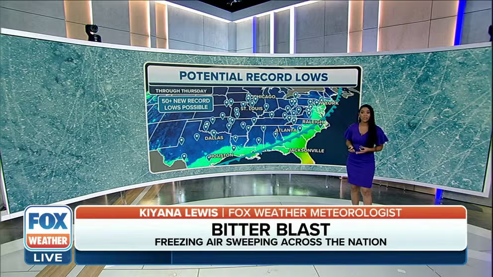
Freezing air sweeps across nation
A bitter blast of arctic air is bringing below-average temperatures for millions across the country.
CHICAGO – A fast-moving storm system known as a Manitoba Mauler moved through the northern Plains and Upper Midwest on Monday and Tuesday morning, bringing dangerous driving conditions to places like South Dakota and Minnesota due to accumulating snow and reduced visibility.
The first snowflakes of the season in Chicago started to fly Tuesday morning. As the system continues to sweep across the region, the Windy City and Milwaukee will see their first measurable snow of the season.
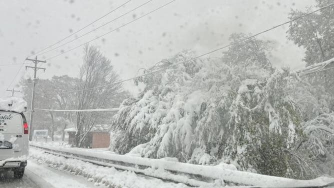
![Snowfall in Muskegon, MI. Oct. 31, 2023.]() Image 1 of 4
Image 1 of 4Snowfall in Muskegon, MI. Oct. 31, 2023. (@WMstormchaserDB / X)
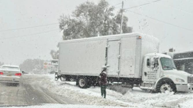
![Snowfall in Muskegon, MI. Oct. 31, 2023.]() Image 2 of 4
Image 2 of 4Snowfall in Muskegon, MI. Oct. 31, 2023. (@WMstormchaserDB / X)
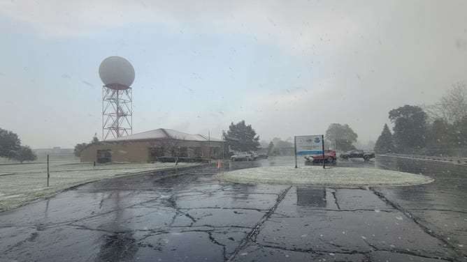
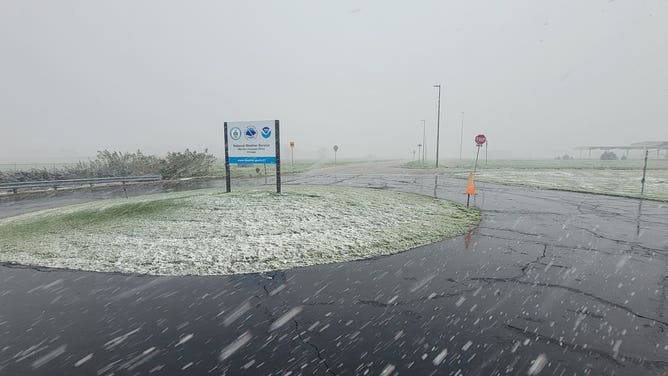
![Snowy conditions at the National Weather Service office in Chicago. Oct. 31, 2023.]() Image 3 of 4
Image 3 of 4Snowy conditions at the National Weather Service office in Chicago. Oct. 31, 2023. (@NWSChicago / X)
![Snowy conditions at the National Weather Service office in Chicago. Oct. 31, 2023.]() Image 4 of 4
Image 4 of 4Snowy conditions at the National Weather Service office in Chicago. Oct. 31, 2023. (@NWSChicago / X)
Minneapolis is already on the board, recording a few inches of snow overnight. On Tuesday morning, the National Weather Service said Minneapolis-St. Paul International Airport reported 2 inches of snow as of 7 a.m. CDT, tying the greatest daily snow depth the Twin Cities has ever had on Halloween. The other date was in 1905.

Snow falls in Chicago with more on the way Tuesday afternoon
FOX Weather correspondent Max Gorden is in Chicago where snow has already fallen thanks to a fast-moving winter storm system known as a Manitoba Mauler with more on the way later on Tuesday.
The name may sound like the title of a horror movie, but a Manitoba Mauler is actually a clipper system that forms in Manitoba, Canada – similar to an Alberta Clipper but originates in a different Canadian province. Clippers are named after fast-moving sailboats that raced between continents in the mid-1800s.
This type of fast-moving system is moisture-starved, so major accumulations that could significantly impact travel aren’t expected.
WHEN IS THE FIRST SNOW OF THE SEASON?
Snow to impact Halloween plans in the Midwest, Great Lakes
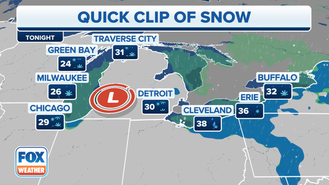
Forecast for Great Lakes area. Oct. 31, 2023.
(FOX Forecast Center / FOX Weather)
The storm system will continue to spin across parts of the Upper Midwest and into the Great Lakes region into the evening hours on Halloween. As it does, snow is expected to break out from west to east as temperatures will remain in the mid- to upper 30s in Chicago, Milwaukee and Wausau, Wisconsin.
By Halloween night, the storm system will be pushed farther to the east, bringing snow chances to cities such as Cleveland and Erie, Pennsylvania. Snow will also eventually begin to break out in the Buffalo and Watertown areas in New York.
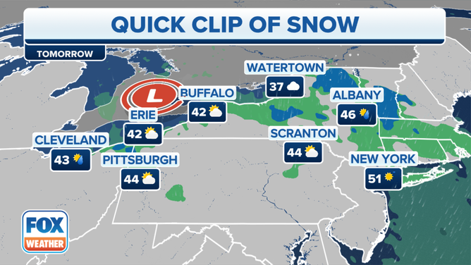
Forecast for Northeast. Nov. 1, 2023.
(FOX Forecast Center / FOX Weather)
The Manitoba Mauler will then push into the Northeast, and there’s a chance that higher elevations could see snow, including the Adirondack Mountains in New York state. Snow could also fall across central and southern Vermont and western Massachusetts.
How much snow will fall on Halloween?

(FOX Weather)
Several inches of snow have already fallen across portions of the northern Plains and Upper Midwest, but the FOX Forecast Center doesn't expect much more as the system continues its trek across the northern tier of the U.S.
Between 1 and 3 inches of snow is expected for most of Wisconsin, with locally higher amounts in northwestern portions of the state closer to Michigan's Upper Peninsula.
The same is true in Michigan, where most areas will only see a few inches of snow, with the highest amounts centered across the U.P.
How much snow fell in the Midwest?

While most areas impacted by the Manitoba Mauler only received a few inches of snow, there are locations that approached or went over a foot of snow.
Bergland in Michigan received 12.3 inches of snow so far, and Chassell wasn't far behind with 10 inches of snow. These higher totals were caused by lake enhancement from Lake Superior.

Watch: Snow squall drops visibility in South Dakota
Impressive video shows a snow squall dropping visibility in Waubay, South Dakota, when a storm system known as a Manitoba Mauler moved through the region on Monday, October 30, 2023.
Minnesota also picked up several inches of snow. Two Harbors has picked up more than 8 inches of snow, and Wales has picked up 6.5 inches.
Solon Springs in Wisconsin has so far received just under 7 inches of snow, with cities such as Washburn and Bayfield picking up 6 inches.