Blizzard warnings issued in West Virginia as parade of fast-moving clippers target Midwest, Northeast
A series of rapid-moving clippers across the Great Lakes through the Northeast will continue this month’s active pattern, as Winter Weather Alerts stretch for 1,200 miles, from North Dakota to New York.

Clipper intensifies as it makes its way to the upper Midwest, Winter Weather Alerts stretch for 1,200 miles
A fast-moving clipper is strengthening as it makes its way to the upper Midwest, triggering Winter Weather Alerts from North Dakota to New York and prompting wind gusts up to 65 mph across Nebraska, Wyoming and South Dakota. FOX Weather has the latest:
The month of December has been slammed with everything, from subzero temperatures to severe storm systems sweeping the nation and that’s just the beginning of it.
A series of rapid-moving clippers across the Great Lakes through the Northeast will continue this month’s active pattern, as Winter Weather Alerts stretch for 1,200 miles, from North Dakota to New York.

Winter Weather Alerts span through Thursday
(FOX Weather / FOX Weather)
The system started earlier this week and will track across the Midwest and Northern Tier through Saturday, piling regions with more snow, rain and high winds.

Future radar outlining weather conditions for upper Midwest and Northern Tier
Cities like Chicago have already seen up to 5 inches of snow from the first round, with more on the way.
![Snowy scenes throughout Chicago amid first round of clipper system]() Image 1 of 5
Image 1 of 5Snowy scenes throughout Chicago amid first round of clipper system (FOX Weather Correspondent Robert Ray)
![Snowy scenes throughout Chicago amid first round of clipper system]() Image 2 of 5
Image 2 of 5Snowy scenes throughout Chicago amid first round of clipper system (FOX Weather Correspondent Robert Ray)
![Snowy scenes throughout Chicago amid first round of clipper system]() Image 3 of 5
Image 3 of 5Snowy scenes throughout Chicago amid first round of clipper system (FOX Weather Correspondent Robert Ray)
![Snowy scenes throughout Chicago amid first round of clipper system]() Image 4 of 5
Image 4 of 5Snowy scenes throughout Chicago amid first round of clipper system (FOX Weather Correspondent Robert Ray)
![Snowy scenes throughout Chicago amid first round of clipper system]() Image 5 of 5
Image 5 of 5Snowy scenes throughout Chicago amid first round of clipper system (FOX Weather Correspondent Robert Ray)


FIRST ROUND OF FAST-MOVING CLIPPERS COULD BRING UP TO 6 INCHES OF SNOW TO CHICAGO
Accumulations will pile on top of the historic post-Thanksgiving storm that swept the country, prompting Chicago to have a nine-day snow total of 15 inches.
Areas across the Mid-Atlantic have already seen effects as well, as Monday brought half a foot of snow to the Virginia’s and Raleigh, North Carolina saw its snowiest December day since 2018.
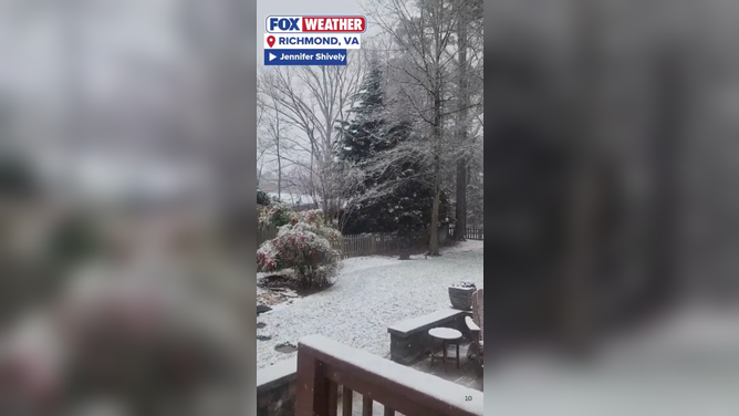
Snow in Richmond, Virginia Dec. 7.
(Jennifer Shively / FOX Weather)
MID-ATLANTIC SNOW CAUSING TRAVEL CONCERNS IN RICHMOND, VIRGINIA AMID OVERNIGHT FREEZE
Snow and wintry mixes continued to slam portions of these regions yesterday, prompting some fun snow days for kids, but posing dangerous situations for others, as travel became hazardous.
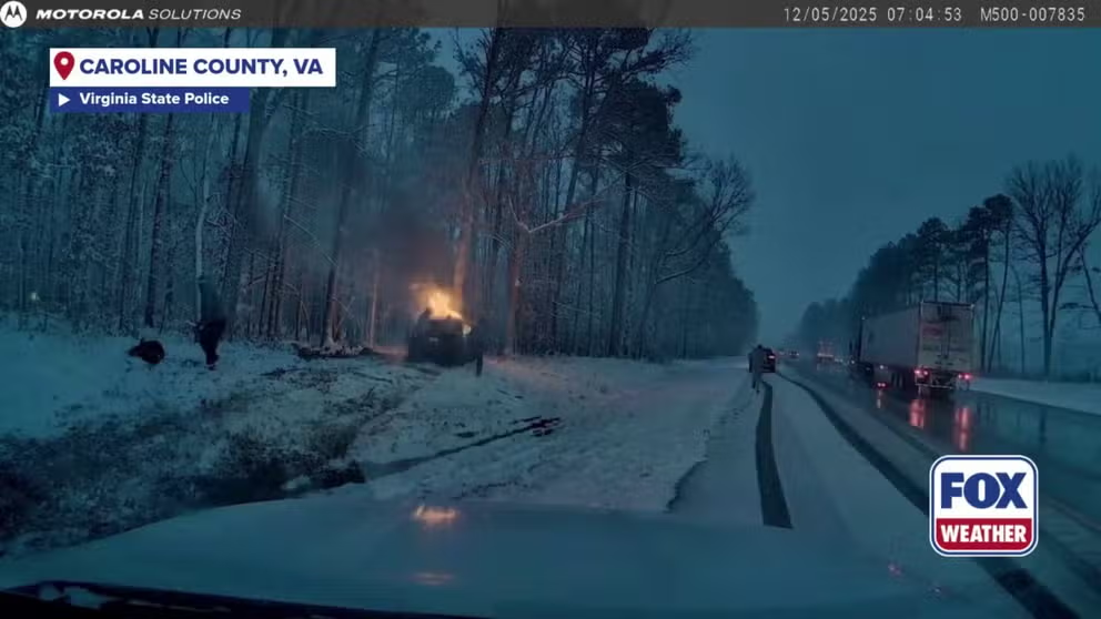
Virginia State Police trooper rescues driver from burning vehicle
HEROIC RESCUE: Virginia State trooper jumps into action to pull driver from burning vehicle in snowy conditions
While the first round was weaker, it sets the rest of the system up for strong impacts across the Great Lakes and Northern Tier through Saturday.
The core of today's storm will be positioned over Michigan and tracks to the Northeast.
It comes with strong winds that will cause blizzard conditions for the Midwest and Plains, with fresh snow mixing with gusts up to 65 mph, as Blizzard Warnings are already in effect for West Virginia.

Wind gust forecast for Midwest regions
(FOX Weather / FOX Weather)
Places like upstate New York and Pennsylvania are issued Winter Weather Advisories and Winter Storm Watches as snow moves through, with a widespread total of 3 to 5 inches across portions of the Northeast and Great Lakes.

Northern snow outlook through Sunday
(FOX Weather)
Higher totals are possible in Lakes Michigan and Ontario, where lake-effect snow can occur and the Tug Hill Plateau is likely to reach up to a foot of snow.
DANGEROUS LAKE-EFFECT SNOWSTORM BRINGS WINTER PREVIEW, WHITEOUT TRAVEL CONDITIONS ACROSS GREAT LAKES
By Thursday, the storm will move out of the Northern Tier and a second system will come into the Midwest and Ohio Valley, continuing to track across central Iowa by late night.
This will then bring snow to Northeastern portions of the state, stretching into northern Illinois and areas such as Chicago will again see more snow as the clipper pushes farther south and east into Friday.
WINTER HERE TO STAY FOR CHICAGO

Next clipper system tracking Thursday into Friday
(FOX Weather / FOX Weather)
By Friday, the snow pulls out of Illinois and moves into Indiana and portions of Ohio, where cities like Indianapolis, Chicago and Columbus could see up to 3 inches of snow, with localized amounts up to 5 inches.
Higher snow totals will be possible for West Virginia and Maryland and along Lake Eire and Ontario.
Stay tuned with FOX Weather as the system develops over the week.