Results are in: Last winter indeed resembled classic El Nino pattern
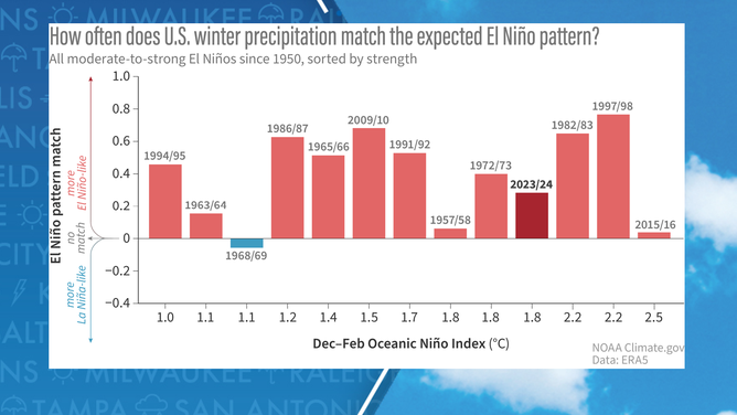
On a scale that runs from -1 to +1, with values around +1 indicating an exact match between the observed pattern and a typical El Niño and -1 being the complete opposite, NOAA estimated the previous winter season came in around a 0.3.
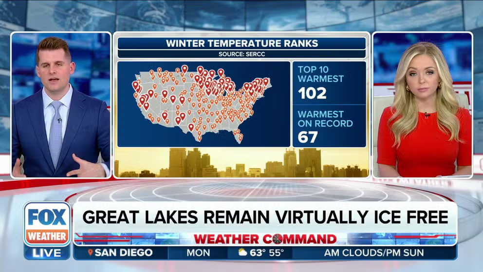
US had warmest winter on record
Winter 2023/2024 goes into U.S. history as the warmest in 130 years of recordkeeping. FOX Weather has details about how El Nino was responsible.
WASHINGTON – Scientists with NOAA say a reanalysis of winter 2023-24 shows the season matched remarkably to a classic El Niño pattern, but there were subtle differences when it came to precipitation patterns.
The strong El Niño started in June 2023 and strengthened throughout the winter, causing the U.S. to have a generally warmer and wetter season than is typical.
Notably, anomalies existed in the Pacific Northwest and Northeast, where more moisture was present than is typical during an El Niño pattern, and the South was a bit drier than is normal.
Typically, during a significant El Niño event, the southern tier of the country sees wetter conditions while more of the northern tier remains dry.
Due to the warmth experienced during the past winter, precipitation that usually falls in the form of snow, fell mostly in the liquid variety, helping cities stay out of drought conditions.
For example, the I-95 corridor largely remained free of significant snowstorms; however, the region stayed drought-free due to frequent rainfall events.
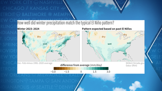
Winter 2023-24 weather precipitation pattern
(FOX Weather)
SITE: RARE ‘SUPER’ EL NINO ARRIVE BUT RAPID COLLAPSE BEGINNING AS LA NINA WATCH ISSUED
On a scale that runs from -1 to +1, with values around +1 indicating an exact match between the observed pattern and a typical El Niño and -1 being the complete opposite, NOAA estimated the previous winter season came in around a 0.3.
The result was similar to values experienced during El Niños in 1994-95, 1991-92 and 1972-73, but fell short of the classic patterns experienced in 1997-98 and 2009-10.
Out of all the El Niño winter seasons examined since the 1950s, only one event that was characterized as an official El Niño actually produced La Niña conditions.
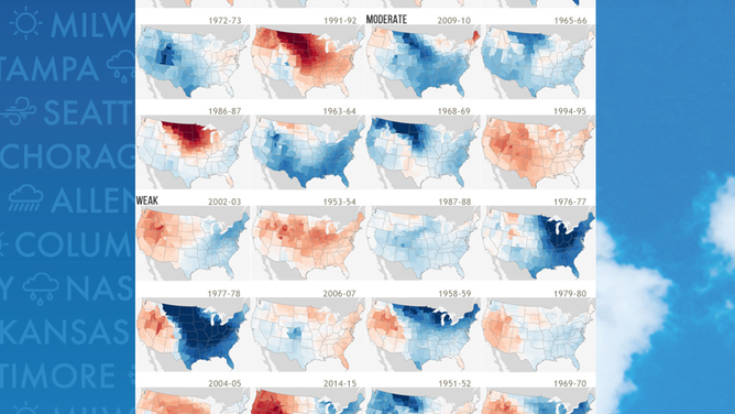
Overall correlation that shows how El Nino events compare to normal.
(NOAA)
"We can affirm a decent match with the expected El Niño influence," Nat Johnson, a NOAA meteorologist, stated in the latest winter summary update. "While El Niño provides a predictable signal, other factors, including internal variability and climate phenomena, can influence weather patterns."
Scientists admit that an agreement within the weather community between what is caused by climate change and what is solely the result of an El Niño has gotten murky over the last several years as weather extremes have increased.
LITTLE-KNOWN WEATHER PATTERN WHEN EL NIÑO AND LA NIÑA ARE NO LONGER IN CONTROL
Climate models show El Niño on last leg
Recent sea-surface temperature observations in sections of the central and eastern Pacific Ocean indicate water temperatures have dropped nearly a degree since their peak in February, and if the trend continues, the El Niño-Southern Oscillation, or what is commonly referred to as the ENSO, could drop into neutral status.
The neutral state of the ENSO occurs when water temperature anomalies in the eastern and central Pacific are between 0.5 °C and -0.5 °C.
Similarly to when El Niño and La Niña are in control, neutral conditions impact weather across the country and around the globe.
Typically, there are fewer kinks in the jet stream, meaning more regional patterns dominate local weather.
The recent NOAA analysis did not delve into temperatures experienced during the 2023-24 winter season, but much like the rainfall, there were minimal deviations from what previous strong El Niño events have produced.
The winter ranked warmest on record across the contiguous U.S., displacing the record set during the 2015-16 season.
U.S. winters during El Ninos
(FOX Weather)